
Gesamtpreis (1 Artikel Artikel):
Versandziel:

carta jerusalem (23 Ergebnisse)
Direkt zu den wichtigsten Suchergebnissen
Suchfilter
Produktart
- Alle Product Types
- Bücher (22)
- Magazine & Zeitschriften (Keine weiteren Ergebnisse entsprechen dieser Verfeinerung)
- Comics (Keine weiteren Ergebnisse entsprechen dieser Verfeinerung)
- Noten (Keine weiteren Ergebnisse entsprechen dieser Verfeinerung)
- Kunst, Grafik & Poster (Keine weiteren Ergebnisse entsprechen dieser Verfeinerung)
- Fotografien (Keine weiteren Ergebnisse entsprechen dieser Verfeinerung)
- Karten (1)
- Manuskripte & Papierantiquitäten (Keine weiteren Ergebnisse entsprechen dieser Verfeinerung)
Zustand Mehr dazu
- Neu (9)
- Wie Neu, Sehr Gut oder Gut Bis Sehr Gut (2)
- Gut oder Befriedigend (8)
- Ausreichend oder Schlecht (Keine weiteren Ergebnisse entsprechen dieser Verfeinerung)
- Wie beschrieben (4)
Einband
- alle Einbände
- Hardcover (Keine weiteren Ergebnisse entsprechen dieser Verfeinerung)
- Softcover (12)
Weitere Eigenschaften
- Erstausgabe (2)
- Signiert (Keine weiteren Ergebnisse entsprechen dieser Verfeinerung)
- Schutzumschlag (1)
- Angebotsfoto (8)
- Keine Print-on-Demand Angebote (23)
Sprache (2)
Gratisversand
Land des Verkäufers
Verkäuferbewertung
-

Carta's Compact Bible Atlas
Anbieter: ThriftBooks-Atlanta, AUSTELL, GA, USA
Verkäuferbewertung 5 von 5 Sternen

Paperback. Zustand: Good. No Jacket. Pages can have notes/highlighting. Spine may show signs of wear. ~ ThriftBooks: Read More, Spend Less.
-

Zustand: good. Befriedigend/Good: Durchschnittlich erhaltenes Buch bzw. Schutzumschlag mit Gebrauchsspuren, aber vollständigen Seiten. / Describes the average WORN book or dust jacket that has all the pages present.
-
paperback. Zustand: Good. Connecting readers with great books since 1972! Used textbooks may not include companion materials such as access codes, etc. May have some wear or writing/highlighting. We ship orders daily and Customer Service is our top priority!
-

Carta's Illustrated Calendar of Biblical Times
Sprache: Englisch
Verlag: Carta,The Israel Map & Publishing Company Ltd,Israel, 2014
ISBN 10: 9652205729 ISBN 13: 9789652205728
Anbieter: Grand Eagle Retail, Bensenville, IL, USA
Verkäuferbewertung 5 von 5 Sternen
Zustand: new. Compiled by eminent scholars of biblical history, Carta's Illustrated Calendar of Biblical Times provides a comparative view of parallel cultures during the time of the Bible. Enhanced by contemporary artifacts and images, the time line gives both a general overview (from c. 3000 B.C. to A.D. 200) of the major historical events in the Ancient Near East, Palestine, Egypt and the West, and a detailed section, beginning from c. 1650 B.C., that highlights the biblical period and its rulers, kings, and prophets. Carta's Illustrated Calendar of Biblical Times is perfect for Sunday School or homeschool classrooms. 3 BC AD 15. Compiled by eminent scholars of biblical history, this chart provides a comparative view of parallel cultures in the time of the Bible. Enhanced by contemporary artifacts and images, the time line gives both a general overview from c. 3000 B.C. to A.D. 200 of the major historical events in the Ancient Near East, Palestine, Egypt and the West, and a detailed section, beginning from c. 1650 B.C., that highlights the biblical period and its rulers, kings, and prophets. Shipping may be from multiple locations in the US or from the UK, depending on stock availability.
-

Atlas of the Bible: Index and Chronological Table
Anbieter: WeBuyBooks, Rossendale, LANCS, Vereinigtes Königreich
Verkäuferbewertung 5 von 5 Sternen
EUR 10,32
EUR 12,34 Versand
Versand von Vereinigtes Königreich nach USAAnzahl: 1 verfügbar
In den WarenkorbZustand: Good. Most items will be dispatched the same or the next working day. A copy that has been read but remains in clean condition. All of the pages are intact and the cover is intact and the spine may show signs of wear. The book may have minor markings which are not specifically mentioned.
-

Millennium Maps of the Holy Land (Folded)
Sprache: Englisch
Verlag: Carta, The Israel Map & Publishing Company, Jerusalem, 2015
ISBN 10: 9652206296 ISBN 13: 9789652206299
Anbieter: Grand Eagle Retail, Bensenville, IL, USA
Verkäuferbewertung 5 von 5 Sternen
Folded. Zustand: new. Folded. Carta's Millennium Maps of the Holy Land lays out four maps of the Holy Land from different eras side by side in one large wall poster for easy comparison. These maps, spanning from 1000 B.C. to A.D. 2000, give a snapshot of who had territorial control over the Holy Land at the turn of the first millennium B.C. (the time of David of Solomon), at the time of the birth of Jesus (the first millennium), the crusader kings (the second millennium), and Israel restored in our current third millennium. These Holy Land maps are eye-opening for those who want to see the changes in the region as they read along with the Bible. Straightforward and thorough, these four maps of the Holy Land are necessary additions to any Sunday School or homeschool classroom. Shipping may be from multiple locations in the US or from the UK, depending on stock availability.
-

Fronteras Seguras Y Reconocidas
Verlag: Carta, Jerusalem, 1974
Anbieter: Bookshop Baltimore, Baltimore, MD, USA
Verkäuferbewertung 5 von 5 Sternen
Softcover. Zustand: G. Spanish text only. Historia, El Factor Estrategico, Cambios Territoriales: el Ejemplo Europeo. Illustrated throughout with colored maps. El Derecho De Israel A Vivir En Paz Denrol De Fronteras Defensible 44 pages.
-

Russian Imperial Power in the Middle East
Erscheinungsdatum: 1972
Anbieter: 4 THE WORLD RESOURCE DISTRIBUTORS, Springfield, MO, USA
Verkäuferbewertung 5 von 5 Sternen
Pamphlet. Zustand: Good. 45 page pamphlet. ; 16mo 6" - 7" tall; 45 pages.
-
Secire Amd Recognized Boundaries -
Verlag: Carta Jerusalem Publishing -, 1971
Anbieter: "Pursuit of Happiness" Books, Oakland, CA, USA
Verkäuferbewertung 4 von 5 Sternen

Soft cover. Zustand: Good. PB/pub.1971/Fair condition/48 pages - This text discusses Israel's right to live in peace within defensible frontiers. [AT725655]. Book.
-
Russia Imperial Power in the Middle East
Verlag: Carta Jerusalem, 1972, 1972
Anbieter: "Pursuit of Happiness" Books, Oakland, CA, USA
Verkäuferbewertung 4 von 5 Sternen
Soft cover. Publisher: Carta Jerusalem, 1972, Good, Soft Cover, 45 pages. cover has crease. Book.
-
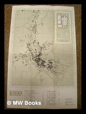
Map of Bethlehem / presented with the compliments of the Ministry of Tourism, Jerusalem
Verlag: Jerusalem : CARTA, 1967
Erstausgabe
First Edition. Near fine copy, with just some dulling around the edges. Remains particularly well-preserved overall. ; 8vo 8" - 9" tall; 1 pages; Fold-out tourist map of Bethlehem. Includes introductory text and photos. Folded: 10 x 24cm. Fold-out: 30 x 48cm. Subjects: Bethlehem -- Jerusalem -- Israel -- Holy Land -- Maps -- Tourist guides. 1 Kg.
-
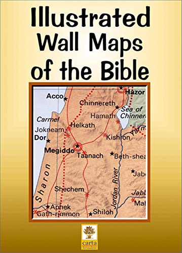
Iiustrated Wall Maps of the Bible (Folded)
Sprache: Englisch
Verlag: Carta,The Israel Map & Publishing Company Ltd,Israel, 2015
ISBN 10: 9652204935 ISBN 13: 9789652204936
Anbieter: Grand Eagle Retail, Bensenville, IL, USA
Verkäuferbewertung 5 von 5 Sternen
Folded. Zustand: new. Folded. From the ancient Near East to Palestine in the time of the New Testament, these visual resources will help deepen your understanding of Bible passages. Ideal for use in Sunday school, college, or seminary classrooms. This box sets includes 12 large color-coded maps (40" x 28" opened) and one copy of Atlas of the Bible -- a handy reference index and chronological table. Shipping may be from multiple locations in the US or from the UK, depending on stock availability.
-
Carta's Illustrated Calendar of Biblical Times
Sprache: Englisch
Verlag: Carta,The Israel Map & Publishing Company Ltd,Israel, 2014
ISBN 10: 9652205729 ISBN 13: 9789652205728
Anbieter: AussieBookSeller, Truganina, VIC, Australien
Verkäuferbewertung 5 von 5 Sternen
Zustand: new. Compiled by eminent scholars of biblical history, Carta's Illustrated Calendar of Biblical Times provides a comparative view of parallel cultures during the time of the Bible. Enhanced by contemporary artifacts and images, the time line gives both a general overview (from c. 3000 B.C. to A.D. 200) of the major historical events in the Ancient Near East, Palestine, Egypt and the West, and a detailed section, beginning from c. 1650 B.C., that highlights the biblical period and its rulers, kings, and prophets. Carta's Illustrated Calendar of Biblical Times is perfect for Sunday School or homeschool classrooms. 3 BC AD 15. Compiled by eminent scholars of biblical history, this chart provides a comparative view of parallel cultures in the time of the Bible. Enhanced by contemporary artifacts and images, the time line gives both a general overview from c. 3000 B.C. to A.D. 200 of the major historical events in the Ancient Near East, Palestine, Egypt and the West, and a detailed section, beginning from c. 1650 B.C., that highlights the biblical period and its rulers, kings, and prophets. Shipping may be from our Sydney, NSW warehouse or from our UK or US warehouse, depending on stock availability.
-

Map of Bethlehem / presented with the compliments of the Ministry of Tourism, Jerusalem
Verlag: Jerusalem : CARTA, 1967
Erstausgabe
First Edition. Near fine copy, with just some dulling around the edges. Remains particularly well-preserved overall. ; 8vo 8" - 9" tall; 1 pages; Fold-out tourist map of Bethlehem. Includes introductory text and photos. Folded: 10 x 24cm. Fold-out: 30 x 48cm. Subjects: Bethlehem -- Jerusalem -- Israel -- Holy Land -- Maps -- Tourist guides. 1 Kg. Item is Shipped from Ireland or US locations.
-

Illustrated Wall Maps of the Bible
Anbieter: GreatBookPrices, Columbia, MD, USA
Verkäuferbewertung 5 von 5 Sternen
Zustand: As New. Unread book in perfect condition.
-

Carta's Physical Map of Israel
Sprache: Englisch
Verlag: Carta,The Israel Map & Publishing Company Ltd,Israel, 2015
ISBN 10: 9652208183 ISBN 13: 9789652208187
Anbieter: Book Broker, Berlin, Deutschland
Verkäuferbewertung 5 von 5 Sternen
Zustand: Sehr gut. Fol Map. 2 S. Alle Bücher & Medienartikel von Book Broker sind stets in gutem & sehr gutem gebrauchsfähigen Zustand. Die Ausgabe des gelieferten Exemplars kann um bis zu 10 Jahre vom angegebenen Veröffentlichungsjahr abweichen und es kann sich um eine abweichende Auflage handeln. Unser Produktfoto entspricht dem hier angebotenen Artikel, dieser weist folgende Merkmale auf: Helle/saubere Seiten in fester Bindung. Sprache: Englisch Gewicht in Gramm: 45 map, Maße: 13.49 cm x 23.65 cm x 24.13 cm.
-
Millennium Maps of the Holy Land (Folded)
Sprache: Englisch
Verlag: Carta, The Israel Map & Publishing Company, Jerusalem, 2015
ISBN 10: 9652206296 ISBN 13: 9789652206299
Anbieter: AussieBookSeller, Truganina, VIC, Australien
Verkäuferbewertung 5 von 5 Sternen
Folded. Zustand: new. Folded. Carta's Millennium Maps of the Holy Land lays out four maps of the Holy Land from different eras side by side in one large wall poster for easy comparison. These maps, spanning from 1000 B.C. to A.D. 2000, give a snapshot of who had territorial control over the Holy Land at the turn of the first millennium B.C. (the time of David of Solomon), at the time of the birth of Jesus (the first millennium), the crusader kings (the second millennium), and Israel restored in our current third millennium. These Holy Land maps are eye-opening for those who want to see the changes in the region as they read along with the Bible. Straightforward and thorough, these four maps of the Holy Land are necessary additions to any Sunday School or homeschool classroom. Shipping may be from our Sydney, NSW warehouse or from our UK or US warehouse, depending on stock availability.
-
Illustrated Wall Maps of the Bible
Anbieter: Kennys Bookshop and Art Galleries Ltd., Galway, GY, Irland
Verkäuferbewertung 5 von 5 Sternen
Zustand: New. Num Pages: 22 pages, 22 sheet maps. BIC Classification: 1FBH; HBTP1. Category: (G) General (US: Trade). Dimension: 363 x 261 x 25. Weight in Grams: 1252. . 1998. Fol Pstr. Map. . . . .
-

Illustrated Wall Maps of the Bible
Anbieter: GreatBookPrices, Columbia, MD, USA
Verkäuferbewertung 5 von 5 Sternen
Zustand: New.
-
Illustrated Wall Maps of the Bible
Anbieter: Kennys Bookstore, Olney, MD, USA
Verkäuferbewertung 4 von 5 Sternen
Zustand: New. Num Pages: 22 pages, 22 sheet maps. BIC Classification: 1FBH; HBTP1. Category: (G) General (US: Trade). Dimension: 363 x 261 x 25. Weight in Grams: 1252. . 1998. Fol Pstr. Map. . . . . Books ship from the US and Ireland.
-
Secure and Recognized Boundaries Israel's Right to live in Peace within Defensible Frontiers
Verlag: Carta Jerusalem, Israel, 1971
Anbieter: Edmonton Book Store, Edmonton, AB, Kanada
Verkäuferbewertung 4 von 5 Sternen
Zustand: very good. Zustand des Schutzumschlags: no dustjacket. 8vo pp.48. book.
-
Iiustrated Wall Maps of the Bible (Folded)
Sprache: Englisch
Verlag: Carta,The Israel Map & Publishing Company Ltd,Israel, 2015
ISBN 10: 9652204935 ISBN 13: 9789652204936
Anbieter: AussieBookSeller, Truganina, VIC, Australien
Verkäuferbewertung 5 von 5 Sternen
Folded. Zustand: new. Folded. From the ancient Near East to Palestine in the time of the New Testament, these visual resources will help deepen your understanding of Bible passages. Ideal for use in Sunday school, college, or seminary classrooms. This box sets includes 12 large color-coded maps (40" x 28" opened) and one copy of Atlas of the Bible -- a handy reference index and chronological table. Shipping may be from our Sydney, NSW warehouse or from our UK or US warehouse, depending on stock availability.
-
Map of Bethlehem.
Erscheinungsdatum: 1970
Anbieter: Geographicus Rare Antique Maps, Brooklyn, NY, USA
Verbandsmitglied: ABAA ESA ILAB
Verkäuferbewertung 5 von 5 Sternen
Karte
Very good. Light wear along original fold lines. Size 18 x 11.5 Inches. This is a 1970 Carta Jerusalem pictorial tourist map of Bethlehem, West Bank, Israel. Profile illustrations depict sites across the city, including the Basilica of the Nativity, the Chapel of the Milk Grotto, King David's Well, the Omar Mosque, and Rachel's Tomb. Several churches and convents are also illustrated in profile, along with schools, cinemas, and hotels. Important parts of modern society, including a taxi station, gas (petrol) stations, and the Health Department are identified as well. Verso Content A map of the environs of Bethlehem occupies part of the verso and marks historic sites alongside picnic locations and smaller villages outside of town. Short descriptions of some of the sites appear on the verso as well, along with a short history of Bethlehem. Two photographs, one of Bethlehem and one of the Latin Convent, also are included. Publication History and Census This map was created and copyrighted by Carta Jerusalem and published by the Ministry of Tourism in 1970. We note one example cataloged in OCLC, at Brigham Young University. References: OCLC 890201591.

