
Gesamtpreis (1 Artikel Artikel):
Versandziel:

chapman john andré peter (28 Ergebnisse)
Direkt zu den wichtigsten Suchergebnissen
Suchfilter
Produktart
- Alle Product Types
- Bücher (7)
- Magazine & Zeitschriften (Keine weiteren Ergebnisse entsprechen dieser Verfeinerung)
- Comics (Keine weiteren Ergebnisse entsprechen dieser Verfeinerung)
- Noten (Keine weiteren Ergebnisse entsprechen dieser Verfeinerung)
- Kunst, Grafik & Poster (Keine weiteren Ergebnisse entsprechen dieser Verfeinerung)
- Fotografien (Keine weiteren Ergebnisse entsprechen dieser Verfeinerung)
- Karten (21)
- Manuskripte & Papierantiquitäten (Keine weiteren Ergebnisse entsprechen dieser Verfeinerung)
Zustand Mehr dazu
- Neu (Keine weiteren Ergebnisse entsprechen dieser Verfeinerung)
- Wie Neu, Sehr Gut oder Gut Bis Sehr Gut (Keine weiteren Ergebnisse entsprechen dieser Verfeinerung)
- Gut oder Befriedigend (22)
- Ausreichend oder Schlecht (Keine weiteren Ergebnisse entsprechen dieser Verfeinerung)
- Wie beschrieben (6)
Einband
Weitere Eigenschaften
- Erstausgabe (1)
- Signiert (Keine weiteren Ergebnisse entsprechen dieser Verfeinerung)
- Schutzumschlag (2)
- Angebotsfoto (24)
- Keine Print-on-Demand Angebote (28)
Sprache (1)
Preis
- Beliebiger Preis
- Weniger als EUR 20 (Keine weiteren Ergebnisse entsprechen dieser Verfeinerung)
- EUR 20 bis EUR 45
- Mehr als EUR 45
Gratisversand
Land des Verkäufers
Verkäuferbewertung
-
A Reproduction of their Map of the County of Essex 1777.
Verlag: Essex County Council Chelmsford, 1950
Anbieter: Bristow & Garland, Shaftesbury, Vereinigtes Königreich
Verkäuferbewertung 4 von 5 Sternen

EUR 41,27
Währung umrechnenEUR 16,03 für den Versand von Vereinigtes Königreich nach USAAnzahl: 1 verfügbar
In den WarenkorbFrontispiece and 24-plates. Oblong folio (12 3/4 x 10 inches), original wrappers stitched as issued. Wrapprs dusty and spotted, internally very good.
-

A Reproduction of a Map of the County of Essex 1777.
Verlag: J. H. Clarke & Co., 1950
Anbieter: Allsop Antiquarian Booksellers PBFA, Warwick, Vereinigtes Königreich
Verbandsmitglied: PBFA
Verkäuferbewertung 3 von 5 Sternen

EUR 41,27
Währung umrechnenEUR 32,06 für den Versand von Vereinigtes Königreich nach USAAnzahl: 1 verfügbar
In den WarenkorbHardcover. Zustand: Very Good. Zustand des Schutzumschlags: Good. Illus. with b.w. maps. 4to. orig. cl. Some dicolouration to title page, and final page, else generally v.g. in chipped and slightly torn d/w.
-

A Reproduction of a Map of the County of Essex 1777
Verlag: The Essex County Council, Chelmsford, Essex, 1950
Anbieter: C P Books Limited, Oxted, Vereinigtes Königreich
Verkäuferbewertung 3 von 5 Sternen
EUR 141,51
Währung umrechnenEUR 24,25 für den Versand von Vereinigtes Königreich nach USAAnzahl: 1 verfügbar
In den WarenkorbHardcover. Zustand: Very Good-. Zustand des Schutzumschlags: Fair. Facsimile. Spine & corners bumped, creasing on cover, browning on front ep, and last map page. Wear, nicks and creasing on DJ, Browning on inside of DJ. ; Sheet of Notes concerning this publication loosely inserted. ; Essex Record Office Publications; Vol. 5; B&W Maps; 10.5 x 13.1 x 0.15"; non paginated pages.
-
A Reproduction of A Map of the County of Essex 1777
Anbieter: Oast Park Books, Southend -on- Sea, ESSEX, Vereinigtes Königreich
Verkäuferbewertung 5 von 5 Sternen

EUR 35,38
Währung umrechnenEUR 22,90 für den Versand von Vereinigtes Königreich nach USAAnzahl: 1 verfügbar
In den Warenkorb1960. Essex Records Office Publications. Soft covers. Book - Good. (2 Copies).
-
![Bild des Verkäufers für A.W.C. : Open Hearing / An Open Public Hearing on the Subject : What Should be the Program of the Art Workers Regarding Museum Reform and to Establish the Program of an Open Art Workers Coalition [AWC] zum Verkauf von Specific Object / David Platzker](https://pictures.abebooks.com/inventory/md/md30287676764.jpg)
A.W.C. : Open Hearing / An Open Public Hearing on the Subject : What Should be the Program of the Art Workers Regarding Museum Reform and to Establish the Program of an Open Art Workers Coalition [AWC]
Verlag: Art Workers Coalition New York, NY, 1969
Anbieter: Specific Object / David Platzker, New York, NY, USA
Verkäuferbewertung 5 von 5 Sternen
Erstausgabe
EUR 310,11
Währung umrechnenEUR 7,31 für den Versand innerhalb von/der USAAnzahl: 3 verfügbar
In den Warenkorb142 pp.; 28 x 20.5 cm.; staple bound; black-and-white; edition size unknown; unsigned and unnumbered; offset-printed The report from the Art Workers Coalition hearing on April 10, 1969, printed in order to bring each artist's opinion on museum reform to the attention of all art workers and all art institutions in New York City and elsewhere. Includes contributions in the form of statements by Carl Andre, Architects Resistance, Robert Barry, Gregory Battcock, Jon Bauch, Ernst Benkert, Don Bernshouse, Gloria Greenberg Bressler, Selma Brody, Bruce Brown, Bob Carter, Fredrick Castle, Rosemarie Castoro, Michael Chapman, Iris Crump, John Denmark, Joseph Di Donato, Mark Di Suvero, George Dworzan, Farman, Hollis Frampton, Dan Graham, Chuck Ginnever, Bill Gordy, Alex Gross, Hans Haacke, Clarence Hagin, Harvey, Gerry Herman, Frank Hewitt, D. Holmes, Robert Huot, Ken Jacobs, Joseph Kosuth, David Lee, Naomi Levine, Sol LeWitt, Lucy Lippard, Tom Lloyd, Lee Lozano, Len Lye, James McDonald, Edwin Mieczkowski, Vernita Nemec, Barnett Newman, John Perreault, Stephen Phillips, Lil Picard, Peter Pinchbeck, Joanna Pousette-Dart, Barbara Reise, Faith Ringold, Steve Rosenthal, Theresa Schwarz, Seth Siegelaub, Gary Smith, Michael Snow, Anita Steckel, Carl Strueckland, Gene Swenson, Julius Tobias, Jean Toche, Ruth Vollimer, Iain Whitecross, Jay Wholly, Ann Wilson, and Wilbur Woods. Reference : "Materializing Six Years : Lucy R. Lippard and the Emergence of Conceptual Art" by Catherine Morris, Vincent Bonin, Julia Bryan-Wilson. Brooklyn / Cambridge, NY / MA : Brooklyn Museum / MIT Press, 2012, pp. 72. Fine. First printing, clean and unmarked as issued.
-
A Map of the County of Essex from an Actual Survey taken in MDCCLXXII, :LXXIII and MDCCLXXIV
Verlag: Colchester: W. Keymer, June 1785., 1785
Anbieter: Arader Galleries - AraderNYC, New York, NY, USA
Verkäuferbewertung 5 von 5 Sternen
EUR 3.366,87
Währung umrechnenKostenlos für den Versand innerhalb von/der USAAnzahl: 1 verfügbar
In den Warenkorb26 engraved sheets (at the time of publication joined and laid down on canvas to make a continuous roll with wooden rollers, repaired in the 20th-century when paper dividers with type-written explanatory text were added between five runs of the complete width of the finished map, each ca 18 6/8 x 115 inches), a magnificent map of Essex, complete with a key map after that of Thomas Sparrow of 1767, insets of Colchester and Harwich Harbour, and a list of Subscribers; one whole sheet decorated with and devoted to a superb large historiated title cartouche showing a fulling mill with fullers at work beating woolen cloth in the water, all with original hand-colour in full (rollers absent, some browning, spotting, and one or two short tears). Provenance: with two red arrows affixed in the 20th-century to the sheet containing Bridge House near Leaden Roding and another to Millers Green near Willingale Doe. Second edition, first published in October of 1777 and sold in 1778 for 2 pounds 12 shillings and 6 pence for uncoloured copies, 4 pounds 4 shillings for the map half bound and fully coloured, and on canvas and rollers fully coloured for 5 pounds and 5 shillings (as here). In 1762 the Society of Arts offered a prize to anyone "who shall make an accurate survey of any county upon the scale of one inch to a mile". Naturally local landowners were very willing to finance these maps by subscription, which was probably about half the price of the published map. Chapman and Andre's map epic map was not the first of these, but is one of the very best. Chapman and Andre's survey of Essex completed over the course of two years, was the most exhaustive since that of the Domesday survey completed in 1086, and resulted in this magnificent and decorative large-scale map (2" = 1 mile). Rich in detail, and extremely accurate, with each hundred outlined; every estate, country manor, house, farm, cottage and landowner named; ancient roadways and minor tracks delineated; milestones and turnpikes recorded; and the Essex coastline, so vital to the county's economy, is shown in the same exacting detail. In addition to the whole sheet devoted to the title cartouche, one sheet provides the Key Map showing how the individual sheets join to make one large and extremely impressive wall map; another contains a map of Harwich Harbour, and another a plan of Colchester; a fourth lists 216 subscribers for 240 copies of the map, including most of the major land owners of Essex; Lord Petre and Richard Rigby ordered four copies each. Other notable subscribers include the topographer Richard Gough, the landscape gardener Richard Woods, and most impressively the founder of the Ordnance Survey Colonel Roy. Chapman died suddenly in 1778 before all the subscribed copies were even printed, let alone delivered. Randall the bookseller at the Royal Academy where Chapman had his London offices distributed some maps to original subscribers in 1779; but it wasn't until this edition, published by Keymer in 1785, after purchasing the original copper-plates at a Christie's auction in 1784, that all subscribers still interested were satisfied. Chapman is known to have been a land surveyor in Dalham, Suffolk before embarking on this map of Essex, his most heroic venture. He is recorded as joint publisher of Andrew Armstrong's map of the County of Durham in 1768, and provided 21 fine illustrations of Essex for a "History of Essex" 'by a gentleman' (ie Peter Muilman) published in parts between 1769 and 1771, as well as one or two estate maps for Essex landowners. Shortly thereafter, probably at the suggestion of Mary-Ann Rocque (surveyor, engraver, mapmaker, map-seller and publisher John Rocque's widow), Chapman, with the help of one of Rocque's protégés Peter Andre, began this survey of Essex. Once completed Chapman surveyed (1774) and published (1776) a map of Nottinghamshire, and engraved the plates for a large scale map of Staffordshire (1775). Adair Stuart Mason, "Esse.
-
A MAP OF THE COUNTY OF ESSEX from an Actual Survey.
Verlag: Published as the Act directs Oct. 1st Chapman John and Andre Peter, 1777
Anbieter: AMBRA BOOKS (Aitchison & Cornish), Bristol, Vereinigtes Königreich
Verkäuferbewertung 3 von 5 Sternen
EUR 235,85
Währung umrechnenEUR 21,75 für den Versand von Vereinigtes Königreich nach USAAnzahl: 1 verfügbar
In den WarenkorbThis is the key map to their large scale survey. Engraved, dissected and mounted on linen, size 18" x 23", plus margins, with a compass rose, a vignette cartouche and inset plans of Harwich and Colchester. Folding into a small 8vo marbled slipcase, with the original label titled:- 'Essex. Sold by Wm Faden Geographer to the King, Charing Cross.' Slipcase slightly rubbed, light browning and small stain to linen, but map clean. --- Please e-mail for one of my FREE CATALOGUES which include ESSEX [ Manuscripts, Maps, Ephemera, Views, etc., etc. ] ---.
-
A Map of the County of Essex From an Actual Survey made in MDCCLXXII, MDCCLXXIII and MDCCLXXIV by John Chapman and Peter Andre.
Verlag: Chalk Meggy and Chalk, [1831]., London,, 1831
Anbieter: Daniel Crouch Rare Books Ltd, London, Vereinigtes Königreich
Verbandsmitglied: ABA ILAB PBFA
Verkäuferbewertung 4 von 5 Sternen
Karte
EUR 5.306,67
Währung umrechnenEUR 22,90 für den Versand von Vereinigtes Königreich nach USAAnzahl: 1 verfügbar
In den WarenkorbEssex - The finest large-scale map of Essex Folio (440 by 390 mm), index map, and 25 double-page engraved map sheets, all with fine original hand-colour, some minor offsetting, modern half calf over marbled paper boards. Chapman and André's survey of Essex was one of the most celebrated of the nineteenth century large-scale maps with a wealth of detail matched by extraordinary accuracy, even when checked against large-scale contemporary estate maps. Minor roads were depicted on a map of the county for the first time with bridges, milestones and turnpike gates, whilst on the long coastline every creek, wharf, quay, ferry, duck decoy and cliff is shown. The countryside is extensively delineated with hills, woods, parks and heaths clearly depicted and often named. Except in the towns and villages, nearly every house and cottage is marked, whilst the principal seats and their owners, and most of the manor houses, and farm houses are named. There are complete sheets devoted to the vignette title (an Essex fulling mill with two cloth beaters and Harwich and Dovercourt churches in the background), and a list of 240 subscribers. Further sheets include a general map of the county to serve as a key map, an outline of Harwich Harbour and a plan of Colchester on a scale of 168 yards to the inch including information about the town such as fairs and market days. It is unlikely that more than 300 copies of this edition were sold, though there was a second smaller edition issued in 1785. The twenty-one sheets covering the survey of the county, together with the rest of the atlas, are all fully coloured by a contemporary hand to make it one of the most competent and attractive of the large-scale surveys.
-

List of Subscribers
Erscheinungsdatum: 1777
Anbieter: Antiqua Print Gallery, London, Vereinigtes Königreich
Verkäuferbewertung 3 von 5 Sternen
Karte
EUR 88,44
Währung umrechnenEUR 11,45 für den Versand von Vereinigtes Königreich nach USAAnzahl: 1 verfügbar
In den WarenkorbZustand: Good. List of Subscribers to A Map of the County of Essex by Chapman & André 1777. Antique folio copperplate map with original full wash colour; John Chapman & Peter André (1777). 53.0 x 70.0cm, 20.75 x 27.5 inches; this is a folding map. Condition: Good. There is nothing printed on the reverse side, which is plain.
-
![Bild des Verkäufers für A map of the county of Essex from an actual survey taken in MDCCLXXII : LXXIII (1772-3) & MDCCLXXIV (1774) by John Chapman & Peter André, published as the Act directs Oct. 1st 1777 by John Chapman, No. 25, Chancery Lane, & Peter André, No. 1, Noel Street, Berwick Street, London. [Title page] zum Verkauf von Antiqua Print Gallery](https://pictures.abebooks.com/inventory/md/md32050480417.jpg)
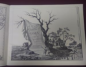
A map of the county of Essex from an actual survey taken in MDCCLXXII : LXXIII (1772-3) & MDCCLXXIV (1774) by John Chapman & Peter André, published as the Act directs Oct. 1st 1777 by John Chapman, No. 25, Chancery Lane, & Peter André, No. 1, Noel Street, Berwick Street, London. [Title page]
Erscheinungsdatum: 1777
Anbieter: Antiqua Print Gallery, London, Vereinigtes Königreich
Verkäuferbewertung 3 von 5 Sternen
Karte
EUR 153,30
Währung umrechnenEUR 11,45 für den Versand von Vereinigtes Königreich nach USAAnzahl: 1 verfügbar
In den WarenkorbZustand: Good. Title Page to A Map of the County of Essex by John Chapman & Peter André 1777. Antique folio copperplate map with original full wash colour; John Chapman & Peter André (1777). 53.0 x 70.0cm, 20.75 x 27.5 inches; this is a folding map. Condition: Good. There is nothing printed on the reverse side, which is plain.
-
![Bild des Verkäufers für Plate VI [Quendon, Clavering, Berden, Manuden, Farnham, Rickling, Birchanger, Hockerill, Great Hallingbury] zum Verkauf von Antiqua Print Gallery](https://pictures.abebooks.com/inventory/md/md32050481527.jpg)
Plate VI [Quendon, Clavering, Berden, Manuden, Farnham, Rickling, Birchanger, Hockerill, Great Hallingbury]
Erscheinungsdatum: 1777
Anbieter: Antiqua Print Gallery, London, Vereinigtes Königreich
Verkäuferbewertung 3 von 5 Sternen
Karte
EUR 235,85
Währung umrechnenEUR 11,45 für den Versand von Vereinigtes Königreich nach USAAnzahl: 1 verfügbar
In den WarenkorbZustand: Good. Essex NW #6 Uttlesford Clavering Manuden Birchanger. Chapman/André 1777 map. Antique folio copperplate map with original full wash colour; John Chapman & Peter André (1777). 53.0 x 70.0cm, 20.75 x 27.5 inches; this is a folding map. Condition: Good. Please contact us if you would like to arrange to view this map. There is nothing printed on the reverse side, which is plain. Large folio Plate VI from John Chapman & Peter André's 'Map of the County of Essex' (1777), covering part of northwest Essex including Quendon, Clavering, Berden, Manuden, Farnham, Rickling, Birchanger, Hockerill, Great Hallingbury.
-
![Bild des Verkäufers für Harwich Harbour' - Plate V [Ipswich, Harwich, River Orwell, Shotley, Woolverstone, Levington, Holbrook, Chelmondiston] zum Verkauf von Antiqua Print Gallery](https://pictures.abebooks.com/inventory/md/md32050472578.jpg)
Harwich Harbour' - Plate V [Ipswich, Harwich, River Orwell, Shotley, Woolverstone, Levington, Holbrook, Chelmondiston]
Erscheinungsdatum: 1777
Anbieter: Antiqua Print Gallery, London, Vereinigtes Königreich
Verkäuferbewertung 3 von 5 Sternen
Karte
EUR 271,23
Währung umrechnenEUR 11,45 für den Versand von Vereinigtes Königreich nach USAAnzahl: 1 verfügbar
In den WarenkorbZustand: Good. Harwich Harbour by Chapman/André. Essex/Suffolk #5 Ipswich River Orwell 1777 map. Antique folio copperplate map with original full wash colour; John Chapman & Peter André (1777). 53.0 x 70.0cm, 20.75 x 27.5 inches; this is a folding map. Condition: Good. Please contact us if you would like to arrange to view this map. There is nothing printed on the reverse side, which is plain. Large folio Plate V from John Chapman & Peter André's 'Map of the County of Essex' (1777), being an inset map of Harwich Harbour, and the River Orwell with adjacent towns and villages including Ipswich, Shotley, Woolverstone, Levington, Holbrook, Chelmondiston.
-
![Bild des Verkäufers für Plate XXIV [Great Wakering, Little Wakering, Barling, North Shoebury, South Shoebury] zum Verkauf von Antiqua Print Gallery](https://pictures.abebooks.com/inventory/md/md32050477620.jpg)
Plate XXIV [Great Wakering, Little Wakering, Barling, North Shoebury, South Shoebury]
Erscheinungsdatum: 1777
Anbieter: Antiqua Print Gallery, London, Vereinigtes Königreich
Verkäuferbewertung 3 von 5 Sternen
Karte
EUR 271,23
Währung umrechnenEUR 11,45 für den Versand von Vereinigtes Königreich nach USAAnzahl: 1 verfügbar
In den WarenkorbZustand: Good. Essex SE #24 Great Wakering Shoeburyness Southend-on-Sea. Chapman/André 1777 map. Antique folio copperplate map with original full wash colour; John Chapman & Peter André (1777). 53.0 x 70.0cm, 20.75 x 27.5 inches; this is a folding map. Condition: Good. Please contact us if you would like to arrange to view this map. There is nothing printed on the reverse side, which is plain. Large folio Plate XXIV from John Chapman & Peter André's 'Map of the County of Essex' (1777), covering part of southeast Essex including Great Wakering, Little Wakering, Barling, North Shoebury, South Shoebury.
-
![Bild des Verkäufers für Plate XIX [Mayland, Steeple, Southminster, Althorne, Creeksea, Asheldham, Dengey, Tilingham, St. Laurence, Burnham-on-Crouch, Paglesham] zum Verkauf von Antiqua Print Gallery](https://pictures.abebooks.com/inventory/md/md32050479452.jpg)
Plate XIX [Mayland, Steeple, Southminster, Althorne, Creeksea, Asheldham, Dengey, Tilingham, St. Laurence, Burnham-on-Crouch, Paglesham]
Erscheinungsdatum: 1777
Anbieter: Antiqua Print Gallery, London, Vereinigtes Königreich
Verkäuferbewertung 3 von 5 Sternen
Karte
EUR 306,61
Währung umrechnenEUR 11,45 für den Versand von Vereinigtes Königreich nach USAAnzahl: 1 verfügbar
In den WarenkorbZustand: Good. Essex SE #19 Maldon Burnham/Crouch Southminster Mayland. Chapman/André 1777 map. Antique folio copperplate map with original full wash colour; John Chapman & Peter André (1777). 53.0 x 70.0cm, 20.75 x 27.5 inches; this is a folding map. Condition: Good. Please contact us if you would like to arrange to view this map. There is nothing printed on the reverse side, which is plain. Large folio Plate XIX from John Chapman & Peter André's 'Map of the County of Essex' (1777), covering part of southeast Essex including Mayland, Steeple, Southminster, Althorne, Creeksea, Asheldham, Dengey, Tilingham, St. Laurence, Burnham-on-Crouch, Paglesham.
-
![Bild des Verkäufers für Plate XIV [Tolleshunt D'Arcy, Tolleshunt Major, Goldhanger, Salcott-cum-Virley, Mersea Island, West Mersea, Tollesbury, Layer Marney, Great Wigborough, Bradwell-on-Sea, Tolleshunt Knights, Great Wigborough, Layer Breton, Peldon, Langenhoe, Messing, Brightlingsea] zum Verkauf von Antiqua Print Gallery](https://pictures.abebooks.com/inventory/md/md32050475851.jpg)
Plate XIV [Tolleshunt D'Arcy, Tolleshunt Major, Goldhanger, Salcott-cum-Virley, Mersea Island, West Mersea, Tollesbury, Layer Marney, Great Wigborough, Bradwell-on-Sea, Tolleshunt Knights, Great Wigborough, Layer Breton, Peldon, Langenhoe, Messing, Brightlingsea]
Erscheinungsdatum: 1777
Anbieter: Antiqua Print Gallery, London, Vereinigtes Königreich
Verkäuferbewertung 3 von 5 Sternen
Karte
EUR 306,61
Währung umrechnenEUR 11,45 für den Versand von Vereinigtes Königreich nach USAAnzahl: 1 verfügbar
In den WarenkorbZustand: Good. Essex E #14 Maldon West Mersea Brightlingsea Tollesbury. Chapman/André 1777 map. Antique folio copperplate map with original full wash colour; John Chapman & Peter André (1777). 53.0 x 70.0cm, 20.75 x 27.5 inches; this is a folding map. Condition: Good. Please contact us if you would like to arrange to view this map. There is nothing printed on the reverse side, which is plain. Large folio Plate XIV from John Chapman & Peter André's 'Map of the County of Essex' (1777), covering part of east Essex including Tolleshunt D'Arcy, Tolleshunt Major, Goldhanger, Salcott-cum-Virley, Mersea Island, West Mersea, Tollesbury, Layer Marney, Great Wigborough, Bradwell-on-Sea, Tolleshunt Knights, Great Wigborough, Layer Breton, Peldon, Langenhoe, Messing, Brightlingsea.
-
![Bild des Verkäufers für Plate XV [Clacton-on-Sea, Great Holland, Little Holland, Frinton-on-Sea, Thorington, St. Osyth, Jaywick] zum Verkauf von Antiqua Print Gallery](https://pictures.abebooks.com/inventory/md/md32050471679.jpg)
Plate XV [Clacton-on-Sea, Great Holland, Little Holland, Frinton-on-Sea, Thorington, St. Osyth, Jaywick]
Erscheinungsdatum: 1777
Anbieter: Antiqua Print Gallery, London, Vereinigtes Königreich
Verkäuferbewertung 3 von 5 Sternen
Karte
EUR 306,61
Währung umrechnenEUR 11,45 für den Versand von Vereinigtes Königreich nach USAAnzahl: 1 verfügbar
In den WarenkorbZustand: Good. Essex E #15 Tendring Clacton-on-Sea Frinton/Sea Jaywick. Chapman/André 1777 map. Antique folio copperplate map with original full wash colour; John Chapman & Peter André (1777). 53.0 x 70.0cm, 20.75 x 27.5 inches; this is a folding map. Condition: Good. Please contact us if you would like to arrange to view this map. There is nothing printed on the reverse side, which is plain. Large folio Plate XV from John Chapman & Peter André's 'Map of the County of Essex' (1777), covering part of east Essex including Clacton-on-Sea, Great Holland, Little Holland, Frinton-on-Sea, Thorington, St. Osyth, Jaywick.
-
![Bild des Verkäufers für Plate II [Great Chesterford, Little Chesterford, Saffron Walden, Wimbish, Great Sampford, Little Sampford, Hempstead, Helion Bumpstead, Steeple Bumpstead, Radwinter, Wenden, Debden, Newport, Ashdon, Hadstock, Sturmer] zum Verkauf von Antiqua Print Gallery](https://pictures.abebooks.com/inventory/md/md32050466727.jpg)
Plate II [Great Chesterford, Little Chesterford, Saffron Walden, Wimbish, Great Sampford, Little Sampford, Hempstead, Helion Bumpstead, Steeple Bumpstead, Radwinter, Wenden, Debden, Newport, Ashdon, Hadstock, Sturmer]
Erscheinungsdatum: 1777
Anbieter: Antiqua Print Gallery, London, Vereinigtes Königreich
Verkäuferbewertung 3 von 5 Sternen
Karte
EUR 306,61
Währung umrechnenEUR 11,45 für den Versand von Vereinigtes Königreich nach USAAnzahl: 1 verfügbar
In den WarenkorbZustand: Good. Essex NW #2 Uttlesford Saffron Walden Newport Ashdon. Chapman/André 1777 map. Antique folio copperplate map with original full wash colour; John Chapman & Peter André (1777). 53.0 x 70.0cm, 20.75 x 27.5 inches; this is a folding map. Condition: Good. Please contact us if you would like to arrange to view this map. There is nothing printed on the reverse side, which is plain. Large folio Plate II from John Chapman & Peter André's 'Map of the County of Essex' (1777), covering part of northwest Essex including Great Chesterford, Little Chesterford, Saffron Walden, Wimbish, Great Sampford, Little Sampford, Hempstead, Helion Bumpstead, Steeple Bumpstead, Radwinter, Wenden, Debden, Newport, Ashdon, Hadstock, Sturmer.
-
![Bild des Verkäufers für Plate XI [Roydon, Stanstead Abbotts, Netteswell, Latton, Harlow, Little Parndon, Magdalen Laver, North Weald, Shering, Little Hallingbury] zum Verkauf von Antiqua Print Gallery](https://pictures.abebooks.com/inventory/md/md32050469778.jpg)
Plate XI [Roydon, Stanstead Abbotts, Netteswell, Latton, Harlow, Little Parndon, Magdalen Laver, North Weald, Shering, Little Hallingbury]
Erscheinungsdatum: 1777
Anbieter: Antiqua Print Gallery, London, Vereinigtes Königreich
Verkäuferbewertung 3 von 5 Sternen
Karte
EUR 306,61
Währung umrechnenEUR 11,45 für den Versand von Vereinigtes Königreich nach USAAnzahl: 1 verfügbar
In den WarenkorbZustand: Good. Essex W #11 Harlow North Weald Roydon Stanstead Abbotts. Chapman/André 1777 map. Antique folio copperplate map with original full wash colour; John Chapman & Peter André (1777). 53.0 x 70.0cm, 20.75 x 27.5 inches; this is a folding map. Condition: Good. Please contact us if you would like to arrange to view this map. There is nothing printed on the reverse side, which is plain. Large folio Plate XI from John Chapman & Peter André's 'Map of the County of Essex' (1777), covering part of west Essex including Roydon, Stanstead Abbotts, Netteswell, Latton, Harlow, Little Parndon, Magdalen Laver, North Weald, Shering, Little Hallingbury.
-
![Bild des Verkäufers für Plate VII [Henham, Ugley, Thaxted, Little Bardfield, Great Bardfield, Stebbing, Wethersfield, Finchingfield, Stansted Mountfitchet, Takeley, Great Dunmow, Felsted] zum Verkauf von Antiqua Print Gallery](https://pictures.abebooks.com/inventory/md/md32050474572.jpg)
Plate VII [Henham, Ugley, Thaxted, Little Bardfield, Great Bardfield, Stebbing, Wethersfield, Finchingfield, Stansted Mountfitchet, Takeley, Great Dunmow, Felsted]
Erscheinungsdatum: 1777
Anbieter: Antiqua Print Gallery, London, Vereinigtes Königreich
Verkäuferbewertung 3 von 5 Sternen
Karte
EUR 306,61
Währung umrechnenEUR 11,45 für den Versand von Vereinigtes Königreich nach USAAnzahl: 1 verfügbar
In den WarenkorbZustand: Good. Essex NW #7 Uttlesford Stansted Mountfitchet Great Dunmow Chapman/André 1777 map. Antique folio copperplate map with original full wash colour; John Chapman & Peter André (1777). 53.0 x 70.0cm, 20.75 x 27.5 inches; this is a folding map. Condition: Good. Please contact us if you would like to arrange to view this map. There is nothing printed on the reverse side, which is plain. Large folio Plate VII from John Chapman & Peter André's 'Map of the County of Essex' (1777), covering part of northwest Essex including Henham, Ugley, Thaxted, Little Bardfield, Great Bardfield, Stebbing, Wethersfield, Finchingfield, Stansted Mountfitchet, Takeley, Great Dunmow, Felsted.
-
![Bild des Verkäufers für Plate X [Harwich, Great Oakley, Little Oakley, Ramsey, Dovercourt, Little Bromley, Great Bromley, Tendring, Little Bentley, Great Bentley, Manningtree, Walton-on-the-Naze] zum Verkauf von Antiqua Print Gallery](https://pictures.abebooks.com/inventory/md/md32050481528.jpg)
Plate X [Harwich, Great Oakley, Little Oakley, Ramsey, Dovercourt, Little Bromley, Great Bromley, Tendring, Little Bentley, Great Bentley, Manningtree, Walton-on-the-Naze]
Erscheinungsdatum: 1777
Anbieter: Antiqua Print Gallery, London, Vereinigtes Königreich
Verkäuferbewertung 3 von 5 Sternen
Karte
EUR 330,19
Währung umrechnenEUR 11,45 für den Versand von Vereinigtes Königreich nach USAAnzahl: 1 verfügbar
In den WarenkorbZustand: Good. Essex NE #10 Harwich Manningtree Walton/Naze Tendring. Chapman/André 1777 map. Antique folio copperplate map with original full wash colour; John Chapman & Peter André (1777). 53.0 x 70.0cm, 20.75 x 27.5 inches; this is a folding map. Condition: Good. Please contact us if you would like to arrange to view this map. There is nothing printed on the reverse side, which is plain. Large folio Plate X from John Chapman & Peter André's 'Map of the County of Essex' (1777), covering part of northeast Essex including Harwich, Great Oakley, Little Oakley, Ramsey, Dovercourt, Little Bromley, Great Bromley, Tendring, Little Bentley, Great Bentley, Manningtree, Walton-on-the-Naze.
-
![Bild des Verkäufers für Plate XII [Hatfield Broad Oak, Matching, Little Laver, High Laver, Beauchamp Roding, Willingale, Great Waltham, Chelmsford, High Easter, Writtle] zum Verkauf von Antiqua Print Gallery](https://pictures.abebooks.com/inventory/md/md32050474574.jpg)
Plate XII [Hatfield Broad Oak, Matching, Little Laver, High Laver, Beauchamp Roding, Willingale, Great Waltham, Chelmsford, High Easter, Writtle]
Erscheinungsdatum: 1777
Anbieter: Antiqua Print Gallery, London, Vereinigtes Königreich
Verkäuferbewertung 3 von 5 Sternen
Karte
EUR 330,19
Währung umrechnenEUR 11,45 für den Versand von Vereinigtes Königreich nach USAAnzahl: 1 verfügbar
In den WarenkorbZustand: Good. Essex W #12 Chelmsford Writtle Great Waltham High Easter. Chapman/André 1777 map. Antique folio copperplate map with original full wash colour; John Chapman & Peter André (1777). 53.0 x 70.0cm, 20.75 x 27.5 inches; this is a folding map. Condition: Good. Please contact us if you would like to arrange to view this map. There is nothing printed on the reverse side, which is plain. Large folio Plate XII from John Chapman & Peter André's 'Map of the County of Essex' (1777), covering part of west Essex including Hatfield Broad Oak, Matching, Little Laver, High Laver, Beauchamp Roding, Willingale, Great Waltham, Chelmsford, High Easter, Writtle.
-
![Bild des Verkäufers für Plate XIII [Maldon, Wickham Bishops, Great Totham, Little Totham, Little Baddow, Great Baddow, Danbury, Woodham Walter, Woodham Mortimer, Ulting, Hatfield, Peverel, Great Braxted, Kelvedon, Rivenhall, Fairstead, Great Leighs, Little Leighs, Little Waltham, Springfield, Boreham, Heybridge, Sandon, Witham, Tiptree] zum Verkauf von Antiqua Print Gallery](https://pictures.abebooks.com/inventory/md/md32050468281.jpg)
Plate XIII [Maldon, Wickham Bishops, Great Totham, Little Totham, Little Baddow, Great Baddow, Danbury, Woodham Walter, Woodham Mortimer, Ulting, Hatfield, Peverel, Great Braxted, Kelvedon, Rivenhall, Fairstead, Great Leighs, Little Leighs, Little Waltham, Springfield, Boreham, Heybridge, Sandon, Witham, Tiptree]
Erscheinungsdatum: 1777
Anbieter: Antiqua Print Gallery, London, Vereinigtes Königreich
Verkäuferbewertung 3 von 5 Sternen
Karte
EUR 330,19
Währung umrechnenEUR 11,45 für den Versand von Vereinigtes Königreich nach USAAnzahl: 1 verfügbar
In den WarenkorbZustand: Good. Essex E #13 Maldon Gt. Baddow Springfield Witham Tiptree. Chapman/André 1777 map. Antique folio copperplate map with original full wash colour; John Chapman & Peter André (1777). 53.0 x 70.0cm, 20.75 x 27.5 inches; this is a folding map. Condition: Good. Please contact us if you would like to arrange to view this map. There is nothing printed on the reverse side, which is plain. Large folio Plate XIII from John Chapman & Peter André's 'Map of the County of Essex' (1777), covering part of east Essex including Maldon, Wickham Bishops, Great Totham, Little Totham, Little Baddow, Great Baddow, Danbury, Woodham Walter, Woodham Mortimer, Ulting, Hatfield, Peverel, Great Braxted, Kelvedon, Rivenhall, Fairstead, Great Leighs, Little Leighs, Little Waltham, Springfield, Boreham, Heybridge, Sandon, Witham, Tiptree.
-
![Bild des Verkäufers für Plate XVIII [Wickford, Rayleigh, Rettendon, South Fambridge, Rochford, Ramsden, South Woodham Ferrers, West Haningfield, North Bemflet, Great Stambridge, Hullbridge] zum Verkauf von Antiqua Print Gallery](https://pictures.abebooks.com/inventory/md/md32050478492.jpg)
Plate XVIII [Wickford, Rayleigh, Rettendon, South Fambridge, Rochford, Ramsden, South Woodham Ferrers, West Haningfield, North Bemflet, Great Stambridge, Hullbridge]
Erscheinungsdatum: 1777
Anbieter: Antiqua Print Gallery, London, Vereinigtes Königreich
Verkäuferbewertung 3 von 5 Sternen
Karte
EUR 353,78
Währung umrechnenEUR 11,45 für den Versand von Vereinigtes Königreich nach USAAnzahl: 1 verfügbar
In den WarenkorbZustand: Good. Essex SE #18 Wickford Rochford Woodham Ferrers Rayleigh. Chapman/André 1777 map. Antique folio copperplate map with original full wash colour; John Chapman & Peter André (1777). 53.0 x 70.0cm, 20.75 x 27.5 inches; this is a folding map. Condition: Good. Please contact us if you would like to arrange to view this map. There is nothing printed on the reverse side, which is plain. Large folio Plate XVIII from John Chapman & Peter André's 'Map of the County of Essex' (1777), covering part of southeast Essex including Wickford, Rayleigh, Rettendon, South Fambridge, Rochford, Ramsden, South Woodham Ferrers, West Haningfield, North Bemflet, Great Stambridge, Hullbridge.
-
![Bild des Verkäufers für Plate VIII [Braintree, Rayne, Great Coggeshall, Colne Engaine, Earls Colne, White Colne, Halstead, Bocking, Wethersfield, Black Notley] zum Verkauf von Antiqua Print Gallery](https://pictures.abebooks.com/inventory/md/md32050469777.jpg)
Plate VIII [Braintree, Rayne, Great Coggeshall, Colne Engaine, Earls Colne, White Colne, Halstead, Bocking, Wethersfield, Black Notley]
Erscheinungsdatum: 1777
Anbieter: Antiqua Print Gallery, London, Vereinigtes Königreich
Verkäuferbewertung 3 von 5 Sternen
Karte
EUR 353,78
Währung umrechnenEUR 11,45 für den Versand von Vereinigtes Königreich nach USAAnzahl: 1 verfügbar
In den WarenkorbZustand: Good. Essex N #8 Braintree Halstead Coggeshall Bocking. Chapman/André 1777 old map. Antique folio copperplate map with original full wash colour; John Chapman & Peter André (1777). 53.0 x 70.0cm, 20.75 x 27.5 inches; this is a folding map. Condition: Good. Please contact us if you would like to arrange to view this map. There is nothing printed on the reverse side, which is plain. Large folio Plate VIII from John Chapman & Peter André's 'Map of the County of Essex' (1777), covering part of north Essex including Braintree, Rayne, Great Coggeshall, Colne Engaine, Earls Colne, White Colne, Halstead, Bocking, Wethersfield, Black Notley.
-
![Bild des Verkäufers für Plate XXII [Vange, Langdon Hills, Hornchurch, Aveley, South Ockendon, Grays, Chadwell St Mary, Thurrock, Stifford, Purfleet, Langdon Hill, Orset, Upminster, Great Warley, Little Warley, West Tilbury, East Tilbury, Mucking, Stanford-le-Hope, Horndon on the Hill, Corringham] zum Verkauf von Antiqua Print Gallery](https://pictures.abebooks.com/inventory/md/md32050478493.jpg)
Plate XXII [Vange, Langdon Hills, Hornchurch, Aveley, South Ockendon, Grays, Chadwell St Mary, Thurrock, Stifford, Purfleet, Langdon Hill, Orset, Upminster, Great Warley, Little Warley, West Tilbury, East Tilbury, Mucking, Stanford-le-Hope, Horndon on the Hill, Corringham]
Erscheinungsdatum: 1777
Anbieter: Antiqua Print Gallery, London, Vereinigtes Königreich
Verkäuferbewertung 3 von 5 Sternen
Karte
EUR 400,95
Währung umrechnenEUR 11,45 für den Versand von Vereinigtes Königreich nach USAAnzahl: 1 verfügbar
In den WarenkorbZustand: Good. Essex SW #22 Thurrock Grays Tilbury Stanford-le-Hope. Chapman/André 1777 map. Antique folio copperplate map with original full wash colour; John Chapman & Peter André (1777). 53.0 x 70.0cm, 20.75 x 27.5 inches; this is a folding map. Condition: Good. Please contact us if you would like to arrange to view this map. There is nothing printed on the reverse side, which is plain. Large folio Plate XXII from John Chapman & Peter André's 'Map of the County of Essex' (1777), covering part of southwest Essex including Vange, Langdon Hills, Hornchurch, Aveley, South Ockendon, Grays, Chadwell St Mary, Thurrock, Stifford, Purfleet, Langdon Hill, Orset, Upminster, Great Warley, Little Warley, West Tilbury, East Tilbury, Mucking, Stanford-le-Hope, Horndon on the Hill, Corringham.
-
![Bild des Verkäufers für Plate XVI [Waltham Cross/Waltham Abbey, Chingford, Theydon Bois, Loughton, Epping, Haverin-atte-Bower, Romford, Stapleford Abbots, Woodford, Walthamstow, Chigwell] zum Verkauf von Antiqua Print Gallery](https://pictures.abebooks.com/inventory/md/md32050469779.jpg)
Plate XVI [Waltham Cross/Waltham Abbey, Chingford, Theydon Bois, Loughton, Epping, Haverin-atte-Bower, Romford, Stapleford Abbots, Woodford, Walthamstow, Chigwell]
Erscheinungsdatum: 1777
Anbieter: Antiqua Print Gallery, London, Vereinigtes Königreich
Verkäuferbewertung 3 von 5 Sternen
Karte
EUR 400,95
Währung umrechnenEUR 11,45 für den Versand von Vereinigtes Königreich nach USAAnzahl: 1 verfügbar
In den WarenkorbZustand: Good. Essex SW #16 Walthamstow Romford Epping Forest Chingford. Chapman/André 1777 map. Antique folio copperplate map with original full wash colour; John Chapman & Peter André (1777). 53.0 x 70.0cm, 20.75 x 27.5 inches; this is a folding map. Condition: Good. Please contact us if you would like to arrange to view this map. There is nothing printed on the reverse side, which is plain. Large folio Plate XVI from John Chapman & Peter André's 'Map of the County of Essex' (1777), covering part of southwest Essex & east London including Waltham Cross/Waltham Abbey, Chingford, Theydon Bois, Loughton, Epping, Haverin-atte-Bower, Romford, Stapleford Abbots, Woodford, Walthamstow, Chigwell.
-
![Bild des Verkäufers für Plate XXI [West Ham, East Ham, Plaistow, Stratford, Barking, Leyton, Leytonstone, Wanstead, Ilford, Dagenham] zum Verkauf von Antiqua Print Gallery](https://pictures.abebooks.com/inventory/md/md32050467824.jpg)
Plate XXI [West Ham, East Ham, Plaistow, Stratford, Barking, Leyton, Leytonstone, Wanstead, Ilford, Dagenham]
Erscheinungsdatum: 1777
Anbieter: Antiqua Print Gallery, London, Vereinigtes Königreich
Verkäuferbewertung 3 von 5 Sternen
Karte
EUR 424,53
Währung umrechnenEUR 11,45 für den Versand von Vereinigtes Königreich nach USAAnzahl: 1 verfügbar
In den WarenkorbZustand: Good. Essex SW #21 West Ham Stratford Barking Leyton Wanstead. Chapman/André 1777 map. Antique folio copperplate map with original full wash colour; John Chapman & Peter André (1777). 53.0 x 70.0cm, 20.75 x 27.5 inches; this is a folding map. Condition: Good. Please contact us if you would like to arrange to view this map. There is nothing printed on the reverse side, which is plain. Large folio Plate XXI from John Chapman & Peter André's 'Map of the County of Essex' (1777), covering part of southwest Essex and east London including West Ham, East Ham, Plaistow, Stratford, Barking, Leyton, Leytonstone, Wanstead, Ilford, Dagenham.
-
![Bild des Verkäufers für 'A Plan of Colchester' - Plate IV [Colchester, Bures Hamlet, Nayland, East Bergholt, Stoke by Nayland] zum Verkauf von Antiqua Print Gallery](https://pictures.abebooks.com/inventory/md/md32050473788.jpg)
'A Plan of Colchester' - Plate IV [Colchester, Bures Hamlet, Nayland, East Bergholt, Stoke by Nayland]
Erscheinungsdatum: 1777
Anbieter: Antiqua Print Gallery, London, Vereinigtes Königreich
Verkäuferbewertung 3 von 5 Sternen
Karte
EUR 471,70
Währung umrechnenEUR 11,45 für den Versand von Vereinigtes Königreich nach USAAnzahl: 1 verfügbar
In den WarenkorbZustand: Good. A Plan of Colchester by John Chapman & Peter André. Essex Plate #4 1777 map. Antique folio copperplate map with original full wash colour; John Chapman & Peter André (1777). 53.0 x 70.0cm, 20.75 x 27.5 inches; this is a folding map. Condition: Good. Please contact us if you would like to arrange to view this map. There is nothing printed on the reverse side, which is plain. Large folio Plate IV from John Chapman & Peter André's 'Map of the County of Essex' (1777); a city plan of Colchester, and outlying parts of northeast Essex including Bures Hamlet, Nayland, East Bergholt, Stoke by Nayland.

