
Gesamtpreis (1 Artikel Artikel):
Versandziel:

crowder freda (5 Ergebnisse)
Direkt zu den wichtigsten Suchergebnissen
Suchfilter
Produktart
- Alle Product Types
- B³cher (4)
- Magazine & Zeitschriften (Keine weiteren Ergebnisse entsprechen dieser Verfeinerung)
- Comics (Keine weiteren Ergebnisse entsprechen dieser Verfeinerung)
- Noten (Keine weiteren Ergebnisse entsprechen dieser Verfeinerung)
- Kunst, Grafik & Poster (Keine weiteren Ergebnisse entsprechen dieser Verfeinerung)
- Fotografien (Keine weiteren Ergebnisse entsprechen dieser Verfeinerung)
- Karten (1)
- Manuskripte & Papierantiquitõten (Keine weiteren Ergebnisse entsprechen dieser Verfeinerung)
Zustand Mehr dazu
- Neu (1)
- Wie Neu, Sehr Gut oder Gut Bis Sehr Gut (Keine weiteren Ergebnisse entsprechen dieser Verfeinerung)
- Gut oder Befriedigend (3)
- Ausreichend oder Schlecht (Keine weiteren Ergebnisse entsprechen dieser Verfeinerung)
- Wie beschrieben (1)
Einband
- alle Einbõnde
- Hardcover (Keine weiteren Ergebnisse entsprechen dieser Verfeinerung)
- Softcover (4)
Weitere Eigenschaften
- Erstausgabe (2)
- Signiert (Keine weiteren Ergebnisse entsprechen dieser Verfeinerung)
- Schutzumschlag (Keine weiteren Ergebnisse entsprechen dieser Verfeinerung)
- Angebotsfoto (Keine weiteren Ergebnisse entsprechen dieser Verfeinerung)
- Keine Print-on-Demand Angebote (5)
Sprache (2)
Preis
- Beliebiger Preis
- Weniger als EUR 20
- EUR 20 bis EUR 40 (Keine weiteren Ergebnisse entsprechen dieser Verfeinerung)
- Mehr als EUR 40 (Keine weiteren Ergebnisse entsprechen dieser Verfeinerung)
Gratisversand
- Kostenloser Versand nach USA (Keine weiteren Ergebnisse entsprechen dieser Verfeinerung)
Land des Verkõufers
Verkõuferbewertung
-

A walk around old Rotherham
Verlag: Metropolitan Borough of Rotherham Libraries, Museums and Arts Department, 1979
ISBN 10: 0903666146 ISBN 13: 9780903666145
Anbieter: WorldofBooks, Goring-By-Sea, WS, Vereinigtes K÷nigreich
Verkõuferbewertung 5 von 5 Sternen

EUR 15,85
EUR 6,42 Versand
Versand von Vereinigtes K÷nigreich nach USAAnzahl: 2 verf³gbar
In den WarenkorbPaperback. Zustand: Very Good. The book has been read, but is in excellent condition. Pages are intact and not marred by notes or highlighting. The spine remains undamaged.
-

Rotherham then and now
Sprache: Englisch
Verlag: Metropolitan Borough of Rotherham, Libraries, Museum and Arts Department, Rotherham, 1986
ISBN 10: 0903666308 ISBN 13: 9780903666305
Anbieter: Philip Emery, Bridlington, Vereinigtes K÷nigreich
Verkõuferbewertung 5 von 5 Sternen
Erstausgabe
EUR 7,30
EUR 26,38 Versand
Versand von Vereinigtes K÷nigreich nach USAAnzahl: 1 verf³gbar
In den WarenkorbSoft cover. Zustand: Very Good. First Edition. 46 pages, illustrated, covers slightly soiled.
-
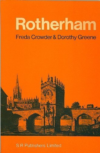
Rotherham: It's History, Church and Chapel on the Bridge
Sprache: Englisch
Verlag: S. R. Publishers, Wakefield, 1971
ISBN 10: 0854097171 ISBN 13: 9780854097173
Anbieter: George Longden, Macclesfield, Vereinigtes K÷nigreich
Verkõuferbewertung 5 von 5 Sternen
EUR 11,81
EUR 28,67 Versand
Versand von Vereinigtes K÷nigreich nach USAAnzahl: 1 verf³gbar
In den WarenkorbSoft cover. Zustand: Very Good. A little minor grubby marking at edges. 215 x 140 mm. [70 pp.] B&w illustrations.
-
ROTHERHAM Its History Church and Chapel on the Bridge
Anbieter: Richard Sylvanus Williams (Est 1976), WINTERTON, Vereinigtes K÷nigreich
Verkõuferbewertung 5 von 5 Sternen
Erstausgabe
EUR 8,18
EUR 34,40 Versand
Versand von Vereinigtes K÷nigreich nach USAAnzahl: 1 verf³gbar
In den WarenkorbCard. Zustand: nrFine. 1st Edition. About 60 pages. (2 copies).
-

Rotherham 1901: Yorkshire Sheet 289.11b (Old Ordnance Survey Maps of Yorkshire)
Anbieter: GENERATIONS GONE BY, Manchester, Vereinigtes K÷nigreich
Verkõuferbewertung 5 von 5 Sternen
Karte
EUR 3,25
EUR 34,92 Versand
Versand von Vereinigtes K÷nigreich nach USAAnzahl: 1 verf³gbar
In den WarenkorbNo Binding. Zustand: New. No Jacket. Here are the details of maps for Rotherham: Sheet 289.11a Rotherham 1890 - published 2013, intro by Melvyn Jones. ISBN.978-1-84784-694-5 Sheet 289.11b Rotherham 1901 - published 1984, 2nd edition 2020; intro by Freda Crowder, Sally Shepard & Alan Godfrey. ISBN.978-1-78721-360-9 Sheet 289.11c Rotherham 1922 - published 2004, intro by Melvyn Jones. ISBN.978-1-84151-698-1 We have published three versions of this detailed map, showing how the area developed across the years. The 1890 version is in colour, taken from the 1st edition OS handcoloured map. The maps cover the same area, with coverage stretching from Masbrough Street eastward to Western Road, and from Kenneth Street southward to Reneville Road. Rotherham town centre is covered and the many features include Central station, Westgate station, Workhouse, Rotherham Old Brewery, cattle market, River Don, Sheffield & South Yorkshire Navigation, hospital, All Saints church, Effingham Works, Rotherham Forge, Clifton Park, cholera burial ground, race course, Clifton House, Market Hall etc. Each map has selections from contemporary street directory entries. The map links up with Yorkshire Sheets 289.07 Eastwood to the north, 289.10 Masbrough to the west, 289.15 Rotherham South to the south.