Cyclopaedia (269 Ergebnisse)

Universal Cyclopaedia and Atlas Map of Central America- Original (1902)
Universal Cyclopaedia and Atlas; Adams, Charles Kendall (Ed.)
Sprache: Englisch
Verlag: D. Appleton and Company 1902
Anbieter: Imperial Books and Collectibles, Wauwatosa, WI, USAImperial Books and Collectibles
Verkäufer/-in kontaktierenVerkäufer/-in mit 5 SternenZustand: Gebraucht - Sehr gut
EUR 11,46
EUR 4,71 VersandVersand innerhalb von USAAnzahl: 1 verfügbar
No Binding. Zustand: Fine. This rare original hand colored map of Central America from Volume I of the 1902 edition of the acclaimed Universal Cyclopaedia and Atlas by D. Appleton and Company. This extraordinary example of 19th century map making depicts a snapshot of the political environment of Central America at the turn of t…he 20th century.Includes location of proposed Panama Canal. Plate size: 10" x 12" (25 x 30 cm) ; Margins: - Min 1/2 in (1.2 cm). Condition: Fine; central fold as issued.
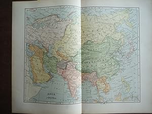
Universal Cyclopaedia and Atlas Map of Asia- Original (1902)
Bradley & Poates, Engrs.; Universal Cyclopaedia and Atlas; Adams, Charles Kendall (Ed.)
Sprache: Englisch
Verlag: D. Appleton and Company 1902
Anbieter: Imperial Books and Collectibles, Wauwatosa, WI, USAImperial Books and Collectibles
Verkäufer/-in kontaktierenVerkäufer/-in mit 5 SternenZustand: Gebraucht - Gut
EUR 11,46
EUR 4,71 VersandVersand innerhalb von USAAnzahl: 1 verfügbar
No Binding. Zustand: Very Good. This rare original hand colored map of Asia from Volume I of the 1902 edition of the acclaimed Universal Cyclopaedia and Atlas by D. Appleton and Company. This extraordinary example of 19th century map making depicts a snapshot of the political environment of Asia at the turn of the 20th century.…Plate size: 10" x 12" (25 x 30 cm) ; Margins: - Min 1/2 in (1.2 cm). Condition: Very Good; central fold as issued. Small closed tear along margin not affecting plate.
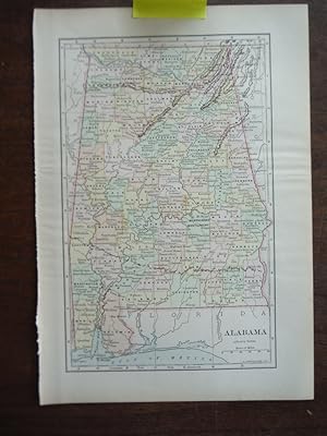
Universal Cyclopaedia and Atlas Map of Alabama - Original (1902)
Universal Cyclopaedia and Atlas; Adams, Charles Kendall (Ed.)
Sprache: Englisch
Verlag: D. Appleton and Company 1902
Anbieter: Imperial Books and Collectibles, Wauwatosa, WI, USAImperial Books and Collectibles
Verkäufer/-in kontaktierenVerkäufer/-in mit 5 SternenZustand: Gebraucht - Sehr gut
EUR 11,46
EUR 4,71 VersandVersand innerhalb von USAAnzahl: 1 verfügbar
No Binding. Zustand: Fine. This rare original hand colored map of Alabama is from Volume I of the 1902 edition of the acclaimed Universal Cyclopaedia and Atlas by D. Appleton and Company. Counties are distinguished by color. Cities, towns, roads and rail lines are clearly depicted. Plate size: - 9" x 6 3/4" (23 x 17 cm). Margins…: - Min 1/2in (1.2cm). Condition: Fine.

Universal Cyclopaedia and Atlas Map of Brooklyn (New York) - Original (1902)
Universal Cyclopaedia and Atlas; Adams, Charles Kendall (Ed.)
Sprache: Englisch
Verlag: D. Appleton and Company 1902
Anbieter: Imperial Books and Collectibles, Wauwatosa, WI, USAImperial Books and Collectibles
Verkäufer/-in kontaktierenVerkäufer/-in mit 5 SternenZustand: Gebraucht - Sehr gut
EUR 11,46
EUR 4,71 VersandVersand innerhalb von USAAnzahl: 1 verfügbar
No Binding. Zustand: Fine. This rare original hand colored map of the the Borough of Brooklyn, New York is from Volume II of the 1902 edition of the acclaimed Universal Cyclopaedia and Atlas by D. Appleton and Company. Streets, public buildings, colleges, hospitals, rail depots, hotels, theatres and churches are clearly identifi…ed. Plate size: - 9" x 12" (23 x 30 cm); Margins: - Min 1/2in (1.2 cm). Condition: Fine; central fold as issued. On obserse sides are engravings of the East River Bridge and the Approach to the East River Bridge (New York side).
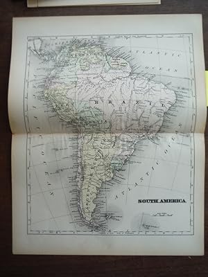
Universal Cyclopaedia and Atlas Map of South America - Original (1902)
Universal Cyclopaedia and Atlas; Adams, Charles Kendall (Ed.)
Sprache: Englisch
Verlag: D. Appleton and Company 1902
Anbieter: Imperial Books and Collectibles, Wauwatosa, WI, USAImperial Books and Collectibles
Verkäufer/-in kontaktierenVerkäufer/-in mit 5 SternenZustand: Gebraucht - Sehr gut
EUR 11,46
EUR 4,71 VersandVersand innerhalb von USAAnzahl: 1 verfügbar
No Binding. Zustand: Fine. This rare original hand colored map ofSouth America from Volume I of the 1902 edition of the acclaimed Universal Cyclopaedia and Atlas by D. Appleton and Company. This extraordinary example of 19th century mapmaking depicts a snapshot of the political landscape of the South American Continent at the tu…rn of the century. Plate size: - 12" x 10" (30 x 25 cm) ; Margins: - Min 1/2 in (1.2 cm). Condition: Fine; central fold as issued.
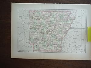
Universal Cyclopaedia and Atlas Map of Arkansas - Original (1902)
Universal Cyclopaedia and Atlas; Adams, Charles Kendall (Ed.)
Sprache: Englisch
Verlag: D. Appleton and Company 1902
Anbieter: Imperial Books and Collectibles, Wauwatosa, WI, USAImperial Books and Collectibles
Verkäufer/-in kontaktierenVerkäufer/-in mit 5 SternenZustand: Gebraucht - Sehr gut
EUR 11,46
EUR 4,71 VersandVersand innerhalb von USAAnzahl: 1 verfügbar
No Binding. Zustand: Fine. This rare original hand colored map of Arkansas is from Volume I of the 1902 edition of the acclaimed Universal Cyclopaedia and Atlas by D. Appleton and Company. Counties are distinguished by color. Cities, towns, roads and rail lines are clearly depicted. Plate size: - 6" x 9 " (15 x 23 cm). Margins:…- Min 1/2 in (1.2cm). Condition: Fine.

Universal Cyclopaedia and Atlas Map of Chicago (Illinois) - Original (1902)
Universal Cyclopaedia and Atlas; Adams, Charles Kendall (Ed.)
Sprache: Englisch
Verlag: D. Appleton and Company 1902
Anbieter: Imperial Books and Collectibles, Wauwatosa, WI, USAImperial Books and Collectibles
Verkäufer/-in kontaktierenVerkäufer/-in mit 5 SternenZustand: Gebraucht - Sehr gut
EUR 11,46
EUR 4,71 VersandVersand innerhalb von USAAnzahl: 1 verfügbar
No Binding. Zustand: Fine. This rare original hand colored map of the the City of Chicago, Illinois is from Volume II of the 1902 edition of the acclaimed Universal Cyclopaedia and Atlas by D. Appleton and Company. Streets, public buildings, colleges, hospitals, rail depots, rail lines, hotels, theatres and churches are clearly…identified. Plate size: - 9" x 12" (23 x 30 cm); Margins: - Min 1/4 in (0.6cm). Condition: Fine; Central fold, as issued. Pictures of the Fine Arts Building, World's Columbian Exposition and the University of Chicago principal building on the obverse sides.

Universal Cyclopaedia and Atlas Map of California Original (1902)
Universal Cyclopaedia and Atlas; Adams, Charles Kendall (Ed.)
Sprache: Englisch
Verlag: D. Appleton and Company 1902
Anbieter: Imperial Books and Collectibles, Wauwatosa, WI, USAImperial Books and Collectibles
Verkäufer/-in kontaktierenVerkäufer/-in mit 5 SternenZustand: Gebraucht - Sehr gut
EUR 11,46
EUR 4,71 VersandVersand innerhalb von USAAnzahl: 1 verfügbar
No Binding. Zustand: Fine. This rare original hand colored map of California is from Volume II of the 1902 edition of the acclaimed Universal Cyclopaedia and Atlas by D. Appleton and Company. Counties are distinguished by color. Cities, towns, roads and rail lines are clearly depicted. Plate size: - 11" x 9" (28 x 23 cm). Margin…s: - Min 1/2in (1.2cm). Condition: Fine; Central fold as issued.
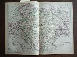
Universal Cyclopaedia and Atlas Map of Austria-Hungary- Original (1902)
Universal Cyclopaedia and Atlas; Adams, Charles Kendall (Ed.)
Sprache: Englisch
Verlag: D. Appleton and Company 1902
Anbieter: Imperial Books and Collectibles, Wauwatosa, WI, USAImperial Books and Collectibles
Verkäufer/-in kontaktierenVerkäufer/-in mit 5 SternenZustand: Gebraucht - Gut
EUR 11,46
EUR 4,71 VersandVersand innerhalb von USAAnzahl: 1 verfügbar
No Binding. Zustand: Very Good. This rare original hand colored map of Austria-Hungary from Volume I of the 1902 edition of the acclaimed Universal Cyclopaedia and Atlas by D. Appleton and Company. This extraordinary example of map making depicts a snapshot of the political environment of Austria-Hungary at the turn of the 20th…century. Plate size: 10" x 12" (25 x 30 cm) ; Margins: - Min 1/2 in (1.2 cm). Condition: Very Good; central fold as issued. Small closed tear along margin not affecting plate.
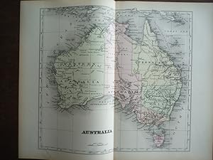
Universal Cyclopaedia and Atlas Map of Australia- Original (1902)
Universal Cyclopaedia and Atlas; Adams, Charles Kendall (Ed.)
Sprache: Englisch
Verlag: D. Appleton and Company 1902
Anbieter: Imperial Books and Collectibles, Wauwatosa, WI, USAImperial Books and Collectibles
Verkäufer/-in kontaktierenVerkäufer/-in mit 5 SternenZustand: Gebraucht - Gut
EUR 11,46
EUR 4,71 VersandVersand innerhalb von USAAnzahl: 1 verfügbar
No Binding. Zustand: Very Good. This rare original hand colored map of Australia from Volume I of the 1902 edition of the acclaimed Universal Cyclopaedia and Atlas by D. Appleton and Company. This extraordinary example of 19th century map making depicts a snapshot of the political environment of Australia at the turn of the 20th… century. Plate size: 10" x 12" (25 x 30 cm) ; Margins: - Min 1/2 in (1.2 cm). Condition: Very Good; central fold as issued. Small closed tear along margin not affecting plate.

Universal Cyclopaedia and Atlas Map of the Dominion of Canada - Original (1902)
Universal Cyclopaedia and Atlas; Adams, Charles Kendall (Ed.)
Sprache: Englisch
Verlag: D. Appleton and Company 1902
Anbieter: Imperial Books and Collectibles, Wauwatosa, WI, USAImperial Books and Collectibles
Verkäufer/-in kontaktierenVerkäufer/-in mit 5 SternenZustand: Gebraucht - Sehr gut
EUR 11,46
EUR 4,71 VersandVersand innerhalb von USAAnzahl: 1 verfügbar
No Binding. Zustand: Fine. This rare original hand colored map of the Dominion of Canada is from Volume II of the 1902 edition of the acclaimed Universal Cyclopaedia and Atlas by D. Appleton and Company. Plate size: 9 " x 12" (23 x 30.5 cm)- Margins: Min 1/2in. Condition: Fine; central fold as issued.

Johnson's Map of Kansas - Original (1895)
Johnson's Universal Cyclopaedia; Adams, Charles Kendall (Ed.)
Sprache: Englisch
Verlag: A. J. Johnson Company 1895
Anbieter: Imperial Books and Collectibles, Wauwatosa, WI, USAImperial Books and Collectibles
Verkäufer/-in kontaktierenVerkäufer/-in mit 5 SternenZustand: Gebraucht - Sehr gut
EUR 11,46
EUR 4,71 VersandVersand innerhalb von USAAnzahl: 1 verfügbar
No Binding. Zustand: Fine. This rare original hand colored copper plate engraved map of Kansas is from Volume IV of the 1895 edition of the acclaimed Johnson's Universal Cyclopaedia. Cities, towns, roads and rail lines are clearly depicted. Plate size: - 8.

Johnson's Map of Southern India - Original (1895)
Johnson's Universal Cyclopaedia; Adams, Charles Kendall (Ed.)
Sprache: Englisch
Verlag: A. J. Johnson Company 1895
Anbieter: Imperial Books and Collectibles, Wauwatosa, WI, USAImperial Books and Collectibles
Verkäufer/-in kontaktierenVerkäufer/-in mit 5 SternenZustand: Gebraucht - Sehr gut
EUR 11,46
EUR 4,71 VersandVersand innerhalb von USAAnzahl: 1 verfügbar
No Binding. Zustand: Fine. This rare original hand colored map of Southern India is from Volume IV of the 1895 edition the highly acclaimed Johnson's Universal Cyclopaedia. This map depicts a snapshot of the political landscape of Southern India at the dawn of the 20th Century Plate size: - 9" x 13" (23 x 33 cm) Margins: - Min 1…/8 in (1.2 cm). Condition: Fine; Central fold as issued.
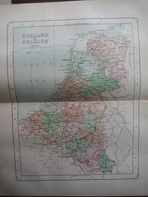
Johnson's Map of Holland & Belgium - Original (1895)
Johnson's Universal Cyclopaedia; Adams, Charles Kendall (Ed.)
Sprache: Englisch
Verlag: A. J. Johnson Company 1895
Anbieter: Imperial Books and Collectibles, Wauwatosa, WI, USAImperial Books and Collectibles
Verkäufer/-in kontaktierenVerkäufer/-in mit 5 SternenZustand: Gebraucht - Sehr gut
EUR 11,46
EUR 4,71 VersandVersand innerhalb von USAAnzahl: 1 verfügbar
No Binding. Zustand: Fine. This rare original hand colored copper engraved map of Holland and Belgium is from Volume IV of the 1895 edition the highly acclaimed Johnson's Universal Cyclopaedia. This map depicts a snapshot of the political landscape of Holland and Belgium at the dawn of the 20th Century. Plate size: - Size: 11" x… 8.

Johnson's Map of Illinois - Original (1895)
Johnson's Universal Cyclopaedia; Adams, Charles Kendall (Ed.)
Sprache: Englisch
Verlag: A. J. Johnson Company 1895
Anbieter: Imperial Books and Collectibles, Wauwatosa, WI, USAImperial Books and Collectibles
Verkäufer/-in kontaktierenVerkäufer/-in mit 5 SternenZustand: Gebraucht - Sehr gut
EUR 11,46
EUR 4,71 VersandVersand innerhalb von USAAnzahl: 1 verfügbar
No Binding. Zustand: Fine. This rare original hand colored copper plate engraving of Illinois is from Volume IV of the 1895 edition of the acclaimed Johnson's Universal Cyclopaedia. Cities, towns, roads and rail lines are clearly depicted. . Plate size: - 12" x 10" (30 x 25 cm); Margins: - Min 1/2 in (12.7 mm). Condition: Fine;…Central fold as issued.

Johnson's Map of the Hawaiian Islands - Original (1895)
Johnson's Universal Cyclopaedia; Adams, Charles Kendall (Ed.)
Sprache: Englisch
Verlag: A. J. Johnson Company 1895
Anbieter: Imperial Books and Collectibles, Wauwatosa, WI, USAImperial Books and Collectibles
Verkäufer/-in kontaktierenVerkäufer/-in mit 5 SternenZustand: Gebraucht - Sehr gut
EUR 11,46
EUR 4,71 VersandVersand innerhalb von USAAnzahl: 1 verfügbar
No Binding. Zustand: Fine. This rare original hand colored map of the Hawaiian Islands is from Volume IV of the 1895 edition of the acclaimed Johnson's Universal Cyclopaedia. Cities, towns, and geological features are clearly depicted. Included is an insert of Honolulu and Vicinity. Plate size: 5, about 6x9".

Johnson's Map of Japan - Original (1895)
Johnson's Universal Cyclopaedia; Adams, Charles Kendall (Ed.)
Sprache: Englisch
Verlag: A. J. Johnson Company 1895
Anbieter: Imperial Books and Collectibles, Wauwatosa, WI, USAImperial Books and Collectibles
Verkäufer/-in kontaktierenVerkäufer/-in mit 5 SternenZustand: Gebraucht - Gut
EUR 11,46
EUR 4,71 VersandVersand innerhalb von USAAnzahl: 1 verfügbar
No Binding. Zustand: Very Good. : This rare original hand colored map of Japan is from Volume IV of the 1895 edition the highly acclaimed Johnson's Universal Cyclopaedia. This map depicts a snapshot of the political landscape of Japan at the dawn of the 20th Century and includes detail geological features. It also contains small… inset maps of Kurile Islands and Loochoo Islands. Plate size: - 9.

Johnson's Map of Iowa - Original (1895)
Johnson's Universal Cyclopaedia; Adams, Charles Kendall (Ed.)
Sprache: Englisch
Verlag: A. J. Johnson Company 1895
Anbieter: Imperial Books and Collectibles, Wauwatosa, WI, USAImperial Books and Collectibles
Verkäufer/-in kontaktierenVerkäufer/-in mit 5 SternenZustand: Gebraucht - Sehr gut
EUR 11,46
EUR 4,71 VersandVersand innerhalb von USAAnzahl: 1 verfügbar
No Binding. Zustand: Fine. This rare original hand colored copper plate engraved map of Iowa is from Volume IV of the 1895 edition of the acclaimed Johnson's Universal Cyclopaedia. Cities, towns, roads and rail lines are clearly depicted. Plate size: - 8 about 12x9" center fold as issued.
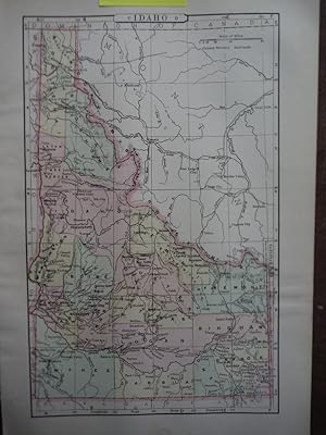
Johnson's Map of Idaho - Original (1895)
Johnson's Universal Cyclopaedia; Adams, Charles Kendall (Ed.)
Sprache: Englisch
Verlag: A. J. Johnson Company 1895
Anbieter: Imperial Books and Collectibles, Wauwatosa, WI, USAImperial Books and Collectibles
Verkäufer/-in kontaktierenVerkäufer/-in mit 5 SternenZustand: Gebraucht - Sehr gut
EUR 11,46
EUR 4,71 VersandVersand innerhalb von USAAnzahl: 1 verfügbar
No Binding. Zustand: Fine. This rare original hand colored lithographic map of Idaho is from Volume IV of the 1897 edition of the acclaimed Johnson's Universal Cyclopaedia. Counties are distinguished by color. Cities, towns, roads and railroads are clearly depicted. Plate size: - 9" X 6.
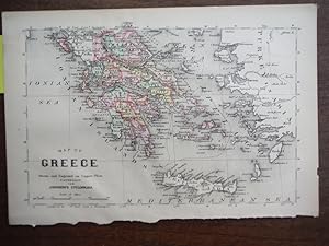
Johnson's Map of Greece - Original (1895)
Johnson's Universal Cyclopaedia; Adams, Charles Kendall (Ed.)
Sprache: Englisch
Verlag: A. J. Johnson Company 1895
Anbieter: Imperial Books and Collectibles, Wauwatosa, WI, USAImperial Books and Collectibles
Verkäufer/-in kontaktierenVerkäufer/-in mit 5 SternenZustand: Gebraucht - Sehr gut
EUR 11,46
EUR 4,71 VersandVersand innerhalb von USAAnzahl: 1 verfügbar
No Binding. Zustand: Fine. This rare original hand colored copper plate engraved map of Greece is from Volume IV of the 1895 edition the highly acclaimed Johnson's Universal Cyclopaedia. This map depicts a snapshot of the political landscape of Greece at the dawn of the 20th Century. Plate size: 6" x 9 1/4" (15 x 23.5 cm) ; Marg…ins: - Min 1/2in (1.2 cm). Condition: Fine.

Johnson's Map of Indiana - Original (1895)
Johnson's Universal Cyclopaedia; Adams, Charles Kendall (Ed.)
Sprache: Englisch
Verlag: A. J. Johnson Company 1895
Anbieter: Imperial Books and Collectibles, Wauwatosa, WI, USAImperial Books and Collectibles
Verkäufer/-in kontaktierenVerkäufer/-in mit 5 SternenZustand: Gebraucht - Sehr gut
EUR 11,46
EUR 4,71 VersandVersand innerhalb von USAAnzahl: 1 verfügbar
No Binding. Zustand: Fine. This rare original hand colored copper plate engraving of Indiana is from Volume IV of the 1895 edition of the acclaimed Johnson's Universal Cyclopaedia. Cities, towns, roads and rail lines are clearly depicted. . Plate size: - 12" x 10" (30 x 25 cm); Margins: - Min 1/2 in (12.7 mm). Condition: Fine; C…entral fold as issued.
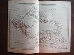
Johnson's Map of West Indies and Central America - Original (1895)
Johnson's Universal Cyclopaedia; Adams, Charles Kendall (Ed.)
Sprache: Englisch
Verlag: A. J. Johnson Company 1895
Anbieter: Imperial Books and Collectibles, Wauwatosa, WI, USAImperial Books and Collectibles
Verkäufer/-in kontaktierenVerkäufer/-in mit 5 SternenZustand: Gebraucht - Gut
EUR 11,46
EUR 4,71 VersandVersand innerhalb von USAAnzahl: 1 verfügbar
No Binding. Zustand: Very Good. This rare original hand colored map of the West Indies and Central America is from Volume VIII of the 1895 edition the highly acclaimed Johnson's Universal Cyclopaedia. This map depicts a snapshot of the political landscape of the West Indies and Central America just prior to the Spanish-American…War. T. Plate size: - 10" x 12" (25 x 30 cm); Margins: - Min 1/2in (1.2 cm). Condition: Very Good; light soiling along margins. Central fold, as issued.
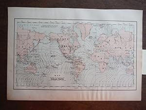
Johnson's Map Showing the Course of the Tidal Wave on Three Great Oceans - Original (1895)
Johnson's Universal Cyclopaedia; Adams, Charles Kendall (Ed.)
Sprache: Englisch
Verlag: A. J. Johnson Company 1895
Anbieter: Imperial Books and Collectibles, Wauwatosa, WI, USAImperial Books and Collectibles
Verkäufer/-in kontaktierenVerkäufer/-in mit 5 SternenZustand: Gebraucht - Sehr gut
EUR 11,46
EUR 4,71 VersandVersand innerhalb von USAAnzahl: 1 verfügbar
No Binding. Zustand: Fine. This rare colored Map of the World Showing the the Course of the Tidal Wave on Three Great Oceans is from Volume VIII of the 1895 edition the highly acclaimed Johnson's Universal Cyclopaedia. Plate size: 5, about 5.5x10".

Johnson's Map of Vienna - Original (1895)
Johnson's Universal Cyclopaedia; Adams, Charles Kendall (Ed.)
Sprache: Englisch
Verlag: A. J. Johnson Company 1895
Anbieter: Imperial Books and Collectibles, Wauwatosa, WI, USAImperial Books and Collectibles
Verkäufer/-in kontaktierenVerkäufer/-in mit 5 SternenZustand: Gebraucht - Sehr gut
EUR 11,46
EUR 4,71 VersandVersand innerhalb von USAAnzahl: 1 verfügbar
No Binding. Zustand: Fine. This rare original colored map of the city of Vienna, Austria is from Volume VIII of the 1895 edition of the acclaimed Johnson's Universal Cyclopaedia. Streets, public buildings, colleges, hospitals, rail depots, rail lines, hotels, theatres and churches are clearly identified. This remarkable example…of 19th century mapmaking depicts this World Capital of Music at the height of its political influence as a capital of the Austro-Hungarian Empire. Plate size: 9" x 12" (23 x 30 cm); Min.

Johnson's Map of Washington (D.C.) - Original (1895)
Johnson's Universal Cyclopaedia; Adams, Charles Kendall (Ed.)
Sprache: Englisch
Verlag: A. J. Johnson Company 1895
Anbieter: Imperial Books and Collectibles, Wauwatosa, WI, USAImperial Books and Collectibles
Verkäufer/-in kontaktierenVerkäufer/-in mit 5 SternenZustand: Gebraucht - Sehr gut
EUR 11,46
EUR 4,71 VersandVersand innerhalb von USAAnzahl: 1 verfügbar
No Binding. Zustand: Fine. This rare original colored map of the city of Washington, D.C. is from Volume VIII of the 1895 edition of the acclaimed Johnson's Universal Cyclopaedia. Streets, public buildings, colleges, hospitals, rail depots, rail lines, hotels, theatres and churches are clearly identified. Plate size: 9" x 12" (2…3 x 30 cm); Min.
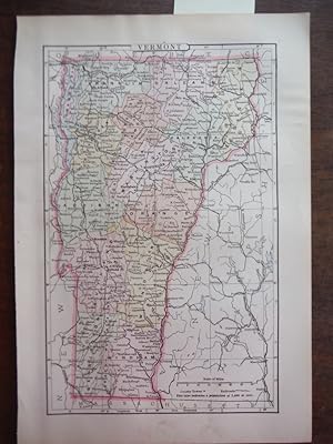
Johnson's Map of Vermont - Original (1895)
Johnson's Universal Cyclopaedia; Adams, Charles Kendall (Ed.)
Sprache: Englisch
Verlag: A. J. Johnson Company 1895
Anbieter: Imperial Books and Collectibles, Wauwatosa, WI, USAImperial Books and Collectibles
Verkäufer/-in kontaktierenVerkäufer/-in mit 5 SternenZustand: Gebraucht - Sehr gut
EUR 11,46
EUR 4,71 VersandVersand innerhalb von USAAnzahl: 1 verfügbar
No Binding. Zustand: Fine. This rare original hand colored lithographic map of Vermont is from Volume VIII of the 1895 edition of the acclaimed Johnson's Universal Cyclopaedia. Counties are distinguished by color. Cities, towns, roads and rail lines are clearly depicted. Plate size: - 9" x 5.

Johnson's Map of Delaware, Maryland, Virginia and West Virginia - Original (1895)
Johnson's Universal Cyclopaedia; Adams, Charles Kendall (Ed.)
Sprache: Englisch
Verlag: A. J. Johnson Company 1895
Anbieter: Imperial Books and Collectibles, Wauwatosa, WI, USAImperial Books and Collectibles
Verkäufer/-in kontaktierenVerkäufer/-in mit 5 SternenZustand: Gebraucht - Sehr gut
EUR 11,46
EUR 4,71 VersandVersand innerhalb von USAAnzahl: 1 verfügbar
No Binding. Zustand: Fine. This rare original hand colored copper engraved map of Delaware, Maryland, Virginia and West Virginia is from Volume VIII of the 1895 edition the highly acclaimed Johnson's Universal Cyclopaedia. Counties are distinguished by color. Cities, towns, roads and rail lines are clearly depicted. Included as…an inset is a small map of Galveston Bay and Vicinity. - Plate size: - 9" x 12" (23 x 30 cm) ; Margins: - Min 0.5 in (22.8 mm). Condition: Fine. Central fold, as issued.
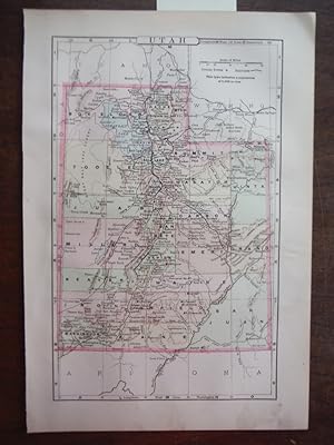
Johnson's Map of Utah - Original (1895)
Johnson's Universal Cyclopaedia; Adams, Charles Kendall (Ed.)
Sprache: Englisch
Verlag: A. J. Johnson Company 1895
Anbieter: Imperial Books and Collectibles, Wauwatosa, WI, USAImperial Books and Collectibles
Verkäufer/-in kontaktierenVerkäufer/-in mit 5 SternenZustand: Gebraucht - Sehr gut
EUR 11,46
EUR 4,71 VersandVersand innerhalb von USAAnzahl: 1 verfügbar
No Binding. Zustand: Fine. This rare original hand colored lithographic map of Utah is from Volume VIII of the 1895 edition of the acclaimed Johnson's Universal Cyclopaedia. Counties are distinguished by color. Cities, towns, roads and rail lines are clearly depicted. Plate size: - 9" x 5.
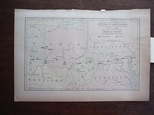
Universal Cyclopaedia and Atlas Map Showing the Position of the Center of Population at the close of each Decade from 1790 to 1900 and the Location of the Median Point in 1880, 1890 and 1900- Original (1902)
Universal Cyclopaedia and Atlas; Adams, Charles Kendall (Ed.)
Sprache: Englisch
Verlag: D. Appleton and Company 1902
Anbieter: Imperial Books and Collectibles, Wauwatosa, WI, USAImperial Books and Collectibles
Verkäufer/-in kontaktierenVerkäufer/-in mit 5 SternenZustand: Gebraucht - Sehr gut
EUR 11,46
EUR 4,71 VersandVersand innerhalb von USAAnzahl: 1 verfügbar
No Binding. Zustand: Fine. This rare hand colored Map Showing the Position of the Center of Population at the close of each Decade from 1790 to 1900 and the Location of the Median Point in 1880, 1890 and 1900 is from Volume XII of the 1902 edition the highly acclaimed Universal Cyclopaedia and Atlas. Plate size: 5.75" x 9.75" (1…4.6 x 24.8 cm; Margins: Minimum 1/2" (1.3 cm). Condition: Fine.
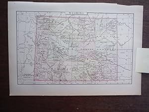
Universal Cyclopaedia and Atlas Map of Wyoming - Original (1902)
Universal Cyclopaedia and Atlas; Adams, Charles Kendall (Ed.)
Sprache: Englisch
Verlag: D. Appleton and Company 1902
Anbieter: Imperial Books and Collectibles, Wauwatosa, WI, USAImperial Books and Collectibles
Verkäufer/-in kontaktierenVerkäufer/-in mit 5 SternenZustand: Gebraucht - Sehr gut
EUR 11,46
EUR 4,71 VersandVersand innerhalb von USAAnzahl: 1 verfügbar
No Binding. Zustand: Fine. This rare original hand colored lithographic map of Wyoming is from Volume XII of the 1902 edition of the acclaimed Universal Cyclopaedia and Atlas Counties are distinguished by color. Cities, towns, roads, rail lines and geographical features are clearly depicted. n. Plate size: - 6 about 6x9".


