Gesamtpreis (1 Artikel Artikel):
Versandziel:

danville santini (19 Ergebnisse)
Direkt zu den wichtigsten Suchergebnissen
Produktart
- Alle Produktarten
- Bücher (1)
- Magazine & Zeitschriften
- Comics
- Noten
- Kunst, Grafik & Poster (6)
- Fotografien
- Karten (12)
-
Manuskripte &
Papierantiquitäten
Zustand
- Alle
- Neu
- Antiquarisch/Gebraucht
Einband
- alle Einbände
- Hardcover
- Softcover
Weitere Eigenschaften
- Erstausgabe
- Signiert
- Schutzumschlag
- Angebotsfoto (14)
- Kein Print-on-Demand
Land des Verkäufers
Verkäuferbewertung
-
Carte de la Guinee Contenant les Isles du Cap Verd, le Senegal, la Cote de Guinee Proprement Dite, les Royaumes de Loango, Congo, Angola et Benguela." - West Africa Afrique Guinea Sierra Leone Ghana Liberia Cote d'Ivoire Senegal Gambia Togo Benin Nigeria Cameroon Congo Gabon
Verlag: Venezia, Santini & Remondini, 1779
Anbieter: Antiquariat Steffen Völkel GmbH, Seubersdorf, Deutschland
Bewertung:

Karte
Großformatige altkolorierte Kupferstich-Karte von 1779. Auf starkem Papier gedruckt. -- Blatt-Maße: ca. 52 x 74 cm. -- sehr gut erhalten. || Large old colored engraved map from 1779. Printed on strong paper. -- in very good condition. || Francesco Santini was a Venetian publisher. He acquired the printing plates of Vaugondy's Atlas Universel, a commercial and cartographic success, with widespread influence on mapmakers throughout Europe. Together with his brother Paolo, he commissioned a new set of plates and reissued the atlas in 1776. In the following years, Paolo Santini assigned all his publication rights to M. Remondini, who in 1777 reissued the same atlas, but with his name. || Dies ist ein Original! - Kein Nachdruck! - Keine Kopie! -- This is an original! - No copy! - No reprint! Sprache: Französisch Gewicht in Gramm: 550.
-
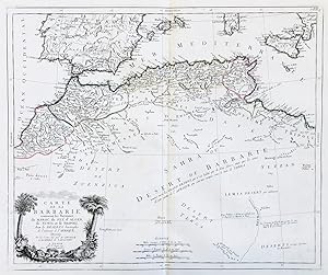
Carte de la Barbarie contenant les Royaumes de Maroc, de Fez, d'Alger, de Tunis et de Tripoli, avec les Deserts limitrophes de l'interieur de l'Afrique" - Northern Africa Morocco Tunisia Algeria Maroc Marokko Tunisien Tunesien Algerie Algerien Afrika Afrique
Verlag: Venezia, Santini & Remondini, 1775
Anbieter: Antiquariat Steffen Völkel GmbH, Seubersdorf, Deutschland
Bewertung:
Karte
Großformatige altkolorierte Kupferstich-Karte von 1775 -- Blatt-Maße: ca. 52 x 74 cm. -- sehr gut erhalten. || Large old colored engraved map from 1775. -- in very good condition. || Francesco Santini was a Venetian publisher. He acquired the printing plates of Vaugondy's Atlas Universel, a commercial and cartographic success, with widespread influence on mapmakers throughout Europe. Together with his brother Paolo, he commissioned a new set of plates and reissued the atlas in 1776. In the following years, Paolo Santini assigned all his publication rights to M. Remondini, who in 1777 reissued the same atlas, but with his name. || Dies ist ein Original! - Kein Nachdruck! - Keine Kopie! -- This is an original! - No copy! - No reprint! Sprache: Französisch Gewicht in Gramm: 550.
-
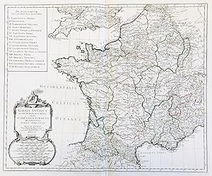
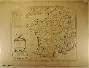
Gallia Antiqua ex Aevi Romani Monumentis Eruta et Ser:mi Carnutum Ducis Munificentia Publici Juris Facta" - France Gaule Gallia Gallien Frankreich carte gravure
Verlag: Venezia, Santini & Remondini ca. 1777., 1777
Anbieter: Antiquariat Steffen Völkel GmbH, Seubersdorf, Deutschland
Bewertung:
Karte
Großformatige altkolorierte Kupferstich-Karte von c. 1777. -- Blatt-Maße: ca. 52 x 74 cm. -- gut erhalten. || Large old colored engraved map from c. 1777. -- in good condition. || Francesco Santini was a Venetian publisher. He acquired the printing plates of Vaugondy's Atlas Universel, a commercial and cartographic success, with widespread influence on mapmakers throughout Europe. Together with his brother Paolo, he commissioned a new set of plates and reissued the atlas in 1776. In the following years, Paolo Santini assigned all his publication rights to M. Remondini, who in 1777 reissued the same atlas, but with his name. || Dies ist ein Original! - Kein Nachdruck! - Keine Kopie! -- This is an original! - No copy! - No reprint! la Gewicht in Gramm: 550.
-
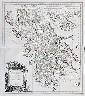
Graeciae Antiquae Specimen Geographicum in quo Macedonia, Thessalis, Epirus, Achaia et Peloponnesus in minores partes seu populos distinguuntur" - Greece Griechenland Peloponnese
Verlag: Venezia, Santini & Remondini, 1778
Anbieter: Antiquariat Steffen Völkel GmbH, Seubersdorf, Deutschland
Bewertung:
Karte
Großformatige altkolorierte Kupferstich-Karte von 1778. Auf starkem Papier gedruckt. -- Blatt-Maße: ca. 74 x 52 cm. -- sehr gut erhalten. || Large old colored engraved map from 1778. Printed on strong paper. -- in very good condition. || Francesco Santini was a Venetian publisher. He acquired the printing plates of Vaugondy's Atlas Universel, a commercial and cartographic success, with widespread influence on mapmakers throughout Europe. Together with his brother Paolo, he commissioned a new set of plates and reissued the atlas in 1776. In the following years, Paolo Santini assigned all his publication rights to M. Remondini, who in 1777 reissued the same atlas, but with his name. || Dies ist ein Original! - Kein Nachdruck! - Keine Kopie! -- This is an original! - No copy! - No reprint! Sprache: Französisch Gewicht in Gramm: 550.
-
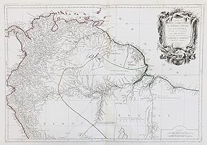
Carte du Perou et Bresil Sep. de Tierra-Firme, de Guayana, et de la Riviere des Amazones; ce qui fait la partie Boreale de l'Amerique Meridion.le" - Ecuador Colombia Venezuela Guyana Brazil Peru South America Amerika Brasilien Kolumbien
Verlag: Venezia, Santini & Remondini, 1779
Anbieter: Antiquariat Steffen Völkel GmbH, Seubersdorf, Deutschland
Bewertung:
Karte
Großformatige altkolorierte Kupferstich-Karte von 1779. Auf starkem Papier gedruckt. -- Blatt-Maße: ca. 52 x 74 cm. -- sehr gut erhalten. || Large old colored engraved map from 1779. Printed on strong paper. -- in very good condition. || Francesco Santini was a Venetian publisher. He acquired the printing plates of Vaugondy's Atlas Universel, a commercial and cartographic success, with widespread influence on mapmakers throughout Europe. Together with his brother Paolo, he commissioned a new set of plates and reissued the atlas in 1776. In the following years, Paolo Santini assigned all his publication rights to M. Remondini, who in 1777 reissued the same atlas, but with his name. || Dies ist ein Original! - Kein Nachdruck! - Keine Kopie! -- This is an original! - No copy! - No reprint! Sprache: Französisch Gewicht in Gramm: 550.
-
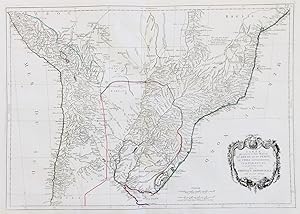
Carte qui representé la Partie Meridionale du Bresil et du Perou, le Chili Septentrional, et le Paraguay, ce qui fait la Partie de milieu de l'Amerique Meridionale" - Brazil Bolivia Paraguay Peru Chile South America Amerika Brasilien Bolivien
Verlag: Venezia, Santini & Remondini, 1779
Anbieter: Antiquariat Steffen Völkel GmbH, Seubersdorf, Deutschland
Bewertung:
Karte
Großformatige altkolorierte Kupferstich-Karte von 1779. Auf starkem Papier gedruckt. -- Blatt-Maße: ca. 52 x 74 cm. -- sehr gut erhalten. || Large old colored engraved map from 1779. Printed on strong paper. -- in very good condition. || Francesco Santini was a Venetian publisher. He acquired the printing plates of Vaugondy's Atlas Universel, a commercial and cartographic success, with widespread influence on mapmakers throughout Europe. Together with his brother Paolo, he commissioned a new set of plates and reissued the atlas in 1776. In the following years, Paolo Santini assigned all his publication rights to M. Remondini, who in 1777 reissued the same atlas, but with his name. || Dies ist ein Original! - Kein Nachdruck! - Keine Kopie! -- This is an original! - No copy! - No reprint! Sprache: Französisch Gewicht in Gramm: 550.
-

Orbis Veteribus Notus auspiciis Serenissimi Prinicipus Ludovici Philippi Aurelianorum Ducis Publici Juris Factus" - Old World Map Weltkarte Mappemonde
Verlag: Venezia, Santini & Remondini c. 1779., 1779
Anbieter: Antiquariat Steffen Völkel GmbH, Seubersdorf, Deutschland
Bewertung:
Karte
Großformatige altkolorierte Kupferstich-Karte von c. 1779. Auf starkem Papier gedruckt. -- Blatt-Maße: ca. 52 x 74 cm. -- sehr gut erhalten. || Large old colored engraved map from c. 1779. Printed on strong paper. -- in very good condition. || Francesco Santini was a Venetian publisher. He acquired the printing plates of Vaugondy's Atlas Universel, a commercial and cartographic success, with widespread influence on mapmakers throughout Europe. Together with his brother Paolo, he commissioned a new set of plates and reissued the atlas in 1776. In the following years, Paolo Santini assigned all his publication rights to M. Remondini, who in 1777 reissued the same atlas, but with his name. || Dies ist ein Original! - Kein Nachdruck! - Keine Kopie! -- This is an original! - No copy! - No reprint! Sprache: Französisch Gewicht in Gramm: 550.
-

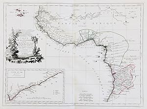
Afrique publiée sous les Auspices de Monseigneur le Duc d'Orleans Premier Prince du Sang" - Northern Africa Afrika Afrique continent Kontinent
Verlag: Venezia, Santini & Remondini ca. 1779., 1779
Anbieter: Antiquariat Steffen Völkel GmbH, Seubersdorf, Deutschland
Bewertung:
Karte
Großformatige altkolorierte Kupferstich-Karte von ca. 1779. Von 2 Platten gedruckt. -- Der obere Teil einer von 4 Platten gedruckten Afrika-Karte. -- Blatt-Maße: ca. 52 x 105 cm. -- im oberen Rand leicht fleckig, sonst sehr gut erhalten. || Large old colored engraved map from ca. 1779. Printed on two plates. -- Consitutes the upper part of a map of Africa printed on 4 plates. -- slightly stained on the upper margin, otherwise in very good condition. || Francesco Santini was a Venetian publisher. He acquired the printing plates of Vaugondy's Atlas Universel, a commercial and cartographic success, with widespread influence on mapmakers throughout Europe. Together with his brother Paolo, he commissioned a new set of plates and reissued the atlas in 1776. In the following years, Paolo Santini assigned all his publication rights to M. Remondini, who in 1777 reissued the same atlas, but with his name. || Dies ist ein Original! - Kein Nachdruck! - Keine Kopie! -- This is an original! - No copy! - No reprint! Sprache: Französisch Gewicht in Gramm: 550.
-

Carte de l'Empire de Perse.
Verlag: Remondini,, Venezia,, 1779
Anbieter: libreria antiquaria perini Sas di Perini, Verona, VR, Italien
Bewertung:
Kunst / Grafik / Poster
Incisione in rame, colorata d'epoca ai confini, di mm 480x610, bel cartiglio figurato. Tratta da "Atlas Universel" stampato a Venezia fra il 1776 ed il 1784. Buon esemplare con ampi margini, presenti aloni di umidit? marginali.
-
La Palestine les Tribus, et Jerusalem.
Verlag: Remondini,, Venezia,, 1783
Anbieter: libreria antiquaria perini Sas di Perini, Verona, VR, Italien
Bewertung:
Kunst / Grafik / Poster
Incisione in rame, colorata d'epoca ai confini, di mm 420x550. Bella mappa della Palestina da entrambi i lati del Giordano, la linea di costa che parte da Sidone a Rhinocorura (El-Harish). Comprende 3 mappe dettagliate dentro i riquadri, due in alto e uno in basso che rappresentano Gerusalemme, le Trib? e le localit? previste dal distanze indicate in scalaridotta di un terzo. Bel cartiglio in alto a destra. Tratta da "Atlas Universel" stampato a Venezia fra il 1776 ed il 1784. Buon esemplare con ampi margini, presenti aloni di umidit? all'esterno del m.
-

L'Italie Publiée sous les Auspices de Monseigneur le Duc d'Orleans Premier Prince du Sang" - Italia Italy Italien Sicilia Sardegna Corsica Corse Sardinia Sicily carta incisione
Verlag: Venezia, Santini & Remondini ca. 1779., 1779
Anbieter: Antiquariat Steffen Völkel GmbH, Seubersdorf, Deutschland
Bewertung:
Karte
Großformatige altkolorierte Kupferstich-Karte von ca. 1779. Von 4 Platten gedruckt und zusammengesetzt. -- Blatt-Maße: ca. 91 x 70 cm. -- mit hinterlegtem Randeinriss bis ins Bild auf der linken Seite, sonst sehr gut erhalten. || Rare large wall map of Italy. Old colored engraved map from c. 1779. Printed on 4 plates and joined together. -- with a deposited marginal tear on the left, otherwise in very good condition. || Francesco Santini was a Venetian publisher. He acquired the printing plates of Vaugondy's Atlas Universel, a commercial and cartographic success, with widespread influence on mapmakers throughout Europe. Together with his brother Paolo, he commissioned a new set of plates and reissued the atlas in 1776. In the following years, Paolo Santini assigned all his publication rights to M. Remondini, who in 1777 reissued the same atlas, but with his name. || Dies ist ein Original! - Kein Nachdruck! - Keine Kopie! -- This is an original! - No copy! - No reprint! Sprache: Französisch Gewicht in Gramm: 550.
-
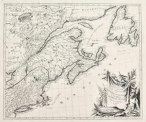
Partie Orientale du Canada avec la Nouvelle Angleterre, l'Acadie et la Terre-neuve
Verlag: Venezia, 1776
Anbieter: libreria antiquaria perini Sas di Perini, Verona, VR, Italien
Bewertung:
Kunst / Grafik / Poster
Incisione in rame, dipinta a mano d'epoca ai confini, mm 493x585. Tratta da "Atlas Universel" stampato a Venezia fra il 1776 ed il 1784. Ottimo esemplare con tracce marginali di umidit? Nr.cat: PB250003.
-
Gallia Antiqua ex Aevi Romani Monumentis Eruta et Ser.mi Carnutum Ducis Munifcientia Publicis iuris facta.
Verlag: Venezia: Francesco Santini, a Santa Giustina, 1760
Kunst / Grafik / Poster
Incisione su rame all'acquaforte e bulino in due fogli incollati di mm 572 x 482. Bella vergata veneziana. Filigrana AS. Foglio a larghi margini in candida e spessa carta di filo veneziana. Titolo entro ricco cartiglio in alto a destra. Elenco delle province antiche. Toponimi e descrizioni geografiche nella mappa. Proveniente da: "Atlas universel dressé sur les meilleures cartes modernes", Venezia 1776 (ma 1760). Gli Atlanti stampati da Francesco Santini, che, come indicato spesso nelle carte, teneva bottega a Santa Giustina, nel Sestiere di Castello, riutilizzano le lastre incise da Lattrč e disegnate da Janvier per l' "Atlas Moderne" stampato a Parigi nel 1771. L'Atlante di Janvier ebbe un immediato apprezzamento, sia per la precisione geografica, che per i ricchi cartigli molto decorativi. Robert (Jean) Janvier: working in Paris in the second half of the eighteenth century, Jean Janvier (1746 1776) produced a series of maps in the later half of the century. While there is some confusion about his Christian name, his maps usually were inscribed "Le Sieur Janvier". He is best known for his collaboration with engraver Jean Lattre for an Atlas Moderne first released in 1762 and in several later editions some by C. F. Delamarche and by Chez Remondini. He also produced several maps used in general atlases by William Fadan and P. Santini. 18mo secolo.
-
Carte du Mexique et de la Nouvelle Espagne.
Verlag: Remondini,, Venezia,, 1779
Anbieter: libreria antiquaria perini Sas di Perini, Verona, VR, Italien
Bewertung:
Kunst / Grafik / Poster
Incisione in rame, colorata, 452x585. Tratta da "Atlas Universel" stampato a Venezia fra il 1776 ed il 1784. Esemplare perfetto. Copperplate, coloured, 452x585. From "Atlas universel" printed in 1776-84. Perfect example. Nr.cat: 31.
-
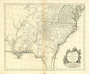
Partie Meridionale de la Louisiane avec la Floride la Caroline et la Virginie
Verlag: Luisiana - Florida - Virginia
Anbieter: Sergio Trippini, Gavirate, Italien
Bewertung:
Interessante raffigurazione di buona parte orientale degli Stati Uniti. Si trovano raffigurati i territori di New Jersey, Delaware, Maryland, Virginie, Caroline, Georgie, Floride e Louisiane.Il titolo č iscritto in decorativo cartiglio nell'angolo in basso a destra.Coloritura confinale coeva all'acquerello. Alcuni segni del tempo che non compromettono l'ottimale stato di conservazione generale della carta.
-
Carte gČnČrale du Canada, de la Louisiane, de la Floride, de la Caroline, de la Virginie, de la Nouvelle Angleterre etc.
Verlag: Venezia, 1776
Anbieter: libreria antiquaria perini Sas di Perini, Verona, VR, Italien
Bewertung:
Kunst / Grafik / Poster
Incisione in rame, dipinta a mano d'epoca ai confini, mm. 665x490. Tratta da "Atlas Universel" stampato a Venezia fra il 1776 ed il 1784. Ottimo esemplare. Nr.cat: 100-6880.
-
Partie Meridionale de la Louisiane avec la Floride, la Caroline, et la Virginie
Verlag: P. Santini c. 1776, Venice, 1776
Anbieter: Alexandre Antique Prints, Maps & Books, Toronto, ON, Kanada
Bewertung:

Karte
Zustand: Very Good. This decorative map of the south-east focuses on Carolina and Florida, but the area covered is from Delaware Bay to Cape Canaveral. Here \"Floride\" covers all of Georgia and some parts of Alabama. There is much detail along the Gulf coast as far west as New Orleans.From \"Santini Atlas Universel\"The map shows Indian Tribes, mountains, rivers, towns, forts ., Size : 490x580 (mm), 19.29x22.83 (Inches), Hand Colored in Outline, 0.
-
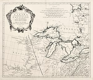
Carte Generale du Canada, de la Louisiane, de la Floride, de la Caroline, de la Virginie, de la Nouvelle Angleterre.
Verlag: Venice, 1776
Anbieter: Alexandre Antique Prints, Maps & Books, Toronto, ON, Kanada
Bewertung:
Karte
Zustand: Very Good. Map showing the Great Lakes and the entire eastern North America. An inset map showing Arctic region of Canada (the Hudson Bay and Baffin Bay) and Greenland., Size : 487x664 (mm), 19.17x26.14 (Inches), Original Outline Coloring.
-
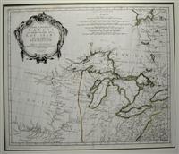
Partie Occidentale du Canada et Septentrionale de la Louisiane avec une partie de la Pensilvanie
Verlag: Venice, 1775
Anbieter: Alexandre Antique Prints, Maps & Books, Toronto, ON, Kanada
Bewertung:
Karte
Zustand: Excellent. Fine copper engraved map of the Great Lakes region with numerous place and Indian names. It is based on D'Anville's influential map of North America (1746). The map extends from the upper Mississippi River valley east to include most of Lake Ontario, north to James Bay and southeast to Philadelphia. Chicagon (Chicago) and Detroit are both located. Green Bay in present-day Wisconsin is named Bay des.Second State., Size : 490x570 (mm), 19.25x22.375 (Inches), Hand Colored in outline., 0.