Gesamtpreis (1 Artikel Artikel):
Versandziel:

edward wells sutton nicholls (2 Ergebnisse)
Direkt zu den wichtigsten Suchergebnissen
Produktart
- Alle Produktarten
- Bücher
- Magazine & Zeitschriften
- Comics
- Noten
- Kunst, Grafik & Poster
- Fotografien
- Karten (2)
-
Manuskripte &
Papierantiquitäten
Zustand
- Alle
- Neu
- Antiquarisch/Gebraucht
Einband
- alle Einbände
- Hardcover
- Softcover
Weitere Eigenschaften
- Erstausgabe
- Signiert
- Schutzumschlag
- Angebotsfoto
- Kein Print-on-Demand
Land des Verkäufers
Verkäuferbewertung
-
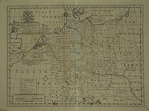
A New Map Of Antient Germany, Rhćtia, Vindelicia, and Noricum. Shewing their Principal People, Tribes, Cities, Towns, Rivers, Mountains, &c.
Verlag: Oxford -38, 1701
Anbieter: Robert Frew Ltd. ABA ILAB, London, Vereinigtes Königreich
Verbandsmitglied: ABA ILAB PBFA
Bewertung:

Karte
36 x 48.5 cm. Uncoloured. Double page historical map of Germany and central Europe. Tilte and dedication cartouche to upper left corner. Blank on verso. Light browning overall. A few spots scattered across sheet, two small brown stains at lower border.
-
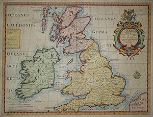
A New Map of the Brittish Isles. Shewing their Antient People, Cities, and Towns of Note, in the time of the Romans
Erscheinungsdatum: 1701
Karte
Kein Einband. Zustand: Gut. Es handelt sich hierbei um eine originale, altkolorierte Kupferstich-Landkarte Großbritanniens von Edward Wells aus dem Jahr 1701. *** Titel: A New Map of the Brittish Isles. Shewing their Antient People, Cities, and Towns of Note, in the time of the Romans *** Gebiet bzw. Ort: Großbritannien *** Kartograph: Edward Wells (1667 - 1727) / Sutton Nicholls (1668 - 1729) *** Jahr: 1701 *** Größe des Plattenbereichs: 37 x 49 cm *** Technik: Kupferstich *** Zustand (Perfekt/ Sehr gut/ Gut/ Ordentlich/ Mäßig/ Schlecht): In gutem Erhaltungszustand. Insgesamt gleichmäßig leicht getönt. Einige geglättete Falten. *** Bemerkungen: Seltene Karte Großbritanniens zur Zeit des römischen Reichs aus einer Reihe von 22 Karten, gewidmet William, Duke of Glouchester. Ergänzt durch eine aufwendige Wappenkartusche und einen Meilenanzeiger. *** English description: Decorative map of the British Isles during the time of the Romans. A rare map by Edward Wells in original colours. - - - International buyers welcome. If you have any questions, please don't hesitate to ask. - - - ----- Auf Wunsch stellen wir Ihnen gerne ein kostenfreies Echtheitszertifikat aus ------ If you wish, we will gladly provide a certificate of authenticity free of charge ---.