
Emery capt (3 Ergebnisse)
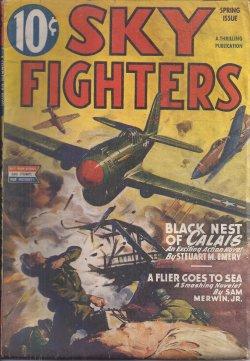
SKY FIGHTERS: Spring 1945
Sky Fighters (Steuart M. Emery; Sam Merwin, Jr.; Joe Archibald; Jackson V. Scholz; Hal White; Robert Sidney Brown; Capt. George H. Fritz)
Verlag: Better Publications, NY, 1945
- Softcover
- Zeitschrift
Anbieter: Books from the Crypt, N. Potomac, MD, USABooks from the Crypt
Verkäufer/-in kontaktierenVerkäufer/-in mit 5 SternenVerbandsmitglied: IOBA
Zustand: Gebraucht - Gut
EUR 27,05
EUR 4,81 VersandVersand innerhalb von USAAnzahl: 1 verfügbar
Wraps. Zustand: Very Good+. Vol. XXXII, no. 1. Pulp magazine. Slim wartime issue, 82pps. Cover is uncredited for "Black Nest of Calais" (novel) by Steuart M. Emery. Includes "A Flier Goes to Sea" (novelet) by Sam Merwin, Jr.; "Ambrose Hooley, C.O." by Joe Archibald; "Fair Dinkum" by Jackson V. Scholz; "The Birds Sing Bass" by Ha…l White; "Burma Blitz" by Robert Sidney Brown. Features: "Tarmac Talk" by 'The Skipper'; "The Tulsa Tornado" by Capt. George H. Fritz"; "Pilot's Quiz"; "Hari Kiri Trail" by Carter Sprague [Sam Merwin, Jr]; "Wings of War". Illustrated by Morey and others. Tanning; minor edge tears and chip. Magazine.

Verlag: The Commandant, Royal Canadian School of Artillery, Canada, 1965
- Softcover
- Erstausgabe
Anbieter: RareNonFiction, IOBA, Ladysmith, BC, KanadaRareNonFiction, IOBA
Verkäufer/-in kontaktierenVerkäufer/-in mit 5 SternenVerbandsmitglied: IOBA
Zustand: Gebraucht - Befriedigend
EUR 90,12
EUR 17,50 VersandVersand von Kanada nach USAAnzahl: 1 verfügbar
Paperback. Zustand: Good. First Edition. Features: Memorium to Colonel EG Brooks, DSO, OBE, CD; 1 RCHA; 2 RCHA; 3 RCHA; 4 RCHA; Exercise Frozen Mukluk; Major General TB Strange; Montreal Brigade at Garrison Artillery; Victoria Garrison Battery, B.C.; and much more. 105 pages. Numerous black and white reproductions of photos. Unm…arked with moderate wear. A sound vintage copy.; 8vo.
 Weitere Bilder
No. 5. Map of Chattanooga and Vicinity
(Civil War) Merrill, William Emery [and Capt. Preston C. F. West]
Verlag: Chattanooga, 1863
- Signiert
Anbieter: James Cummins Bookseller, ABAA, New York, NY, USAJames Cummins Bookseller, ABAA
Verkäufer/-in kontaktierenVerkäufer/-in mit 5 SternenZustand: Gebraucht
EUR 8.565,16
EUR 10,50 VersandVersand innerhalb von USAAnzahl: 1 verfügbar
Printed field map, on four joined sheets of blue paper, with manuscript annotations in red by Captain Preston C. F. West. Signed by West below the cartouche. 25x38-3/4 inches. The urgent need for Union military purposes of detailed maps of the interior of the southern states in rebellion quickly became evident after the events a…t Fort Sumter. While the Army Corps of Engineers had skilled mapmakers who had honed their proficiency in the antebellum explorations in the west, their numbers were too few and their services needed in other military engineering roles. Thus, many of the best mapmakers of the Civil War would be members of the U.S. Coast Survey, tasked with mapping the inland regions of the war in addition to their services along the coasts. Among them was Captain Preston C. F. West (1835-1901) detached to service on the staff of General William F. "Baldy" Smith for the first three years of the war, rising to the rank of Major and taking part in numerous battles, including Antietam, Fredericksburg, Gettysburg and Cold Harbor. West's most significant accomplishments would be his role in the Chattanooga campaign in October and November 1863 as a scout, intelligence officer and cartographer. He would be among those thanked by Major General George H. Thomas in a November 22, 1863 letter to USCS superintendent A. D. Bache: "Permit me to thank you most cordially for your kindness in placing under the direction of Brigadier General W. F. Smith, chief engineer department of the Cumberland, Messrs. P. C. E. West, Clarence Fendall, F. W. Dorr, and J. W. Donn, officers of the Coast Survey service. In the short time they have been on duty at these headquarters, they have rendered most valuable service in reconnoitring, surveying, and mapping the country" (quoted in the Report of the Superintendent of the Coast Survey . 1863). In Brigadier General Smith's January 19, 1864 report on the Battle of Chattanooga submitted to Brigadier General John A. Rawlins, he forwarded maps of the region by West, writing: "These maps are mainly due to the exertions of Captain West, U. S. Coast Survey, of my staff, and to the labors of Captains Dorr and Donn . and who all deserve the thanks of the general for theor labors. By them, the distances were determined before the battle of the use of the artillery and also the heights of the artillery positions occupied by us and the enemy" (quoted in the Official Records). The Chattanooga campaign, taking place between September and November 1863, resulted in a decisive Union victory that effectively ended Confederate control of Tennessee and paved the way for the invasion of the Deep South. The present map, on a scale of two inches to the mile and dated just days before the decisive battle, depicts the region from the Tennessee River bend on the western side of Raccoon Mountain in the west to three miles to the east of Tyner's Station on the Chattanooga Knoxville Railroad line imn the east, to Walden's Ridge in the north and the Georgia boundary in the south - i.e. approx. 228 square mile region centered on the Tennessee River just northeast of Chattanooga. This point comprised the strategic Union position on the heights overlooking the city and the river crossings used by the Union to attack the Confederate position on Missionary Ridge. West has added manuscript annotations in red showing the Union positions and movements. Interestingly, the map's cartouche states that it was compiled from surveys under the direction of Captain W. E. Merrill, although West has crossed out his name and added his own in manuscript, suggesting the true source of the survey. This unrecorded field printed map was likely produced via photozincography (aka "zinco"), a process that allowed a manuscript map to be quickly duplicated via a photographic method that transferred a collodion glass plate negative via contact transfer to produce a negative on zinc that could be inked and printed like a lithograph, though without the need for heavy lithographic stones. It was an ideal method for the printing of maps for military use in the field and was a process first used a decade earlier in Great Britain to reproduce maps for the Ordnance Survey. Not in Stephenson Archival repairs on verso to folds Printed field map, on four joined sheets of blue paper, with manuscript annotations in red by Captain Preston C. F. West. Signed by West below the cartouche. 25x38-3/4 inches. Signed.


