
Gesamtpreis (1 Artikel Artikel):
Versandziel:

fries laurent (82 Ergebnisse)
Direkt zu den wichtigsten Suchergebnissen
Suchfilter
Produktart
- Alle Product Types
- B³cher (40)
- Magazine & Zeitschriften (Keine weiteren Ergebnisse entsprechen dieser Verfeinerung)
- Comics (Keine weiteren Ergebnisse entsprechen dieser Verfeinerung)
- Noten (Keine weiteren Ergebnisse entsprechen dieser Verfeinerung)
- Kunst, Grafik & Poster (29)
- Fotografien (Keine weiteren Ergebnisse entsprechen dieser Verfeinerung)
- Karten (13)
- Manuskripte & Papierantiquitõten (Keine weiteren Ergebnisse entsprechen dieser Verfeinerung)
Zustand Mehr dazu
- Neu (Keine weiteren Ergebnisse entsprechen dieser Verfeinerung)
- Wie Neu, Sehr Gut oder Gut Bis Sehr Gut (2)
- Gut oder Befriedigend (4)
- Ausreichend oder Schlecht (Keine weiteren Ergebnisse entsprechen dieser Verfeinerung)
- Wie beschrieben (76)
Einband
- alle Einbõnde
- Hardcover (Keine weiteren Ergebnisse entsprechen dieser Verfeinerung)
- Softcover (Keine weiteren Ergebnisse entsprechen dieser Verfeinerung)
Weitere Eigenschaften
- Erstausgabe (2)
- Signiert (Keine weiteren Ergebnisse entsprechen dieser Verfeinerung)
- Schutzumschlag (Keine weiteren Ergebnisse entsprechen dieser Verfeinerung)
- Angebotsfoto (69)
- Keine Print-on-Demand Angebote (82)
Sprache (1)
Gratisversand
Land des Verkõufers
Verkõuferbewertung
-
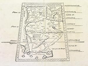
Tabula nona Asiae continentur, Aria, Paropanisadas, Drangiana, Arachosia & Gerdosia.
Verlag: Vienne, 1522
Anbieter: libreria antiquaria perini Sas di Perini, Verona, VR, Italien
Verkõuferbewertung 5 von 5 Sternen

Kunst / Grafik / Poster
Silografia, mm 305x435. Testo latino al verso. Tratta da "Claudii Ptolemaei Alexandrini geographicae enarrationis libri octo". edizione della "Geographia" di Tolomeo curata da Michael Servetus detto Villanovanus, basata su quella del 1522 di Laurent Fries che a sua volta replica la celebre edizione di Waldseemueller del 1513, le cui carte sono qui ridotte. Le carte geografiche del 1522 di Fries, furono ristampate identiche in tutte le edizioni, con per┌ notevoli variazioni al titolo, al testo laterale ad al verso. Originariamente scritta attorno al 150 dopo Cristo, la Geographia di Tolomeo, chiamato "Padre della Geografia", pose i principi fondamentali della geografia scientifica; riscoperta nel periodo rinascimentale ed introdotta in ambito europeo, tradotta in latino dal greco, l'opera rappresent┌ per secoli la pietra miliare della cartografia. Buon esemplare con leggere tracce di sporco superficiale, restauri alla piega centrale ed un lungo strappo verticale restaurato a destra. Nr.cat: P1120007.
-

Aphricae Tabula secunda continet Aphricam & Numidiam.
Verlag: Vienne in Dauphin╦,, 1541
Anbieter: libreria antiquaria perini Sas di Perini, Verona, VR, Italien
Verkõuferbewertung 5 von 5 Sternen
Kunst / Grafik / Poster
Xilografia, mm 280x460. Testo latino al verso. Tratta da "Geographicae enarrationis libri octo", edizione tolemaica curata da Fries basata su quella celebre di Waldseemueller del 1513, le cui carte sono qui ridotte. Buon esemplare con uno strappo restaurato in alto entro la parte incisa, ampi margini. Nr.cat: PB230029.
-
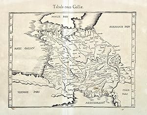
Tabula nova Galliae.
Verlag: Vienne in Dauphin╦,, 1541
Anbieter: libreria antiquaria perini Sas di Perini, Verona, VR, Italien
Verkõuferbewertung 5 von 5 Sternen
Kunst / Grafik / Poster
Xilografia, mm 275x360. Tratta da "Geographicae enarrationis libri octo", edizione tolemaica curata da Fries basata su quella celebre di Waldseemueller del 1513, le cui carte sono qui ridotte. Buon esemplare, ampi margini; foglio lievemente arrossato e con qualche difetto alla piega centrale. Nr.cat: PB240014.
-

Tabula VIII Asiae (reverse)
Verlag: Artist: Ptolemy/ Fries Claudius/ Laurent (Lorenz) ( - 1531 ) Lyon ca : 1535, 1490
Anbieter: Antique Sommer& Sapunaru KG, M³nchen, Deutschland
Verkõuferbewertung 4 von 5 Sternen

Technic: Copper print, colorit: original colored, condition: Some browning, size (in cm): 30,5 x 40,5 cm, Map shows Mongolia (antique name:Scythie ), Tartaria, Tibet and India. Typicly for the time, roughly showing the mountains and cities.
-

Tabula VIII Asiae ( reverse)
Verlag: Artist: Ptolemy/ Fries Claudius/ Laurent (Lorenz) ( - 1531 ) Lyon ca : 1535, 1490
Anbieter: Antique Sommer& Sapunaru KG, M³nchen, Deutschland
Verkõuferbewertung 4 von 5 Sternen
Technic: Copper print, colorit: original colored, condition: Very good, size (in cm): 30,5 x 40,5, Map shows Mongolia (Antique:Scythie ), Tartarien, Tibet and Indien.
-

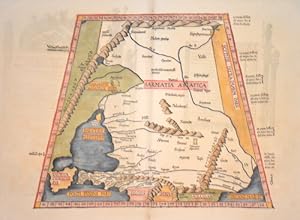
Asiae tabula secunda continet Sarmatiam Asiaticam
Verlag: Vienne, 1522
Anbieter: libreria antiquaria perini Sas di Perini, Verona, VR, Italien
Verkõuferbewertung 5 von 5 Sternen
Kunst / Grafik / Poster
Silografia, mm 305x400. Testo latino al verso. Tratta da "Claudii Ptolemaei Alexandrini geographicae enarrationis libri octo". edizione della "Geographia" di Tolomeo curata da Michael Servetus detto Villanovanus, basata su quella del 1522 di Laurent Fries che a sua volta replica la celebre edizione di Waldseemueller del 1513, le cui carte sono qui ridotte. Le carte geografiche del 1522 di Fries, furono ristampate identiche in tutte le edizioni, con per┌ notevoli variazioni al titolo, al testo laterale ad al verso. Originariamente scritta attorno al 150 dopo Cristo, la Geographia di Tolomeo, chiamato "Padre della Geografia", pose i principi fondamentali della geografia scientifica; riscoperta nel periodo rinascimentale ed introdotta in ambito europeo, tradotta in latino dal greco, l'opera rappresent┌ per secoli la pietra miliare della cartografia. Bell'esemplare, con leggere tracce di sporco superficiale, minimi restauri alla piega centrale ed uno strappo restaurato sulla destra. Nr.cat: P1120008.
-

Europae Tabula secunda continet Hispaniam Baeticam Hispaniam Lusitaniam, & Hispaniam Tarraconensem.
Verlag: Vienne in Dauphin╦, 1541
Anbieter: libreria antiquaria perini Sas di Perini, Verona, VR, Italien
Verkõuferbewertung 5 von 5 Sternen
Kunst / Grafik / Poster
Xilografia, mm 310x450. Testo latino al verso. Tratta da "Geographicae enarrationis libri octo", edizione tolemaica curata da Fries basata su quella celebre di Waldseemueller del 1513, le cui carte sono qui ridotte. Ottimo esemplare con ampi margini, traccia di tarlo alla piega centrale. Nr.cat: PB240010.
-

Europae Tabula tertia continet Galliam Aquitaniam Lugdunensem,Belgicam, & Narbonensem.
Verlag: Vienne in Dauphin╦, 1541
Anbieter: libreria antiquaria perini Sas di Perini, Verona, VR, Italien
Verkõuferbewertung 5 von 5 Sternen
Kunst / Grafik / Poster
Xilografia, mm 370x310. Testo latino al verso. Tratta da "Geographicae enarrationis libri octo", edizione tolemaica curata da Fries basata su quella celebre di Waldseemueller del 1513, le cui carte sono qui ridotte. Ottimo esemplare con ampi margini, foro di tarlo alla piega centrale. Nr.cat: PB240009.
-
Tabula prima Aphricae. Continet Mauritania Tingitanam, Mauritaniam Caesariense.
Verlag: Vienne in Dauphin╦,, 1541
Anbieter: libreria antiquaria perini Sas di Perini, Verona, VR, Italien
Verkõuferbewertung 5 von 5 Sternen
Kunst / Grafik / Poster
Xilografia, mm 260x430. Testo latino al verso. Tratta da "Geographicae enarrationis libri octo", edizione tolemaica curata da Fries basata su quella celebre di Waldseemueller del 1513, le cui carte sono qui ridotte. Ottimo esemplare, ampi margini. Nr.cat: PB230030.
-
Tabula octava Asiae. Continet Scythiam extra Imaum montem & Sericam.
Verlag: Vienne in Dauphin╦,, 1541
Anbieter: libreria antiquaria perini Sas di Perini, Verona, VR, Italien
Verkõuferbewertung 5 von 5 Sternen
Kunst / Grafik / Poster
Xilografia trapezoidale, mm 355x310 c. Testo latino al verso. Tratta da "Geographicae enarrationis libri octo", edizione tolemaica curata da Fries basata su quella celebre di Waldseemueller del 1513, le cui carte sono qui ridotte. Ottimo esemplare, ampi margini. Nr.cat: PB230032.
-

Tabula Septima Asiae. Complectitur Margianam, Bactrianam, Sogdianam, Sacas, & Scythiam, intra Imaum montem.
Verlag: Vienne in Dauphin╦,, 1541
Anbieter: libreria antiquaria perini Sas di Perini, Verona, VR, Italien
Verkõuferbewertung 5 von 5 Sternen
Kunst / Grafik / Poster
Xilografia, mm 280x450. Testo latino al verso. Tratta da "Geographicae enarrationis libri octo", edizione tolemaica curata da Fries basata su quella celebre di Waldseemueller del 1513, le cui carte sono qui ridotte. Ottimo esemplare, ampi margini. Nr.cat: Cod 0718.
-
Tabula Septima Asiae. Complectitur Margianam, Bactrianam, Sogdianam, Sacas, & Scythiam, intra Imaum montem.
Verlag: Vienne in Dauphin╦,, 1541
Anbieter: libreria antiquaria perini Sas di Perini, Verona, VR, Italien
Verkõuferbewertung 5 von 5 Sternen
Kunst / Grafik / Poster
Xilografia, mm 280x450. Testo latino al verso. Tratta da "Geographicae enarrationis libri octo", edizione tolemaica curata da Fries basata su quella celebre di Waldseemueller del 1513, le cui carte sono qui ridotte. Ottimo esemplare, ampi margini. Nr.cat: PB230027.
-

II Tabula Moderna Aphrice
Verlag: Artist: Ptolemy/ Fries Claudius/ Laurent (Lorenz) ( - 1531 ) Lyon ca : 1525, 1490
Anbieter: Antique Sommer& Sapunaru KG, M³nchen, Deutschland
Verkõuferbewertung 4 von 5 Sternen
EUR 1.180,00
EUR 45,00 Versand
Versand von Deutschland nach USAAnzahl: 1 verf³gbar
In den WarenkorbTechnic: Woodcut, colorit: original colored, condition: Perfect condition, size (in cm): 32,5 x 46,5 cm, The trapezoidal map shows Tunisia and Libya in North Africa. Above is a title banner; the country?s mountains and rivers are roughly marked. The reverse side features two initials, a scene depicting North Africans, text and ornamentation. The typical Ptolemaic watermark in the centre, on the right.
-

Tabula IIII Aphricae.
Verlag: Artist: Ptolemy/ Fries Claudius/ Laurent (Lorenz) ( - 1531 ) Lyon ca : 1535, 1490
Anbieter: Antique Sommer& Sapunaru KG, M³nchen, Deutschland
Verkõuferbewertung 4 von 5 Sternen
EUR 1.920,00
EUR 45,00 Versand
Versand von Deutschland nach USAAnzahl: 1 verf³gbar
In den WarenkorbTechnic: Woodcut, colorit: original colored, condition: Perfect condition, size (in cm): 29,5 x 44,5 cm, The trapezoidal map shows North Africa. The country, mountains and rivers are roughly marked, with the various climate zones shown at the edge. The reverse side features two initials, text and ornamentation.
-

Tabu VII Asiae
Verlag: Artist: Ptolemy/ Fries Claudius/ Laurent (Lorenz) ( - 1531 ) Lyon ca : 1525, 1490
Anbieter: Antique Sommer& Sapunaru KG, M³nchen, Deutschland
Verkõuferbewertung 4 von 5 Sternen
EUR 1.130,00
EUR 45,00 Versand
Versand von Deutschland nach USAAnzahl: 1 verf³gbar
In den WarenkorbTechnic: Woodcut, colorit: original colored, condition: Perfect condition, size (in cm): 31 x 45 cm, Map shows as trapezoid projection the Caspian sea with Russia, Turmenistan, Kasachstan, Usbekistan and Hindukusch.
-

Tabula superioris Indiae" & "Tartariae maioris"
Verlag: Artist: Ptolemy/ Fries Claudius/ Laurent (Lorenz) ( - 1531 ) Lyon ca : 1530, 1490
Anbieter: Antique Sommer& Sapunaru KG, M³nchen, Deutschland
Verkõuferbewertung 4 von 5 Sternen
EUR 5.660,00
EUR 45,00 Versand
Versand von Deutschland nach USAAnzahl: 1 verf³gbar
In den WarenkorbTechnic: Woodcut, colorit: black/white, condition: Very good, size (in cm): 29 x 45, Map depicts China and Japan.
-

Tabula nova utriusque Indiae
Verlag: Artist: Ptolemy/ Fries Claudius/ Laurent (Lorenz) ( - 1531 ) Lyon ca : 1541, 1490
Anbieter: Antique Sommer& Sapunaru KG, M³nchen, Deutschland
Verkõuferbewertung 4 von 5 Sternen
EUR 4.200,00
EUR 45,00 Versand
Versand von Deutschland nach USAAnzahl: 1 verf³gbar
In den WarenkorbTechnic: Woodcut, colorit: original colored, condition: Some restoration at centerfold, size (in cm): 32 x 44,5 cm, Map shows India with Ceylan (Sri Lanka), and covers from the Horn of Africa, Saudi Arabia through the Malaysian peninsula, cartographically this map is a great improvement over Medieval maps of the region. In the land of north India, a scene is shown of a goat-man setting fire to a young woman. A watermark in the form of a bunch of grapes on the right-hand margin. Compiled by Claudius Ptolemy with the assistance of Lorenz Fries and Michael Servetus. From the 1541 atlas, 2nd edition, published by Gaspar Trechsel and sold by Hughes de la Porte in Lyon. The 1541 edition is notable in that text is missing from some modern maps due to controversies, particularly in connection with the influence of Calvinism at that time (reverse side without text).
-

Tabula VI Asiae
Verlag: Artist: Ptolemy/ Fries Claudius/ Laurent (Lorenz) ( - 1531 ) Lyon ca : 1530, 1490
Anbieter: Antique Sommer& Sapunaru KG, M³nchen, Deutschland
Verkõuferbewertung 4 von 5 Sternen
EUR 7.310,00
EUR 45,00 Versand
Versand von Deutschland nach USAAnzahl: 1 verf³gbar
In den WarenkorbTechnic: Woodcut, colorit: colored, condition: Very good, size (in cm): 28 x 46, map of the Arabian Peninsula.
-

Tabula tertia Asiae compl. Colchidem, Iberiam, Albaniam, & Armeniam maiorem
Verlag: Vienne, 1522
Anbieter: libreria antiquaria perini Sas di Perini, Verona, VR, Italien
Verkõuferbewertung 5 von 5 Sternen
Silografia, mm 300x420. Testo latino al verso. Tratta da "Claudii Ptolemaei Alexandrini geographicae enarrationis libri octo". edizione della "Geographia" di Tolomeo curata da Michael Servetus detto Villanovanus, basata su quella del 1522 di Laurent Fries che a sua volta replica la celebre edizione di Waldseemueller del 1513, le cui carte sono qui ridotte. Le carte geografiche del 1522 di Fries, furono ristampate identiche in tutte le edizioni, con per┌ notevoli variazioni al titolo, al testo laterale ad al verso. Originariamente scritta attorno al 150 dopo Cristo, la Geographia di Tolomeo, chiamato "Padre della Geografia", pose i principi fondamentali della geografia scientifica; riscoperta nel periodo rinascimentale ed introdotta in ambito europeo, tradotta in latino dal greco, l'opera rappresent┌ per secoli la pietra miliare della cartografia. Bell'esemplare, con leggere tracce di sporco superficiale, strappo restaurato a destra, minimi restauri alla piega centrale. Nr.cat: P1120009.
-
Orbis typus universalis iuxta hydrographorum traditionem Exactissime Depicta. 1522. L.F.
Verlag: Johannes Gruninger,
Anbieter: Daniel Crouch Rare Books Ltd, London, Vereinigtes K÷nigreich
Verbandsmitglied: ABA ILAB PBFA
Verkõuferbewertung 4 von 5 Sternen
Karte
EUR 9.494,38
EUR 23,04 Versand
Versand von Vereinigtes K÷nigreich nach USAAnzahl: 1 verf³gbar
In den WarenkorbAn early crack at the modern world Double-page woodcut map. One of the earliest printed maps in an edition of Ptolemy to include the name "America" (Shirley 48). First published in 1522, this example is an early issue, in which the near horizontal crack, emerging from the righthand margin near the equator, is very short, and before the new title-banner, 'Tabu. Totius Orbis', was added. In this map of the modern world "Europe is very crudely drawn with England and Scotland reverting to separate islands. India, which was well defined on Waldseemuller's great 'Carta Marina' of 1515 to be re-issued by Fries himself in 1525 has become a confusing double peninsula, with the largest southward-extending land mass being east of the Ganges delta. South America is shown in part, with the shape of its western coastline inserted more by intuition than by factual report. Magellan had indeed reached the Pacific via Tierra del Fuego in 1519 but his surviving ship did not reach the ports of Europe until September 1522, several months after publication of Fries' work" (Shirley 48). Issued in the first edition of Ptolemy's geography to be edited by Michael Villanovanus, better known as Servetus (1511-1553), born at Villanueva, in Aragon, Spain. While working as an editor for the publisher Trechsel he wrote the preface and many of the modern descriptions for the versos of the celebrated maps. He also edited a second edition printed at Vienne in the Dauphinķ, in 1541. For his writings against the Holy Trinity and infant baptism Servetus was burnt at the stake in 1553. However there were forty counts of heresy against him, including the offence of having asserted, in the text accompanying map 41 (The Holy Land), that Palestine was not as fertile as it was generally believed. Many copies of the book were burned with him on the orders of John Calvin, although the offending passage was not actually written by Servetus, and had appeared previously in the 1522 and 1525 editions, and was pointedly omitted from the second edition of 1541. The maps of the 1522 edition of Ptolemy's geography were cut in wood by Laurent Fries after the original 1513 maps of Martin Waldseemuller (1470-1520). Fries was originally a physician, "at a succession of places in the Alsace region, with a short spell in Switzerland, before settling in Strasbourg, in about 1519. By this time, he had established a reputation as a writer on medical topics, with several publications already to his credit. Indeed, it was thus that Fries met the Strasbourg printer and publisher Johann Gr³ninger, an associate of the St. Die group of scholars formed by, among others, Walter Lud, Martin Ringmann and Martin Waldseemuller. It would seem that Gruninger was responsible for printing several of the maps prepared by Waldseemuller, and for supervising the cutting of the maps for the 1513 edition of Ptolemy, edited by the group. The mapmaker Laurent Fries had studied medicine at the universities of Pavia, Piacenza, and Montpellier, before establishing himself as a physician in the Alsace region and Switzerland, and eventually settling in Strassburg, in about 1519. There he met the printer and publisher Johann Gr³ninger, who worked with the Saint-Diķ group of scholars, which included Walter Lud, Martin Ringmann, and Martin Waldseem³ller. Gr³ninger printed several maps prepared by Waldseem³ller, and supervised the cutting of the woodblocks for his 1513 edition of Ptolemy's 'Geographia'. Fries's first venture into mapmaking was probably in 1520, when he assisted Petrus Apianus in publishing a reduced version of Martin Waldseem³ller's wall-map of the world, first published in 1507. The engraver of the map was almost certainly Laurent Fries, whose initials appear on either side of the garland at the lower right corner. The map, 'Tipus Orbis Universalis Iuxta Ptolomei Cosmographi Traditionem Et Americ Vespucii Aliorque Lustrationes A Petro Apiano Leysnico Elucubrat. An.o Dni MDXX', was issued in an editi.
-

Asiae Tabula Quinta continentur Assyria, Media, Susiana, Persis, Parthia, Carmania deserta, & Hyrcania.
Verlag: Vienne in Dauphin╦, 1541
Anbieter: libreria antiquaria perini Sas di Perini, Verona, VR, Italien
Verkõuferbewertung 5 von 5 Sternen
Kunst / Grafik / Poster
Xilografia, mm 306x460, dipinta a mano. Testo latino al verso. Tratta da ņGeographicae enarrationis libri octoŅ, edizione tolemaica curata da Fries basata su quella celebre di Waldseemueller del 1513, le cui carte sono qui ridotte. Ottimo esemplare con qualche alone marginale e piccolo foro restaurato alla piega centrale.
-
Tabula Nova Partis (Southern Africa 1522 Strasburg Edition)
Verlag: Johannes Gr³ninger, 1522
Anbieter: Rare Collections, Brighton East, VIC, Australien
Verbandsmitglied: ABA
Verkõuferbewertung 5 von 5 Sternen
A Map and Masterpiece: The 1522 Fries/Gr³ninger Geographia This 1522 Strasbourg edition of the Geographia, edited by Laurent Fries and published by Johannes Gr³ninger, is a significant and fascinating work of early modern cartography. While this edition was a commercial failure due to printing errors (later corrected in the 1525 edition), it is highly valued today for its synthesis of cartographic knowledge and its unique artistic elements. ________________________________________ The Map: 'Tabula Nova Partis Aphri' (Recto) The map on the recto, titled Tabula Nova Partis Aphri, is a reduced yet highly detailed woodcut. It is a critical piece of cartographic history, as it's the earliest acquirable map to provide a modern, accurate depiction of Africa from the Equator to the Cape of Good Hope. This work by Lorenz Fries is a synthesis of two groundbreaking sources: Martin Waldseem³ller's 1513 Tabula Moderna Secunde Porcionis Aphrice and his 1516 Carta Marina, which incorporated new discoveries by Portuguese explorers Vasco da Gama and Bartolomeu Dias. The map is a masterful blend of geography and artistic embellishment. It corrects the ancient Ptolemaic error that had Africa connected to China and the Indian Ocean landlocked. It includes detailed illustrations of three enthroned African kings, an elephant, and serpents. A particularly notable feature is the depiction of the King of Portugal, Manuel I, riding a sea monster in the Mare Prassodum, a powerful symbol of Portugal's dominion over the seas following their successful circumnavigation of the continent. The inclusion of Prester John, a legendary Christian monarch believed to rule a vast kingdom in Africa or Asia, is especially compelling. His presence on the map reflects the European hope of finding a powerful Christian ally against Islamic forces, underscoring the spiritual and political motivations driving the Age of Exploration. ________________________________________ The Verso Woodcut: An Attribution to D³rer The reverse of the map is just as significant, bearing a superb woodcut of an indigenous man and woman that is widely attributed to the celebrated German Renaissance artist Albrecht D³rer. The attribution is based on the print's remarkable stylistic qualities, including D³rer's characteristic mastery of the woodcut medium, with intricate and expressive linework, a keen focus on anatomical detail, and a sophisticated use of light and shadow. While the publisher was Gr³ninger, D³rer had known collaborations within the vibrant Strasbourg publishing community, lending historical plausibility to this attribution. The woodcut's humanistic style and its depiction of newly encountered peoples perfectly captured the spirit of the age of exploration, making it a compelling artistic counterpart to the map on the recto. The Map had some minor professional cleaning and currently framed between two panes of glass.
-

Generale Ptho.
Verlag: Johannes Gruninger,
Anbieter: Daniel Crouch Rare Books Ltd, London, Vereinigtes K÷nigreich
Verbandsmitglied: ABA ILAB PBFA
Verkõuferbewertung 4 von 5 Sternen
Karte
EUR 7.120,78
EUR 23,04 Versand
Versand von Vereinigtes K÷nigreich nach USAAnzahl: 1 verf³gbar
In den WarenkorbThe ptolemaic world map from the first issue of Laurent Fries' 'Geographia' Double-page woodcut map of the world. First issue, distinguished by the lack of decoration in the border, which only contains the names of the winds. A reduced version of the old map of the world first published by Waldseemuller in 1513. In 1522 Fries published a new edition of Ptolemy's 'Geographia', in which nearly all the maps were similarly drawn from Waldseemuller's atlas. Fries was born in Alsace in about 1490, he studied medicine at the universities of Pavia, Piacenza, Montpellier, and then established himself as a physician in the Alsace region and Switzerland, before settling in Strasbourg, in about 1519. By this time, "he had established a reputation as a writer on medical topics, with several publications already to his credit. Indeed, it was thus that Fries met the Strasbourg printer and publisher Johann Gr³ninger, an associate of the St. Die group of scholars formed by, among others, Walter Lud, Martin Ringmann and Martin Waldseemuller. It would seem that Gruninger was responsible for printing several of the maps prepared by Waldseemuller, and for supervising the cutting of the maps for the 1513 edition of Ptolemy, edited by the group. This meeting was to introduce an important digression into Fries' life, and for the next five years, from about 1520 to about 1525, he worked in some capacity as a cartographic editor for or with Gr³ninger, exploiting the corpus of material that Waldseemuller had created" (Ashley Bayntun-Williams, Map Forum online). Shirley 47.
-

no title-World
Verlag: Artist: Ptolemy/ Fries Claudius/ Laurent (Lorenz) ( - 1531 ) Lyon ca : 1535, 1490
Anbieter: Antique Sommer& Sapunaru KG, M³nchen, Deutschland
Verkõuferbewertung 4 von 5 Sternen
EUR 9.460,00
EUR 45,00 Versand
Versand von Deutschland nach USAAnzahl: 1 verf³gbar
In den WarenkorbTechnic: Woodcut, colorit: original colored, condition: Perfect condition, size (in cm): 29,5 x 45,35, Map shows the "old" world, it is based on Martin Waldseemuller?s Ptolemaic map of 1513. It has been reduced in size and been redrawn without text on reverse. Ptolemy edition by Trechsel with watermark. The [1535] Lyon edition by Melchior and Gaspar Treschel was burned by Calvin for alleged heresy and is therefore rare.
-

Tabula Septima Asiae
Verlag: Artist: Ptolemy/ Fries Claudius/ Laurent (Lorenz) ( - 1531 ) Lyon ca : 1541, 1490
Anbieter: Antique Sommer& Sapunaru KG, M³nchen, Deutschland
Verkõuferbewertung 4 von 5 Sternen
EUR 4.030,00
EUR 45,00 Versand
Versand von Deutschland nach USAAnzahl: 1 verf³gbar
In den WarenkorbTechnic: Woodcut, colorit: original colored, condition: Perfect condition, size (in cm): 28 x 46 cm, Trapeziod map shows the Caspian sea, Russia and Turkmenistan, Kasachstan, Usbekistan and Hindukusch. Water mark of a grape. Reverse with title and Latin description.
-
Tabula II Asiae
Verlag: Artist: Ptolemy/ Fries Claudius/ Laurent (Lorenz) ( - 1531 ) Lyon ca : 1535, 1490
Anbieter: Antique Sommer& Sapunaru KG, M³nchen, Deutschland
Verkõuferbewertung 4 von 5 Sternen
Technic: Woodcut, colorit: original colored, condition: Perfect condition, size (in cm): 30,5 x 38 cm, Interesting map shows in Trapeziod shape former Sarmatia, now partly Russia with the Black Sea, the Ukraine and the peninsula Krim with the Asow sea. On reverse a dexcription with ornamental decoration.
-

Tabula III Asiae
Verlag: Artist: Ptolemy/ Fries Claudius/ Laurent (Lorenz) ( - 1531 ) Lyon ca : 1520, 1490
Anbieter: Antique Sommer& Sapunaru KG, M³nchen, Deutschland
Verkõuferbewertung 4 von 5 Sternen
Technic: Woodcut, colorit: original colored, condition: Some browning, size (in cm): 30,3 x 42 cm, Map shows the Caucasus with the Caspian and Black Seas, on the reverse a view of the country and its people with description and ornamental decorations.
-

Tabu.VII. Asiae
Verlag: Artist: Ptolemy/ Fries Claudius/ Laurent (Lorenz) ( - 1531 ) Lyon ca : 1525, 1490
Anbieter: Antique Sommer& Sapunaru KG, M³nchen, Deutschland
Verkõuferbewertung 4 von 5 Sternen
EUR 1.130,00
EUR 45,00 Versand
Versand von Deutschland nach USAAnzahl: 1 verf³gbar
In den WarenkorbTechnic: Woodcut, colorit: original colored, condition: Perfect condition, size (in cm): 31,5 x 46 cm, Trapezoidal map shows the Caspian Sea and its surroundings with Turkmenistan, Kazakhstan, Uzbekistan and Hindu Kush. Lily-shaped watermark on the left side. Reverse with Latin description, a view and ornaments.
-

Europae Tabula nona continent Iaziges Metanastas, Daciam, Mysiam superiorem.
Verlag: Artist: Ptolemy/ Fries Claudius/ Laurent (Lorenz) ( - 1531 ) Lyon ca : 1541, 1490
Anbieter: Antique Sommer& Sapunaru KG, M³nchen, Deutschland
Verkõuferbewertung 4 von 5 Sternen
EUR 1.200,00
EUR 45,00 Versand
Versand von Deutschland nach USAAnzahl: 1 verf³gbar
In den WarenkorbTechnic: Woodcut, colorit: original colored, condition: Perfect condition, size (in cm): 29,5 x 50 cm, Trapezoid map of the territory of eastern Europe with Romania, Hungaria, Dalmatia and the european part of Turkey with the Boporus.On reverse the description of the area. The ptolomy watermark on the right margin. Reverse with Latin text.
-

Tabula VIII Europae
Verlag: Artist: Ptolemy/ Fries Claudius/ Laurent (Lorenz) ( - 1531 ) Lyon ca : 1535, 1490
Anbieter: Antique Sommer& Sapunaru KG, M³nchen, Deutschland
Verkõuferbewertung 4 von 5 Sternen
EUR 1.390,00
EUR 45,00 Versand
Versand von Deutschland nach USAAnzahl: 1 verf³gbar
In den WarenkorbTechnic: Copper print, colorit: original colored, condition: Perfect condition, size (in cm): 29 x 46,5 cm, Map shows the European part of Russia with the Ukraine and the Crimean peninsula in trapezoidal shape. Reverse with Latin description and ornamental decorations.

