Fullarton bartholomew (17 Ergebnisse)
 Weitere Bilder
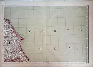
Yorkshire Coast. The Imperial Map of England & Wales.
John Bartholomew, F.R.G.S. A Fullarton & Co. London & Edinburgh.
- Karte
Anbieter: theoldmapman, Clevedon, SOMER, Vereinigtes Königreichtheoldmapman
Verkäufer/-in kontaktierenVerkäufer/-in mit 4 SternenZustand: Gebraucht
EUR 15,51
EUR 7,53 VersandVersand von Vereinigtes Königreich nach USAAnzahl: 1 verfügbar
Single sheet. Original antique map with original hand colouring of the county boundaries as issued. The Imperial Map of England & Wales according to the Ordnance Survey, with the latest additions; shewing clearly every feature of the country, railways and their stations, Roads, Canals, Rivers, Gentlemen's Seats, &c. &c. On the S…cale of 4 Miles to an Inch. 69 x 49.5 cm.
 Weitere Bilder
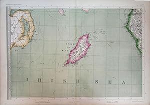
Isle of Man with parts of Northern Ireland & Cumberland. The Imperial Map of England & Wales.
John Bartholomew, F.R.G.S. A Fullarton & Co. London & Edinburgh.
- Karte
Anbieter: theoldmapman, Clevedon, SOMER, Vereinigtes Königreichtheoldmapman
Verkäufer/-in kontaktierenVerkäufer/-in mit 4 SternenZustand: Gebraucht
EUR 23,87
EUR 7,53 VersandVersand von Vereinigtes Königreich nach USAAnzahl: 1 verfügbar
Single sheet. Original antique map with original hand colouring of the county boundaries as issued. The Imperial Map of England & Wales according to the Ordnance Survey, with the latest additions; shewing clearly every feature of the country, railways and their stations, Roads, Canals, Rivers, Gentlemen's Seats, &c. &c. On the S…cale of 4 Miles to an Inch. 69 x 49.5 cm.
 Weitere Bilder
South & West Wales. The Imperial Map of England & Wales.
John Bartholomew, F.R.G.S. A Fullarton & Co. London & Edinburgh.
- Karte
Anbieter: theoldmapman, Clevedon, SOMER, Vereinigtes Königreichtheoldmapman
Verkäufer/-in kontaktierenVerkäufer/-in mit 4 SternenZustand: Gebraucht
EUR 28,64
EUR 7,53 VersandVersand von Vereinigtes Königreich nach USAAnzahl: 1 verfügbar
Single sheet. Original antique map with original hand colouring of the county boundaries as issued. The Imperial Map of England & Wales according to the Ordnance Survey, with the latest additions; shewing clearly every feature of the country, railways and their stations, Roads, Canals, Rivers, Gentlemen's Seats, &c. &c. On the S…cale of 4 Miles to an Inch. 69 x 49.5 cm.
 Weitere Bilder
Devon and the Bristol Channel; parts of Glamorganshire, Somerset and Cornwall. The Imperial Map of England & Wales.
John Bartholomew, F.R.G.S. A Fullarton & Co. London & Edinburgh.
- Karte
Anbieter: theoldmapman, Clevedon, SOMER, Vereinigtes Königreichtheoldmapman
Verkäufer/-in kontaktierenVerkäufer/-in mit 4 SternenZustand: Gebraucht
EUR 28,64
EUR 7,53 VersandVersand von Vereinigtes Königreich nach USAAnzahl: 1 verfügbar
Single sheet. Original antique map with original hand colouring of the county boundaries as issued. The Imperial Map of England & Wales according to the Ordnance Survey, with the latest additions; shewing clearly every feature of the country, railways and their stations, Roads, Canals, Rivers, Gentlemen's Seats, &c. &c. On the S…cale of 4 Miles to an Inch. 69 x 49.5 cm.
 Weitere Bilder
Northumberland with parts of Durham & Cumberland. The Imperial Map of England & Wales.
John Bartholomew, F.R.G.S. A Fullarton & Co. London & Edinburgh.
- Karte
Anbieter: theoldmapman, Clevedon, SOMER, Vereinigtes Königreichtheoldmapman
Verkäufer/-in kontaktierenVerkäufer/-in mit 4 SternenZustand: Gebraucht
EUR 28,64
EUR 7,53 VersandVersand von Vereinigtes Königreich nach USAAnzahl: 1 verfügbar
Single sheet. Original antique map with original hand colouring of the county boundaries as issued. The Imperial Map of England & Wales according to the Ordnance Survey, with the latest additions; shewing clearly every feature of the country, railways and their stations, Roads, Canals, Rivers, Gentlemen's Seats, &c. &c. On the S…cale of 4 Miles to an Inch. 69 x 49.5 cm.
 Weitere Bilder
Lincolnshire & North Norfolk. The Imperial Map of England & Wales.
John Bartholomew, F.R.G.S. A Fullarton & Co. London & Edinburgh.
- Karte
Anbieter: theoldmapman, Clevedon, SOMER, Vereinigtes Königreichtheoldmapman
Verkäufer/-in kontaktierenVerkäufer/-in mit 4 SternenZustand: Gebraucht
EUR 28,64
EUR 7,53 VersandVersand von Vereinigtes Königreich nach USAAnzahl: 1 verfügbar
Single sheet. Original antique map with original hand colouring of the county boundaries as issued. The Imperial Map of England & Wales according to the Ordnance Survey, with the latest additions; shewing clearly every feature of the country, railways and their stations, Roads, Canals, Rivers, Gentlemen's Seats, &c. &c. On the S…cale of 4 Miles to an Inch. 69 x 49.5 cm.
 Weitere Bilder
North Wales. The Imperial Map of England & Wales.
John Bartholomew, F.R.G.S. A Fullarton & Co. London & Edinburgh.
- Karte
Anbieter: theoldmapman, Clevedon, SOMER, Vereinigtes Königreichtheoldmapman
Verkäufer/-in kontaktierenVerkäufer/-in mit 4 SternenZustand: Gebraucht
EUR 28,64
EUR 7,53 VersandVersand von Vereinigtes Königreich nach USAAnzahl: 1 verfügbar
Single sheet. Original antique map with original hand colouring of the county boundaries as issued. The Imperial Map of England & Wales according to the Ordnance Survey, with the latest additions; shewing clearly every feature of the country, railways and their stations, Roads, Canals, Rivers, Gentlemen's Seats, &c. &c. On the S…cale of 4 Miles to an Inch. 69 x 49.5 cm.
 Weitere Bilder
Northern Home Counties of England & East Anglia. The Imperial Map of England & Wales
John Bartholomew, F.R.G.S. A Fullarton & Co. London & Edinburgh.
- Karte
Anbieter: theoldmapman, Clevedon, SOMER, Vereinigtes Königreichtheoldmapman
Verkäufer/-in kontaktierenVerkäufer/-in mit 4 SternenZustand: Gebraucht
EUR 31,03
EUR 7,53 VersandVersand von Vereinigtes Königreich nach USAAnzahl: 1 verfügbar
Single sheet. Original antique map with original hand colouring of the county boundaries as issued. The Imperial Map of England & Wales according to the Ordnance Survey, with the latest additions; shewing clearly every feature of the country, railways and their stations, Roads, Canals, Rivers, Gentlemen's Seats, &c. &c. On the S…cale of 4 Miles to an Inch. Creases down the map near the centrefold have been flattened and strengthened verso. 69 x 49.5 cm.
 Weitere Bilder
Central England. The Imperial Map of England & Wales
John Bartholomew, F.R.G.S. A Fullarton & Co. London & Edinburgh.
- Karte
Anbieter: theoldmapman, Clevedon, SOMER, Vereinigtes Königreichtheoldmapman
Verkäufer/-in kontaktierenVerkäufer/-in mit 4 SternenZustand: Gebraucht
EUR 33,41
EUR 7,53 VersandVersand von Vereinigtes Königreich nach USAAnzahl: 1 verfügbar
Single sheet. Original antique map with original hand colouring of the county boundaries as issued. The Imperial Map of England & Wales according to the Ordnance Survey, with the latest additions; shewing clearly every feature of the country, railways and their stations, Roads, Canals, Rivers, Gentlemen's Seats, &c. &c. On the S…cale of 4 Miles to an Inch. Closed split on lowest 8 cm of the centrefold. 69 x 49.5 cm.
 Weitere Bilder
Westmoreland, most of Yorkshire & North Lancashire, S.E. Westmoreland & S. Durham. The Imperial Map of England & Wales.
John Bartholomew, F.R.G.S. A Fullarton & Co. London & Edinburgh.
- Karte
Anbieter: theoldmapman, Clevedon, SOMER, Vereinigtes Königreichtheoldmapman
Verkäufer/-in kontaktierenVerkäufer/-in mit 4 SternenZustand: Gebraucht
EUR 33,41
EUR 7,53 VersandVersand von Vereinigtes Königreich nach USAAnzahl: 1 verfügbar
Single sheet. Original antique map with original hand colouring of the county boundaries as issued. The Imperial Map of England & Wales according to the Ordnance Survey, with the latest additions; shewing clearly every feature of the country, railways and their stations, Roads, Canals, Rivers, Gentlemen's Seats, &c. &c. On the S…cale of 4 Miles to an Inch. 69 x 49.5 cm.
 Weitere Bilder
Cornwall & S.W. Devon. The Imperial Map of England & Wales.
John Bartholomew, F.R.G.S. A Fullarton & Co. London & Edinburgh.
- Karte
Anbieter: theoldmapman, Clevedon, SOMER, Vereinigtes Königreichtheoldmapman
Verkäufer/-in kontaktierenVerkäufer/-in mit 4 SternenZustand: Gebraucht
EUR 33,41
EUR 7,53 VersandVersand von Vereinigtes Königreich nach USAAnzahl: 1 verfügbar
Single sheet. Original antique map with original hand colouring of the county boundaries as issued. The Imperial Map of England & Wales according to the Ordnance Survey, with the latest additions; shewing clearly every feature of the country, railways and their stations, Roads, Canals, Rivers, Gentlemen's Seats, &c. &c. On the S…cale of 4 Miles to an Inch. 74 x 26 cm.
 Weitere Bilder
North West England & North Midlands as far south as Nottinghamshire & N. Leicestershire. The Imperial Map of England & Wales.
John Bartholomew, F.R.G.S. A Fullarton & Co. London & Edinburgh.
- Karte
Anbieter: theoldmapman, Clevedon, SOMER, Vereinigtes Königreichtheoldmapman
Verkäufer/-in kontaktierenVerkäufer/-in mit 4 SternenZustand: Gebraucht
EUR 33,41
EUR 7,53 VersandVersand von Vereinigtes Königreich nach USAAnzahl: 1 verfügbar
Single sheet. Original antique map with original hand colouring of the county boundaries as issued. The Imperial Map of England & Wales according to the Ordnance Survey, with the latest additions; shewing clearly every feature of the country, railways and their stations, Roads, Canals, Rivers, Gentlemen's Seats, &c. &c. On the S…cale of 4 Miles to an Inch. 69 x 49.5 cm.
 Weitere Bilder
South of England; Somerset, Wiltshire, Berkshire, Hampshire & Dorset, etc. The Imperial Map of England & Wales.
John Bartholomew, F.R.G.S. A Fullarton & Co. London & Edinburgh.
- Karte
Anbieter: theoldmapman, Clevedon, SOMER, Vereinigtes Königreichtheoldmapman
Verkäufer/-in kontaktierenVerkäufer/-in mit 4 SternenZustand: Gebraucht
EUR 40,57
EUR 7,53 VersandVersand von Vereinigtes Königreich nach USAAnzahl: 1 verfügbar
Single sheet. Original antique map with original hand colouring of the county boundaries as issued. The Imperial Map of England & Wales according to the Ordnance Survey, with the latest additions; shewing clearly every feature of the country, railways and their stations, Roads, Canals, Rivers, Gentlemen's Seats, &c. &c. On the S…cale of 4 Miles to an Inch. 69 x 49.5 cm.
 Weitere Bilder
South East England; Kent, Surrey & Sussex. The Imperial Map of England & Wales.
John Bartholomew, F.R.G.S. A Fullarton & Co. London & Edinburgh.
- Karte
Anbieter: theoldmapman, Clevedon, SOMER, Vereinigtes Königreichtheoldmapman
Verkäufer/-in kontaktierenVerkäufer/-in mit 4 SternenZustand: Gebraucht
EUR 40,57
EUR 7,53 VersandVersand von Vereinigtes Königreich nach USAAnzahl: 1 verfügbar
Single sheet. Original antique map with original hand colouring of the county boundaries as issued. The Imperial Map of England & Wales according to the Ordnance Survey, with the latest additions; shewing clearly every feature of the country, railways and their stations, Roads, Canals, Rivers, Gentlemen's Seats, &c. &c. On the S…cale of 4 Miles to an Inch. 69 x 49.5 cm.

Sprache: Deutsch
Verlag: London, A. Fullarton, ca. 1860., 1860
Anbieter: Alte Bücherwelt, Perg, ÖsterreichAlte Bücherwelt
Verkäufer/-in kontaktierenVerkäufer/-in mit 4 SternenZustand: Gebraucht
EUR 42,00
EUR 17,50 VersandVersand von Österreich nach USAAnzahl: 1 verfügbar
41 x 29 cm Sketch Map of the Dutch Possessions in the Indian Archipelago, gest. v. J. Bartholomew, hrsg. A. Fullarton, London, ca. 1860, Orig. Stahlstich, grenzkoloriert, Format 41 x 29 cm, Blattgröße 47,5 x 31 cm, sehr guter Zustand. Sprache: Deutsch Gewicht in Gramm: 550.

Sprache: Deutsch
Verlag: Edingburgh, A. Fullarton, 1880., 1880
Anbieter: Alte Bücherwelt, Perg, ÖsterreichAlte Bücherwelt
Verkäufer/-in kontaktierenVerkäufer/-in mit 4 SternenZustand: Gebraucht
EUR 55,00
EUR 17,50 VersandVersand von Österreich nach USAAnzahl: 1 verfügbar
57 x 47,5 cm Indian Archipelago, compiled form the varios surveys of the british & dutch governments and other materials in possesion of the royal geographical society, bgy J. Bartholomew jun., hrsg. von A. Fullarton, Edinburgh, o.J. (ca. 1880), Origl. Stahlstich, grenzkoloriert, 57 x 47,5 cm (Blatgröße) guter Zustand. Sprache:…Deutsch Gewicht in Gramm: 550.

Sprache: Deutsch
Verlag: ca. 1850., 1850
Anbieter: Alte Bücherwelt, Perg, ÖsterreichAlte Bücherwelt
Verkäufer/-in kontaktierenVerkäufer/-in mit 4 SternenZustand: Gebraucht
EUR 94,00
EUR 17,50 VersandVersand von Österreich nach USAAnzahl: 1 verfügbar
47 x 31 cm West Coast of South America, including Chile & Part of Bolivia & Peru, hrsg. v. A. Fullarton & Co, London o.J. (ca. 1850), Original Stahlstich grenzkoloriert, mit florarer Bordüre, obere Karte zeigt Peru u. Bolivien (v. Swanston); seitlich zwei dekorative kolorierte Figuren (Araucano Indian u. Chilian Miner); untere K…arte zeigt Chile (v. Bartholomew). Format 47 x 31 cm sehr guter Zustand Sprache: Deutsch Gewicht in Gramm: 550.


