
Gesamtpreis (1 Artikel Artikel):
Versandziel:

general staff indian army survey (1 Ergebnisse)
Direkt zu den wichtigsten Suchergebnissen
Produktart
- Alle Produktarten
- B¸cher
- Magazine & Zeitschriften
- Comics
- Noten
- Kunst, Grafik & Poster
- Fotografien
- Karten (1)
-
Manuskripte &
Papierantiquit‰ten
Zustand
- Alle
- Neu
- Antiquarisch/Gebraucht
Einband
- alle Einb‰nde
- Hardcover
- Softcover
Weitere Eigenschaften
- Erstausgabe
- Signiert
- Schutzumschlag
- Angebotsfoto
- Kein Print-on-Demand
Land des Verk‰ufers
Verk‰uferbewertung
-
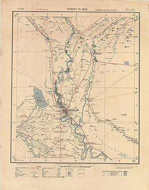
Baghdad Region, Iraq World War I / Mesopotamian Campaign / Calcutta Imprint: Baghdad. Turkey in Asia and Persia. (Rough Provisional Issue, Second Edition) / No. 2C. [Baghdad Regi
Verlag: Calcutta: Survey of India, ., 1915
Anbieter: Antiquariat Dasa Pahor GbR, M¸nchen, Deutschland
Bewertung:

Karte
The seminal map of the Baghdad region used by British Imperial forces during World War I's Mesopotamian Campaign for operational planning during their two attempts to take the Iraqi capital, being the extremely rare 'Degree Sheet' survey of the area predicated upon the best available sources, published in 1915 in Calcutta by the Survey of India on the orders of the General Staff of the Indian Army. Heliozincograph in colour (Very Good, some creasing and minor stains in wide blank margins), 59 x 46 cm (23 x This excellent work is one of the earliest accurate general maps of the Baghdad region. It was made early in 1915 on the orders of the General Staff of the Indian Army and was pushed in Calcutta by the Survey of India, as part of its revolutionary 'Degree Sheet' series of maps of Iraq and Persia. It is predicated upon the very best available information, including Ottoman and German surveys, as well as maps made by Sir William Willcocks, the world famous Anglo-Indian irrigation engineer who in the years before the war was hired by the Sublime Porte to reorder the Euphrates and Tigris water systems to improve agrarian development. Importantly, the present map was principal operational map used by General Townshend and his senior officers during their ill-fated advance upon Baghdad in November 1915. The work is a highly developed topographical map featuring all details necessary to aid military movement. The 'Reference', in the lower left margin, explains the symbols used for: Roads passable for; Telegraph Lines; Telegraph Offices; Mountains (Arabic, Jebel); Mounds (parts of ruined cities, Arabic Tel); Rivers (Shatt); Marshy Lakes (Khor); Dams (Sidd); Muslim Shrines; Open Plains (Desht); Mud Forts (Kasr); Islands (Jezirat); and Date Gardens (usually with Mud Wall enclosures). Additionally, there are innumerable details concerning archaeological sites and abandoned canals, remnants of the numerous great civilizations that once thrived in the Tigris-Euphrates Basin. 'Baghdad', with its ancient 'Mud walls party destroyed' appears on the banks of the Tigris in the lower centre of the view. Innumerable sites are labelled in and around the city, including the 'British Residency', train station, 'Citadel', various city gates (Bab), 'Nasrat Pasha's House', 'Zobeyda's Tomb', and the 'Horse Tramway' to Kadhimain. Notably, the already-completed Iraqi portion of the Baghdad Railway is shown to run northward in the direction of Samarra, 120 miles away, where it t an epic pros that aimed to connect Istanbul with Baghdad. While never finished during the war, its existing lines line permitted Ottoman troops to travel from Istanbul to Baghdad in only 21 days, reducing a journey time which previously took as long as three months. To the south of Baghdad, near a great bend on the Tigris, is the ruins of the ancient city of Ctesiphon, the capital of Sassanian Empire (224 - 641), with the map marking an 'Arched facade, prominent landmark', being the Archway of Chosroes, which is still one of the Middle East's great historical monuments. The site, also called 'Sulman Pak or Sulman Farsi', after Salman the Persian (568 - 653), one of the Prophet Muhammad's key companions, who is thought to be buried there, was the scene of the Battle of Ctesiphon (November 22-25, 1915), whereupon Townshend's army was repelled during the first British attempt on Baghdad. The 'Saltpetre Factory', located across the river form Ctesiphony target that the British would have hoped to c not possible, destroy. The upper right of the map is taken up by the 'D?alalah' (Diyala) River, with the key city of 'Ba'qubah' (Baquba). The major road shown running up from Baghdad through Baquba and beyond was during the times of the Abbasid Caliphate (750 -1517) called the 'Khorasan Road', a key stretch of the Silk Road provided connections to Persia, Central Asia and China. Notably, it was near where the Diyala and the Tigris rivers met that British forces broke the Ottoman lines and proceeded to take Baghdad on March 11, 1917. The Survey of India's 'Degree Sheet' Series: Modernizing the Mapping of Iraq and Persia - It should, at this point, be noted that Britain's interests in the Persian Gulf came under the auspices of the British Raj (the Government of India), although Whitehall retained the right to directly intervene whenever it so chose. For decades, the Indian Navy and Army played key roles in survethe resulting maps being edited and published by the Survey of India. the Survey of India's interests in the Gulf intensified in the early 20th Century, due to oil exploration and the rise of Ottoman-German cooperation which threatened British hegemony. The Survey of India thus sought to develop a series of maps of the Gulf, Iraq and Persia, executed to high scientific standards and uniform scales sufficient to aid both strategic commercial and military use. Colonel Sidney Burrard, who served as the Surveyor General of India from 1908 to 1919, was one of the most driven and visionary modern holders of the office. He decided to expand the highly regarded 'Degree Sheet' surveys of the Indian Subcontinent to include Persia and Iraq (his predecessor had authorized the mapping of Kuwait in this fashion in 1899). As the name suggests, these surveys were comprised of adjoining map sheets that each covered a rectangle of exactly one degree of latitude by one degree of longistance, the present sheet depicts the area between 33∞ and 34∞ N and 44∞ and 45∞ W). While for survey sheets were not novel, they proved highly popular in South Africa during the Second Anglo-Boer War (1899-1902), and the Survey of India started producing degree sheets covering India beginning in 1905. SEE OUR WEB PAGE FOR A LONGER DESCRIPTION. References: N / A No examples of the present edition traced. Cf. [Re: Collections of Iraq Degree sheets from 1921 to 1936 that may include a later edition of the present map:] Oxford University - Bodleian Library: Maps N12487410; University o.