Gesamtpreis (1 Artikel Artikel):
Versandziel:

hondius henricus (122 Ergebnisse)
Direkt zu den wichtigsten Suchergebnissen
Produktart
- Alle Product Types
- Bücher (41)
- Magazine & Zeitschriften
- Comics
- Noten
- Kunst, Grafik & Poster (24)
- Fotografien (1)
- Karten (56)
- Manuskripte & Papierantiquitäten
Zustand
Einband
Weitere Eigenschaften
Gratisversand
- Versand nach USA gratis
Land des Verkäufers
Verkäuferbewertung
-
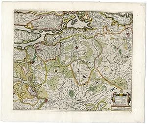
"D. Ioan de Ney Comiss. General Francisc. ." - Jan Neyen (ca.1560-1612) Antwerpen Holland Franciscan friar Habsburg Diplomat Portrait
Verlag: ca. 1630., 1630
Anbieter: Antiquariat Steffen Völkel GmbH, Seubersdorf, Deutschland
Bewertung:

Kunst / Grafik / Poster
Original Kupferstich-Portrait von ca. 1630 - Bild-Maße: ca. 20 x 12 cm - knapp beschnitten und aufmontiert, sonst gut erhalten. | original engraved portrait from from c. 1630 - narrowly cut and mounted on paper, otherwise in very good condition. Sprache: Französisch Gewicht in Gramm: 10.
-
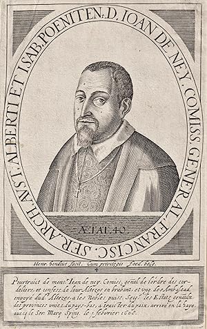
"Lucae Gasselo Helmontano Pictori" - Lucas Gassel (c. 1500-c.1568) Helmond Flemish painter peintre Maler Portrait Wappen coat of arms blason
Verlag: 17. Jh.
Anbieter: Antiquariat Steffen Völkel GmbH, Seubersdorf, Deutschland
Bewertung:
Kunst / Grafik / Poster
Kupferstich-Portrait aus dem 17. Jh. -- Bild-Maße: ca. 20,5 x 12 cm. -- am linken Außenrand mit kleinem hinterlegten Randeinriss, ansonsten gut erhalten. || Original copper engraved portrait from the 17th century. -- with a small deposited marginal tear on the left outer margin, otherwise in good condition. la Gewicht in Gramm: 10.
-
![Bild des Verkäufers für Landkarte von Lothringen, Südlothringen (Lotharingia Meridiona.[lis]), Frankreich. zum Verkauf von Antiquariat Hieronymus](https://pictures.abebooks.com/inventory/md/md31348267749.jpg)
Landkarte von Lothringen, Südlothringen (Lotharingia Meridiona.[lis]), Frankreich.
Verlag: Johannes Janssonius, Amsterdam, 1607
Karte
Zustand: Gut. Gut. Kupferstich, altkoloriert. Blattgröße: 16,7 x 23,6 cm, Druckspiegel: 14,7 x 18,8 cm. . Kräftiger und guter Druck auf leicht gebräuntem Papier, insgesamt gut erhalten. Schöne kleine Landkarte des südlichen Lothringen ("Lotharingia meridiona.[lis]"), zwischen Maas und Vogesen mit dem oberen Lauf der Mosel bis Nancy, aus: "Atlas Minor", Amsterdam 1607. Landkarte, map, carte géographique, carta geografica, France, Frankreich, Francia, Lothringen, Lorraine, Lorena. 400 Gramm.
-
![Bild des Verkäufers für [Portfolio]: Antique Maps of the World in Color zum Verkauf von Between the Covers-Rare Books, Inc. ABAA](https://pictures.abebooks.com/inventory/md/md31614799540.jpg)
[Portfolio]: Antique Maps of the World in Color
Verlag: Sterling Publishing House, Co., Inc, New York, 1960
Anbieter: Between the Covers-Rare Books, Inc. ABAA, Gloucester City, NJ, USA
Verbandsmitglied: ABAA ESA ILAB IOBA
Bewertung:
Erstausgabe
Unbound. Zustand: Very Good. Portfolio. Color facsimiles of 36 historical maps. Each map measures approximately 12" x 9", printed on 17" x 11˝" paper with descriptive text in the left margin. Housed with a title page sheet and unprinted top sheet in a four-fold chemise. Unprinted topsheet sunned at the edges, first two leaves with some very light toning and a couple of tiny corner creases; the maps are otherwise bright and fine. The chemise is good only with toning, wear, and soil, and a 1" creased tear on the cover panel. A nice production, and the chemise has done its job, keeping the maps bright and fresh.
-
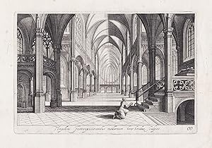
"Templum Introspicientibus modernum" / Inside view of a church with a woman praying
Verlag: Amsterdam ca. 1640., 1640
Anbieter: Antiquariat Steffen Völkel GmbH, Seubersdorf, Deutschland
Bewertung:
Kunst / Grafik / Poster
Original Kupferstich von ca. 1640.-- Blatt-Maße: ca. 29,5 x 39 cm. -- mit alt hinterlegtem Randeinriss, sonst gut erhalten. || Original copper engraving from c. 1640. -- with a deposited marginal tear, otherwise in good condition. la Gewicht in Gramm: 15.
-
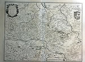
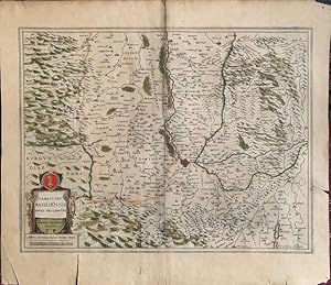
"Comitatus Mansfeldia" - Mansfeld Aschersleben Walkenried Karte map
Erscheinungsdatum: 1630
Anbieter: Antiquariat Steffen Völkel GmbH, Seubersdorf, Deutschland
Bewertung:
Kunst / Grafik / Poster
original Kupferstich-Karte von ca. 1630 - Blatt-Format: ca. 57,5 x 42 cm - mit kleinem Rostfleck, sonst gut erhalten. | original copper engraved map from about 1630 - with small rust stain, otherwise in good condition. | Original! - Kein Nachdruck! - Keine Kopie! | This is an original! - No reprint! - No copy! Sprache: Deutsch Gewicht in Gramm: 1500.
-

Zustand: -. Gefaltete alt-kolorierte Kupferstich-Karte. Blattmaß: 61 x 47 cm. Mit kleinem Riss im unterem Rand. Alterbedingt leicht gebräunt. Fotos gerne auf Anfrage.
-
Northumbria, Cumberlandia, et Dunelmensis Episcopatus
Verlag: Amsterdam, 1607
Anbieter: Clive A. Burden Ltd., Chalfont St. Giles, BUCKS, Vereinigtes Königreich
Bewertung:

Karte
No binding. 360 x 470 mm., dark impression, in good condition. Gerard Mercator's regional map of England including the counties of Northumberland, Durham, Cumberland, and Westmoreland. The preferred first state with the more ornate title cartouche, stippled seas and Mercator's imprint lower centre. Along with French text to the verso and the pagination we can determine this is from the 1609 edition published just two years after the first. As such this example is a nice dark impression. Provenance: Doreen Green 1997. Koeman (1967-70) II ME 12 p. 292 no. 91; Van der Krogt, P. (1997, Atlantes) 5110:1.1.
-
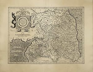
"Principatus Hennenbergensis." - Grafschaft Henneberg Schmalkalden Franken Karte map
Verlag: Amsterdam, Janssonius um 1680., 1680
Anbieter: Antiquariat Steffen Völkel GmbH, Seubersdorf, Deutschland
Bewertung:
Karte
Original altkolorierte Kupferstich-Karte. Gutes Exemplar in seltenem Original-Verlagskolorit. -- Ohne Rückentext. -- Blatt-Maße: ca. 60 x 50,5 cm. -- gut erhalten. || Original old colored engraved map. In very good condition, with the rare original publishing coloring. Without text on verso. -- in good condition.|| Dies ist ein Original! - Kein Nachdruck! - Keine Kopie! -- This is an original! No copy! - No reprint! la Gewicht in Gramm: 1550.
-
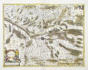
"Territorium Argentoratense." - Strassburg Strasbourg carte Rhein Karte map
Verlag: (Amsterdam, Hondius) um 1680., 1680
Anbieter: Antiquariat Steffen Völkel GmbH, Seubersdorf, Deutschland
Bewertung:
Karte
Original altkolorierte Kupferstich-Karte. Gutes Exemplar in seltenem Original-Verlagskolorit. -- Ohne Rückentext. -- Blatt-Maße: ca. 50 x 62 cm. -- mit mehreren hinterlegten Farbbrüchen (ohne Verlust), sonst gut erhalten. || Original old colored engraved map. In very good condition with the rare original publishing coloring. Without text on verso. -- with several small restorations (without any loss of image), otherwise in good condition. la Gewicht in Gramm: 35.
-
Institut cartogrfic de Catalunya, Barcelona, 2006, edicin facsimil, NĽ47 de la tirada de 200 ejemplares, ilustrado con grficos en color + un mapa a color desplegable, encuadernacin tela editorial con estuche, 21pg., 37*25,5cm., 1350gr.
-
Eboracum, Lincolnia, Derbia, Staffordia, Notinghamia, Lecestria, Rutlandia, et Norfolcia
Verlag: Amsterdam, 1607
Anbieter: Clive A. Burden Ltd., Chalfont St. Giles, BUCKS, Vereinigtes Königreich
Bewertung:
Karte
No binding. 360 x 420 mm., dark impression, in good condition. Gerard Mercator's regional map of England including the counties of Norfolk, Lincolnshire, Yorkshire and inland Rutland, Leicestershire, Nottinghamshire, Derbyshire, and Staffordshire. The preferred first state with the more ornate title cartouche, stippled north sea and Mercator's imprint lower right. Along with French text to the verso and the pagination we can determine this is from the 1609 French edition published just two years after the first. As such this example is a nice dark impression. Provenance: Doreen Green 1997. Deadman & Brooks (2015) p. 320; Koeman (1967-70) II ME 12 p. 292 no. 94; Van der Krogt, P. (1997, Atlantes) 5113:1.1.
-
Cornubia, Devonia, Somersetus, Dorcestria, Wiltonia, Glocestria Monumetha, Clamorga, Caermarden, Penbrok, Cardiga, Radnor, Breknoke, Herefordia et Wigornia
Verlag: Amsterdam, 1607
Anbieter: Clive A. Burden Ltd., Chalfont St. Giles, BUCKS, Vereinigtes Königreich
Bewertung:
Karte
No binding. 370 x 470 mm., dark impression, in good condition. Gerard Mercator's regional map of England including the counties of Cornwall, Devon, Somerset, Dorset, Wiltshire, Gloucestershire, Herefordshire and South Wales. The preferred first state with the more ornate title cartouche, stippled seas and Mercator's imprint lower left. Along with French text to the verso and the pagination we can determine this is from the 1609 edition published just two years after the first. As such this example is a nice dark impression. Provenance: Doreen Green 1997. Koeman (1967-70) II ME 12 p. 292 no. 93; Van der Krogt, P. (1997, Atlantes) 5112:1.1.
-
Gebiet zwischen Aschersleben im Norden, Rinderbruck im Süden sowie Walkenried im Westen und Rockendorff im Osten. Minimal angebräunt. Sprache: Deutsch Gewicht in Gramm: 900.
-
Landkarte von Aragon / Aragonien (Aragonia), Spanien.
Verlag: Johannes Janssonius, Amsterdam, 1648
Karte
Zustand: Gut. Gut. Kupferstich auf Passepartout montiert, altkoloriert. Blattgröße: 18,5 x 22 cm, Druckspiegel: 20,5 x 15,5 cm. . Kräftiger und klarer Druck auf leicht gebräuntem Papier, auf Passepartout montiert, insgesamt gut erhalten. Sehr schöne und seltene Landkarte von Aragon, aus der deutschen Ausgabe: "Atlas Minor. Das ist: Eine kurze jedoch gründliche Beschreibung der ganzen Welt, in zwey Theile abgetheilt", Bd. 1, Amsterdam 1648. Landkarte, map, carte géographique, carta geografica, Spanien, Nordspanien, Spain, Espagnia, Espana, Spagna, Espagne, Arragon. 1200 Gramm.
-
Zustand: Gut. Gut. Kupferstich auf Passepartout montiert, altkoloriert. Blattgröße: 18,5 x 23 cm, Druckspiegel: 20,5 x 16 cm. . Kräftiger und klarer Druck auf leicht gebräuntem Papier, auf Passepartout montiert, insgesamt gut erhalten. Sehr schöne und seltene Landkarte von Navarra, aus der deutschen Ausgabe: "Atlas Minor. Das ist: Eine kurze jedoch gründliche Beschreibung der ganzen Welt, in zwey Theile abgetheilt", Bd. 1, Amsterdam 1648. Landkarte, map, carte géographique, carta geografica, Spanien, Nordspanien, Spain, Espagnia, Espana, Spagna, Espagne, Navarre, Navarra. 1200 Gramm.
-
Tartaria
Verlag: Amsterdam,, 1632
Anbieter: libreria antiquaria perini Sas di Perini, Verona, VR, Italien
Bewertung:
Kunst / Grafik / Poster
Incisione in rame, colorata, 190x260. Decorativa mappa della Russia asiatica, Mongolia, Tartaria fino allo stretto di Bering. Raffigura anche la muraglia cinese. Nr.cat: 100_6911.
-
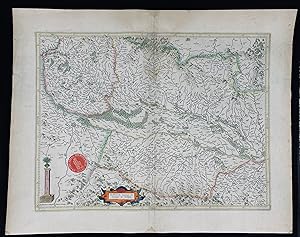
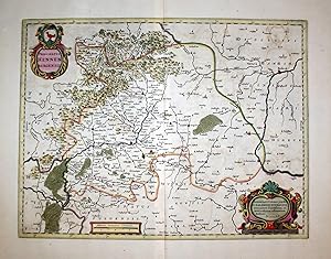
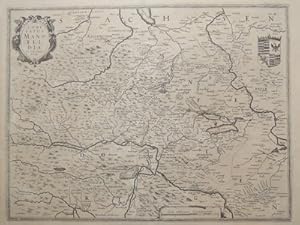
"Moravia".
Verlag: Amsterdam, Hondius, 1627., 1627
Anbieter: Antiquariat MEINDL & SULZMANN OG, Wien - Vienna, Österreich
Bewertung:
Blattgröße ca. 39,5 x 49 cm. Bildausschnitt ca. 33 x 42,5 cm (Mittelfalz geglättet. Papier gebräunt und etw. braunfleckig). Henricus Hondius II., auch Hendrik Hondius der Jüngere (1597- 1651) war der Sohn des berühmten Kartographen Jodocus Hondius, der in Amsterdam ein kartographisches Unternehmen gegründet hatte. Nachdem Hendrik zunächst im elterlichen Betrieb mitgearbeitet hatte, gründete er 1621 in seiner Heimatstadt einen eigenen Verlag. 1633 ging Henricus eine Partnerschaft mit dem Kartographen und seinem Schwager Johannes Janssonius ein, und gemeinsam führten sie das Geschäft weiter.- Rückseite mit lateinischem Text: "Moravia Marchionatus Marhern Germanis . Nomen habet ŕ fluvio Morava.".- Im unteren Teil der Karte (Süden) auch Teile des Weinviertels mit einigen Ortschaften eingezeichnet, wie z.B.: Mailberg, Pulkau, Schrattenthal, Retz, Staatz, Mistelbach, Herrenbaumgarten, Falkenstein, Wildendürnbach, Poysdorf etc.
-
Eboracum, Lincolnia, Derbia, Staffordia, Notinghamia, Lecestria, Rutlandia, et Norfolcia
Verlag: Amsterdam, 1620
Anbieter: Clive A. Burden Ltd., Chalfont St. Giles, BUCKS, Vereinigtes Königreich
Bewertung:
Karte
No binding. 360 x 420 mm., modern wash colour, in good condition. Gerard Mercator's regional map of the east of England taking in the east coast including Norfolk, Lincolnshire, Yorkshire and inland Rutland, Leicestershire, Nottinghamshire, Derbyshire, and Staffordshire. The preferred first state with the more ornate title cartouche, stippled north sea and Mercator's imprint lower right. With German text to the verso. Deadman & Brooks 'Leicestershire' p. 320; Koeman II ME 12 p. 292 no. 94; Van der Krogt, P. (Atlantes) 5113:1.2.
-
Landkarte des Elsass (Breisgau, Sundgau, Schwarzwald), Frankreich.
Verlag: Selbstverlag, Amsterdam, 1623
Karte
Zustand: Gut. Gut. Kupferstich, altkoloriert. Blattgröße: 45 x 57 cm, Druckspiegel: 36,3 x 47,8 cm. . Kräftiger und klarer Druck auf etwas, im Falz und am Rand stärker gebräuntem Papier, kleine Randläsuren, insgesamt gut erhalten. Schöne große Landkarte des Elsass mit dem Breisgau, Sundgau ("Alsatia superior cum Suntgoia et Brisgoia"), Schwarzwald bis Basel, Schweiz - nach Westen hin orientiert, aus: "Atlas sive Cosmographicae Meditationes de Fabrica Mundi et Fabricati Figura", Amsterdam 1623 Landkarte, map, carte géographique, carta geografica, France, Frankreich, Francia, Alsace, Alsazia, Alsace, Black Forrest, Foresta Negra, Foret-Noire. 1800 Gramm.
-
"Nova Alemaniae sive Sveviae Superioris Tabula." - Schwaben Bodensee Karte map
Verlag: Amsterdam, (Hondius?) um 1650., 1650
Anbieter: Antiquariat Steffen Völkel GmbH, Seubersdorf, Deutschland
Bewertung:
Karte
Original altkolorierte Kupferstich-Karte. Gutes Exemplar in seltenem Original-Verlagskolorit. -- Ohne Rückentext. -- Blatt-Maße: ca. 60 x 50,5 cm. -- gut erhalten. || Original old colored engraved map. In very good condition with the rare original publishing coloring. Without text on verso. -- in good condition.|| Dies ist ein Original! - Kein Nachdruck! - Keine Kopie! -- This is an original! No copy! - No reprint! la Gewicht in Gramm: 1550.
-
Zustand: mäßiger Zustand. Niederrhein. Rheinlauf von Rheinberg bis Gorinchem. Hondius. Descriptio Fluminum Rheni, Vahalis et Mosae a Rheno Berca ad Goricomium usque, comprehendens Imperium Noviomagense, Bataviam, Tielae et Bomelij insulas, regionesque conterminas.1642. Kupferstich, alt koloriert. Landkarte, von Henricus Hondius. 37,5 x 49,2 cm (Darstellung), 46 x 57 cm (Blatt).Aus: Johannes Janssonius, Newer Atlas. Das ist Weltbeschreibung Und Volkommene Abbildung Aller unterschiedlichen Koenigreiche, Länder und Provintzen Sampt Ost- und West-Indien, davon gnugsam und volkommener bericht zufinden (Amsterdam: Hondius / Janssonius 1642). Zeigt den Lauf des Rheins von Rheinberg (nördlich von Duisburg) bis Gorinchem, Rhenen und Culenborg (südlich von Utrecht). Bugfalte mittig angeschmutzt. Rand unten rechts hinterlegt. Insgesamt leicht gebräunt und angeschmutzt. Verso niederländischer Text. Mäßig guter Zustand.Henricus Hondius (1597 Amsterdam - 1651 Amsterdam). Niederländischer Kupferstecher, Kartograf und Verleger, Sohn des Jodocus Hondius. Zunächst Mitarbeit im väterlichen Betrieb. 1621 Gründung eines eigenen Verlags. Sein Vater kaufte 1604 die Platten von Mercators Weltatlas und veröffentlichete 1606 den Mercator-Hondius-Atlas mit etwa 40 neuen Karten. 1641 gab Henricus Hondius eine neue Auflage des Mercator-Hondius-Atlas mit veränderten Hondius-Karten heraus. Obere Teilkarte links unten mit Titelkartusche. Mittig Kartusche mit 2 Maßstäben / Meilenzeiger und Windrose sowie Verlegeradresse AMSTELODAMI / Excusum apud Henricum Hondium habitans supra damum sub insigno Atlantis. Untere Teilkarte mittig mit 2 Maßstäben / Meilenzeigern und rechts oben Windrose.
-
Kein Einband. Zustand: Gut. Es handelt sich hierbei um eine originale, altkolorierte Kupferstich-Landkarte des Elsass und des Breisgaus von Henricus Hondius (1597 - 1651) aus dem Jahr 1630. *** Titel: Alsatia superior cu Suntgoia & Brisgoia *** Gebiet bzw. Ort: Elsaß, Breisgau, Sundgau *** Kartograph: Henricus Hondius (1597 - 1651) *** Jahr: 1630 *** Größe des Plattenbereichs: 36 x 47 cm *** Technik: Kupferstich *** Zustand (Perfekt/ Sehr gut/ Gut/ Ordentlich/ Mäßig/ Schlecht): In gutem Erhaltungszustand *** Bemerkungen: Die altkolorierte Karte zeigt das Breisgau, Sundgau und den Schwarzwald mit dem Rhein zwischen Basel und Straßburg - - - International buyers welcome. If you have any questions, please don't hesitate to ask. - - - ----- Auf Wunsch stellen wir Ihnen gerne ein kostenfreies Echtheitszertifikat aus ------ If you wish, we will gladly provide a certificate of authenticity free of charge ---.
-
![Bild des Verkäufers für Austria Archiducatus auctore Wolfgango Lazio [Archdiocese of Austria] zum Verkauf von Antiqua Print Gallery](https://pictures.abebooks.com/inventory/md/md31683071131.jpg)
Zustand: Good. Austria Archiducatus auctore Wolfgango Lazio by Henricus Hondius c1636 old map. Original 17th century antique atlas map with old hand colouring; Henricus Hondius (c1636). 37.5 x 54.5cm, 14.75 x 21.5 inches. Condition: Good. The map has been laid down onto board. Please contact us if you would like to arrange to view this map. The map has been laid down onto board.
-

Fossa Eugeniana quae a Rheno ad Mosam duci coepta est
Verlag: Schenk, Peter & Valck, Gerard, Amsterdam, 1710
Karte
Kein Einband. Zustand: Gut bis sehr gut. Fossa Eugeniana. "Fossa Eugeniana quae a Rheno ad Mosam duci coepta est". Altkol. Kupferstich Karte von H. Hondius, dat. 1627. Bei P. Schenk & G. Valck, um 1710. Mit 3 ornament. Kart. 36,5:48,5 cm. Niederrhein-Karte in der Begrenzung Xanten-Wesel-Kempen-Venlo mit dem nie fertiggestellten Kanal im Zentrum.
-
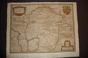
Nassovia comitatus.
Verlag: Amsterdam, ca. 1630., 1630
Large in-folio. Nice original copper -engraving . Old colouring. Good copy of this map of the Nassau region. 3 cartouches.
-
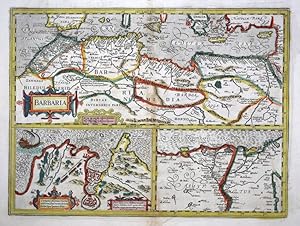
Barbaria.
Verlag: Amsterdam, Henricus Hondius, 1636, English text edition. 355 x 470mm (14 x 18˝ inches)., 1636
Anbieter: Tooley, Adams & Co., Wallingford, OXON, Vereinigtes Königreich
Bewertung:
Original colour; minor defects mostly confined to the lower part of centrefold and slight soiling to the margins, otherwise a very good example. A fine map of the Barbary coast (Northern Africa), from Morocco to the Nile Delta. Two smaller maps occupy the lower part of the sheet, Tunes and the Nile Delta in more detail. Translated into English by Henry Hexham - Quatermaster to the Regiment of Colonel Goring. UNCOMMON. KOEMAN: Me 41A.
-
Territory Basiliensis Nova Descriptio
Verlag: [Amsterdam: Jansson, c.1640]., 1640
Anbieter: William Matthews/The Haunted Bookshop, Sidney, BC, Kanada
Bewertung:

Copper-engraved map on laid paper, hand-coloured cartouches in lower left corner. Hand-colouring to entire map. Text on the verso in French, heading titled: Le Territoire de BASLE. Hand-coloured initial on verso. Signature mark on verso is IIi. Plate size is 49cm x 38cm, on a sheet measuring 55cm x 48.5cm. Old yellowed tape repair on verso at fold and edges, some splitting at fold, pin holes to margins, tears in lower margin, very good condition. Probably from the French edition of Jansson's "Nouveau Theatre du Monde ou Nouvel Atlas" [c.1640]. Numbered in pencil at upper right with the numeral "67". From WorldCat's description: "The first French editions of the Atlas Novus appeared in three volumes in 1639, a year after the inaugural Latin version. The promptness with which the translation was readied meant that these were largely identical to the Latin original in material and structure, although several revisions were made to the order of contents to better tailor Jansson's offering to the Francophone market: thus, the French part of the Atlas was given new precedence over the Dutch one, and the Spanish and Portuguese chapters were detached from the French section in order to give the latter a stronger thematic coherence than it had previously had. Despite these similarities, the publication of the French editions was quite different from the Latin. After issuing the latter together, by 1639 Jansson and Hondius had resolved to print their own copies of the French title under their own imprints, and this division of resources and duplication of editions has resulted in a distinct, more complex publishing history. Indeed, variations in the stock of plates available to the former partners resulted in two quite separate classes of Atlas, with as many as twenty-five different maps between them, Jansson's typically the more up to date. Matters are further complicated by both Jansson and Hondius' habit of regularly updating their imprints for several years from 1639 onwards, resulting in confusing arrays of dates across the volumes of a single set.".
-
Belgian Flanders
Verlag: Henricus Hondius, Amsterdam, 1630
Karte
Kein Einband. Zustand: Sehr gut. Belgian Flanders. "Habes hic Novam & accuratissimam descriptionem tractus illius Flandriae per que superioribus .". Orig. copperplate engraving, H. Hondius in Amsterdam, 1630. Engraved by P. Kaerius. With ornamental title-cartouche. 37:51,5 cm (14 1/2 x 20 1/4 inch.). Koeman I, map 3205:1, ed. 1:107 (1630 Latin). - A m ap of the eastern part of Belgian (West) Flanders with the cities of Ghent, Bruges, Ostend and others. - Nice, darkt impression. P rinted on paper sized 47,5:56,5 cm.
-
Antique Map-BRABANTIAE-BRABANT-BREDA-BIESBOSCH-Hondius-c.1640
Verlag: c.1640, 1640
Anbieter: Pictura Prints, Art & Books, Overasselt, Niederlande
Bewertung:
'BRABANTIAE PARS SEPTENTRIONALIS CONTINENS MARCHIONATUS S.ROM. IMPERIJ. BERGOZOMARUM. COMITATUS ()'This print shows a map called Brabantić pars septentrionalis, the west of province of Brabant in the Netherlands. At the bottom right is a title cartouche with scale bar and compass rose. The city of Breda (Baronie Breda) is in the center of the map. In the north Hoekse Waard-Dordrecht-Bommelerwaard, Biesbosch. In the east 's-Hertogenbosch-Oirschot and the Brabantse Kempen. In the south Antwerp-Herentals and in the west Heenvliet-Tholen-Hulst. On the reverse Dutch text about the marquisate of Bergen op Zoom.Made by after an anonymous artist.Medium: Engraving / original handcoloured on hand laid (verge) paper.Sheet size: 66.2 x 55.6 cm (26.06 x 21.89 inch). Image size: 55 x 46.5 cm. (21.65 x 18.31 inch).MAP-BRABANTIAE-BRABANT-BREDA-DEN BOSCH-BIESBOSCH-NETHERLANDS-BERGEN OP ZOOM-ANTWERP | RB-T.29-LARGEBACKGROUND INFORMATIONThis attractive print was first published in 1633. This one is probably a later edition.Biography engraver: Henricus Hondius also: Hendrik or Henri (Amsterdam, 1597 16 August 1651) is one of the most important Dutch cartographers. Condition: good, given age. Fold as published. Two small tears in fold restored. Map backed: thin Japanese paper glued to the reverse. Folds and creases in margins. General age-related toning and/or occasional minor defects from handling. Please study scan carefully.