
Gesamtpreis (1 Artikel Artikel):
Versandziel:

lisle guillaume (258 Ergebnisse)
Direkt zu den wichtigsten Suchergebnissen
Produktart
- Alle Product Types
- Bücher (124)
- Magazine & Zeitschriften
- Comics
- Noten
- Kunst, Grafik & Poster (26)
- Fotografien
- Karten (108)
- Manuskripte & Papierantiquitäten
Zustand
Einband
Weitere Eigenschaften
- Erstausgabe (18)
- Signiert (1)
- Schutzumschlag (2)
- Angebotsfoto (190)
- Keine Print-on-Demand Angebote (252)
Gratisversand
- Versand nach USA gratis
Land des Verkäufers
Verkäuferbewertung
-
Softcover. Zustand: Bon. Petite(s) trace(s) de pliure sur la couverture. Ammareal reverse jusqu'ŕ 15% du prix net de ce livre ŕ des organisations caritatives. ENGLISH DESCRIPTION Book Condition: Used, Good. Slightly creased cover. Ammareal gives back up to 15% of this book's net price to charity organizations.
-

Bulletin de la Société d'Etudes Camerounaises - Territoires du Cameroun - n° 5 de mars 1944 , (L'origine du nom Fulani - La numération de 1 ŕ 10 dans les dialectes Habé de Garoua, Guider, Poli et Rey-Bouba - Proverbes Badjue et Bikélé - Note sur la faune coléoptérologique du Cameroun (Coléoptčres) - Observations sur l'exploitation des Funtumias - Dans la flore du Cameroun, l'Alstonia Congensis - Questionnaire sur l'agriculture indigčne - L'Institut français d'Afrique Noire de Dakar et la Société d'Etudes Camerounaises)
Verlag: Institut Français d'Afrique Noire ŕ Douala , Bulletin de la Société d'Etudes Camerounaises, 1944
Anbieter: Librairie Philoscience, Malicorne sur Sarthe, Frankreich
Bewertung:

1 carte en frontispice (situation des dialectes dans ce volume) 2eme édition, 1944 Book condition, Etat : Bon broché, sous couverture imprimée éditeur grise grand In-8 1 vol. - 96 pages Contents, Chapitres : M.D.W. Jeffreys : L'origine du nom Fulani - H. Baudelaire : La numération de 1 ŕ 10 dans les dialectes Habé de Garoua, Guider, Poli et Rey-Bouba - Dr. H. Koch : Proverbes Badjue et Bikélé - M. de Lisle : Note sur la faune coléoptérologique du Cameroun (Coléoptčres) - M. Guillaume : Observations sur l'exploitation des Funtumias - R.P. Jos. Sohler : Dans la flore du Cameroun, l'Alstonia Congensis - Questionnaire sur l'agriculture indigčne - L'Institut français d'Afrique Noire de Dakar et la Société d'Etudes Camerounaises legeres traces de pliures sur la couverture qui reste en bon état, intérieur frais et propre, papier ŕ peine jauni, cela reste un bon exemplaire - Bulletin de la Société d'Etudes Camerounaises - Territoires du Cameroun - n° 5 de mars 1944 180.
-
![Bild des Verkäufers für Encomium Febris Quartanae 1542 [LeatherBound] zum Verkauf von True World of Books](https://pictures.abebooks.com/inventory/md/md31616443019.jpg)
LeatherBound. Zustand: New. LeatherBound edition. Condition: New. Reprinted from edition. Leather Binding on Spine and Corners with Golden leaf printing on spine. Bound in genuine leather with Satin ribbon page markers and Spine with raised gilt bands. A perfect gift for your loved ones. NO changes have been made to the original text. This is NOT a retyped or an ocr'd reprint. Illustrations, Index, if any, are included in black and white. Each page is checked manually before printing. As this print on demand book is reprinted from a very old book, there could be some missing or flawed pages, but we always try to make the book as complete as possible. Fold-outs, if any, are not part of the book. If the original book was published in multiple volumes then this reprint is of only one volume, not the whole set. Sewing binding for longer life, where the book block is actually sewn (smythe sewn/section sewn) with thread before binding which results in a more durable type of binding. Pages: 95.
-
![Bild des Verkäufers für Tables geographiques (1760) [LeatherBound] zum Verkauf von True World of Books](https://pictures.abebooks.com/inventory/md/md31657452908.jpg)
LeatherBound. Zustand: New. LeatherBound edition. Condition: New. Reprinted from 1760 edition. Leather Binding on Spine and Corners with Golden leaf printing on spine. Bound in genuine leather with Satin ribbon page markers and Spine with raised gilt bands. A perfect gift for your loved ones. NO changes have been made to the original text. This is NOT a retyped or an ocr'd reprint. Illustrations, Index, if any, are included in black and white. Each page is checked manually before printing. As this print on demand book is reprinted from a very old book, there could be some missing or flawed pages, but we always try to make the book as complete as possible. Fold-outs, if any, are not part of the book. If the original book was published in multiple volumes then this reprint is of only one volume, not the whole set. Sewing binding for longer life, where the book block is actually sewn (smythe sewn/section sewn) with thread before binding which results in a more durable type of binding. Pages: 108.
-
![Bild des Verkäufers für Sylva observationum linguae latinae 1537 [LeatherBound] zum Verkauf von True World of Books](https://pictures.abebooks.com/inventory/md/md31616440929.jpg)
Sylva observationum linguae latinae 1537 [LeatherBound]
Erscheinungsdatum: 2023
Buch Print-on-Demand
LeatherBound. Zustand: New. LeatherBound edition. Condition: New. Reprinted from edition. Leather Binding on Spine and Corners with Golden leaf printing on spine. Bound in genuine leather with Satin ribbon page markers and Spine with raised gilt bands. A perfect gift for your loved ones. NO changes have been made to the original text. This is NOT a retyped or an ocr'd reprint. Illustrations, Index, if any, are included in black and white. Each page is checked manually before printing. As this print on demand book is reprinted from a very old book, there could be some missing or flawed pages, but we always try to make the book as complete as possible. Fold-outs, if any, are not part of the book. If the original book was published in multiple volumes then this reprint is of only one volume, not the whole set. Sewing binding for longer life, where the book block is actually sewn (smythe sewn/section sewn) with thread before binding which results in a more durable type of binding. Pages: 175.
-
![Bild des Verkäufers für Oratio suasoria ad Carolum Caes. Imp. Aug. et Franciscum Galliarum regem, de pace & concordia inter ipsos constituenda (1537) [LeatherBound] zum Verkauf von True World of Books](https://pictures.abebooks.com/inventory/md/md31618878009.jpg)
LeatherBound. Zustand: NEW. LeatherBound edition. Condition: New. Reprinted from 1537 edition. Leather Binding on Spine and Corners with Golden leaf printing on spine. Bound in genuine leather with Satin ribbon page markers and Spine with raised gilt bands. A perfect gift for your loved ones. NO changes have been made to the original text. This is NOT a retyped or an ocr'd reprint. Illustrations, Index, if any, are included in black and white. Each page is checked manually before printing. As this print on demand book is reprinted from a very old book, there could be some missing or flawed pages, but we always try to make the book as complete as possible. Fold-outs, if any, are not part of the book. If the original book was published in multiple volumes then this reprint is of only one volume, not the whole set. Sewing binding for longer life, where the book block is actually sewn (smythe sewn/section sewn) with thread before binding which results in a more durable type of binding. Pages: 54.
-
![Bild des Verkäufers für Deliberatio, an et quatenus expediat controversias super religione christiana motus, decidi absolvique in synodo universali (1546) [LeatherBound] zum Verkauf von True World of Books](https://pictures.abebooks.com/inventory/md/md31619014385.jpg)
LeatherBound. Zustand: NEW. LeatherBound edition. Condition: New. Reprinted from 1546 edition. Leather Binding on Spine and Corners with Golden leaf printing on spine. Bound in genuine leather with Satin ribbon page markers and Spine with raised gilt bands. A perfect gift for your loved ones. NO changes have been made to the original text. This is NOT a retyped or an ocr'd reprint. Illustrations, Index, if any, are included in black and white. Each page is checked manually before printing. As this print on demand book is reprinted from a very old book, there could be some missing or flawed pages, but we always try to make the book as complete as possible. Fold-outs, if any, are not part of the book. If the original book was published in multiple volumes then this reprint is of only one volume, not the whole set. Sewing binding for longer life, where the book block is actually sewn (smythe sewn/section sewn) with thread before binding which results in a more durable type of binding. Pages: 76.
-
![Bild des Verkäufers für uvres du feu p. Andre: contenant und traite de l'homme selon les . [LeatherBound] zum Verkauf von True World of Books](https://pictures.abebooks.com/inventory/md/md31534097185.jpg)
uvres du feu p. Andre: contenant und traite de l'homme selon les . [LeatherBound]
Erscheinungsdatum: 2023
Buch Print-on-Demand
LeatherBound. Zustand: New. LeatherBound edition. Condition: New. Reprinted from 1766 edition. Leather Binding on Spine and Corners with Golden leaf printing on spine. Bound in genuine leather with Satin ribbon page markers and Spine with raised gilt bands. A perfect gift for your loved ones. NO changes have been made to the original text. This is NOT a retyped or an ocr'd reprint. Illustrations, Index, if any, are included in black and white. Each page is checked manually before printing. As this print on demand book is reprinted from a very old book, there could be some missing or flawed pages, but we always try to make the book as complete as possible. Fold-outs, if any, are not part of the book. If the original book was published in multiple volumes then this reprint is of only one volume, not the whole set. Sewing binding for longer life, where the book block is actually sewn (smythe sewn/section sewn) with thread before binding which results in a more durable type of binding. Pages: 385.
-

No Binding. Zustand: Near Fine. 1st Edition thus. DH202357. Map size: 17cm x 13.5cm. Original copper engraving originally published in 'Introduction a l'Histoire Generale et Politique de l'Univers.' Shows regions and towns. De L'Isle is considered one of the greatest French cartographers. Original fold lines. Uncoloured as issued. A near fine, tight, clean copy with good margins.
-
Pas de couverture. Zustand: Trčs bon. Format 390 x 440 carte trčs fraîche marque de pli.
-
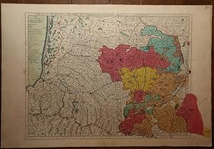
Carte du Béarn de La Bigorre de l'Armagnac et des Pays Voisins. Kupferstichkarte mit Flächenkolorit.
Verlag: A Paris, De L'Isle, 1712
Karte
Zustand: Gut. 48 x 63 cm (Blattgröße: 54,5 x 81 cm). *Frühe Delisle-Karte, zeigt einen Teil des französischen Westens. Die Provinzen mit Flächenkolorit, davon eine im Westen von Hand im Kolorit über den Plattenrand hinaus konturiert und koloriert. - Guillaume Delisle (1675-1726) war ein französischer Kartograph aus Paris. Delisle war der erste, der eine wissenschaftlich vergleichende Geographie anbahnte, indem er bei seinen Werken auch Reiseberichte und die Werke von Naturforschern benutzte. Er gab zahlreiche Landkarten heraus, die sich durch Eleganz und Schärfe von den früheren Karten unterschieden. - Gut erhalten. / Early print of this Delisle map. Good condition. Sprache: Deutsch Gewicht in Gramm: 1000.
-
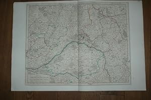
Carte de la Beau ce du Gatinois de la Sologne et Pays voisin dans la Generalité d'Orleans. Kupferstichkarte mit Grenzkolorit.
Verlag: A Paris, De L'Isle, 1716
Karte
Zustand: Gut. 49,5 x 62 cm (Blattgröße: 54,5 x 81 cm). *Frühe Delisle-Karte, zeigt das Gebiet um die Loire, im Zentrum die Stadt Orleans. - Guillaume Delisle (1675-1726) war ein französischer Kartograph aus Paris. Delisle war der erste, der eine wissenschaftlich vergleichende Geographie anbahnte, indem er bei seinen Werken auch Reiseberichte und die Werke von Naturforschern benutzte. Er gab zahlreiche Landkarten heraus, die sich durch Eleganz und Schärfe von den früheren Karten unterschieden. - Der breite weiße Rand wurde zeitgenössisch eigens aufmontiert, vermutlich wegen der enormen Blattgröße. Sauber und gut erhalten. / Early print of this Delisle map. The large white edges were mounted separate in contemporarily time (probably because of the large sheet size). Very good condition. Sprache: Deutsch Gewicht in Gramm: 1000.
-

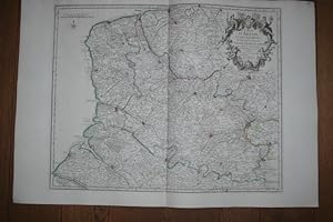
Carte de la Prevosté et Vicomté de Paris Dressée sur un grand nombre de Memoires particuliers. Kupferstichkarte.
Verlag: A Paris, De L'Isle, 1711
Karte
Zustand: Gut. 49,5 x 64 cm (Blattgröße: 54,5 x 81 cm). *Frühe Delisle-Karte, zeigt das Gebiet um Paris. Unkoloriert (nur die Stadt Paris ist rot markiert). - Guillaume Delisle (1675-1726) war ein französischer Kartograph aus Paris. Delisle war der erste, der eine wissenschaftlich vergleichende Geographie anbahnte, indem er bei seinen Werken auch Reiseberichte und die Werke von Naturforschern benutzte. Er gab zahlreiche Landkarten heraus, die sich durch Eleganz und Schärfe von den früheren Karten unterschieden. - Der breite weiße Rand wurde zeitgenössisch eigens aufmontiert. Sauber und sehr gut erhalten. / Early print of this Delisle map. The large white edges were mounted separate in contemporarily time. Good condition. Sprache: Deutsch Gewicht in Gramm: 1000.
-
Zustand: Gut. 48 x 60 cm (Blattgröße: 54,5 x 81 cm). *Frühe Delisle-Karte, zeigt den Nordosten von Frankreich südlich Calais mit dem östlich angrenzenden Gebiet von Belgien. - Guillaume Delisle (1675-1726) war ein französischer Kartograph aus Paris. Delisle war der erste, der eine wissenschaftlich vergleichende Geographie anbahnte, indem er bei seinen Werken auch Reiseberichte und die Werke von Naturforschern benutzte. Er gab zahlreiche Landkarten heraus, die sich durch Eleganz und Schärfe von den früheren Karten unterschieden. - Der breite weiße Rand wurde zeitgenössisch eigens aufmontiert, vermutlich wegen der enormen Blattgröße. Sauber und gut erhalten. / Early print of this Delisle map. The large white edges were mounted separate in contemporarily time (probably because of the large sheet size). Very good condition. Sprache: Deutsch Gewicht in Gramm: 1000.
-
Carte Particuličre d'Anjou et de Touraine ou de la Partie Meridionale de la Generalite de Tours. Teilkolorierte Kupferstichkarte.
Verlag: A Paris, De L'Isle, 1720
Karte
Zustand: Gut. 48,5 x 66 cm (Blattgröße: 54,5 x 81 cm). *Frühe Delisle-Karte, zeigt detailliert das Flussgebiet des Anjou südlich Tours in der Bretagne. - Guillaume Delisle (1675-1726) war ein französischer Kartograph aus Paris. Delisle war der erste, der eine wissenschaftlich vergleichende Geographie anbahnte, indem er bei seinen Werken auch Reiseberichte und die Werke von Naturforschern benutzte. Er gab zahlreiche Landkarten heraus, die sich durch Eleganz und Schärfe von den früheren Karten unterschieden. - Der breite weiße Rand wurde zeitgenössisch eigens aufmontiert. Sauber und sehr gut erhalten. / Early print of this Delisle map. The large white edges were mounted separate in contemporarily time. Good condition. Sprache: Deutsch Gewicht in Gramm: 1000.
-
Untertitel: ovvero Metodo facile per apprendere in breve la Geografia con un esatto Trattato della Sfera che fa vedere il moto degli Astri, i varj Sistemi del Mondo, e el uso deii Glovi ec. Untergebiet: Alte Drucke Abbildungen: Incisione alla pagina dell Titutlo. Manchano le 24 Carte Zustand: Buona condizione Seiten: 328 S. Format: 8°. Einband: Pbd. d. Zt. Gebiet: Atlanten.
-
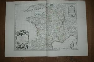
La France. Dressée sur un grand nombre de Cartes particulieres manuscrites ou imprimée levées sur les lieux. Teilkolorierte Kupferstichkarte.
Verlag: A Paris, De L'Isle, 1703
Karte
Zustand: Gut. 49 x 67 cm (Blattgröße: 54,5 x 81 cm). *Frühe Delisle-Karte, zeigt detailliert das gesamte Frankreich. Große Titelkartusche unten links. - Guillaume Delisle (1675-1726) war ein französischer Kartograph aus Paris. Delisle war der erste, der eine wissenschaftlich vergleichende Geographie anbahnte, indem er bei seinen Werken auch Reiseberichte und die Werke von Naturforschern benutzte. Er gab zahlreiche Landkarten heraus, die sich durch Eleganz und Schärfe von den früheren Karten unterschieden. - Der breite weiße Rand wurde zeitgenössisch eigens aufmontiert. Linker Außenrand mit kleinem Tintenfleckchen, insgesamt sauber und gut erhalten. / Early print of this Delisle map. The large white edges were mounted separate in contemporarily time. Good condition. Sprache: Deutsch Gewicht in Gramm: 1000.
-
Carte du Bourdelois, du Perigord et des Provinces voisines. Teilkolorierte Kupferstichkarte mit Grenz- und Flächenkolorit.
Verlag: A Paris, De L'Isle, 1714
Karte
Zustand: Gut. 71 x 64 cm (Blattgröße: 76 x 80,5 cm). *Frühe Delisle-Karte, eine zweite (größere) Variante unter diesem Titel (und in gleichem Maßstab). Sie ist größer als die andere Karte (nochmals aufgeklappt) und enthält den gesamten Südwesten Frankreichs. Die Karte zeigt das Gebiet des Bordeaux Weines und Perigord mit den Flußgebiet der Garonne und reicht südlich bis zur Spanischen Grenze. Es sind die Städte Bordeaux (im nördl. Teil) sowie Bayonne und Toulouse im südlichen Teil bis an die Pyrenäen enthalten. - Guillaume Delisle (1675-1726) war ein französischer Kartograph aus Paris. Delisle war der erste, der eine wissenschaftlich vergleichende Geographie anbahnte, indem er bei seinen Werken auch Reiseberichte und die Werke von Naturforschern benutzte. Er gab zahlreiche Landkarten heraus, die sich durch Eleganz und Schärfe von den früheren Karten unterschieden. - Der breite weiße Rand wurde zeitgenössisch eigens aufmontiert. Im Mittelfalz unten mit Einriß im weißen Rand. Seitliche Ränder mit Altersbräunung. Insgesamt gut erhalten. / Early print of this Delisle map. The large white edges were mounted separate in contemporarily time. A small tear in outline margin, altogether in good condition. Sprache: Deutsch Gewicht in Gramm: 1000.
-
Pas de couverture. Zustand: Trčs bon. Circolo di Baviera e di Austria. Gravure sur cuivre. Coloris main. Edité en 1740 ŕ Venise par de L'Isle. Dimension du feuillet : 362 x 430 mm. Dimension au coup de planche : 299 x 354 mm.Le prix du port est calculé selon la destination et le poids du colis. Cartes.
-
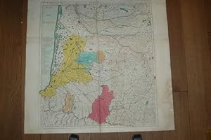
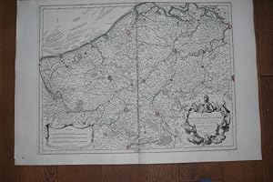
Carte du Brabant dressee sur plusieurs Cartes particulieres Manuscrites ou Imprimees levees sur les lieux Rectifiees par quelques Observations et autres Memoires Par Guillaume de L'isle
Verlag: Jean Covens et Corneille Mortier, 1750
Anbieter: Morning Mist Books and Maps, Cirencester, Vereinigtes Königreich
Bewertung:
Karte
No Binding. Zustand: Fair. Sectionalised and mounted on linen. Some folds split along the linen. Old lateral crease due to incorrect folding. Linen worn and discoloured. Map with full colouring but with heavy toning and some marking. Undated, usually considered to be C.1750 but there is very faint writing within the cartouche, where the dates 1671,1699 and 1726 are just visible. Many towns/cities shown with fortifications. Area covered is most of Belgium with part of Holland (Namur on the southern border; Anvers to the west; Batenburg to the north; Venlo to the east). An interesting map but not in the best condition. Sheet size when open flat; 64.5cm by 66cm approx. More details available on request. (201non366).
-
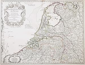
"Carte des Provinces Unies des Pays Bas" - Holland Nederland Netherlands Niederlande Holland Nederland Netherlands Niederlande Pays Bas
Verlag: Paris, Buache, 1762
Anbieter: Antiquariat Steffen Völkel GmbH, Seubersdorf, Deutschland
Bewertung:
Karte
Blatt-Masse ca. 52 x 70 cm. -- Altkolorierte Kupferstich-Karte. Original old colored etched map. - Zeigt das Gebiet von den Niederlanden und Teilen von Belgien. -- am oberen Außenrand teils etwas fleckig - sonst gut erhalten. || Dies ist ein Original! - Kein Nachdruck! - Keine Kopie! -- This is an original! - No copy! - No reprint! Sprache: Französisch Gewicht in Gramm: 30.
-
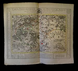
Carte topographique du diocčse de Senlis.
A Amsterdam, chez J. Covens et C. Mortier, s.d. [1745]. Dimensions : 668 x 563 mm. Importante carte gravée avec rehauts aquarellés figurant - outre un plan particulier de la ville de Senlis et de Crespy [sic], des villages tels : Le Plessis Belleville, Dammartin, Lusarche, Creil ou encore Crépy en Valois. ''La carte est entourée d'une table alphabétique des lieux du Diocčse de Senlis et, sous la carte, d'un "avertissement" et d'une "explication des marques" en français et en néerlandais''. Pliure centrale. Infime tout autant que discrčte auréole en marge droite. Du reste, trčs belle condition.
-
Carte du Comte de Flandre. Dressée sur differens morceaux levez sur les lieux fixéz par les Observations Astronomiques. Altkolorierte Kupferstichkarte.
Verlag: A Paris, chez l'Auteur sur de Quai de l'Horloge, 1704
Karte
Zustand: Gut. 48,5 x 65 cm (Blattgröße ca. 54,5 x 80 cm). *Frühe Delisle-Karte, zeigt Belgien. - Guillaume Delisle (1675-1726) war ein französischer Kartograph aus Paris. Delisle war der erste, der eine wissenschaftlich vergleichende Geographie anbahnte, indem er bei seinen Werken auch Reiseberichte und die Werke von Naturforschern benutzte. Er gab zahlreiche Landkarten heraus, die sich durch Eleganz und Schärfe von den früheren Karten unterschieden. - Der breite weiße Rand wurde zeitgenössisch eigens aufmontiert, vermutlich wegen der enormen Blattgröße. Sauber und gut erhalten. / Early print of this Delisle map. The large white edges were mounted separate in contemporarily time (probably because of the enormous sheet size). Very good condition. Sprache: Deutsch Gewicht in Gramm: 1000.
-
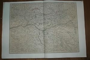
Partie Septentrionale De La Souabe. Par Guillaume De l'Isle Geographe de L'Academie Royale des Sciences. Altkolorierte Kupferstichkarte.
Verlag: A Paris, chez l'Auteur sur de Quai de l'Horloge et a Amsterdam, chez Louis Renard, 1704
Karte
Zustand: Gut. 47,5 x 63,5 cm (Blattgröße: 55 x 81 cm). *Frühe Delisle-Karte, zeigt das nordwestliche Württemberg und Mittelfranken von Stuttgart bis Nürnberg in der West-Ost-Erstreckung und von Winsheim bis Göppingen in der Nord-Süd-Erstreckung. - Guillaume Delisle (1675-1726) war ein französischer Kartograph aus Paris. Delisle war der erste, der eine wissenschaftlich vergleichende Geographie anbahnte, indem er bei seinen Werken auch Reiseberichte und die Werke von Naturforschern benutzte. Er gab zahlreiche Landkarten heraus, die sich durch Eleganz und Schärfe von den früheren Karten unterschieden. - Der breite weiße Rand wurde zeitgenössisch eigens aufmontiert, vermutlich wegen der enormen Blattgröße. Sauber und gut erhalten. / Early print of this Delisle map. The large white edges were mounted separate in contemporarily time (probably because of the enormous sheet size). Very good condition. Sprache: Deutsch Gewicht in Gramm: 1000.
-
Carte de la Terre Sainte ou des Douze Tribus d'Israel.
Verlag: Chez l'Auteur, Rue des Noyers,, Paris,, 1797
Anbieter: Llibreria Antiquŕria Delstres, Canet de Mar, BCN, Spanien
Bewertung:
Mapa grabado a doble hoja, folio imperial. Iluminado a mano. Ligeras manchas de humedad y pequeńos puntos de óxido; reforzado en el reverso con papel cartulina. Faltas de papel que afectan ligeramente al mapa. 52x70,5 cm. (Papel). 49,5x65 cm. (Mapa).
-

No Binding. Zustand: Near Fine. DH202014. Printed in c.1750 and published in Paris. Size: 40cm x 35cm. Original copper engraving. Contemporary hand-colouring. Original minor fold lines. In near fine, clean condition with small margins, as issued. PRICE INCLUDES POSTAGE IN THE UK. FOR WORLDWIDE SHIPPING, PLEASE CONTACT US FOR A QUOTE.
-
![Bild des Verkäufers für Nuova Carta dell' Isole Britanniche divise nei tre Regni d'Inghilterra, di Scozia, e d'Irlanda by [L'Isle (Guillaume de)] zum Verkauf von Robinson Street Books, IOBA](https://pictures.abebooks.com/inventory/md/md30671333070.jpg)
Nuova Carta dell' Isole Britanniche divise nei tre Regni d'Inghilterra, di Scozia, e d'Irlanda by [L'Isle (Guillaume de)]
Verlag: Albrizzi, 1743, Venice, 1743
Zustand: Very Good. Prompt shipment, with tracking. we ship in CLEAN SECURE BOXES NEW BOXES Full margins, uncolored, slight tearing to edges, folded with some repair to two folds. Very good. *.
-
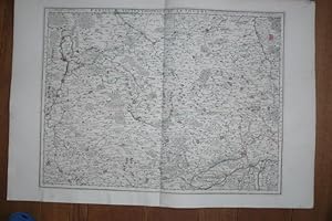
Nova territorii Parisiensis tabula ad usum Serenissimi Burgundiae Ducis.
Verlag: Amsterdam 1696, (P. Mortier)
Zustand: -. Kupferstich. 53 x 65 cm. Mittig alt zusammengesetzt. Altkoloriert. Wenige kleine Einrisse am Rand. Sonst gut erahlten.
-
Graeciae Antiquae - Antique Greece
Verlag: le Quai de l'horloge sub signo Aquilae Aurea, 1707
Anbieter: Apple Boutique, Drawings, Prints & Books, Geneva, Schweiz
Bewertung:
Karte
No Binding. Zustand: Fair. Graeciae Antiquae tabula nova in qu a locorum situs tum ad distantias itinerarias tum ad observationes astronomicas exactus litorum fleocurae et alia id genus ad accuratas recentiorum rationes accomodatar sunt. Auctore Guillelmo Delisle, ex Regia Scientiarum Academia. Graeciae pars Meridionalis. Parisiis, apud Autorem in Ripa vulgo le Quai de l'horloge sub signo Aquilae Aurea, cum Privilegio advicennium, oct. 1707. Author: Lisle, Guillaume de, 1675-1726 Date: 1707 Condition : Fair, some damages to the margins, small tear, a vertical center fold as issued,
-
Carte de l'Afrique Françoise ou du Senegal [Map of French West Africa, or Senegal]
Erscheinungsdatum: 1727
Karte
Zustand: Very Good. 'L'Afrique Françoise ou du Senegal'. French West Africa. DE L'ISLE 1727 map. Large antique 18th century atlas map, printed on thick, good quality paper with original outline hand colour/color and decorative title & scale cartouches; Guillaume de l'Isle (1727 (This date is printed on the map)). 52.0 x 65.0cm, 20.5 x 25.5 inches; this is a folding map. Condition: Very Good. Please contact us if you would like to arrange to view this map. There is nothing printed on the reverse side, which is plain. This large eighteenth century map shows the coast of West Africa and its hinterland between Ras Nouadhibou (marked with its French name of Cap Blanc) which is today on the border between Mauritania and Western Sahara, and Conakry, the capital of present day Guinea, to the south of Cape Verga. It includes the coastline of the present day countries of Mauritania, Senegal, The Gambia, Guinea-Bissau and part of Guinea. The courses of the Senegal and Gambia rivers are charted, although in common with many cartographers of the time, de l'Isle confuses the Niger and Senegal rivers; the Senegal river is named as "Riviere du Senegal ou Niger". Timbuktu and the Niger river itself (named on the map as the "Guien Riviere") are marked on the extreme right hand side of the map. Further to the south, the fictitious "Lac de Sapert" is shown as the source of the Gambia River. The Cap-Vert (the site of the city of Dakar) is shown; Île de Gorée is marked, as is the Fort & Île St-Louis further to the north. The map is indicated to have been published posthumously by de l'Isle's widow.


![Bild des Verkäufers für Carte de l'Afrique Françoise ou du Senegal [Map of French West Africa, or Senegal] zum Verkauf von Antiqua Print Gallery](https://pictures.abebooks.com/inventory/md/md31102179035.jpg)