Gesamtpreis (1 Artikel Artikel):
Versandziel:

mission créqui montfort sénéchal grange (4 Ergebnisse)
Direkt zu den wichtigsten Suchergebnissen
Produktart
- Alle Produktarten
- Bücher (3)
- Magazine & Zeitschriften
- Comics
- Noten
- Kunst, Grafik & Poster
- Fotografien
- Karten (1)
-
Manuskripte &
Papierantiquitäten
Zustand
Einband
- alle Einbände
- Hardcover
- Softcover
Weitere Eigenschaften
- Erstausgabe (2)
- Signiert
- Schutzumschlag
- Angebotsfoto
- Kein Print-on-Demand (2)
Gratisversand
Land des Verkäufers
Verkäuferbewertung
-
![Bild des Verkäufers für Rapport sur une mission scientifique en Amerique du Sud (Bolivie, Republique Argentine, Chili, Perou) par M. de Crequi Montfort et Senechal de la Grange. (1904) [Leatherbound] zum Verkauf von S N Books World](https://pictures.abebooks.com/inventory/md/md31376429667.jpg)
LeatherBound. Zustand: New. Leatherbound edition. Condition: New. Leather Binding on Spine and Corners with Golden leaf printing on spine. Bound in genuine leather with Satin ribbon page markers and Spine with raised gilt bands. A perfect gift for your loved ones. Reprinted from 1904 edition. NO changes have been made to the original text. This is NOT a retyped or an ocr'd reprint. Illustrations, Index, if any, are included in black and white. Each page is checked manually before printing. As this print on demand book is reprinted from a very old book, there could be some missing or flawed pages, but we always try to make the book as complete as possible. Fold-outs, if any, are not part of the book. If the original book was published in multiple volumes then this reprint is of only one volume, not the whole set. IF YOU WISH TO ORDER PARTICULAR VOLUME OR ALL THE VOLUMES YOU CAN CONTACT US. Resized as per current standards. Sewing binding for longer life, where the book block is actually sewn (smythe sewn/section sewn) with thread before binding which results in a more durable type of binding. Pages: 78 Language: French Pages: 78.
-
![Bild des Verkäufers für Rapport sur une mission scientifique en Amerique du Sud (Bolivie, Republique . [LeatherBound] zum Verkauf von True World of Books](https://pictures.abebooks.com/inventory/md/md31533708193.jpg)
Rapport sur une mission scientifique en Amerique du Sud (Bolivie, Republique . [LeatherBound]
Erscheinungsdatum: 2023
Buch Print-on-Demand
LeatherBound. Zustand: New. LeatherBound edition. Condition: New. Reprinted from 1904 edition. Leather Binding on Spine and Corners with Golden leaf printing on spine. Bound in genuine leather with Satin ribbon page markers and Spine with raised gilt bands. A perfect gift for your loved ones. NO changes have been made to the original text. This is NOT a retyped or an ocr'd reprint. Illustrations, Index, if any, are included in black and white. Each page is checked manually before printing. As this print on demand book is reprinted from a very old book, there could be some missing or flawed pages, but we always try to make the book as complete as possible. Fold-outs, if any, are not part of the book. If the original book was published in multiple volumes then this reprint is of only one volume, not the whole set. Sewing binding for longer life, where the book block is actually sewn (smythe sewn/section sewn) with thread before binding which results in a more durable type of binding. Pages: 80 Language: French.
-
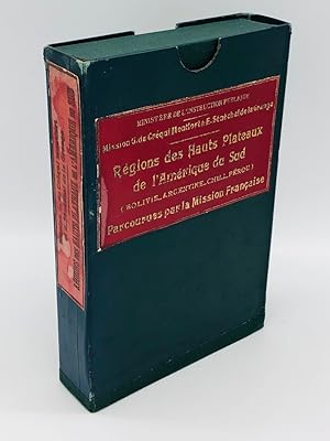
Couverture rigide. Zustand: Trčs bon. Edition originale. Rare large scale map of the South American Highlands of Bolivia, Argentina, Chile and Peru, compiled by Victor Huot as part of a comprehensive study of the region by the Scientific Mission of G. de Créqui-Montfort and E. Sénéchal de la Grange. The map was drawn from a series of scientific expeditions in South America, mainly in to the Andes, made at the beginning of this century, on various subjects, including cartography, orography, physical anthropology, linguistics, fauna, paleontology, etc. South American Highlands Regions (Bolivia, Argentina, Chile, Peru) Traveled by the French Mission - Map Prepared by V. Huot from the Works of the Members of the Mission, the The following quote appeared in the Journal de la Societe des Americanistes de Paris (Nouvelle Series, Volume II, 1903, at page 346). A French scientific map of South America. - So far, the cartography of the Bolivian region of the Andes is quite poor. For Colombia, Ecuador, Peru, Argentina, Chile, the general maps are still incomplete, even embryonic, but on the whole, quite satisfactory. For the Bolivian territory, no serious cartographic work exists to our knowledge. The maps of Ondarza, Reck, Muchin, Moreno, Idiaquez, Pando are more or less official publications, but all their documentation is based on information communicated by the local administrators. And, unless we are mistaken, very few of the cartographers knew first-hand the terrain represented. The recently published map of the Créqui Montfort-E. Sénéchal de la Grange Mission fills a signifiicant gap, it is more than simply and improvement, it is a foundational map, it will be a solid starting point and will serve as a basis for all future studies. Thanks to this map, for the first time, we can grasp, in outline, the topographic anatomy of these high Bolivian plateaus which constitute a region so original and so distinct. The map of the French Mission, besides the high plateau of Bolivia, that is to say all the Republic of Bolivia (minus the plains of Beni and Chaco), also offers us the Peruvian departments of Arequipa, Puno and Moquegua, the Chilean provinces of Tacna, Tarapaca and Antofagasta. It includes, in addition, the territory of Argentina, the province of Jujuy, part of that of Salta and the Argentine national territory of the Andes. In short, it shows all the high plateau of South America from 15 ° to 26 ° lat. S., in a developed format (1m 70> <1m 30). The Bolivian provinces of Lipez, Chichas, and Porco, left almost blank by the old maps, appear here in all the reality of their relief, delineated with the greatest care. For the departments of Arequipa and Moquegua, for the provinces of Jujuy and Salta, the French map also introduces important new detail . This is a beautiful work that honors its creators and authors, well served, the rest, for the translation of their observations and statements, by the talent of the draftsman, Mr. Victor Huot. It is a masterful preface to the great publications of archeology and ethnography promised by the Count de Créqui Montfort and eagerly awaited by all the Americanists. Ministry of Public Instruction. Mission G. de Créqui Montfort-E. Seneschal of the Barn, 1903. Regions of the high plateaus of South America (Bolivia, Argentina, Chile, Peru), visited by the French Mission. Map drawn up by V. Huot, based on the work of the members of the Mission, the original unpublished sources and the most recent documents, on a scale of 1: 750,000. Paris, Ehrard Brothers, 1905. We note 3 examples in North American institutional collections, 1 example in the National Library of Chile and several examples in French libraries.
-
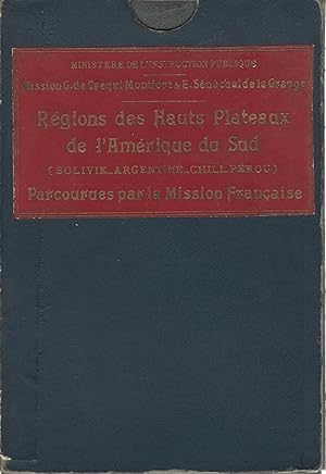
Régions des Hauts Plateaux de L'Amérique du Sud: (Bolivie, Argentine, Chili, Pérou) parcourues par la Mission Française
Verlag: Erhard freres, Paris, 1905
Karte Erstausgabe
Couverture rigide. Zustand: Trčs bon. Edition originale. 6 cartes de 62 x 69 cm formant une grande carte de 186 x 138 cm. Etablie en 1903, imprimée en 1905. Carte dressée par V. Huot d'aprčs les Travaux des Membres de la Mission, les Sources originales inédites, et les Documents les plus récents ŕ l'échelle de 1/750'000. 6 cartes en couleurs montées sur lin, sous portefeuille et dans emboitage avec titre doré. Rare. 6 maps of 62 x 69 cm forming a large map of 186 x 138 cm. Map drawn by V. Huot according to the Works of the Members of the Mission, the original unpublished Sources, and the most recent Documents at the scale of 1/750'000. 6 colored maps mounted on linen, in wallet and in slipcase with gilt title. Rare.