
Gesamtpreis (1 Artikel Artikel):
Versandziel:

mono county (7 Ergebnisse)
Direkt zu den wichtigsten Suchergebnissen
Suchfilter
Produktart
- Alle Product Types
- B³cher (6)
- Magazine & Zeitschriften (Keine weiteren Ergebnisse entsprechen dieser Verfeinerung)
- Comics (Keine weiteren Ergebnisse entsprechen dieser Verfeinerung)
- Noten (Keine weiteren Ergebnisse entsprechen dieser Verfeinerung)
- Kunst, Grafik & Poster (Keine weiteren Ergebnisse entsprechen dieser Verfeinerung)
- Fotografien (Keine weiteren Ergebnisse entsprechen dieser Verfeinerung)
- Karten (Keine weiteren Ergebnisse entsprechen dieser Verfeinerung)
- Manuskripte & Papierantiquitõten (1)
Zustand Mehr dazu
- Neu (Keine weiteren Ergebnisse entsprechen dieser Verfeinerung)
- Wie Neu, Sehr Gut oder Gut Bis Sehr Gut (1)
- Gut oder Befriedigend (Keine weiteren Ergebnisse entsprechen dieser Verfeinerung)
- Ausreichend oder Schlecht (Keine weiteren Ergebnisse entsprechen dieser Verfeinerung)
- Wie beschrieben (6)
Einband
- alle Einbõnde
- Hardcover (Keine weiteren Ergebnisse entsprechen dieser Verfeinerung)
- Softcover (3)
Weitere Eigenschaften
- Erstausgabe (3)
- Signiert (Keine weiteren Ergebnisse entsprechen dieser Verfeinerung)
- Schutzumschlag (Keine weiteren Ergebnisse entsprechen dieser Verfeinerung)
- Angebotsfoto (7)
- Keine Print-on-Demand Angebote (7)
Sprache (1)
Preis
- Beliebiger Preis
- Weniger als EUR 20 (Keine weiteren Ergebnisse entsprechen dieser Verfeinerung)
- EUR 20 bis EUR 45 (Keine weiteren Ergebnisse entsprechen dieser Verfeinerung)
- Mehr als EUR 45
Gratisversand
- Kostenloser Versand nach USA (Keine weiteren Ergebnisse entsprechen dieser Verfeinerung)
Land des Verkõufers
Verkõuferbewertung
-
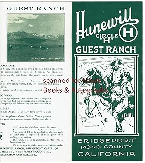
Hunewill Circle "H" Guest Ranch
Verlag: Bridgeport, Mono County, California
Anbieter: Houle Rare Books/Autographs/ABAA/PADA, Palm Springs, CA, USA
Verkõuferbewertung 5 von 5 Sternen

Manuskript / Papierantiquitõt
No Binding. Zustand: Fine. ca. 1937. 11 3/4" x 9". Brochure opens to form 6 panels. Printed in green on cream paper. Illustrated with 10 b/w halftone photographs by Frasher. Open May 15 to November 1st. 1 week minimum stay. Founded in 1862, the ranch comprised of 5,000 acres at an elevation of 6,500 feet. Fine (minor signs of handling). The ranch was located at an elevation of 6500 feet in Bridgeport Valley. Owners were S.H. and Lenore M. Hunewill and Millie H. Morris.
-

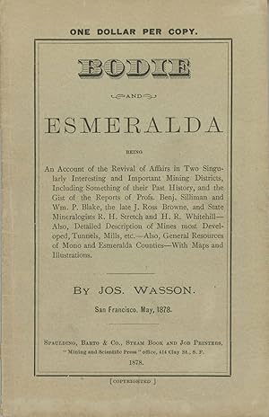
BODIE AND ESMERALDA BEING AN ACCOUNT OF THE REVIVAL OF AFFAIRS IN TWO SINGULARLY INTERESTING AND IMPORTANT MINING DISTRICTS, INCLUDING SOMETHING OF THEIR PAST HISTORY, AND THE GIST OF THE REPORTS OF PROFS. BENJ. SILLIMAN AND WM. P. BLAKE, THE LATE J. ROSS BROWNE, AND THE STATE MINERALOGISTS R. H. STRETCH AND H. R. WHITEHILL -- ALSO, DETAILED DESCRIPTION OF MINES MOST DEVELOPED, TUNNELS, MILL, ETC. -- ALSO, GENERAL RESOURCES OF MONO AND ESMERALDA COUNTIES -- WITH MAPS AND ILLUSTRATIONS. By Jos. Wasson. San Francisco, May, 1878
Verlag: Spaulding, S[an] F[rancisco], 1878
Anbieter: Currey, L.W. Inc. ABAA/ILAB, Elizabethtown, NY, USA
Verbandsmitglied: ILAB
Verkõuferbewertung 5 von 5 Sternen
Erstausgabe
18 x 11.5 cm (small octavo), pp. [1] 2-60, two inserted folded maps, four wood-engraved illustrations in the text, original gray wrappers printed in black, sewn. First edition. Two of the illustrations are full page panoramic views of Bodie and Aurora. Cowan II, p. 671. Rocq 5470. Touch of wear at spine ends, a nearly fine copy. An excellent copy of this ephemeral booklet. (#167623).
-
BODIE AND ESMERALDA BEING AN ACCOUNT OF THE REVIVAL OF AFFAIRS IN TWO SINGULARLY INTERESTING AND IMPORTANT MINING DISTRICTS, INCLUDING SOMETHING OF THEIR PAST HISTORY, AND THE GIST OF THE REPORTS OF PROFS. BENJ. SILLIMAN AND WM. P. BLAKE, THE LATE J. ROSS BROWNE, AND THE STATE MINERALOGISTS R. H. STRETCH AND H. R. WHITEHILL -- ALSO, DETAILED DESCRIPTION OF MINES MOST DEVELOPED, TUNNELS, MILL, ETC. -- ALSO, GENERAL RESOURCES OF MONO AND ESMERALDA COUNTIES -- WITH MAPS AND ILLUSTRATIONS. By Jos. Wasson. San Francisco, May, 1878
Verlag: Spaulding, S[an] F[rancisco], 1878
Anbieter: Currey, L.W. Inc. ABAA/ILAB, Elizabethtown, NY, USA
Verbandsmitglied: ILAB
Verkõuferbewertung 5 von 5 Sternen
Erstausgabe
18 x 11.5 cm (small octavo), pp. [1] 2-60, two inserted folded maps, four wood-engraved illustrations in the text, original gray wrappers printed in black, sewn. First edition. Two of the illustrations are full page panoramic views of Bodie and Aurora. Cowan II, p. 671. Rocq 5470. A nearly fine copy. An excellent copy of this ephemeral booklet. (#166765).
-
![Bild des Verkõufers f³r DATES OF LOCATION AND RECORD OF EACH CLAIM REPRESENTED ON THE MAP OF BODIE MINING DISTRICT[,] MONO COUNTY, CAL. SURVEYED AND COMPILED BY C. L. ANDERSON, C. E. ILLUSTRATED AND PUBLISHED BY EDWARD EYSEN. SAN FRANCISCO, CAL. SEPTEMBER, 1880 [cover title] zum Verkauf von Currey, L.W. Inc. ABAA/ILAB](https://pictures.abebooks.com/inventory/md/md31363104412.jpg)
DATES OF LOCATION AND RECORD OF EACH CLAIM REPRESENTED ON THE MAP OF BODIE MINING DISTRICT[,] MONO COUNTY, CAL. SURVEYED AND COMPILED BY C. L. ANDERSON, C. E. ILLUSTRATED AND PUBLISHED BY EDWARD EYSEN. SAN FRANCISCO, CAL. SEPTEMBER, 1880 [cover title]
Verlag: Crowe & Cooke, [San Francisco, 1880
Anbieter: Currey, L.W. Inc. ABAA/ILAB, Elizabethtown, NY, USA
Verbandsmitglied: ILAB
Verkõuferbewertung 5 von 5 Sternen
Erstausgabe
21.8x14.7 cm, pp. [1-11] [12: blank] (not paginated), self wrappers, sewn. First edition. The rare index to Bodie mining claims prepared to accompany an equally rare large-scale map, "Map of Bodie Mining District, Mono Co. California. Surveyed and Compiled by C. L. Anderson. Illustrated and Published by Edward Eysen, 1880," 44x61 inches, lithographed by M. Schmidt & Co., for sale by Payot, Upham & Co. The map and index were published at the height of the Bodie boom, when the town had a population of perhaps 10,000 and forty to fifty active mines and ten mills. CU-B has a photocopy of the map; the Library of Congress has (had?) the original. No libraries appear to have the index. Not in Cowan (1933) or Rocq (1970). See Phillips, p. 146 (map). Faint old vertical crease where folded for mailing, a fine copy. (#166773).
-

Eaton Land & Cattle Co. Permission Grants to Fish.
Verlag: Eaton Land and Cattle Co., (Bishop, CA), 1920
Anbieter: Nat DesMarais Rare Books, ABAA, Portland, OR, USA
Verbandsmitglied: ABAA CBA ILAB
Verkõuferbewertung 4 von 5 Sternen

One printed permission slipped, with blanks to be filled in manuscript, and a Eaton Land and Cattle Company envelope with 2 cent postage preprinted. Excellent condition.In many ways Frederick Eaton was the man responsible for the growth of Los Angeles into a mega-city. In the early part of the 20th century, Eaton and William Mulholland hit on a scheme to buy all the water rights on the Owens River in the Eastern Sierra thereby ensuring Los Angeles with the water necessary for expansion. Thet accomplished this by buying all the property along the river. In doing so Eaton, a wealthy man who had once been the mayor of Los Angeles, acquired for his own purposes a large piece of land in the Long Valley of Mono County which he called the Eaton Land & Cattle Company. The following from an Eaton family member - "The [Eaton] family issued permits for those wanting to fish on Eaton property in Long Valley-it was also to prevent the Los Angeles Department of Water and Power from interfering with Eaton irrigation projects. For a while we had armed guards.".
-
GUIDE TO BODIE[,] MONO COUNTY, CALIFORNIA . PREPARED BY E. W. BILLEB - AUG. '56 [caption title]
Verlag: Prepared by E. W. Billeb, N.p., 1956
Anbieter: Currey, L.W. Inc. ABAA/ILAB, Elizabethtown, NY, USA
Verbandsmitglied: ILAB
Verkõuferbewertung 5 von 5 Sternen
Single sheet, 38x53 cm (15 x 20 3/4 inches), printed on one side only. Map of Bodie with eleven illustrations from photographs along the top and sides, with brief text and key to locations and points of interest printed below the map. The photographs show Bodie through the years, up to 1956. The map, oriented with north toward the lower left, locates principal mines and shafts, as well as mills, commercial buildings and other structures. Now a ghost town east of the Sierra Nevada in Mono County, California, Bodie began as a mining camp of little note following the discovery of gold in 1859 by a group of prospectors, including W. S. Bodey. In 1876, the Standard Company discovered a profitable deposit of gold-bearing ore, which transformed Bodie from an isolated mining camp comprising a few prospectors and company employees to a Wild West boomtown. By 1879, Bodie had a population of approximately 7,00010,000 people and around 2,000 buildings. The town went into decline in the subsequent decades and came to be described as a "ghost town" by 1915. By 1920, Bodie's population was recorded by the US Federal Census at a total of 120 people. The town was designated a National Historic Landmark in 1961 and in 1962 the California state legislature authorized creation of Bodie State Historic Park. A total of 170 buildings remained. Today, Bodie is preserved in a state of arrested decay. Only a small part of the town survived, with about 110 structures still standing, including one of many once operational gold mills. This 1956 tourist map, produced five years prior to the town being designated a National Historic Landmark, is the earliest known map of Bodie as a ghost town. It is preceded by rare 1878 and 1880 maps of gold claims in the Bodie mining district, the equally rare 1879 birdseye view of the town, and the 1890 Sanborn-Perris fire insurance map of the town. Emil William Billeb (1885-1974) was a photographer and miner during the heyday of the Great Basin mining camps. His life and experiences in the mining camps of Nevada and eastern California after 1905 are well told in his MINING CAMP DAYS (1968), augmented with a multitude of previously unpublished photographs. Emil, who immigrated from Germany to America in 1892, married Jessie D. Cain, the daughter of Bodie pioneer James Stuart Cain (1853-1938). The Cain family eventually became Bodie's principal property owner. Tiny closed tear in top edge margin, a nearly fine copy. Professionally matted. OCLC reports one copy, at the University of California, Berkeley. (#174142).
-
GUIDE TO BODIE[,] MONO COUNTY, CALIFORNIA . PREPARED BY E. W. BILLEB - AUG. '56 [caption title]
Verlag: Prepared by E. W. Billeb, N.p., 1956
Anbieter: Currey, L.W. Inc. ABAA/ILAB, Elizabethtown, NY, USA
Verbandsmitglied: ILAB
Verkõuferbewertung 5 von 5 Sternen
Single sheet, 38x53 cm (15 x 20 3/4 inches), printed on one side only. Map of Bodie with eleven illustrations from photographs along the top and sides, with brief text and key to locations and points of interest printed below the map. The photographs show Bodie through the years, up to 1956. The map, oriented with north toward the lower left, locates principal mines and shafts, as well as mills, commercial buildings and other structures. Now a ghost town east of the Sierra Nevada in Mono County, California, Bodie began as a mining camp of little note following the discovery of gold in 1859 by a group of prospectors, including W. S. Bodey. In 1876, the Standard Company discovered a profitable deposit of gold-bearing ore, which transformed Bodie from an isolated mining camp comprising a few prospectors and company employees to a Wild West boomtown. By 1879, Bodie had a population of approximately 7,00010,000 people and around 2,000 buildings. The town went into decline in the subsequent decades and came to be described as a "ghost town" by 1915. By 1920, Bodie's population was recorded by the US Federal Census at a total of 120 people. The town was designated a National Historic Landmark in 1961 and in 1962 the California state legislature authorized creation of Bodie State Historic Park. A total of 170 buildings remained. Today, Bodie is preserved in a state of arrested decay. Only a small part of the town survived, with about 110 structures still standing, including one of many once operational gold mills. This 1956 tourist map, produced five years prior to the town being designated a National Historic Landmark, is the earliest known map of Bodie as a ghost town. It is preceded by rare 1878 and 1880 maps of gold claims in the Bodie mining district, the equally rare 1879 birdseye view of the town, and the 1890 Sanborn-Perris fire insurance map of the town. Emil William Billeb (1885-1974) was a photographer and miner during the heyday of the Great Basin mining camps. His life and experiences in the mining camps of Nevada and eastern California after 1905 are well told in his MINING CAMP DAYS (1968), augmented with a multitude of previously unpublished photographs. Emil, who immigrated from Germany to America in 1892, married Jessie D. Cain, the daughter of Bodie pioneer James Stuart Cain (1853-1938). The Cain family eventually became Bodie's principal property owner. Short tear at left edge intruding into a photo professionally mended, a very good copy. Professionally matted and shrink wrapped on acid free foamcore. OCLC reports one copy, at the University of California, Berkeley. (#166441).
![Bild des Verkõufers f³r GUIDE TO BODIE[,] MONO COUNTY, CALIFORNIA . PREPARED BY E. W. BILLEB - AUG. '56 [caption title] zum Verkauf von Currey, L.W. Inc. ABAA/ILAB](https://pictures.abebooks.com/inventory/md/md31852902144.jpg)
![Bild des Verkõufers f³r GUIDE TO BODIE[,] MONO COUNTY, CALIFORNIA . PREPARED BY E. W. BILLEB - AUG. '56 [caption title] zum Verkauf von Currey, L.W. Inc. ABAA/ILAB](https://pictures.abebooks.com/inventory/md/md31363107053.jpg)