
Gesamtpreis (1 Artikel Artikel):
Versandziel:

morden rob (30 Ergebnisse)
Direkt zu den wichtigsten Suchergebnissen
Produktart
- Alle Produktarten
- Bücher (1)
- Magazine & Zeitschriften
- Comics
- Noten
- Kunst, Grafik & Poster
- Fotografien
- Karten (29)
-
Manuskripte &
Papierantiquitäten
Zustand
- Alle
- Neu
- Antiquarisch/Gebraucht
Einband
- alle Einbände
- Hardcover
- Softcover
Weitere Eigenschaften
- Erstausgabe (3)
- Signiert
- Schutzumschlag
- Angebotsfoto
- Kein Print-on-Demand
Land des Verkäufers
Verkäuferbewertung
-
Map of The North Riding of Yorkshire.
Verlag: Abel Swale Awnsham & John Churchill, London, 1695
Karte
Zustand: Fair/poor. An antique county map by Robert Morden published in Camden's Britannia from 1695 1772, Sold by Abel Swale, Awnsham and John Churchill. Morden's name appears beneath the title in the cartouche. Condition, fair/poor as trimmed, minor dirt/staining, tear to centre and to bottom edge, some minor loss to centrefold, but hard to see exactly how much due to old support to part of down the centre only which is partly torn. Double page map of the North Riding of Yorkshire with towns, villages, woods, rivers, "minuit of time" around edges (bottom trimmed away), distance scale. Rear blank. So this map was published between 1695 and 1772 and not a modern copy that some unscrupulous dealers put a map date of say 1610 then only put hidden in the description as a modern copy/reproduction. Size: 46 x 37cm. Approx. Map.
-
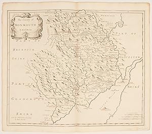
The County of Monmouth.
Verlag: LondonAbel Swale Awnsham & John Churchill., 1722
Anbieter: Robert Frew Ltd. ABA ILAB, London, Vereinigtes Königreich
Verbandsmitglied: ABA ILAB PBFA
Bewertung:

Karte
c.35 x 42 cm. (Sheet size c.39 x 45 cm.) Uncoloured double page map. Principal towns underlined in red by a contemporary hand. A very good clean example. Published in the second edition of Edmund Gibson's revision of Camden's Britannia, published London 1722.
-
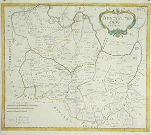
![Bild des Verkäufers für Huntington Shire [Huntingdonshire] zum Verkauf von Robert Frew Ltd. ABA ILAB](https://pictures.abebooks.com/inventory/md/md17237132818.jpg)
Huntington Shire [Huntingdonshire]
Verlag: LondonAbel Swale Awnsham & John Churchill., 1722
Anbieter: Robert Frew Ltd. ABA ILAB, London, Vereinigtes Königreich
Verbandsmitglied: ABA ILAB PBFA
Bewertung:
Karte
c.36 x 42 cm. (Sheet size c.39 x 45 cm.) Uncoloured double page map. Some of the principal locations underlined in red by a contemporary hand. Faint offsetting from being folded. A very good clean example. Published in the second edition of Edmund Gibson's revision of Camden's Britannia, published London 1722.
-
![Bild des Verkäufers für Hertford Shire [Herfordshire] zum Verkauf von Robert Frew Ltd. ABA ILAB](https://pictures.abebooks.com/inventory/md/md17237132824.jpg)
Hertford Shire [Herfordshire]
Verlag: LondonAbel Swale Awnsham & John Churchill., 1722
Anbieter: Robert Frew Ltd. ABA ILAB, London, Vereinigtes Königreich
Verbandsmitglied: ABA ILAB PBFA
Bewertung:
Karte
c.36 x 44 cm. (Sheet size c.39 x 45 cm.) Uncoloured double page map. Some of the principal locations underlined in red by a contemporary hand. A very good clean example. Published in the second edition of Edmund Gibson's revision of Camden's Britannia, published London 1722.
-
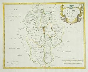
![Bild des Verkäufers für Bedford Shire [Bedfordshire] zum Verkauf von Robert Frew Ltd. ABA ILAB](https://pictures.abebooks.com/inventory/md/md17237132825.jpg)
Bedford Shire [Bedfordshire]
Verlag: LondonAbel Swale Awnsham & John Churchill., 1722
Anbieter: Robert Frew Ltd. ABA ILAB, London, Vereinigtes Königreich
Verbandsmitglied: ABA ILAB PBFA
Bewertung:
Karte
c.32 x 39 cm. (Sheet size c.39 x 45 cm.) Uncoloured double page map. Some of the principal locations underlined in red by a contemporary hand. Faint offsetting from being folded. A very good clean example. Published in the second edition of Edmund Gibson's revision of Camden's Britannia, published London 1722.
-
![Bild des Verkäufers für Hereford Shire [Herefordshire] zum Verkauf von Robert Frew Ltd. ABA ILAB](https://pictures.abebooks.com/inventory/md/md17237132827.jpg)
Hereford Shire [Herefordshire]
Verlag: LondonAbel Swale Awnsham & John Churchill., 1722
Anbieter: Robert Frew Ltd. ABA ILAB, London, Vereinigtes Königreich
Verbandsmitglied: ABA ILAB PBFA
Bewertung:
Karte
c.36 x 42 cm. (Sheet size c.39 x 45 cm.) Uncoloured double page map. Some of the principal locations underlined in red by a contemporary hand. A very good clean example. Published in the second edition of Edmund Gibson's revision of Camden's Britannia, published London 1722.
-
![Bild des Verkäufers für Stafford Shire [Staffordshire] zum Verkauf von Robert Frew Ltd. ABA ILAB](https://pictures.abebooks.com/inventory/md/md17237132830.jpg)
Stafford Shire [Staffordshire]
Verlag: LondonAbel Swale Awnsham & John Churchill., 1722
Anbieter: Robert Frew Ltd. ABA ILAB, London, Vereinigtes Königreich
Verbandsmitglied: ABA ILAB PBFA
Bewertung:
Karte
c.42 x 37 cm. (Sheet size c.45 x 39 cm.) Uncoloured double page map. Some of the principal locations underlined in red by a contemporary hand. A very good clean example. Published in the second edition of Edmund Gibson's revision of Camden's Britannia, published London 1722.
-
![Bild des Verkäufers für Worcester Shire [Worcestershire] zum Verkauf von Robert Frew Ltd. ABA ILAB](https://pictures.abebooks.com/inventory/md/md17237132831.jpg)
Worcester Shire [Worcestershire]
Verlag: LondonAbel Swale Awnsham & John Churchill., 1722
Anbieter: Robert Frew Ltd. ABA ILAB, London, Vereinigtes Königreich
Verbandsmitglied: ABA ILAB PBFA
Bewertung:
Karte
c.36 x 42 cm. (Sheet size c.39 x 45 cm.) Uncoloured double page map. A very good clean example. Published in the second edition of Edmund Gibson's revision of Camden's Britannia, published London 1722.
-
![Bild des Verkäufers für Warwick Shire [Warwickshire] zum Verkauf von Robert Frew Ltd. ABA ILAB](https://pictures.abebooks.com/inventory/md/md17237132832.jpg)
Warwick Shire [Warwickshire]
Verlag: LondonAbel Swale Awnsham & John Churchill., 1722
Anbieter: Robert Frew Ltd. ABA ILAB, London, Vereinigtes Königreich
Verbandsmitglied: ABA ILAB PBFA
Bewertung:
Karte
c.36 x 42 cm. (Sheet size c.39 x 45 cm.) Uncoloured double page map. Faint offsetting from being folded. A very good clean example. Published in the second edition of Edmund Gibson's revision of Camden's Britannia, published London 1722.
-
![Bild des Verkäufers für Nottingham Shire [Nottinghamshire] zum Verkauf von Robert Frew Ltd. ABA ILAB](https://pictures.abebooks.com/inventory/md/md17237132834.jpg)
Nottingham Shire [Nottinghamshire]
Verlag: LondonAbel Swale Awnsham & John Churchill., 1722
Anbieter: Robert Frew Ltd. ABA ILAB, London, Vereinigtes Königreich
Verbandsmitglied: ABA ILAB PBFA
Bewertung:
Karte
c.36 x 42 cm. (Sheet size c.39 x 45 cm.) Uncoloured double page map. Some of the principal locations underlined in red by a contemporary hand. Faint offsetting from being folded. A very good clean example. Published in the second edition of Edmund Gibson's revision of Camden's Britannia, published London 1722.
-
![Bild des Verkäufers für Lincoln Shire [Lincolnshire] zum Verkauf von Robert Frew Ltd. ABA ILAB](https://pictures.abebooks.com/inventory/md/md17237132836.jpg)
Lincoln Shire [Lincolnshire]
Verlag: LondonAbel Swale Awnsham & John Churchill., 1722
Anbieter: Robert Frew Ltd. ABA ILAB, London, Vereinigtes Königreich
Verbandsmitglied: ABA ILAB PBFA
Bewertung:
Karte
c.36 x 42 cm. (Sheet size c.39 x 45 cm.) Uncoloured double page map. Some of the principal locations underlined in red by a contemporary hand. A very good clean example. Published in the second edition of Edmund Gibson's revision of Camden's Britannia, published London 1722.
-
![Bild des Verkäufers für Leicester Shire [Leicestershire] zum Verkauf von Robert Frew Ltd. ABA ILAB](https://pictures.abebooks.com/inventory/md/md17237132837.jpg)
Leicester Shire [Leicestershire]
Verlag: LondonAbel Swale Awnsham & John Churchill., 1722
Anbieter: Robert Frew Ltd. ABA ILAB, London, Vereinigtes Königreich
Verbandsmitglied: ABA ILAB PBFA
Bewertung:
Karte
c.36 x 42 cm. (Sheet size c.39 x 46 cm.) Uncoloured double page map. A very good clean example. Published in the second edition of Edmund Gibson's revision of Camden's Britannia, published London 1722.
-
![Bild des Verkäufers für Northampton Shire [Northamptonshire] zum Verkauf von Robert Frew Ltd. ABA ILAB](https://pictures.abebooks.com/inventory/md/md17237132838.jpg)
Northampton Shire [Northamptonshire]
Verlag: LondonAbel Swale Awnsham & John Churchill., 1722
Anbieter: Robert Frew Ltd. ABA ILAB, London, Vereinigtes Königreich
Verbandsmitglied: ABA ILAB PBFA
Bewertung:
Karte
c.36 x 41 cm. (Sheet size c.39 x 45 cm.) Uncoloured double page map. Some of the principal locations underlined in red by a contemporary hand. A very good clean example. Published in the second edition of Edmund Gibson's revision of Camden's Britannia, published London 1722.
-
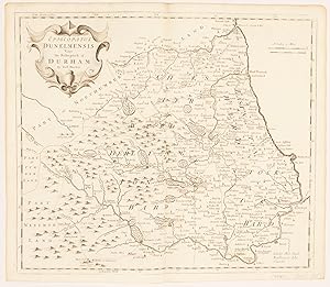
Durham.
Verlag: LondonAbel Swale Awnsham & John Churchill., 1722
Anbieter: Robert Frew Ltd. ABA ILAB, London, Vereinigtes Königreich
Verbandsmitglied: ABA ILAB PBFA
Bewertung:
Karte
c.37 x 42 cm. (Sheet size c.39 x 45 cm.) Uncoloured double page map. Some of the principal locations underlined in red by a contemporary hand. A very good clean example. Published in the second edition of Edmund Gibson's revision of Camden's Britannia, published London 1722.
-
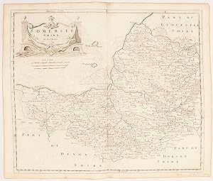
Somerset shire
Verlag: LondonAbel Swale Awnsham & John Churchill., 1722
Anbieter: Robert Frew Ltd. ABA ILAB, London, Vereinigtes Königreich
Verbandsmitglied: ABA ILAB PBFA
Bewertung:
Karte
c.36 x 43cm. (Sheet size c.39 x 45cm.) Uncoloured double page map. Some of the principal locations underlined in red by a contemporary hand. A very good clean example. Published in the second edition of Edmund Gibson's revision of Camden's Britannia, published London 1722.
-
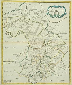
![Bild des Verkäufers für Cambridge Shire [Cambridgeshire] zum Verkauf von Robert Frew Ltd. ABA ILAB](https://pictures.abebooks.com/inventory/md/md17237132819.jpg)
Cambridge Shire [Cambridgeshire]
Verlag: LondonAbel Swale Awnsham & John Churchill., 1722
Anbieter: Robert Frew Ltd. ABA ILAB, London, Vereinigtes Königreich
Verbandsmitglied: ABA ILAB PBFA
Bewertung:
Karte
c.42 x 36 cm. (Sheet size c.44 x 39 cm.) Uncoloured double page map. Some of the principal locations underlined in red by a contemporary hand. A very good clean example. Published in the second edition of Edmund Gibson's revision of Camden's Britannia, published London 1722.
-
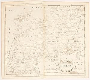
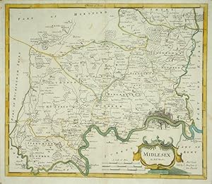
Middlesex.
Verlag: LondonAbel Swale Awnsham & John Churchill., 1722
Anbieter: Robert Frew Ltd. ABA ILAB, London, Vereinigtes Königreich
Verbandsmitglied: ABA ILAB PBFA
Bewertung:
Karte
c.36 x 42 cm. (Sheet size c.39 x 45 cm.) Uncoloured double page map. Some of the principal locations underlined in red by a contemporary hand. A very good clean example. Published in the second edition of Edmund Gibson's revision of Camden's Britannia, published London 1722.
-

South Wales.
Verlag: LondonAbel Swale Awnsham & John Churchill., 1722
Anbieter: Robert Frew Ltd. ABA ILAB, London, Vereinigtes Königreich
Verbandsmitglied: ABA ILAB PBFA
Bewertung:
Karte
c.36 x 43 cm. (Sheet size c.39 x 45 cm.) Uncoloured double page map. Some of the principal locations underlined in red by a contemporary hand. Outer edges slightly worn not affecting the map itself, light foxing. Published in the second edition of Edmund Gibson's revision of Camden's Britannia, published London 1722.
-
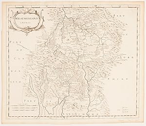
Westmoreland.
Verlag: LondonAbel Swale Awnsham & John Churchill., 1722
Anbieter: Robert Frew Ltd. ABA ILAB, London, Vereinigtes Königreich
Verbandsmitglied: ABA ILAB PBFA
Bewertung:
Karte
c.36 x 43 cm. (Sheet size c.39 x 45 cm.) Uncoloured double page map. Some of the principal locations underlined in red by a contemporary hand. A very good clean example. Published in the second edition of Edmund Gibson's revision of Camden's Britannia, published London 1722.
-

England.
Verlag: LondonAbel Swale Awnsham & John Churchill., 1722
Anbieter: Robert Frew Ltd. ABA ILAB, London, Vereinigtes Königreich
Verbandsmitglied: ABA ILAB PBFA
Bewertung:
Karte
c.36 x 42 cm. (Sheet size c.39 x 45 cm.) Uncoloured double page map. A very good clean example. Published in the second edition of Edmund Gibson's revision of Camden's Britannia, published London 1722.
-
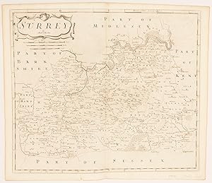
Surrey
Verlag: London Abel Swale Awnsham & John Churchill., 1722
Anbieter: Robert Frew Ltd. ABA ILAB, London, Vereinigtes Königreich
Verbandsmitglied: ABA ILAB PBFA
Bewertung:
Karte
c.36 x 42cm. (Sheet size c.39 x 45cm.) Uncoloured double page map. Some of the principal locations underlined in red by a contemporary hand. Small tear to lower left edge, slight paper loss not affecting map. A very good clean example. Published in the second edition of Edmund Gibson's revision of Camden's Britannia, published London 1722.
-
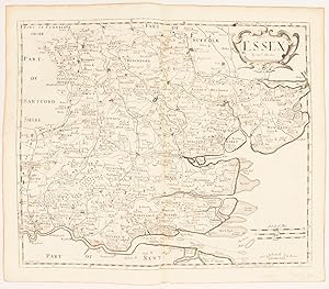
Essex
Verlag: LondonA.Swale A.Churchill & Partner., 1722
Anbieter: Robert Frew Ltd. ABA ILAB, London, Vereinigtes Königreich
Verbandsmitglied: ABA ILAB PBFA
Bewertung:
Karte
c.36 x 42 cm. (Sheet size c.39 x 45 cm.) Uncoloured double page map. Some of the principal locations underlined in red by a contemporary hand. A very good clean example. Published in the second edition of Edmund Gibson's revision of Camden's Britannia, published London 1722.
-
Huntingtonshire.
Verlag: LondonAbel Swale Awnsham & John Churchill., 1695
Anbieter: Robert Frew Ltd. ABA ILAB, London, Vereinigtes Königreich
Verbandsmitglied: ABA ILAB PBFA
Bewertung:
Karte
35.1 x 41.8 cm. Double page map of the county of Huntingdonshire, shown divided into hundreds. Original outline colour to the boundaries of the hundreds and the county, original colour also to the title cartouche and the map border. Blank on verso. Small hole to left edge very neatly filled, otherwise in very good condition.
-
Bedfordshire.
Verlag: LondonAbel Swale Awnsham & John Churchill., 1695
Anbieter: Robert Frew Ltd. ABA ILAB, London, Vereinigtes Königreich
Verbandsmitglied: ABA ILAB PBFA
Bewertung:
Karte Erstausgabe
31.8 x 39.7 cm. Double page map of the county of Bedfordshire, shown divided into hundreds. Original outline colour to the boundaries of the hundreds and the county, original colour also to the large title catouche and the map border. Blank on verso. Small crack sometime neatly reinforced on verso, otherwise in good condition. Another area repaired on verso, consequently affecting adjacent outline colour. Published in the first edition of Edmund Gibson's revision of Camden's Britannia.
-
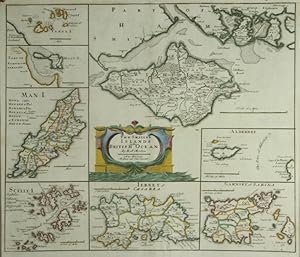
The Smaller Islands in the British Ocean.
Verlag: LondonAbel Swale Awnsham & John Churchill., 1695
Anbieter: Robert Frew Ltd. ABA ILAB, London, Vereinigtes Königreich
Verbandsmitglied: ABA ILAB PBFA
Bewertung:
Karte
Overall image size 35.5 x 41.8 cm. Eight maps of varying dimensions on one double page sheet, comprising maps of the Isle of Wight, Alderney, Guernesey (including Sark), Jersey, the Isles of Scilly, the Isle of Man, Holy Island and the Farne Islands. Orginal outline colour to the maps, also orginal colour to the central title cartouche. Blank on verso. A few small areas of offsetting from original colour. Upper margin expertly restored (the engraved area unaffected), otherwise in very good condition.
-
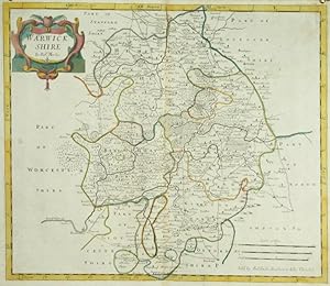
Warwickshire.
Verlag: LondonAbel Swale Awnsham & John Churchill., 1695
Anbieter: Robert Frew Ltd. ABA ILAB, London, Vereinigtes Königreich
Verbandsmitglied: ABA ILAB PBFA
Bewertung:
Karte Erstausgabe
36 x 42.2 cm. Double page map of Warwickshire divided into hundreds. Original outline colour to the boundaries of the hundreds and the county, original colour also to the title catouche and the the map border. Blank on verso. Very faint browning along the centrefold, otherwise a very good example. Published in the first edition of Edmund Gibson's revision of Camden's Britannia.
-
Cambridgeshire.
Verlag: LondonAbel Swale Awnsham & John Churchill., 1695
Anbieter: Robert Frew Ltd. ABA ILAB, London, Vereinigtes Königreich
Verbandsmitglied: ABA ILAB PBFA
Bewertung:
Karte Erstausgabe
41.9 x 35.6 cm. Double page map of the county of Cambridgeshire, shown divided into hundreds. Original outline colour to the boundaries of the hundreds and the county, original colour also to the title catouche and the map border. Blank on verso. Very lightly browned along centrefold, otherwise in very good condition. Published in the first edition of Edmund Gibson's revision of Camden's Britannia.
-
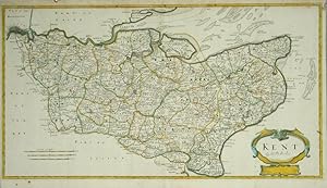
Kent.
Verlag: London Abel Swale Awnsham & John Churchill., 1695
Anbieter: Robert Frew Ltd. ABA ILAB, London, Vereinigtes Königreich
Verbandsmitglied: ABA ILAB PBFA
Bewertung:
Karte
34.6 x 63.6 cm. Attractive map of the county of Kent, shown divided into hundreds. Original outline colour to the boundaries of the hundreds and the county, original colour also to the title cartouche and the map border. Blank on verso. Traces of old vertical folds, though fairly inconspicuous. Upper margin neatly restored. Tear at lower margin expertly repaired, otherwise in very good condition.
-
Midlesex.
Verlag: LondonAbel Swale Awnsham & John Churchill., 1695
Anbieter: Robert Frew Ltd. ABA ILAB, London, Vereinigtes Königreich
Verbandsmitglied: ABA ILAB PBFA
Bewertung:
Karte
36.3 x 42 cm. Double page folio map of the county of Middlesex. Original outline colour to the boundaries of the hundreds and the county, original colour also to the title cartouche and the map border. Blank on verso. Small crack to paper with very slight loss to image at lower right corner. The sheet expertly laid down on japan paper reinforcing said crack, otherwise in good condition.
-
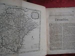
Devonshire, hrsg. Cox`s Co, Devon, 1720, EA, m. gefalteter Landkarten Devonshire von Rob. Morden u. ca. 75 S Text (in Englisch) = detailierte Beschreibung d. Districtes Devonshire. Ppbd d. Zt. gr 8°, Rü tlw. m. Fehlstellen, guter Zustand, rare Ausgabe! Best.Nr.18046 Sprache: Deutsch Gewicht in Gramm: 400.
