Gesamtpreis (1 Artikel Artikel):
Versandziel:

nicolaes visscher (191 Ergebnisse)
Produktart
- Alle Product Types
- Bücher (121)
- Magazine & Zeitschriften
- Comics
- Noten
- Kunst, Grafik & Poster (23)
- Fotografien
- Karten (47)
- Manuskripte & Papierantiquitäten
Zustand
Einband
Weitere Eigenschaften
- Erstausgabe (7)
- Signiert (1)
- Schutzumschlag (2)
- Angebotsfoto (124)
- Keine Print-on-Demand Angebote (188)
Gratisversand
- Versand nach USA gratis
Land des Verkäufers
Verkäuferbewertung
-
![Bild des Verkäufers für Verscheyde schoone en vermaakelyke gezigten in de hofstede van Clingendaal gelegen by 's Gravenhage : naa t'leven getekent en in t'kooper gebrugt [LeatherBound] zum Verkauf von True World of Books](https://pictures.abebooks.com/inventory/md/md31534022751.jpg)
LeatherBound. Zustand: New. LeatherBound edition. Condition: New. Reprinted from 1679 edition. Leather Binding on Spine and Corners with Golden leaf printing on spine. Bound in genuine leather with Satin ribbon page markers and Spine with raised gilt bands. A perfect gift for your loved ones. NO changes have been made to the original text. This is NOT a retyped or an ocr'd reprint. Illustrations, Index, if any, are included in black and white. Each page is checked manually before printing. As this print on demand book is reprinted from a very old book, there could be some missing or flawed pages, but we always try to make the book as complete as possible. Fold-outs, if any, are not part of the book. If the original book was published in multiple volumes then this reprint is of only one volume, not the whole set. Sewing binding for longer life, where the book block is actually sewn (smythe sewn/section sewn) with thread before binding which results in a more durable type of binding. Pages: 72 Language: Dutch.
-
![Bild des Verkäufers für Afbeeldinghe der voornaemste steden van Europa. (1660) [Leatherbound] zum Verkauf von S N Books World](https://pictures.abebooks.com/inventory/md/md30877576612.jpg)
Afbeeldinghe der voornaemste steden van Europa. (1660) [Leatherbound]
Erscheinungsdatum: 2022
Buch Print-on-Demand
LeatherBound. Zustand: NEW. Leatherbound edition. Condition: New. Leather Binding on Spine and Corners with Golden leaf printing on spine. Bound in genuine leather with Satin ribbon page markers and Spine with raised gilt bands. A perfect gift for your loved ones. Reprinted from 1660 edition. NO changes have been made to the original text. This is NOT a retyped or an ocr'd reprint. Illustrations, Index, if any, are included in black and white. Each page is checked manually before printing. As this print on demand book is reprinted from a very old book, there could be some missing or flawed pages, but we always try to make the book as complete as possible. Fold-outs, if any, are not part of the book. If the original book was published in multiple volumes then this reprint is of only one volume, not the whole set. IF YOU WISH TO ORDER PARTICULAR VOLUME OR ALL THE VOLUMES YOU CAN CONTACT US. Resized as per current standards. Sewing binding for longer life, where the book block is actually sewn (smythe sewn/section sewn) with thread before binding which results in a more durable type of binding. Pages: 54 Language: Dutch Pages: 54.
-
![Bild des Verkäufers für Speculum Zelandiae : dat is, een beschryvinge ofte afbeelding der steden, ambachts-heerlijckheden, dorpen, castelen, ridderlijcke hofsteden, huysen en gebouwen, gelegen inde eylanden en de graeflijckheyt van Zeelandt / bij een vergadert door Nicolaus Visscher. (1660) [Leatherbound] zum Verkauf von S N Books World](https://pictures.abebooks.com/inventory/md/md30877580098.jpg)
Speculum Zelandiae : dat is, een beschryvinge ofte afbeelding der steden, ambachts-heerlijckheden, dorpen, castelen, ridderlijcke hofsteden, huysen en gebouwen, gelegen inde eylanden en de graeflijckheyt van Zeelandt / bij een vergadert door Nicolaus Visscher. (1660) [Leatherbound]
Erscheinungsdatum: 2022
Buch Print-on-Demand
LeatherBound. Zustand: NEW. Leatherbound edition. Condition: New. Leather Binding on Spine and Corners with Golden leaf printing on spine. Bound in genuine leather with Satin ribbon page markers and Spine with raised gilt bands. A perfect gift for your loved ones. Reprinted from 1660 edition. NO changes have been made to the original text. This is NOT a retyped or an ocr'd reprint. Illustrations, Index, if any, are included in black and white. Each page is checked manually before printing. As this print on demand book is reprinted from a very old book, there could be some missing or flawed pages, but we always try to make the book as complete as possible. Fold-outs, if any, are not part of the book. If the original book was published in multiple volumes then this reprint is of only one volume, not the whole set. IF YOU WISH TO ORDER PARTICULAR VOLUME OR ALL THE VOLUMES YOU CAN CONTACT US. Resized as per current standards. Sewing binding for longer life, where the book block is actually sewn (smythe sewn/section sewn) with thread before binding which results in a more durable type of binding. Pages: 136 Language: Dutch Pages: 136.
-
The World Map of 1669 / by Jodocus Hondius the Elder and Nicolaes Visscher ; Gunter Schilder
Verlag: Amsterdam : N. Israel, 1978
ISBN 10: 9060721195ISBN 13: 9789060721193
Buch
1st Edition in this form. Fine paperback copy. Particularly and surprisingly well-preserved; tight, bright, clean and especially sharp-cornered.; 8vo 8" - 9" tall; 0 pages; Description: 35 leaves, 20 leaves of plates : ill., maps ; 56 cm. Includes bibliographical references. Reprint of the 1669 map by J. Hondius, as updated by C. J. Visscher, published by N. Visscher, Amsterdam. Title of original map reads: Novissima ac exactissima totius orbis terrarum descriptio magna. Series: Wall-maps of the 16th and 17th centuries ; 2. Subjects: World maps --Early works to 1800. Early maps. 3 Kg.
-

Gerardi de Lairesse, Leodiensis pictoris Opus elegantissimum
Verlag: Creative Media Partners, LLC Aug 2016, 2016
ISBN 10: 1363078704ISBN 13: 9781363078707
Buch
Taschenbuch. Zustand: Neu. Neuware - This work has been selected by scholars as being culturally important, and is part of the knowledge base of civilization as we know it. This work was reproduced from the original artifact, and remains as true to the original work as possible. Therefore, you will see the original copyright references, library stamps (as most of these works have been housed in our most important libraries around the world), and other notations in the work.
-

Two etchings after Berchem and Cornelis Visscher: 'Landscape with woman seated surrounded by farm animals' and 'Resting place' where travellers rest beside a fountain. Compositions mirrored in respect to the originals, slightly larger including address of the publisher. Plates numbered above on the left: 'T.20' and in the middle: 'VIII', addresses at the bottom:'Negotium Caesarea Franciscae AA.LL. Academiae excudit / Cum Gratia et Privilegio S.C. Majestatis.' thus these paltes were issued in Augsburg in the second hlaf of the eighteenth century. l Etching and engraving on paper, trimmed to plate mark: total: 188 x 293 mm and 195 x 300 mm; damp stains and foxing, first plate paper rather cooked; both are not described in Hollstein.
-
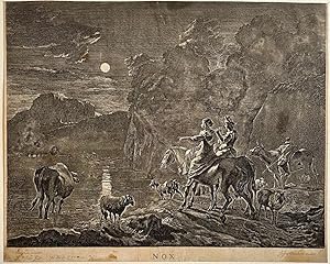
Antique print, etching and engraving I Nox (Nacht scene), published ca. 1680, 1 p.
Anbieter: Antiquariaat Arine van der Steur / ILAB, Den Haag, Niederlande
Bewertung:

From a set of the times of the day: Night.A moonlit landscape with a shepherd couple on horseback by the banks of a lake with their flock.Titled at bottom center: NOXSigned below: CBerghem inventor. / J. Vißcher fecit // Justus Danckerts Excudit.[NL] Gezicht op een heuvelachtig landschap bij nacht. De volle maan schijnt. Een herder en herderin te paard laten hun vee drinken uit een meer. Op de achtergrond een man in een bootje en de contouren van een dorp. Gemaakt door Johannes Visscher. Etching and engraving on paper, trimmed within plate mark; total: 296 x 363 mm; some spores, staining on the bottom especially; in fair condition. Hollstein 4.
-
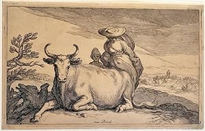
Antique print, etching and engraving | A reclining cow and a woman, published ca. 1650, 1 p.
Anbieter: Antiquariaat Arine van der Steur / ILAB, Den Haag, Niederlande
Bewertung:
A reclining cow. Behind the cow a woman with summer hat and a child. In the background to the right a village in the distance.Print from a series of 14 prints depicting various animals.Inscribed at bottom: met Privil. Numbered on the bottom right corner: 3.[NL] Een liggende koe. Achter de koe een vrouw met zomerhoed en een kind. Prent uit een serie van 14 prenten met verschillende inheemse dieren. Antieke prent gemaakt door Frederick Bloemaert. Etching and engraving on paper, trimmed close to plate; total: 99 x 160 mm; state I/2; Evenly yellowed paper, traces of handling, damage on the bottom right corner. Overall in fair condition. Hollstein 16-29.
-
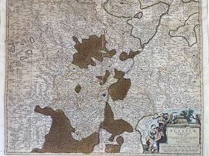
"Landgraviatus Alsatiae inferioris Novissima Tabula." - Elsass Alsatia Baden - 1661-1680. Kolorierter Kupferstich.
Verlag: Amsterdam, Visscher, 1680
Buch Erstausgabe
Kupferstich, Koloriert. 1 Bll., Koloriert, Darstellungsgröße, 56 x 46 cm Karte in noch guter Erhaltung. Karte sauber. Zum Randbereich stellenweise ein wenig gewellt. Leichte Lagerspuren vor vormaliger Faltung der Karte sichtbar. Im unteren, linken Kartenbereich mit hinterlegten, gering sichbaren Einriss. Sprache: Deutsch Gewicht in Gramm: 1050.
-

Beautiful frontispiece to a series of four plates aftre Nicolaes Berchem by Johannes Visscher. Mounted on a larger plain leaf, very mirno chipping at top right, minor foxing spots at lower left corner, overall a very good copy and fine impression. Suitable for framing or perhaps mating with original. Scarce state with Petrus Schenk listed as publisher. Citations: BM 1839, 0413.389.
-
![Bild des Verkäufers für [Antique print, etching] Shephard playing the bagpipe/Schaapsherder bespeelt een soort doedelzak, ca 1650-1700. zum Verkauf von Antiquariaat Arine van der Steur / ILAB](https://pictures.abebooks.com/inventory/md/md30796890761.jpg)
[Antique print, etching] Shephard playing the bagpipe/Schaapsherder bespeelt een soort doedelzak, ca 1650-1700.
Anbieter: Antiquariaat Arine van der Steur / ILAB, Den Haag, Niederlande
Bewertung:
From a set of four plates, oriented upright, representing shepherds and shepherdesses on their paths to meadows, across water streams. Here a herd playing the bagpipe sitting under a tree. All around him, cattle and his flock, with a woman and a young child drinking from a bowl. No letters and no numbers. On verso, collector's mark of 'PICTURA' in Groningen [L. 2028]. Etching on paper, trimmed within and to plate mark; total: 273 x 224 mm; state I/4; rather browned paper, small hole towards the top; foxing visible on verso; dirt on the front. Watermark with fool's cap. Hollstein 63, Wess. 93.
-
![Bild des Verkäufers für [Antique print, etching] Herd, dog and three cows crossing a ford/ Kudde schapen, hond en drie koeien die een doorwaadbare plaats oversteken, ca 1650-1700. zum Verkauf von Antiquariaat Arine van der Steur / ILAB](https://pictures.abebooks.com/inventory/md/md30796892616.jpg)
From a set of four plates, oriented upright, representing shepherds and shepherdesses on their paths to meadows, across water streams. Here a herd with a dog and three cows are crossing a ford. No letters and no numbers. On verso, collector's mark of 'PICTURA' in Groningen [L. 2028]. Etching on paper, trimmed within and close to plate mark; total: 178 x 229 mm; state I/4; browned paper, tear on the right margins, repaired with tape; dirt on the surface of the print; notes in pen and pencil on verso. Hollstein 64, Wess. 94.
-
![Bild des Verkäufers für [Antique print, etching] A girl carrying a bucket, published ca. 1650-1700, 1 p. zum Verkauf von Antiquariaat Arine van der Steur / ILAB](https://pictures.abebooks.com/inventory/md/md30796892617.jpg)
[Antique print, etching] A girl carrying a bucket, published ca. 1650-1700, 1 p.
Anbieter: Antiquariaat Arine van der Steur / ILAB, Den Haag, Niederlande
Bewertung:
From a set of four plates, representing scenes of herding. Here, a young woman is carrying a bucket. Beside her, a cow, sheep and goats.Numbered and signed at bottom: 'Berchem delin / J. Visscher fe. /2'.On verso, collector's mark of Pim van Eekelen [L. 5101].[NL] Meisje met emmer. Berglandschap met een jonge vrouw met een emmer tussen het vee. De vrouw loopt op blote voeten. Etching on paper, trimmed to plate mark; total: 154 x 202 mm; state II/2; in very good condition; paper watermark with Amsterdam's coat of arms. Hollstein 74, Wess. 103.
-
![Bild des Verkäufers für [Portrait print of Koning Karel II van Spanje] CAROLUS SECUNDUS HISPANIARUM ET INDIARUM REX, 1650-1700. zum Verkauf von Antiquariaat Arine van der Steur / ILAB](https://pictures.abebooks.com/inventory/md/md30810662906.jpg)
[Portrait print of Koning Karel II van Spanje] CAROLUS SECUNDUS HISPANIARUM ET INDIARUM REX, 1650-1700.
Anbieter: Antiquariaat Arine van der Steur / ILAB, Den Haag, Niederlande
Bewertung:
Half-length portrait of Charles II, King of Spain & the Indies (1661-1700) in armor, turned towards left. Titled below: "CAROLUS SECUNDUS / HISPANIARUM ET INDIARUM REX." inscribed below: "Cum Gratia et Privilegio Ordinum Holl. et Est-Frisiae. / Ex Formis N. Visscher". Engraving on paper with margins; plate mark: 368 x 278 mm, total: 383 x 289 mm; some mold on the left portion of the portrait; small stain below; piece of paper popping from the lower border; some dirt due to handling.
-

"Leodiensis Episcopatus im omnes subjacentes Provincias distincte divisus" - Liege Leuven Namur Dinant Aachen Düren Trier Jülich Limburg
Verlag: Amsterdam ca. 1650., 1650
Anbieter: Antiquariat Steffen Völkel GmbH, Seubersdorf, Deutschland
Bewertung:
Karte
Großformatige altkolorierte Kupferstich-Karte von ca. 1650. Rückseitig ohne Text. -- Blatt-Maße: ca. 53 x 61 cm. -- im unteren Mittelbug leicht eingerissen, sonst gut erhalten. || Large old colored engraved map from c. 1650. Without text on verso. -- slightly split on the lower part of the centerfold, otherwise in good condition. || Dies ist ein Original! - Kein Nachdruck! - Keine Kopie! -- This is an original! - No copy! - No reprint! la Gewicht in Gramm: 1550.
-
Hardcover. Zustand: very good. Flandriae Comitatus, map, anno 1690, Visscher N., size of the leaf: 52x62 cm., little brownish, restoration on below centerfold,
-
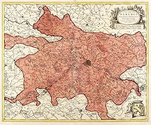
Zustand: guter Zustand. Belgien. Grafschaft Namur. Visscher. Comitatus Namurci Emendata Delineatio.Um 1660. Kupferstich, alt koloriert. Historische Landkarte, von Nicolaes Visscher d.Ä. 47,3 x 56,9, cm (Darstellung / Platte), 51 x 62,5 cm (Blatt).Blatt im Bereich der mittigen Bindefalte mit Einrissen und teils ausgedünntem Papier. Kleinere Einrisse auch im Randbereich. Insgesamt aber guter Zustand.Nicolaes Visscher d.Ä. (1618 - 1679 Amsterdam). Niederländischer Kupferstecher, Kartograph und Verleger, Mitglied der von seinem Vater Claes Janszoon Visscher begründeten niederländischen Kunsthändler-, Kupferstecher- und Verleger-Dynastie. Übernahm 1652 den Kunstverlag des Vaters und setzte die Atlanten- und Kartenwerke fort. Stach mit seinem Sohn Nicolaes Visscher d.J. zahlreiche eigene Druckplatten für die Atlanten Atlas Contractus, Atlas Minor und Germania Inferior. Rechts oben Titelkartusche mit Angabe des Autoren, darunter Entfernungsmaßstäbe. Rechts unten Wappen mit Legende. 47,3 x 56,9, cm (Darstellung / Platte), 51 x 62,5 cm (Blatt).
-
"Superioris Alsatiae nec non Brisigaviae et Suntgaviae Geographica Tabula".
Verlag: Amsterdam: Nicolaes Visscher, 1652., 1652
Single sheet (22 Ľ x 19 ˝) Full margins showing the plate mark. (Light browning to edge). A fine large hand-colored map of the Alsace region and the Rhine River valley. The map includes the fortified cities of Colmar, Freiburg, Breisach, Basle and Schaffhausen. Alsace is an area and a former region in the east of France. The capital is Strasbourg. It is subdivided in the departments Haut-Rhin and Bas-Rhin. The region became part of Alsace-Champagne-Ardenne-Lorraine when the area was re-divided in January 2016. The lefthand side is decorated with a fine (fully colored) figural cartouche featuring a soldier, river gods, putti and a vineyard. The cartouche clearly pays homage to Roman Alsace (c. 60 BC), when the Romans had invaded and established Alsace as the center of viticulture. In order to protect this highly valued industry, the Romans built fortifications and military camps that evolved into various communities which have been inhabited continuously to the present day. While part of the Roman Empire, Alsace was part of Germania Superior. The Atlas Minor is a fine and comprehensive composite atlas, and one of a series of large atlases compiled and sold by the Visscher family of art dealers and cartographers in the 17th century. Founded by Nicholas Visscher, this work is known for the high quality of engraving, exceptionally fine ornament, and accurate geographical information. No two of the Visscher atlases seem to have been identical in content, and most contain, like this one, a selection of maps by the Visschers themselves as well as other cartographers. In this case the majority of the maps are published by Visscher. In addition to the striking world map by Allard with its black background and numerous projections, and found in the "Atlas Major" from about 1705, there are maps of the continents, regional maps of Europe, ten maps of Asia, and seven maps related to America. For more information on this map, or a warm welcome to see other maps and books of our collection at 72nd Street NYC, please contact Natalie Zadrozna.
-
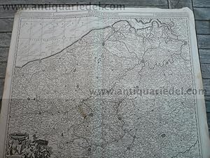
"Novissima et accuratissima XVII Provinciarum Germaniae Inferioris tabula".
Verlag: Amsterdam: Nicolaes Visscher, c 1690., 1690
Single sheet (22 Ľ x 19 ˝) Full margins showing the plate mark. (Light foxing, repair on verso). An excellent hand-colored map of Belgium, Netherlands and Luxembourg with decorative title cartouche and cartouche of explanations and dedication. North orientated to the right. The map exhibits a stunning hand-coloring with a good oxidation on verso. As with Visscher maps, it is decorated to the highest degree with elegant cartouches, landscape, and color. Right side bears the title cartouche embellished with several figures, namely Athena Demeter, and a caveman. Left side cartouche contains a key guide to the map, with all the Provinces listed and enumerated. Below the guide there is an inscribed dedication to Johannes Munter (1622-1685), Mayor of Amsterdam. Nearly all Dutch provinces can trace their origin to a medieval county or duchy, as can the provinces of regions in Belgium. Their status changed when they came under a single ruler who centralised their administration, reducing their powers. There were 17 in total: from these unified Netherlands, seven northern provinces formed from 1588 the Republic of the Seven United Provinces in the 17th century, namely Holland, Zeeland, Gelderland, Utrecht, Friesland, Overijssel and Groningen. The Republic's lands also included Drenthe (one of the 17, but without the autonomous status of the others), and parts of Brabant, Limburg and Flanders, which were considered to be "conquered lands" and were governed directly by the Staten-Generaal, the parliament, hence their name Generality Lands. They were called Staats-Brabant, Staats-Limburg and Staats-Vlaanderen, meaning "state-owned". Each of these "Netherlands" had a high degree of autonomy, cooperating with each other mainly on defense and foreign relations, but otherwise keeping to their own affairs. The Atlas Minor is a fine and comprehensive composite atlas, and one of a series of large atlases compiled and sold by the Visscher family of art dealers and cartographers in the 17th century. Founded by Nicholas Visscher, this work is known for the high quality of engraving, exceptionally fine ornament, and accurate geographical information. No two of the Visscher atlases seem to have been identical in content, and most contain, like this one, a selection of maps by the Visschers themselves as well as other cartographers. In this case the majority of the maps are published by Visscher. In addition to the striking world map by Allard with its black background and numerous projections, and found in the "Atlas Major" from about 1705, there are maps of the continents, regional maps of Europe, ten maps of Asia, and seven maps related to America. For more information on this map, or a warm welcome to see other maps and books of our collection at 72nd Street NYC, please contact Natalie Zadrozna.
-

Geographica Artesiae Comitatus Tabula. Map of part of the northeast region of Artois in France, reaching from Calais inland to Douay, Bapaume and Montreuil.
Verlag: Amsterdam, 1685
Anbieter: BALAGUÉ LLIBRERÍA ANTIQUŔRIA, Santa Coloma de Farners, GIRON, Spanien
Bewertung:
Karte Erstausgabe
Sin Encuadernar. Zustand: Bien. Nicolaes Visscher I (1618 -1679) (illustrator). 1Ş Edición. 61 x 53 cm. Iluminado a mano de época.
-

Comitatus Hannoniae Tabula, emendata per Alexandrum Penez
Verlag: Amsterdam, 1685
Anbieter: BALAGUÉ LLIBRERÍA ANTIQUŔRIA, Santa Coloma de Farners, GIRON, Spanien
Bewertung:
Karte Erstausgabe
Sin Encuadernar. Zustand: Bien. Nicolaes Visscher I (1618 -1679) (illustrator). 1Ş Edición. 61 x 53 cm. Iluminado a mano de época.
-
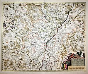
No Binding. Zustand: Good. Cooper engraving, 49.0 x 54.5 cm on paper 54 x 63.5 cm, with old color in outline (minor spotting and creasing, remnants of the centerfold). A good copy of a map of the north-eastern part of Flanders featuring the mouth of the Scheldt by Dutch cartographer and publisher Nicolaes Visscher (1618-1709).
-
GRAAFSCHAP ARTESIË (ARTOIS) "Geographica Artesiae Comitatus Tabula", kopergravure uitgegeven te Amsterdam door Nicolaes Visscher I als deel van diens "Atlas Contractus" tussen 1656-1677
Anbieter: Inter-Antiquariaat Mefferdt & De Jonge, Amsterdam, Niederlande
Bewertung:
Kunst / Grafik / Poster
GRAAFSCHAP ARTESIË (ARTOIS) "Geographica Artesiae Comitatus Tabula", kopergravure uitgegeven te Amsterdam door Nicolaes Visscher I als deel van diens "Atlas Contractus" tussen 1656-1677. Verso: blank. In de tijd met de hand gekleurd. Afm. 46,6 x 56,3 cm. Het Graafschap Artesië was een van de Zeventien Provinciën in de 16e eeuw. Artesië speelde een belangrijke rol aan het begin van de Tachtigjarige Oorlog. Samen met Henegouwen nam Artesië het initiatief tot de zuidelijke Unie van Atrecht (Arras). Hoewel de Vlaamse en Brabantse steden de kant van de noordelijke Unie van Utrecht kozen, was de scheuring van de Nederlanden begonnen, met een noordelijk deel dat streefde naar onafhankelijkheid van de Spaanse koning en een zuidelijk deel dat bij het Spaanse rijk wilde blijven. Aan het eind van de Tachtigjarige Oorlog werd Artesië op de Spanjaarden veroverd door de Fransen. Bij de Vrede van de Pyreneeën in 1659 werd Artesië definitief aan Frankrijk toegewezen. Rechts boven dragen putti een banderol met daarop de titel van de kaart en het wapen van het graafschap. Een dromerige putto met passer rust op de legenda en schaalstokken rechtsonder. Prijs: Euro 175,-.
-
Copper engraving shows Gdansk in Poland, surrounded by a decorative cartouche. The view was published in the first edition of 'Afbeeldinghe der Voornaemste Steden van Europa' in Amsterdam in 1666/1667. The work containing a frontispiece and 24 city views was reprinted up to the late 17th century. The engravings were made by Nicolaes Visscher (1618-1679) and Pieter Hendricksz. Schut (ca. 1618-na. 1666). They were bades upon drafts by a famous Dutch artist Nicolaes Pieterszoon Berchem (1620 -1683). Berchem also active as engraver, was a son of the painter Pieter Claesz (c. 1597-1660). The views are rare on the market. First state without number. References: Hollstein 129. ______________ Seltene Ansicht von Danzig in dekorativer Kartusche mit Personnenstaffage vorne. Kupferstich wurde herausgegeben in Amsterdam 1666/1667 in der ersten Ausgabe des seltenen Werkes mit Titelblatt und 24 Stadtansichten 'Afbeeldinghe der Voornaemste Steden van Europa'. Die Ansichten wurden gestochen voner (1618-1679) und Pieter Hendricksz. Schut (ca. 1618-na. 1666) nach den Entwurfen des berühmten Malers Nicolaes Pieterszoon Berchem (1620 -1683). Der ein niederländischer Zeichner, Graphiker und Landschaftsmaler Berchem war der Sohn von Pieter Claesz (c. 1597-1660). Das Werk wurde nachgedruckt am Ende des 17. Jahrhunderst von Friedrick de Wit. Die Ansichten aus dem Werk sind selten. 1. Zustand vor nummerierung. Winzige Risse im Rand, insgesamt gut erhalten. - Hollstein 129.
-

Regnum Bohemiae et que annexe provinciae ut Cucatus Silesiae Marchionatus Moravie et Lusatiae, vulgo die Erb-Landeren.
Verlag: Amsterdam, 1650
Anbieter: BALAGUÉ LLIBRERÍA ANTIQUŔRIA, Santa Coloma de Farners, GIRON, Spanien
Bewertung:
Karte Erstausgabe
Sin Encuadernar. Zustand: Bien. Nicolaes Visscher (1618 -1679) (illustrator). 1Ş Edición. 63 x 53 cm. Iluminado a mano de época.
-
TABULA DUCATUS BRABANTIAE continens Marchionatum Sacri Imperii et Dominium Mechliniense de novo accuratč emendata et in lucem edita Per Nicolaum I. Piscatorem.
Verlag: S/data. [Ed. Claes Ianß Vißcher. Amsterdam, ca. 1670, 1670
Anbieter: Libreria Anticuaria Farré, Barcelona, BARCE, Spanien
Bewertung:

]. 50 x 60 cm. Grabado a color. Restauraciones antiguas. Varias rasgaduras en el margen superior. Papel algo tostado. Pertenece a la colección de mapas ?Universum Totale, Sive Rerum Visibilium Compendium? OCLC 165832322. Bélgica y Países Bajos.
-
"Landgraviatus Alsatiae inferioris Novissima Tabula." - Elsass Alsatia Baden Karte map
Verlag: Amsterdam, Visscher um 1680., 1680
Anbieter: Antiquariat Steffen Völkel GmbH, Seubersdorf, Deutschland
Bewertung:
Karte
Original altkolorierte Kupferstich-Karte. Gutes Exemplar in seltenem Original-Verlagskolorit. -- Ohne Rückentext. -- Blatt-Maße: ca. 60 x 50,5 cm. -- in Mittelfalz etwas hinterlegt, sonst gut erhalten. || Original old colored engraved map. In very good condition with the rare original publishing coloring. Without text on verso. -- deposited on the middle fold, otherwise in good condition.|| Dies ist ein Original! - Kein Nachdruck! - Keine Kopie! -- This is an original! No copy! - No reprint! The Visschers were a famous and important Dutch family of engravers, cartographers, mapmakers and publishers. Claes Janszoon Visscher (1587-1652) was born in Amsterdam. He learned the art of etching and printing from his father, and helped grow the family printing and mapmaking business to one of the largest in his time. It was a family business; Nicolaes Visscher I (16181679), and Nicolaes Visscher II (16491702) were also mapmakers in Amsterdam. The trademark of the Visschers was a fisherman, after their name. A small fisherman would be strategically placed somewhere near water. Their map plates were reused for a century by other printers who unknowingly copied the entire plates, including the tell-tale fishermen. Observant scholars are thus able to trace the provenance of Bibles, maps, and landscapes from these signs. // Die Visscher waren eine berühmte und bedeutende niederländische Familie von Kupferstechern, Kartographen, Kartenmachern und Verlegern. Claes Janszoon Visscher (1587-1652) wurde in Amsterdam geboren. Er lernte die Kunst des Radierens und Druckens von seinem Vater und half dabei, das Druck- und Kartengeschäft der Familie zu einem der größten seiner Zeit auszubauen. Es war ein Familienunternehmen; Nicolaes Visscher I (16181679) und Nicolaes Visscher II (16491702) waren ebenfalls Kartenhersteller in Amsterdam. Das Markenzeichen der Visscher war ein Fischer, nach ihrem eigenen Namen. Dieser wurde auf ihren Druckwerken strategisch irgendwo in der Nähe von Wasser platziert. Ihre Platten wurden ein Jahrhundert lang von anderen Druckern wiederverwendet, die unwissentlich die gesamten Tafeln kopierten, einschließlich der verräterischen Fischer. Anhand dieses Markenzeichens können aufmerksame Gelehrte die Herkunft von Bibeln, Karten und Landschaften nachvollziehen. la Gewicht in Gramm: 1550.
-
"Ducatus Brunsvicensis Fereque Lunaeburgesis cum adiacentibus episcopatibus, Comitatibus et Dominatibus etc: nova et locupletißima Descriptio Geographica Correcta, innovata." - Braunschweig Lüneburg Niedersachsen Goslar Hildesheim Karte map
Verlag: Amsterdam, Visscher um 1650., 1650
Anbieter: Antiquariat Steffen Völkel GmbH, Seubersdorf, Deutschland
Bewertung:
Karte
Original altkolorierte Kupferstich-Karte. -- Gutes Exemplar in seltenem Original-Verlagskolorit. -- Ohne Rückentext. -- Blatt-Maße: ca. 60 x 50,5 cm. -- gut erhalten. || Original old colored engraved map. -- In very good condition, with the rare original publishing coloring. -- Without text on verso. -- in good condition.|| Dies ist ein Original! - Kein Nachdruck! - Keine Kopie! -- This is an original! No copy! - No reprint! la Gewicht in Gramm: 1550.
-
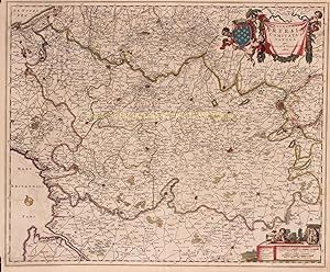
Belgium Foederatum emendate auctum et novissime editum per Nicolaum Visscher
Verlag: Nicolaes Visscher, Amsderdam, 1680
Karte
No Binding. Zustand: Good. Cooper engraving, 46.0 x 55.5 cm on paper 54 x 63.5 cm, with old color in outline (minor spotting and creasing, remnants of the centerfold, and a slight offset of color). A good copy of a map of the Dutch Republic (officially the Republic of the Seven United Netherlands) by Dutch cartographer and publisher Nicolaes Visscher (1618-1709). Koeman III, Vis 5-8.
-

Plan de la ville et citadelle de Lille; Afbeeldinge van de stercke stad Ryssel
Verlag: Nicolaas Visscher, Amsterdam, 1708
Anbieter: Argosy Book Store, ABAA, ILAB, New York, NY, USA
Bewertung:
unbound. Map. Uncolored engraving. Image measures 19.25" x 21". Sheet measures 20.5" x 24.25". This detailed map of Lille or Rijsel shows the city in northern France and its surroundings in exquisite detail. The citadel and fortified city, including streets and buildings noted. Surrounding farmlands are shown with beautifully rendered windmills and houses along with mountains and forests. Depicts the city during the War of the Spanish Succession when the city was occupied by the Dutch. The map is in very good condition with no chips or tears and minor staining near top centerfold. Nicolaes Visscher II, was a Dutch cartographer, publisher and engraver active from the late 17th century to the early 18th century. This is a nice example of his work.