Gesamtpreis (1 Artikel Artikel):
Versandziel:

quad matthias 1557 1613 (11 Ergebnisse)
Direkt zu den wichtigsten Suchergebnissen
Suchfilter
Produktart
- Alle Product Types
- Bücher (7)
- Magazine & Zeitschriften (Keine weiteren Ergebnisse entsprechen dieser Verfeinerung)
- Comics (Keine weiteren Ergebnisse entsprechen dieser Verfeinerung)
- Noten (Keine weiteren Ergebnisse entsprechen dieser Verfeinerung)
- Kunst, Grafik & Poster (Keine weiteren Ergebnisse entsprechen dieser Verfeinerung)
- Fotografien (Keine weiteren Ergebnisse entsprechen dieser Verfeinerung)
- Karten (4)
- Manuskripte & Papierantiquitäten (Keine weiteren Ergebnisse entsprechen dieser Verfeinerung)
Zustand Mehr dazu
- Neu (Keine weiteren Ergebnisse entsprechen dieser Verfeinerung)
- Wie Neu, Sehr Gut oder Gut Bis Sehr Gut (1)
- Gut oder Befriedigend (8)
- Ausreichend oder Schlecht (Keine weiteren Ergebnisse entsprechen dieser Verfeinerung)
- Wie beschrieben (2)
Einband
- alle Einbände
- Hardcover (6)
- Softcover (Keine weiteren Ergebnisse entsprechen dieser Verfeinerung)
Weitere Eigenschaften
- Erstausgabe (Keine weiteren Ergebnisse entsprechen dieser Verfeinerung)
- Signiert (Keine weiteren Ergebnisse entsprechen dieser Verfeinerung)
- Schutzumschlag (1)
- Angebotsfoto (9)
- Keine Print-on-Demand Angebote (11)
Sprache (2)
Preis
- Beliebiger Preis
- Weniger als EUR 20 (Keine weiteren Ergebnisse entsprechen dieser Verfeinerung)
- EUR 20 bis EUR 45 (Keine weiteren Ergebnisse entsprechen dieser Verfeinerung)
- Mehr als EUR 45
Gratisversand
Land des Verkäufers
Verkäuferbewertung
-

GEOGRAPHISCH HANDTBUCH - COLOGNE 1600
Verlag: Theatrum Orkbis Terrarrum, Amsterdam, 1969
Sprache: Deutsch
Anbieter: Terra Firma Books, San Diego, CA, USA
Verkäuferbewertung 5 von 5 Sternen

Hardcover. Zustand: Fine. Zustand des Schutzumschlags: Very Good. Facsimile of 1600 original + Introduction/notes (29pp). Includes 82 double-page maps. No name or writing. CLEAN!
-
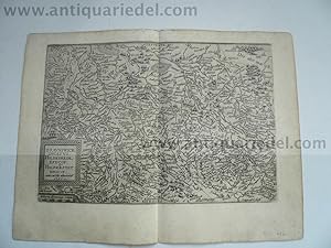
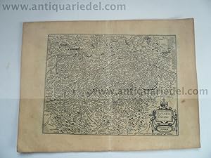
NIEDERSACHSEN & SACHSEN-ANHALT: BRAUNSCHWICK DUCATUS, HILDESHEIM
Verlag: Quad Matthias, 1557-1613, 1613
Anbieter: Hammelburger Antiquariat, Hammelburg, Deutschland
Verkäuferbewertung 5 von 5 Sternen
Hardcover. Zustand: very good. NIEDERSACHSEN & SACHSEN-ANHALT: BRAUNSCHWICK DUCATUS, HILDESHEIM EPISCOP: HALBERSTAT EPISOP: Author: Mathias QUAD (15571613) Place and Year: 1608 Technique: Copper engraving (tiny tears in white margins, slightly age-toned, otherwise in a good condition), sheet: 36 cm x 27,5 cm Highly decorative copper engraved map shows Lower Saxony and Saxony-Anhalt. The map was published in an atlas 'Fasciculus Geographicus' by Matthias Quad (1557 - 1613). Quad was born in the Dutch city of Deventer, where Jacob Roelofs spent his youth. In the 1580 Quad moved to Cologne. The city accepted many political and religious refugees, like Roelofs van Deventer himself some years before. At the same time Frans Hogenberg was active in Cologne too. At the end of the 16th century this city was one of the publishing centres of Europe. Most of the Quad's small format atlases were printed in this time in Cologne. In the time of twelve years he produced 18 geographical-historical books. Because of his controversial religious believes he had to leave Cologne in 1604. After moving around Germany for nine years he died in Eppingen (Baden-Wurttemberg) in 1613. Schöne detaillierte Karte von Niedersachsen und Sachsen-Anhalt mit Hildesheim, Braunschweig und Halberstadt. Aus 'Fasciculus Geographicus'. Gering gebräunt, kleine Risse im Rand, insgesamt gut erhalten. Verso Text.
-
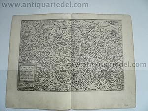
Bayern, anno 1596, Quad/Bussemacher, Karte
Verlag: Quad Matthias, 1557-1613, 1613
Anbieter: Hammelburger Antiquariat, Hammelburg, Deutschland
Verkäuferbewertung 5 von 5 Sternen
Hardcover. Zustand: very good. Bayern, anno 1596, Quad/Bussemacher, Karte BAYERN BAVARIA, GERMANY: BAVARIA DUCATUS. Author: Mathias QUAD (15571613) - Johann BUSSEMACHER (fl. c.1580 1613) Place and Year: Cologne, [1596]. Technique: Kupferstich Copper engraving (Very Good, slightly age-toned), 26,5 x 36 cm (10,4 x 14,2 inches). Detailed map shows Bavaria in Germany. The map was engraved by Johann Bussemacher and published in an atlas 'Fasciculus Geographicus' by Matthias Quad (1557 - 1613). Quad was born in the Dutch city of Deventer, where Jacob Roelofs spent his youth. In the 1580 Quad moved to Cologne. The city accepted many political and religious refugees, like Roelofs van Deventer himself some years before. At the same time Frans Hogenberg was active in Cologne too. At the end of the 16th century this city was one of the publishing centres of Europe. Most of the Quad's small format atlases were printed in this time in Cologne. In the time of twelve years he produced 18 geographical-historical books. Because of his controversial religious believes he had to leave Cologne in 1604. After moving around Germany for nine years he died in Eppingen (Baden-Wurttemberg) in 1613.
-
Wirtenbergensis, anno 1600, Quad
Verlag: Quad Matthias, 1557-1613, 1613
Anbieter: Hammelburger Antiquariat, Hammelburg, Deutschland
Verkäuferbewertung 5 von 5 Sternen
Hardcover. Zustand: very good. "WIRTENBERGENSIS DVCATVS Auctore Georgio Gadnero.", flächenkolorierte Kupferkarte von Quad M., bei Bussemacher, lat. Rückentext, anno 1600. Zeigt das Gebiet zwischen Schwäbisch Hall, Ulm, Bad Herrenalb , Stuttgart im Zentrum der Karte. Blatt: 27x35 cm.
-
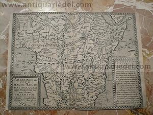
Abyssinorum, map, anno 1600, Bussemacher/Quad, scarce
Verlag: Quad Matthias, 1557-1613, 1613
Anbieter: Hammelburger Antiquariat, Hammelburg, Deutschland
Verkäuferbewertung 5 von 5 Sternen
Hardcover. Zustand: very good. Coppermap, edited Quad/Bussemacher, anno 1600, size: 21x29 cm.
-
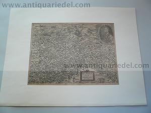
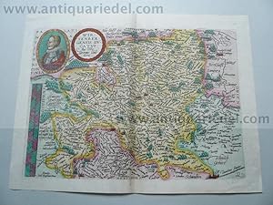
Palatinatus Bavariae/Bussemacher/Quad 1596, Passepartout
Verlag: Quad Matthias, 1557-1613, 1596
Anbieter: Hammelburger Antiquariat, Hammelburg, Deutschland
Verkäuferbewertung 5 von 5 Sternen
Karte
Kein Einband. Zustand: Gut. Kupferkarte von Nordbayern mit einem Portrait von Herzog Wilhelm V, von J. Bussemacher und M. Quad, Köln 1596, hinter Passepartout montiert, Maße: 35x47 und 22x30 cm. Die Karte Wird begrenzt im Nordwesten durch Nürnberg, Erlangen, Forchheim, im Nordosten durch Böhmen und im Süden durch die Donau.
-
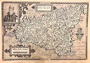
Sicilia
Verlag: Colonia, 1594
Anbieter: Libreria Ex Libris ALAI-ILAB/LILA member, Roma, RM, Italien
Verkäuferbewertung 5 von 5 Sternen
Karte
Carta geografica originale (cm. 30x20,5 piů margini bianchi) tratta dall'opera 'Europae, totius orbis terrarum partis praestantissimae universalis et particularis descriptio' pubblicata in collaborazione con Johann Bussemacher. In alto a sinistra, entro riquadro, il ritratto del Re Filippo II di Spagna. A destra, stemma araldico del Regno di Sicilia. Cinque localitŕ anticamente sottolineate in nero, peraltro esemplare in ottimo stato di conservazione.
-
Typus Orbis Terrarum, Ad Imitationem Universalis Gerhardi Mercatoris
Verlag: Cologne: Johann Bussemachaer, 1596, 1596
Anbieter: Arader Galleries - AraderNYC, New York, NY, USA
Verkäuferbewertung 5 von 5 Sternen
Copperplate Engraving, single sheet, float-mounted and framed (11 1/2 x 14 1/4 inches sheet, 20 x 22 1/2 inches framed). This map is a reduced version of Mercator's planisphere map with a portrait of Jesus Christ and a quotation from Cicero. This map first appeared in the third edition of Quad's travel book, "Europae totius orbis terrarum." South America is misshapen and North America is excessively broad, with the St. Lawrence River long and prominent. In the Far East, Australia is joined to Terra Australis. A prolific member of the "Cologne School of Cartography," Matthias Quad completed his training in Holland before arriving in Germany in 1587. Beginning in 1570, Cologne became a haven for Dutch cartographers eager to seek refuge from religious and political persecution at home. The migration continued for more than forty years resulting in a renaissance of Dutch mapmaking headed by Matthias Quad and Frans Hogenberg. During a period of twelve years lasting from 1592 to 1604, Quad wrote 18 historical and geographical works, which were all published in Cologne, mostly by Johann Bussemacher and Wilhelm Lützenkirchen. A mix of Latin and German, this incredible literary activity a great deal of woodcuts and engravings embellished and improved previous publications. Meurer states, "Quad's work is probably more extensive than is generally recognized." He is known to have published under a number of pseudonyms, including Cyprian Eichovius and Konrad Loew, in order to avoid difficulties resulting from his Reformed faith.
-
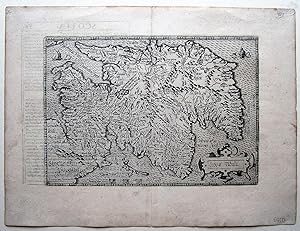
Scotiae Tabula.
Erscheinungsdatum: 1600
Anbieter: Angelika C. J. Friebe Ltd. - MapWoman, Dorking, Vereinigtes Königreich
Verkäuferbewertung 4 von 5 Sternen

Karte
EUR 471,35
EUR 22,88 shipping
Ships from Vereinigtes Königreich to USAAnzahl: 1 verfügbar
In den WarenkorbNo Binding. Zustand: Very Good. copper engraved map; overall 27,5 x 37 cm; plate 19 x 27 cm. fold as issued; edges frayed; paper evenly toned; some off-set; c'folds with small splits not affecting image; some marginal tears not affecting image; o/w vg cond.- A very detailed and early map of Scotland, orientated to the East, by Quad, based on the map by Ortelius; engraved by Johann Bussemacher. The map states early names of places, rivers, mountains etc. With a small cartouche, Latin text on verso. Maps by Quad a rather rare and seldom appear on the market.- Quad was born in Deventer, in the Netherlands; he was a geographer, humanist and engraver who studied in Heidelberg before he settled in Cologne but left to settle in Heidelberg in 1603. He engraved city plans for Braun & Hogenberg's Civitates.
-
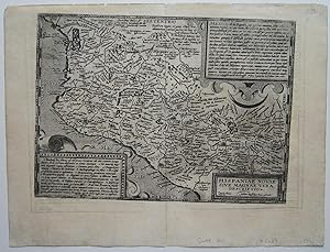
Hispaniae Novae Sive Magnae Vera Descriptio.
Erscheinungsdatum: 1600
Anbieter: Angelika C. J. Friebe Ltd. - MapWoman, Dorking, Vereinigtes Königreich
Verkäuferbewertung 4 von 5 Sternen
Karte
EUR 471,35
EUR 22,88 shipping
Ships from Vereinigtes Königreich to USAAnzahl: 1 verfügbar
In den WarenkorbNo Binding. Zustand: Very Good. Cologne, c1600 copper engraved map; overall 27,5 x 36,5 cm; plate 21 x 29,5 cm. fold as issued; edges frayed; paper evenly toned; some off-set; c'folds with small splits not affecting image; plate slightly rubbed in places; some marginal tears not affecting image; o/w vg cond. A very detailed and early map of Mexico by Quad, based on the map by Ortelius; engraved by Johann Bussemacher. The map states early names of places, rivers, mountains etc. With a small cartouche, a box top right corner with descriptive text about the entire country; a second box, lower left, with numbers referring to places within the map. Latin text on verso. Maps by Quad a rather rare and seldom appear on the market. Quad was born in Deventer, in the Netherlands; he was ageographer, humanist and engraver who studied in Heidelberg before he settled in Cologne but left to settle in Heidelberg in 1603. He engraved city plans for Braun & Hogenberg's Civitates. Ref: 3227.