Gesamtpreis (1 Artikel Artikel):
Versandziel:

ross lieut john (3 Ergebnisse)
Direkt zu den wichtigsten Suchergebnissen
Produktart
- Alle Produktarten
- Bücher (2)
- Magazine & Zeitschriften (1)
- Comics
- Noten
- Kunst, Grafik & Poster
- Fotografien
- Karten
-
Manuskripte &
Papierantiquitäten
Zustand
- Alle
- Neu
- Antiquarisch/Gebraucht
Einband
- alle Einbände
- Hardcover
- Softcover (1)
Weitere Eigenschaften
- Erstausgabe
- Signiert
- Schutzumschlag
- Angebotsfoto (2)
- Kein Print-on-Demand
Land des Verkäufers
Verkäuferbewertung
-
AMAZING Stories: June 1938
Verlag: Ziff-Davis, NY, 1938
Magazin / Zeitschrift
SingleIssueMagazine. Zustand: Good-. Vol. 12, No. 3. First Ziff-Davis issue, and with new editor, Raymond A. Palmer. Cover photo by Horace Hime, Frank Lewis, Inc. Includes "The Man Who Ruled the World" by Robert Moore Williams; "The Escape Through Space" by Ross Rocklynne; "The Master of Golden City" by Polton Cross [John Russell Fearn]; "The Vanishing Diamonds" by Charles R. Tanner; "A Summons from Mars" by John Russell Fearn; "The Space Pirate" by Eando Binder; "The Invisible Bomber" by Lieut. John Pease. Features: "Meet the Authors"; "The Observatory"; "Ammazing Facts of Science"; "Mathematical Puzzles"; "this Amazing Universe"; "Discussions"; "Science Quiz"; "Questions & Answers"; "Correspondence Corner". Illustrated by Jay Jackson, J. C. Sewell, Harold Welch, and H. W. McCauley. Stains to front cover with only slight offset to first page; rear cover was wet with milder stains and even less offset to last page; tears to rear cover; creasing; some roll; standard wear and tear at edges; mild tanning.
-
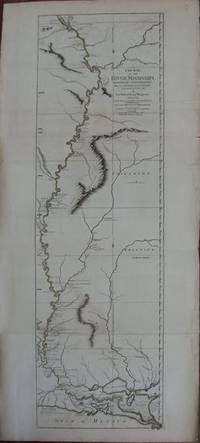
Course of the River Mississippi from the Balise to Fort Chatres taken on an Expedition to the Illinois in the latter end of the year, 1765.
Verlag: Robert Sayer, London, 1775
Anbieter: William Chrisant & Sons, ABAA, ILAB. IOBA, ABA, Ephemera Society, Fort Lauderdale, FL, USA
Verbandsmitglied: ABAA ESA ILAB
Bewertung:

Map. Zustand: Very Good. Original hand-coloring in outline. The most detailed map of the Mississippi published in the 18th century. Prime meridian: New Orleans and Ferro. Shows historic points of interest, indigenous villages, evidence of German settlements, quarries, mines, boundaries, fertile land, cane fields, French Forts, etc. Relief shown pictorially. Soundings in Gulf of Mexico and Depths of the Mississippi. Goss, Mapping of North America, 67 ; Folio; All shipments through boxed USPS insured Priority Mail.
-

Course of the River Mississippi, from the Balise to Fort Charles; Taken on an Expedition to the Illinois, in the Latter End of the Year.
Verlag: London: Sayer & Bassett, June 1775 (1776)., 1776
2 sheets join to single sheet (46 x 21 ˝ inches) Fine engraved map of the Mississippi "from the Balise to Fort Chartres; taken on an expedition to the Illinois, in the latter end of the year 1765. By Lieut. (John) Ross of the 34th Regiment: Improved from the surveys of the river made by the French", the title upper right, showing forts, Native American villages, quarries, mines, boundaries, fertile land, cane fields, soundings in the Gulf of Mexico, with descriptive notes and a note on "Depths of the Mississipi", with original hand-colour in outline. Ross' large scale map of the Mississippi River is one of the few large forma maps of the River published during the 18th century. This was the first official English survey of the Lower Mississippi, significantly delineating the British gains from France in the French-Indian War. It later established the future Western boundary of the New United States. The map opened the area to settlement from the East and defined the Western limits of he American colonies. This is the most detailed survey of the Mississippi River from the period of the American Revolution, depicting an economically and strategically important area of French America at the beginning of the war. The vast sweep of the river had provided the French with a tremendous trade route along which a highly lucrative fur trade had evolved. Lieutenant John Ross, surveyor of the 34th Regiment of the British Army, set out in 1765 to map this increasingly important region on behalf of the British government. His expedition mapped the river's course from the tip of the Mississippi Delta to "Fort Chartres," about 75 miles south of St. Louis Ross's map provides a fascinating insight into the knowledge and settlement of the river during this early period. He depicts the river's course in excellent detail, providing fort and village names, as well as well as information on local Indian populations and regional history. In the delta region, there is navigational information for ships approaching the river's entrance, and as the river winds its way north, Ross shows evidence of German settlements, abandoned French forts and informative topographical detail. He notes the point where Spanish explorer Ferdinand de Soto first discovered the Mississippi in 1541, and to the west of the river he marks the locations of Native American tribes and villages. Ross's work is a landmark in the cartography of the Mississippi River, and an engaging document of American colonial history. Published in Thomas Jeffrey's celebrated "The American Atlas" by Sayer and Bennett in 1775. Arguably the most important 18th-century atlas of America, depicting North America as Revolutionary War raged between the United States and England, and described by Walter Ristow as a "geographical description of the whole continent of America, as portrayed in the best available maps in the latter half of the eighteenth century. as a major cartographic reference work it was, very likely, consulted by American, English, and French civilian administrators and military officers during the Revolution." Jefferys died in November 1771 and his successors, Robert Sayer and John Bennett, gathered together these separately published maps to form The American Atlas. For more information about this map, or a warm welcome to see it and other maps in our library at 72nd Street, NYC, please contact Natalie Zadrozna.