
Gesamtpreis (1 Artikel Artikel):
Versandziel:

willem johannes blaeu (24 Ergebnisse)
Direkt zu den wichtigsten Suchergebnissen
Produktart
- Alle Produktarten
- Bücher (5)
- Magazine & Zeitschriften
- Comics
- Noten
- Kunst, Grafik & Poster (1)
- Fotografien
- Karten (18)
-
Manuskripte &
Papierantiquitäten
Zustand
- Alle
- Neu
- Antiquarisch/Gebraucht
Einband
Weitere Eigenschaften
- Erstausgabe (1)
- Signiert
- Schutzumschlag
- Angebotsfoto
- Kein Print-on-Demand
Gratisversand
Land des Verkäufers
Verkäuferbewertung
-
![Bild des Verkäufers für Namur / Namür / Hennegau. - Historische Kupferstichkarte. Comitatuum Hannoniae et Namurci descriptio. [Grafschaft Hennegau, frz: Hainaut in Belgien nebst angrenzender Gebiete. Wahrscheinlich aus: van der Krogt, Koeman's Atlantes Neerlandici, Vol. I.] zum Verkauf von Antiquariat Carl Wegner](https://pictures.abebooks.com/inventory/md/md14339280276.jpg)
Namur / Namür / Hennegau. - Historische Kupferstichkarte. Comitatuum Hannoniae et Namurci descriptio. [Grafschaft Hennegau, frz: Hainaut in Belgien nebst angrenzender Gebiete. Wahrscheinlich aus: van der Krogt, Koeman's Atlantes Neerlandici, Vol. I.]
Verlag: [Johannes Janssonius (Jansson). Amsterdam, 1636.], 1636
Erstausgabe
Softcover. Kartengröße: 49 x 51,5 cm. Oben links einEngel die Meilenanzeige haltend, unten rechts die Titelkartusche von zwei Wappen flankiert: rechts vier Löwen unter einer Krone (das Wappen von Hennegau), rechts ein Löwe unter einer Krone (das Wappen Belgiens). Im unteren Randbereich ein 2 cm langer Einriss, der bis in die Karte hineinreicht, sonst im Randbereich kleinere Fehlstellen und Einrisse. Der Kartenbereich im unteren rechten Eck nur in der Randung mit Längen- und Breitengraden etwas abgerieben. Weiterhin auf der Karte: Wallonien, Mons, Teile von Brabant begrenzt durch Oudenaarde, Huy und Cambrai, oben links Flandern. - Versand als Rolle zu 5.-Euro. --- Bitte Portokosten außerhalb EU erfragen! / Please ask for postage costs outside EU! / S ' il vous plait demander des frais de port en dehors de l ' UE! -- Herzlichen Dank für Ihre Bestellung! Fe2Klavier.
-
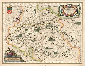
Ducatus Turonensis Gorgeous 17th century map of the traditional French province of Touraine.
Erscheinungsdatum: 1635
Anbieter: Curtis Wright Maps, Berwyn, IL, USA
Bewertung:

Zustand: Fine. This attractive hand colored map shows the traditional French province of Touraine, in the center of the country. The Loire River can be seen horizontally bisecting the image, with the provincial capital of Tours found on its bank. The coat of arms of the city is shown in the upper left. The region's abundant agriculture and viticulture is referenced in the decorative cartouches found in the upper right and lower left corners. It's likely that several of the abbeys and wineries shown on the map are still producing today. Published in 1635 by Willem and Johannes Blaeu. Sheet Width (in) 20.5 Sheet Height (in) 16 Condition Description One small damp stain in the left margin that just touches the neatline and faint wear along the centerfold. Features lovely hand color.
-
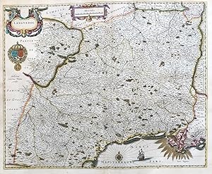
Cadurcium Vernaculé Querci" - Quercy Cahors Occitanie Lot Montauban Souillac France Frankreich carte
Verlag: Amsterdam ca. 1640., 1640
Anbieter: Antiquariat Steffen Völkel GmbH, Seubersdorf, Deutschland
Bewertung:

Karte
Große altkolorierte Kupferstich-Karte von ca. 1640. -- Mit lateinischem Text auf der Rückseite. -- Blatt-Maße: ca. 50 x 59 cm. -- gut erhalten. || Large old colored map from ca. 1640. With Latin text on verso. -- in good condition. || Dies ist ein Original! - Kein Nachdruck! - Keine Kopie! -- This is an original! - No copy! - No reprint! la.
-
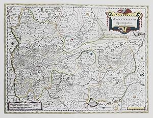
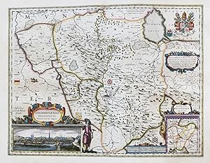
Monasteriensis Episcopatus" - Bistum Münster Bad Bentheim Osnabrück Rheine Quakenbrück Meppen Nordrhein-Westfalen map Karte
Verlag: Amsterdam, 1649
Anbieter: Antiquariat Steffen Völkel GmbH, Seubersdorf, Deutschland
Bewertung:
Karte
Blatt-Masse ca. 48,5 x 59 cm - Platte ca. 38 x 50,5 cm - Original handkolorierte Kupferstich-Karte von 1649. Rückseitig mit deutschem Text. - Aus Blaeu's "Novus Atlas, Das ist Weltbeschreibung mit schönen newen außführlichen Land-Taffeln in Kupffer gestochen und an den tag gegeben". - gut erhalten -- Rare hand-coloured engraved map from the German edition of Blaeus Novus Atlas from 1649. With German text on verso. -- in good condition.|| Dies ist ein Original! - Kein Nachdruck! - Keine Kopie! -- This is an original! - No copy! - No reprint! Sprache: Deutsch Gewicht in Gramm: 1500.
-
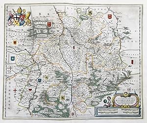
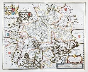
Episcopatus Hildesiensis Descriptio Novissima" - Bistum Hildesheim Einbeck Hameln Goslar Wolfenbüttel Niedersachsen map Karte
Verlag: Amsterdam, 1649
Anbieter: Antiquariat Steffen Völkel GmbH, Seubersdorf, Deutschland
Bewertung:
Karte
Blatt-Masse ca. 48,5 x 59 cm - Platte ca. 38 x 50,5 cm - Original handkolorierte Kupferstich-Karte von 1649. Rückseitig mit deutschem Text. - Aus Blaeu's "Novus Atlas, Das ist Weltbeschreibung mit schönen newen außführlichen Land-Taffeln in Kupffer gestochen und an den tag gegeben". - gut erhalten -- Rare hand-coloured engraved map from the German edition of Blaeus Novus Atlas from 1649. With German text on verso. -- in good condition. || Dies ist ein Original! - Kein Nachdruck! - Keine Kopie! -- This is an original! - No copy! - No reprint! Sprache: Deutsch Gewicht in Gramm: 1500.
-
Episcopatus Hildesiensis Descriptio Novissima" - Bistum Hildesheim Einbeck Hameln Goslar Wolfenbüttel Niedersachsen
Verlag: Amsterdam ca. 1640., 1640
Anbieter: Antiquariat Steffen Völkel GmbH, Seubersdorf, Deutschland
Bewertung:
Karte
Große altkolorierte Kupferstich-Karte von ca. 1640. -- Mit lateinischem Text auf der Rückseite. -- Blatt-Maße: ca. 49,5 x 59 cm. -- gut erhalten. || Large old colored map from c. 1640. With Latin text on verso. -- in good condition. || Dies ist ein Original! - Kein Nachdruck! - Keine Kopie! -- This is an original! - No copy! - No reprint! la.
-
Carte de 1612 représentant le Nord, Pas-de-Calais, Artois. Gravée par « Ihoannes a Doetechum iunior fecit » pour Lodovico Guicciardini pour l'ouvrage publié par Willem Blaeu ŕ Amsterdam « Beschryvinghe van alle de andersins neder-landen ghenoemt neder-duytslandt ». De format (cuvette) 32 par 23,5 cm. Bel exemplaire bien frais, grand de marge, verso sans inscriptions.
-
Osnaburgensis Episcopatus" - Bistum Osnabrück Niedersachsen map Karte
Verlag: Amsterdam, 1649
Anbieter: Antiquariat Steffen Völkel GmbH, Seubersdorf, Deutschland
Bewertung:
Karte
Blatt-Masse ca. 48,5 x 59 cm - Platte ca. 38 x 50,5 cm - Original handkolorierte Kupferstich-Karte von 1649. Rückseitig mit deutschem Text. - Aus Blaeu's "Novus Atlas, Das ist Weltbeschreibung mit schönen newen außführlichen Land-Taffeln in Kupffer gestochen und an den tag gegeben". - gut erhalten -- Rare hand-coloured engraved map from the German edition of Blaeus Novus Atlas from 1649. With German text on verso. -- in good condition.|| Dies ist ein Original! - Kein Nachdruck! - Keine Kopie! -- This is an original! - No copy! - No reprint! Sprache: Deutsch Gewicht in Gramm: 1500.
-
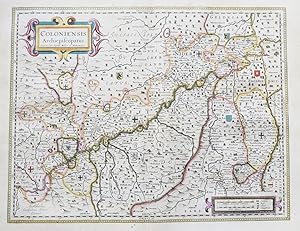
Coloniensis Archiepiscopatus" - Erzbistum Köln Bonn Duisburg Dortmund Düsseldorf Wuppertal Leverkusen Mönchengladbach Nordrhein-Westfalen
Verlag: Amsterdam ca. 1640., 1640
Anbieter: Antiquariat Steffen Völkel GmbH, Seubersdorf, Deutschland
Bewertung:
Karte
Große altkolorierte Kupferstich-Karte von ca. 1640. -- Mit lateinischem Text auf der Rückseite. -- Blatt-Maße: ca. 49,5 x 59 cm. -- gut erhalten. || Large old colored map from c. 1640. With Latin text on verso. -- in good condition. || Dies ist ein Original! - Kein Nachdruck! - Keine Kopie! -- This is an original! - No copy! - No reprint! la.
-
Osnabrugensis Episcopatus" - Osnabrück Bad Essen Lingen Ibbenbüren Melle Bramsche Lengerich Dümmer Niedersachsen
Verlag: Amsterdam ca. 1640., 1640
Anbieter: Antiquariat Steffen Völkel GmbH, Seubersdorf, Deutschland
Bewertung:
Karte
Große altkolorierte Kupferstich-Karte von ca. 1640. -- Mit lateinischem Text auf der Rückseite. -- Blatt-Maße: ca. 49,5 x 59 cm. -- gut erhalten. || Large old colored map from c. 1640. With Latin text on verso. -- in good condition. || Dies ist ein Original! - Kein Nachdruck! - Keine Kopie! -- This is an original! - No copy! - No reprint! la.
-
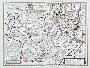
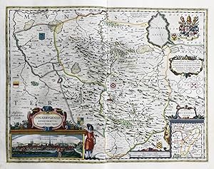
Paderbornensis Episcopatus Descriptio Nova" - Erzbistum Paderborn Bielefeld Lippstadt Gütersloh Bad Lippsringe Warburg Höxter Büren Salzkotten Driburg Nordrhein-Westfalen
Verlag: Amsterdam ca. 1640., 1640
Anbieter: Antiquariat Steffen Völkel GmbH, Seubersdorf, Deutschland
Bewertung:
Karte
Große altkolorierte Kupferstich-Karte von ca. 1640. -- Mit lateinischem Text auf der Rückseite. -- Blatt-Maße: ca. 49,5 x 59 cm. -- gut erhalten. || Large old colored map from c. 1640. With Latin text on verso. -- in good condition. || Dies ist ein Original! - Kein Nachdruck! - Keine Kopie! -- This is an original! - No copy! - No reprint! la.
-
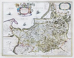
Prussia Accurate Descripta" - Polska Polen Poland Ostpreußen Prussia map Karte
Verlag: Amsterdam ca. 1640., 1640
Anbieter: Antiquariat Steffen Völkel GmbH, Seubersdorf, Deutschland
Bewertung:
Karte
Große altkolorierte Kupferstich-Karte von ca. 1640. -- Mit lateinischem Text auf der Rückseite. -- Blatt-Maße: ca. 49,5 x 59 cm. -- mit 2 winzigen Wurmspuren im Bereich des Meeres (ohne Bildverlust), sonst gut erhalten. || Large old colored map from c. 1640. With Latin text on verso. -- with two minor worm holes in the region of the sea (with no loss of image), otherwise in good condition. || Dies ist ein Original! - Kein Nachdruck! - Keine Kopie! -- This is an original! - No copy! - No reprint! la.
-
Zustand: ottima. Bella incisione in rame con coloritura coeva sui confini, ampi margini ed in ottimo stato di conservazione, raffigurante il territorio di Parma e Piacenza con cartiglio decorativo in basso a sinistra. Tratta da ěAtlas Novusî di Blaeu. This map of Parma and Piacenza was published in 1640 by Joan Blaeu (1598-1673) in the third volume of his Atlas Novus. Formato: 380x500mm.
-
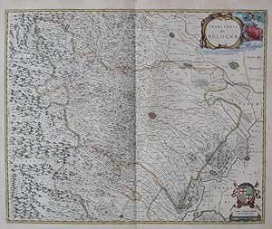
Zustand: perfetta. Incisione in rame, con bella coloritura coeva e testo in francese al verso. Piacevole cartiglio in alto a destra e lo stemma di Bologna in basso. Perfetto stato di conservazione. Formato: 440x550mm.
-

Zustand: buona. Bella incisione a coloritura d'epoca, raffigurante lo ěStato di Milanoî di Blaeu, tratta dall'atlante di Abraham Wolfgang. Mappa dettagliata dell'area circostante Milano e le altre provincie del Nord Italia, includendo il Lago di Garda ed il Lago Maggiore. La carta riporta numerose cittŕ e castelli evidenziati dal colore rosso: Como (con il Lago di Como), Vercelli, Torino, Bergamo, Piacenza, Parma ed altre. Esemplare in ottimo stato di conservazione con margini. Sono tuttavia presenti delle macchioline nella parte destra in basso del foglio. Nice old color example of Blaeu's map of the "State of Milan," from a composite atlas by Abraham Wolfgang. Detailed map of the area surrounding Milan, the capital of the region of Lombardy and the other provinces within northern Italy. This map illustrates as far east as Lake Garda and westward past Lake Maggiore to the Swiss border. Included are numerous city centers and castles, each highlighted with red coloring: Como (also noting Lake Como), Vercelli, Turin, Bergamo, Piacenza, Parma and more. Formato: 415x525mm.
-
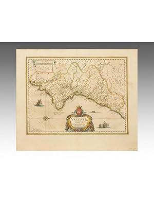
WILLEM JANSZOON BLAEU VALENTIA REGNUM. CONTESTANI. PTOL. EDENTANI, PLIN.
Erscheinungsdatum: 1640
Anbieter: L'Art de la Memňria, Sant Andreu de Llavaneres, BARCE, Spanien
Bewertung:

Buch
Sin Encuadernar. Zustand: Excelente. Atractively hand-colored example of Blaeu's map, centered on Valencia and extending south to Murcia and Orihuela. Includes decorative compass rose, three sailing ships, sea monster and ornate cartouche with the arms of Valencia. Materia: Mapa antiguo del siglo XVII. Valencia. Espańa Publicación: Amsterdam, cerca 1638. Descripción: Decorativo mapa del Siglo XVII del Reino de Valencia. Bellas cartelas barrocas para título y escala de millas. Escudo de Valencia centrado sobre la cartela. Versión con texto en alemán. Color de época. Medidas: 390 x 500 mm. huella / 500 x 590 mm papel. Técnica: Grabado calcográfico. Color de época. Conservación: Muy buen estado. papel limpio y de gran calidad. Todos los márgenes. Pequeńa mancha de 1 cm. en orla. Willem Janszoon Blaeu (1571, Uitgeest or Alkmaar 21 de octubre, 1638, Ámsterdam), cartógrafo y editor de atlas holandés. Tuvo dos hijos, Joan Blaeu y Cornelius Blaeu, que continuaron el negocio de su padre relativo a la edición y publicación de mapas después de la muerte de éste en 1638.
-
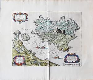
Zustand: ottimo. Incisione in rame. Fascinosissima carta dell'isola di Ischia tratta dall'Atlante Maior pubblicato ad Amsterdam nel 1667. Grandi cartigli e bellissima calligrafia, in questo esemplare colorato.Ottimo stato di conservazione. Formato: 380x500mm.
-
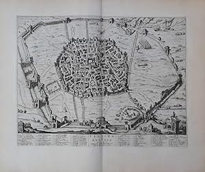
Zustand: perfetta. Incisione in rame. Scenografica carta di Bologna antica, con le mura. In basso al centro č riportata la scritta Felsina Sive Bononia Antiqua. A sinistra ed a destra vi sono 73 rimandi di riferimento, riportati nella veduta. Perfetto stato di conservazione. Formato: 359x505mm.
-
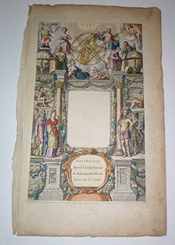
Title page for THEATRUM ORBIS TERRARUM, Sive ATLAS NOVUS; in quo TABULAE et Descriptiones omnium Regionum, Editae a Guiljel: et Joanne Blaeu. First edition.
Verlag: Amsterdam: Willem Blaeu & Johannes Blaeu 1635, 1635
Kunst / Grafik / Poster
Zustand: Good. Folio. 49.8 x 29.7 cm. Old laid paper with arrow above H watermark. Possibly contemporary coloring. Remainder of paper binding hinge. Willem Blaeu (1571-1638) et Johannes Blaeu (1596-1673)BELLE PAGE DE TITRE D'ATLAS sans texte, gravée en noir rehaussée d'aquarelle, avec partie de texte en latin dans le médaillon inférieur, Amsterdam, 1635.(restauration en bordure)50 x 30,5 cmExpertise by Jean-François BétisF-40360 Donzacq.
-
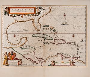
Insulae Americanae in Oceano Septentrionali cum Terris Adiacentibus.
Verlag: Amsterdam n.d. c., 1650
Anbieter: Shapero Rare Books, London, Vereinigtes Königreich
Verbandsmitglied: ABA ILAB PBFA
Bewertung:
Karte
Hand-coloured double-page engraved map, centre fold as issued, cartouches for the title and scale, Latin text on verso; sheet size: 49 x 56.7 cm. A beautiful map of the West Indies showing the eastern coast of North America from Chesapeake Bay to the Gulf of Mexico, Central America and the northern coast of South America.
-
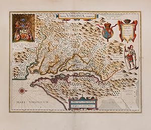
Nova Virginiae Tabula.
Verlag: Amsterdam n.d. c, 1650
Anbieter: Shapero Rare Books, London, Vereinigtes Königreich
Verbandsmitglied: ABA ILAB PBFA
Bewertung:
Karte
Hand-coloured double-page engraved map, centre fold as issued, cartouches for the title and scale, Latin text on verso; sheet size: 49 x 56 cm. This appealing and richly decorated map shows the discoveries of this region Virginia, the Chesapeake Bay and Maryland after John Smith's map of 1612.
-
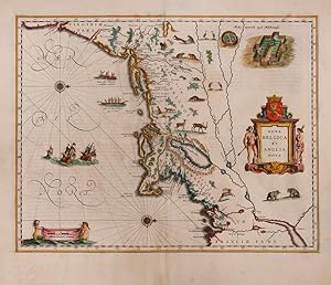
Nova Belgica et Anglia Nova.
Verlag: Amsterdam n.d. c, 1650
Anbieter: Shapero Rare Books, London, Vereinigtes Königreich
Verbandsmitglied: ABA ILAB PBFA
Bewertung:
Karte
Hand-coloured double-page engraved map, centre fold as issued, with cartouches for the title and scale, Latin text on verso; sheet size: 49 x 56 cm. Engraved map of the east cost of North America unusually oriented to the south, showing the area from Chesapeake Bay in Virginia to Penscabot Bay in New France, the title and scale within fine allegorical cartouches, decorated with images of Native American villages, Native Americans in their canoes, European ships, wild animals, lakes and forests. It is one of the earliest maps to name New York ('Nieu Amsterdam').
-
[Atlas of Italy] Guil. et Joannis Blaeu Theatrum Orbis Terrarum, sive Atlas Novus. Pars Tertia
Erscheinungsdatum: 1645
Anbieter: Maggs Bros. Ltd ABA, ILAB, PBFA, BA, London, Vereinigtes Königreich
Verbandsmitglied: ABA ILAB PBFA
Bewertung:
Large Folio (500 x 336 mm); engraved title-page with letter-press paste-over; sixtytwo engraved maps, all but one double-page, comprising fifty-eight of Italy and its regions, and four of Greece and regions, including Crete. 18th century mottled calf, seven raised bands, gilt floral tooling and gilt lettering to spine. Both joints split (binding still holding), boards and spine worn, tooling and lettering faded. Amsterdam : Johannes Blaeu, The Blaeu family were the pre-eminent Dutch atlas-publishers of their period. The family published their first terrestrial atlas in 1630, with the multi-volume Atlas Novus launched in 1635. They continued to enlarge the atlas over the next thirty-five years, adding new maps to expand sections, but also preparing separate volumes devoted to England and Wales, Scotland and China. This is the third volume of the Atlas Novus, devoted to Italy, the coverage of that county expanded to almost fill an entire volume, with a small section at the end of Greece. Although not technically an atlas of Italy, the suite of maps relating to Italy and its provinces represents the next geographic advance on Giovanni Antonio Magini?s atlas Italia ., the first separate printed atlas of Italy, first published in 1620 and reissued in 1632. The maps are accompanied by a descriptive geographical text in Latin. Reference: Koeman, BL 37A; the index calls for a section with maps of Scotland and Ireland but this is not, and never was, present, as usual when this volume was issued in the set with the England volume, where the maps were placed.
-
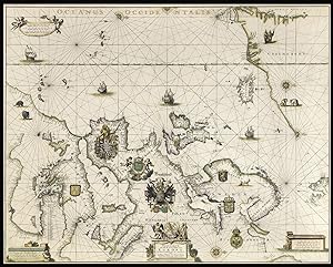
Pascaarte van alle de Zee-custen van Europa tot Amsterdam MDCLXXVII, Amsterdam, 1677.
Verlag: Amsterdam,, 1677
Anbieter: Daniel Crouch Rare Books Ltd, London, Vereinigtes Königreich
Verbandsmitglied: ABA ILAB PBFA
Bewertung:

Karte
A majestic sea chart from the Dutch "Golden Age" probably illuminated by the "Meester Afsetter" Dirk Jansz van Santen Separately published large engraved chart, printed in two sheets on thick paper, joined, with fine contemporary hand-colour lavishly heightened in gold. One of the last maps to bear the Blaeu family imprint and a tour-de-force of the mapmaker's art. An exceptional rarity, and a splendid work of art, the Pascaarte of Europe was the work of the grandsons of Willem Jansz. Blaeu, Pieter and Johannes, and one of the last maps to bear the Blaeu imprint as the chart dates from the period following the fire at the Blaeu family's Gravenstraat premises in Amsterdam in February 1672. A year later Johannes Blaeu I died, and the remaining plate stock was auctioned in 1674 and 1677. The present chart of Europe therefore is one of the few productions from the post-fire period. The chart is an improved re-engraving of the elder Blaeu's 1621 (or later) chart with the same title. No census of the 1677 chart has ever been attempted, but Schilder locates only two examples of the c.1621 pascaarte printed on paper, compared to six on vellum. This is the last in a series of large-scale pascaartes of Europe published from c.1606 by the firm of Blaeu. The charts of 1621 and 1677 extend much further west than the earlier examples, so that they include southern Greenland and the Azores. They also add small compass roses that Cannenberg says "show the magnetic variation on the spot." The 1677 chart improves on the 1621 by extending the coast of Greenland, and correcting the coasts of Iceland, Ireland and other parts of Europe. Illumination One of the greatest treasures from the Golden Age of Dutch cartography is the 19-volume 'Atlas van Hadrianus Relandus' at the Meermanno-Westreenianum Museum in The Hague. Not only does it include many legendary maps and sea charts of the seventeenth century, but, according to Herman de la Fontaine Vervey, "the majestic whole has been coloured leaf by leaf by van Santen with the utmost care, using transparent colours, and with even the tiniest details heightened with gold." He was referring to Dirk Jansz van Santen, the "Meester Afsetter" (master colourist), whose "name was renowned throughout his lifetime and long thereafter, and for whose work there was great demand." Dirk Jansz. van Santen "illuminated and gilded the most prestigious printed works of his time in an exceptionally painterly and brilliant manner. In so doing, he made the Golden Age, quite literally, golden" (Goedings). His clients were the foremost collectors of his age, who often described his art in similarly eulogistic terms. Rarely do maps coloured in van Santen's hand come up for sale; rarer still are maps offered that can be ascribed to him with certainty, as he did not sign the works that he illuminated. The present example can confidently be attributed to the master,as it is coloured in a manner identical to that used for the chart of Southeast Asia by Hendrick Doncker in the Hadrianus Relandus atlas. A note in the Relandus atlas reads "artifex eximinus Theodorus van Santen," and when the atlas came up for sale in 1707, the catalog stated that it was "magnificently coloured by Dirk Jansz van Santen, the equal of Blok." This comparison to Joanna Blok-Koerten was a strong accolade, as she was the seventeenth century Dutch artist most celebrated for fine colouring. Examples from the Relandus atlas of two of the three maps here offered are illustrated in Robert Putnam's 'Early Sea Charts'. Both have pale blue oceans, rich colouring in the decorative vignettes, and the lavish use of gold. The colouring is so alike on the two charts that at first we were concerned that they might be the same work, but close inspection revealed such minor differences as the outline color of Japan on ours it is green; on the Relandus copy it is red - that make it clear that they are in fact different charts coloured by the same hand. Truusje Goedings, author of 'Dirk Jansz. Van Santen a Survey', and acknowledged authority on the works of the master colourist, has examined the present charts and compared them carefully with the maps in the Relandus atlas, and has made the following statement: : "I have examined the two charts at Daniel Crouch Rare Books, and the equivalent charts in the 'Atlas van Hadrianus Relandus' at the Meermanno-Westreenianum Museum in The Hague, and I can confidently conclude that these charts were coloured by the same hand". A copy of her full report on the charts is available on request. Burden, P, 'The Mapping of North America', I, #233 (state II/III); Campbell, T, ' Blaeu's second 'West Indische paskaart' of 1630,' in 'The Map Collector', 30, pp. 36-38; Cannenberg, W. V., 'A Dutch Chart that Survived the Ages', in 'Imago Mundi', IV, pp. 62-63; Fontaine Verwey, Herman de la, 'The Glory of the Blaeu Atlas and the Master Colourist', in Quaerendo XI (1981), pp. 197-229; Keuning &c., 'Willem Janzoon Blaeu', plate 10, & pp. 74-75; Putnam, R., 'Early Sea Charts', plates 27, 41; Schilder, G., 'Monumenta Cartographica Neerlandica', IV, pp.100, 45.1 (first edition, dating 1621 or later) and 114-117, plate 2.53; Schilder, G., 'Willem Janszoon Blaeu's Map of Europe (1606), A Recent Discovery in England', in 'Imago Mundi', 28 (1976), pp. 9-20; Waters, D., 'The Art of Navigation', plate LXXVIII; & p. 327; Zandvliet, K., 'Mapping for Money', plate 9.4, & p. 168-169. See also Keuning, 'Hessel Gerritsz', 'Imago Mundi', VI, 49-66; Goedings, T., 'A Composite Atlas Coloured by Dirk Jansz. Van Santen', pp. 24, 25 (no. 3), 32.
![Bild des Verkäufers für [Atlas of Italy] Guil. et Joannis Blaeu Theatrum Orbis Terrarum, sive Atlas Novus. Pars Tertia zum Verkauf von Maggs Bros. Ltd ABA, ILAB, PBFA, BA](https://pictures.abebooks.com/inventory/md/md30447192978.jpg)