
Gesamtpreis (1 Artikel Artikel):
Versandziel:

9780721709383 - Map of UK and Ireland - Laminated (53 x 77cm) von Schofield & Sims (15 Ergebnisse)
Direkt zu den wichtigsten Suchergebnissen
Produktart
- Alle Produktarten
- Bücher (14)
- Magazine & Zeitschriften
- Comics
- Noten
- Kunst, Grafik & Poster
- Fotografien
- Karten (1)
-
Manuskripte &
Papierantiquitäten
Zustand
Einband
- alle Einbände
- Hardcover
- Softcover (2)
Weitere Eigenschaften
- Erstausgabe
- Signiert
- Schutzumschlag
- Angebotsfoto (9)
- Kein Print-on-Demand
Land des Verkäufers
Verkäuferbewertung
-

Map of Uk and Ireland
Verlag: Schofield & Sims Ltd, 2012
ISBN 10: 0721709389ISBN 13: 9780721709383
Buch
Zustand: As New. Unread book in perfect condition.
-

Map of Uk and Ireland
Verlag: Schofield & Sims Ltd, 2012
ISBN 10: 0721709389ISBN 13: 9780721709383
Buch
Zustand: New.
-

Map of UK and Ireland
Verlag: Schofield & Sims Ltd, West Yorkshire, 2002
ISBN 10: 0721709389ISBN 13: 9780721709383
Buch
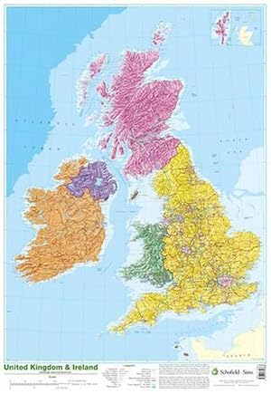
Zustand: new. This detailed relief map of the United Kingdom and Ireland is colour coded to show the area of each country and large city. County boundaries are marked, as are rivers, motorways, ports and airports. An explanation of the political relationship between the countries is given, alongside information about the distance from sea level to Ben Nevis. This detailed relief map of the United Kingdom and Ireland is colour coded to show the area of each country and large city. Shipping may be from multiple locations in the US or from the UK, depending on stock availability.
-

Map of UK and Ireland
Verlag: Schofield and Sims Ltd, 2002
ISBN 10: 0721709389ISBN 13: 9780721709383
Buch
UNK. Zustand: New. New Book. Shipped from UK. Established seller since 2000.
-
Map of UK and Ireland
Verlag: Schofield & Sims Ltd, 2002
ISBN 10: 0721709389ISBN 13: 9780721709383
Buch
Paperback. Zustand: New. BRAND NEW ** SUPER FAST SHIPPING FROM UK WAREHOUSE ** 30 DAY MONEY BACK GUARANTEE.
-
Map of UK and Ireland
Verlag: Schofield & Sims Ltd, 2012
ISBN 10: 0721709389ISBN 13: 9780721709383
Anbieter: Ria Christie Collections, Uxbridge, Vereinigtes Königreich
Bewertung:

Buch
Zustand: New. In.
-
Map Of Uk And Ireland
Verlag: Schofield & Sims Ltd, 2002
ISBN 10: 0721709389ISBN 13: 9780721709383
Karte
Map. Zustand: Brand New. 1 pages. 42.99x2.56x2.44 inches. In Stock.
-
Map of UK and Ireland
Verlag: Schofield & Sims Ltd, 2012
ISBN 10: 0721709389ISBN 13: 9780721709383
Buch
Zustand: new.
-
Map of Uk and Ireland
Verlag: Schofield & Sims Ltd, 2012
ISBN 10: 0721709389ISBN 13: 9780721709383
Anbieter: GreatBookPricesUK, Castle Donington, DERBY, Vereinigtes Königreich
Bewertung:

Buch
Zustand: New.
-
Map of Uk and Ireland
Verlag: Schofield & Sims Ltd, 2012
ISBN 10: 0721709389ISBN 13: 9780721709383
Anbieter: GreatBookPricesUK, Castle Donington, DERBY, Vereinigtes Königreich
Bewertung:
Buch
Zustand: As New. Unread book in perfect condition.
-
Map of UK and Ireland
Verlag: Schofield and Sims Ltd, 2002
ISBN 10: 0721709389ISBN 13: 9780721709383
Buch
UNK. Zustand: New. New Book. Shipped from UK. Established seller since 2000.
-

Map of UK and Ireland
Verlag: SCHOFIELD & SIMS LTD Okt 2002, 2002
ISBN 10: 0721709389ISBN 13: 9780721709383
Buch
Taschenbuch. Zustand: Neu. Neuware - This detailed relief map of the United Kingdom and Ireland is colour coded to show the area of each country and large city.
-

Map of UK and Ireland
Verlag: Schofield & Sims Ltd, West Yorkshire, 2002
ISBN 10: 0721709389ISBN 13: 9780721709383
Buch
Zustand: new. This detailed relief map of the United Kingdom and Ireland is colour coded to show the area of each country and large city. County boundaries are marked, as are rivers, motorways, ports and airports. An explanation of the political relationship between the countries is given, alongside information about the distance from sea level to Ben Nevis. This detailed relief map of the United Kingdom and Ireland is colour coded to show the area of each country and large city. Shipping may be from our UK warehouse or from our Australian or US warehouses, depending on stock availability.
-
Map of UK and Ireland
Verlag: Schofield & Sims Ltd, West Yorkshire, 2002
ISBN 10: 0721709389ISBN 13: 9780721709383
Buch
Zustand: new. This detailed relief map of the United Kingdom and Ireland is colour coded to show the area of each country and large city. County boundaries are marked, as are rivers, motorways, ports and airports. An explanation of the political relationship between the countries is given, alongside information about the distance from sea level to Ben Nevis. This detailed relief map of the United Kingdom and Ireland is colour coded to show the area of each country and large city. Shipping may be from our Sydney, NSW warehouse or from our UK or US warehouse, depending on stock availability.
-

Map of UK and Ireland
Verlag: Schofield & Sims Ltd, 2002
ISBN 10: 0721709389ISBN 13: 9780721709383
Buch
Zustand: New. This detailed relief map of the United Kingdom and Ireland is colour coded to show the area of each country and large city.KlappentextrnrnThis detailed relief map of the United Kingdom and Ireland is colour coded to show the area of each cou.