Gesamtpreis (1 Artikel Artikel):
Versandziel:

antique map island java (4 Ergebnisse)
Feedback
Direkt zu den wichtigsten Suchergebnissen
Suchfilter
Produktart
- Alle Product Types
- Bücher (Keine weiteren Ergebnisse entsprechen dieser Verfeinerung)
- Magazine & Zeitschriften (Keine weiteren Ergebnisse entsprechen dieser Verfeinerung)
- Comics (Keine weiteren Ergebnisse entsprechen dieser Verfeinerung)
- Noten (Keine weiteren Ergebnisse entsprechen dieser Verfeinerung)
- Kunst, Grafik & Poster (2)
- Fotografien (Keine weiteren Ergebnisse entsprechen dieser Verfeinerung)
- Karten (2)
- Manuskripte & Papierantiquitäten (Keine weiteren Ergebnisse entsprechen dieser Verfeinerung)
Zustand Mehr dazu
- Neu (Keine weiteren Ergebnisse entsprechen dieser Verfeinerung)
- Wie Neu, Sehr Gut oder Gut Bis Sehr Gut (1)
- Gut oder Befriedigend (3)
- Ausreichend oder Schlecht (Keine weiteren Ergebnisse entsprechen dieser Verfeinerung)
- Wie beschrieben (Keine weiteren Ergebnisse entsprechen dieser Verfeinerung)
Einband
- alle Einbände
- Hardcover (Keine weiteren Ergebnisse entsprechen dieser Verfeinerung)
- Softcover (Keine weiteren Ergebnisse entsprechen dieser Verfeinerung)
Weitere Eigenschaften
- Erstausgabe (1)
- Signiert (Keine weiteren Ergebnisse entsprechen dieser Verfeinerung)
- Schutzumschlag (Keine weiteren Ergebnisse entsprechen dieser Verfeinerung)
- Angebotsfoto (4)
- Keine Print-on-Demand Angebote (4)
Sprache (1)
Gratisversand
- Kostenloser Versand nach USA (Keine weiteren Ergebnisse entsprechen dieser Verfeinerung)
Land des Verkäufers
Verkäuferbewertung
-
Semarang on the north coast of the island of Java, Indonesia,1800s Antique Map
Verlag: Reclus
Anbieter: Artisans-lane Maps & Prints, Victoria, BC, Kanada
Verkäuferbewertung 4 von 5 Sternen

Kunst / Grafik / Poster
EUR 12,69
Währung umrechnenEUR 8,40 für den Versand von Kanada nach USAAnzahl: 1 verfügbar
In den Warenkorbno binding. Zustand: very good. ACTUAL MAP IMAGE SIZE: 4 1/2 x 4 1/2 ins. OVERALL SIZE including text and borders : 10 1/2 x 7 Ins . CONDITION: This is a Intext map with text on the back. Clear and sharp with beautiful detail. As scanned. NOTE THE FOLLOWING BEFORE YOU PURCHASE: This is a GENUINE ANTIQUE VINTAGE 1890 MAP. It is NOT a modern reproduction, ie. a laser scan, photocopy etc. It is the original from the antique or vintage atlas or book publication. This intext map was published on the date mentioned, or circa of the date mentioned at the top of the page. The map I have for sale, like many antique vintage prints and maps that you see online, originate from an antique vintage book or atlas publication. The publication may not always be known. If you have any questions, emails are welcome.
-
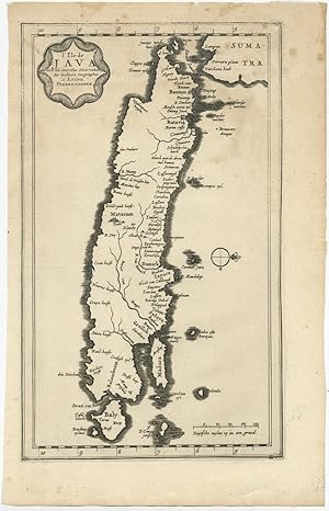
Antique Map of the Island of Java (Indonesia) by P. van der Aa (c.1725)
Verlag: P. van der Aa, 1725
Anbieter: Bartele Gallery - The Netherlands, Langweer, FRL, Niederlande
Verkäuferbewertung 5 von 5 Sternen

Karte
EUR 244,50
Währung umrechnenEUR 17,00 für den Versand von Niederlande nach USAAnzahl: 1 verfügbar
In den WarenkorbNo Binding. Zustand: Good. Antique map titled 'L'Ile de Java'. (The island of Java.) This map shows the Indonesian island of Java. With compass rose and scale. General age-related toning, some staining and small tears. Please study image carefully. Overall size: 19.5 x 21 cm. Image size: 16 x 27 cm.
-
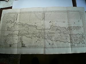
Carte de L ´Ile de Java. Chatelain, anno 1719, very good condition and authentic map Carte de l'Ile de Java: Partie Occidentale, Partie Orientale, Dressee tout Nouvellement Sur Les Memoires Les Plus Exacts; By: Henri Abraham Chatelain Date: 1719 (published) Amsterdam Dimensions: 47x92 cm. (sheet). This is an authentic antique map of the island of Java showing portion of Sumatra and Bali. The map was produced for Chatelain's VII volume world atlas out of Amsterdam in 1719 This is without question, the most elaborate, and accurate large format map of the Island of Java and its coastline of the early 18th century. The city and port of Batavia (Jakarta) can be found in the northwest portion of the island as well as in a large insert in the
Erscheinungsdatum: 1917
Anbieter: Hammelburger Antiquariat, Hammelburg, Deutschland
Verkäuferbewertung 5 von 5 Sternen
Kunst / Grafik / Poster Erstausgabe
EUR 2.400,00
Währung umrechnenEUR 30,00 für den Versand von Deutschland nach USAAnzahl: 1 verfügbar
In den WarenkorbKein Einband. Zustand: Sehr gut. 1. Auflage. Carte de L ´Ile de Java. Chatelain, anno 1719, very good condition and authentic map Carte de l'Ile de Java: Partie Occidentale, Partie Orientale, Dressee tout Nouvellement Sur Les Memoires Les Plus Exacts; By: Henri Abraham Chatelain Date: 1719 (published) Amsterdam Dimensions: 47x92 cm. (sheet). This is an authentic antique map of the island of Java showing portion of Sumatra and Bali. The map was produced for Chatelain's VII volume world atlas out of Amsterdam in 1719 This is without question, the most elaborate, and accurate large format map of the Island of Java and its coastline of the early 18th century. The city and port of Batavia (Jakarta) can be found in the northwest portion of the island as well as in a large insert in the lower left portion of the map. Above the map are two drapery style title banners written by Gueudeville, that present the history of the island as well as the presence of the Dutch. Additional text on either side of the map refer to various cities and villages of Java Condition: Map is in very good condition, with wide margins and a strong impression.
-
Antique Map-The island of Java-Jakarta-Croisey-Bellin-ca. 1780
Erscheinungsdatum: 1780
Anbieter: ThePrintsCollector, Zeeland, Niederlande
Verkäuferbewertung 5 von 5 Sternen
Karte
EUR 249,50
Währung umrechnenEUR 18,00 für den Versand von Niederlande nach USAAnzahl: 1 verfügbar
In den WarenkorbZustand: Good. Antique Map, titled: 'Carte de l'isle de Java.' - Map of Java. From an edition of "L'Hydrographie Francoise Recueil des Cartes Generales et Particulieres qui ont ete Faites pour le Service des Vaisseaux du Roy." by Bellin. Map of Java. Engraving on laid paper. Watermark: Textband Auvergne Made by 'P. Croisey' and published by 'Jacques Nicolas Bellin'. P. Croisey worked around 1770-1800 in Versailles as engraver. Jacques-Nicolas Bellin (1703-1772) was one of the most important cartographers of the 18th century. With a career spanning some 50 years, Bellin is best understood as geographe de cabinet and transitional mapmaker spanning the gap between 18th and early 19th century cartographic styles. Good, given age. Small margins, , with the vertical folds as published, small abrasion in upper rightcorner. General age-related toning and/or occasional minor defects from handling. Please study scan carefully. The overall size is ca. 45.6 x 25 cm. The image size is ca. 43.5 x 21.5 cm. The overall size is ca. 18 x 9.8 inch. The image size is ca. 17.1 x 8.5 inch. Storage location: E47-03.