Carte lile java partie occidentale von chatelain (4 Ergebnisse)

- Softcover
Anbieter: Libreria Anticuaria Camino de Santiago, León - Madrid, LE, SpanienLibreria Anticuaria Camino de Santiago
Verkäufer/-in kontaktierenVerkäufer/-in mit 5 SternenZustand: Gebraucht - Gut
EUR 700,00
EUR 49,10 VersandVersand von Spanien nach USAAnzahl: 1 verfügbar
Zustand: Bueno. 30073 Chatelain 1719 Atlas historique ou nouvelle introduction a l'histoire, à la chronologie & à la geographie ancienne & moderne, Chatelain, 1719. 56x43 cms. SOLICITEN FOTOGRAFÍA Java Maps Soliciten fotos o más información.

Verlag: François L'Honoré & Compagnie Libraries, 1719]., [Amsterdam, 1719
- Karte
Anbieter: Daniel Crouch Rare Books Ltd, London, , Vereinigtes KönigreichDaniel Crouch Rare Books Ltd
Verkäufer/-in kontaktierenVerkäufer/-in mit 4 SternenZustand: Gebraucht
EUR 2.195,57
EUR 23,04 VersandVersand von Vereinigtes Königreich nach USAAnzahl: 1 verfügbar
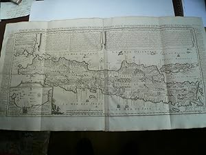
One of the earliest printed detailed charts of Java Large folding engraved map on two sheets joined. The important VOC controlled island of Java, with extensive explanatory text in panels on either side and in banners along the top edge, an inset of Le Port de Batavia appears lower left. The Chatelains based their maps on the wo…rk of contemporary and earlier cartographers and travel writers, and the current map is based on Hadriaan Reland's map, which was not published by the Dutch until Johannes van Keulen, issued it as 'Insulae Iavae pars Occidentalis edente Hadriano Relando' in 1728. VOC knowledge of the southern coastline of Java was only extended much later in 1739, when Paulus Paulusz, master-kaartenmaker in Batavia at the time, led an expedition there.

Verlag: Henri Abraham Chatelain, Amsterdam 1720
- Karte
Anbieter: Antiquariat Reinhold Berg eK Inh. R.Berg, Regensburg, , DeutschlandAntiquariat Reinhold Berg eK Inh. R.Berg
Verkäufer/-in kontaktierenVerkäufer/-in mit 5 SternenZustand: Gebraucht
EUR 850,00
EUR 24,00 VersandVersand von Deutschland nach USAAnzahl: 1 verfügbar
Other. A beautiful example of Henri Chatelain's important 1720 map of Java. The map was produced for Chatelain's 7 volume world atlas out of Amsterdam. Covers the island in full as well as adjacent parts of Sumatra and Bali. The volcanic island of Krakatau, here identified as Cracatao, which nearly 150 years later would erupt wi…th devastating consequences, appears in the Strait of Sunda between Java and Sumatra. In the lower left side is an inset details the city and port of Batavia. Henri Abraham Chatelain (1684 - 1743) was a Huguenot pastor of Parisian origins. He lived consecutively in Paris, St. Martins, London (c. 1710), The Hague (c. 1721) and Amsterdam (c. 1728). He is best known as a Dutch cartographer and more specifically for his cartographic contribution in the seminal seven volume Atlas Historique, published in Amsterdam between 1705 and 1720. Innovative for its time, the Atlas Historique combined fine engraving and artwork with scholarly studies of geography, history, ethnology, heraldry, and cosmography. Some scholarship suggests that the Atlas Historique was not exclusively compiled by Henri Chatelain, as is commonly believed, but rather was a family enterprise involving Henri, his father Zacharie and his brother, also Zacharie. Koeman, Cornelis, Atlantes Neerlandici. Bibliography of Terrestrial, Maritime and Celestial Atlases and Pilot Books, Published in the Netherlands up to 1880, ch 6 (9). Suarez, T., Early Mapping of Southeast Asia, page 232. In two sheets. In excellent condition. Lightstained outside of the image of the map, see illustration. 380 by 880mm (15 by 34¾ inches).
 Weitere Bilder
- Erstausgabe
- Kunstdruck
Anbieter: Hammelburger Antiquariat, Hammelburg, , DeutschlandHammelburger Antiquariat
Verkäufer/-in kontaktierenVerkäufer/-in mit 5 SternenZustand: Gebraucht - Sehr gut
EUR 2.400,00
EUR 30,00 VersandVersand von Deutschland nach USAAnzahl: 1 verfügbar
Kein Einband. Zustand: Sehr gut. 1. Auflage. Carte de L ´Ile de Java. Chatelain, anno 1719, very good condition and authentic map Carte de l'Ile de Java: Partie Occidentale, Partie Orientale, Dressee tout Nouvellement Sur Les Memoires Les Plus Exacts; By: Henri Abraham Chatelain Date: 1719 (published) Amsterdam Dimensions: 47x92… cm. (sheet). This is an authentic antique map of the island of Java showing portion of Sumatra and Bali. The map was produced for Chatelain's VII volume world atlas out of Amsterdam in 1719 This is without question, the most elaborate, and accurate large format map of the Island of Java and its coastline of the early 18th century. The city and port of Batavia (Jakarta) can be found in the northwest portion of the island as well as in a large insert in the lower left portion of the map. Above the map are two drapery style title banners written by Gueudeville, that present the history of the island as well as the presence of the Dutch. Additional text on either side of the map refer to various cities and villages of Java Condition: Map is in very good condition, with wide margins and a strong impression.


