Gesamtpreis (1 Artikel Artikel):
Versandziel:

cercles bavičre franconie souabe divisés von brion tour (3 Ergebnisse)
Direkt zu den wichtigsten Suchergebnissen
Produktart
- Alle Produktarten
- Bücher (2)
- Magazine & Zeitschriften
- Comics
- Noten
- Kunst, Grafik & Poster
- Fotografien
- Karten (1)
-
Manuskripte &
Papierantiquitäten
Zustand
- Alle
- Neu
- Antiquarisch/Gebraucht
Einband
- alle Einbände
- Hardcover
- Softcover
Weitere Eigenschaften
- Erstausgabe
- Signiert
- Schutzumschlag
- Angebotsfoto
- Kein Print-on-Demand
Land des Verkäufers
Verkäuferbewertung
-
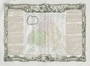
Cercles de Baviere, de Franconie et de Souabe: divisés en toutes leurs Principautés, et Provinces tant Séculičres qu'Ecclesiastiques. Par Mr. Brion Ingr.-Géographe du Roi. ŕ Paris Chez le Sr. Desnos Ing? Géog? pour les Globes et Sphčres, Ruë St. Jacques au Globe. 1766
Erscheinungsdatum: 1771
Karte
Zustand: Good. Cercles de Baviere, de Franconie et de Souabe Germany DESNOS/DE LA TOUR 1771 map. Antique eighteenth century copperplate atlas map with original hand colour, and ornate border. The flanking columns of descriptive text were stuck onto the sheet at the time of publication; Louis Brion de la Tour / Louis Desnos (1771). 56.5 x 44.0cm, 22.25 x 17.25 inches; this is a folding map. Condition: Good. There is nothing printed on the reverse side, which is plain. Circles of Bavaria, Franconia, and Swabia. Southern Germany.
-
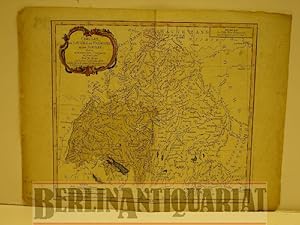
Cercles de Bavičre, de Franconie et de Souabe: divisés en toute leur Principautés et provinces. Altkolorierter Kupferstich mit Flächenkolorit.
Verlag: Desnos, Paris, 1765
Anbieter: BerlinAntiquariat, Karl-Heinz Than, Berlin, Deutschland
Bewertung:

Mit einer Kartusche und mit einer farbigen Schmuckleiste eingefaßt. Mittig einmal gefaltet. Mit stärkeren Gebrauchsspuren besonders am Rand und blaue Flächen (Seen) zum Teil verwischt. Siehe Photo. Bildgröße 23,3 x 26 cm.
-
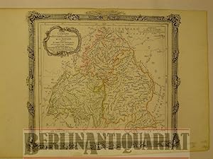
Cercles de Bavičre, de Franconie et de Souabe. Divisés en toutes leurs Principautés, et Séculičres qu' Ecclesiastiques. Altkolorierter Kupferstich mit Grenzkolorit.
Verlag: Desnos, Paris, 1792
Anbieter: BerlinAntiquariat, Karl-Heinz Than, Berlin, Deutschland
Bewertung:
Mit einer Kartusche und mit einer ornamentalen Schmuckleiste eingefaßt. Mittig einmal gefaltet. Geringfügig randgebräunt. Gut erhalten. - Alte Landkarte. Carte ancienne. Old map of Germany, with Baden-Württemberg, Bavaria, Franconia and Swabia. Contemp. col. Surrounded by decorative border. - Foto auf Anfrage. Bildgröße ca. 30 x 28 cm.