Gesamtpreis (1 Artikel Artikel):
Versandziel:

engineer special study surface moon von hackman robert mason arnold (3 Ergebnisse)
Direkt zu den wichtigsten Suchergebnissen
Suchfilter
Produktart
- Alle Product Types
- Bücher (1)
- Magazine & Zeitschriften (Keine weiteren Ergebnisse entsprechen dieser Verfeinerung)
- Comics (Keine weiteren Ergebnisse entsprechen dieser Verfeinerung)
- Noten (Keine weiteren Ergebnisse entsprechen dieser Verfeinerung)
- Kunst, Grafik & Poster (Keine weiteren Ergebnisse entsprechen dieser Verfeinerung)
- Fotografien (Keine weiteren Ergebnisse entsprechen dieser Verfeinerung)
- Karten (2)
- Manuskripte & Papierantiquitäten (Keine weiteren Ergebnisse entsprechen dieser Verfeinerung)
Zustand Mehr dazu
- Neu (Keine weiteren Ergebnisse entsprechen dieser Verfeinerung)
- Wie Neu, Sehr Gut oder Gut Bis Sehr Gut (1)
- Gut oder Befriedigend (1)
- Ausreichend oder Schlecht (Keine weiteren Ergebnisse entsprechen dieser Verfeinerung)
- Wie beschrieben (1)
Einband
- alle Einbände
- Hardcover (Keine weiteren Ergebnisse entsprechen dieser Verfeinerung)
- Softcover (Keine weiteren Ergebnisse entsprechen dieser Verfeinerung)
Weitere Eigenschaften
- Erstausgabe (1)
- Signiert (Keine weiteren Ergebnisse entsprechen dieser Verfeinerung)
- Schutzumschlag (Keine weiteren Ergebnisse entsprechen dieser Verfeinerung)
- Angebotsfoto (3)
- Keine Print-on-Demand Angebote (3)
Sprache (2)
Preis
- Beliebiger Preis
- Weniger als EUR 20 (Keine weiteren Ergebnisse entsprechen dieser Verfeinerung)
- EUR 20 bis EUR 45 (Keine weiteren Ergebnisse entsprechen dieser Verfeinerung)
- Mehr als EUR 45
Gratisversand
- Kostenloser Versand nach USA (Keine weiteren Ergebnisse entsprechen dieser Verfeinerung)
Land des Verkäufers
Verkäuferbewertung
-
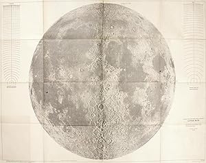
Engineer special study of the surface of the moon. 4 folded maps, each 98 x 144 cm. Map 1: Generalized Photogeologic Map of the Moon; Map 2: Lunar Rays. Map 3: Physiographic Divisions of the Moon; Map 4: Text in which Mason assessed in writing the landing, travel, and construction conditions in each of the physiographic regions on Map 3.
Sprache: Englisch
Verlag: Washington D C: Army Map Service Corps of Engineers, 1960
Anbieter: Antiquariat Dr. Lorenz Kristen, Berlin, Deutschland
Verkäuferbewertung 5 von 5 Sternen

EUR 3.850,00
EUR 27,75 Versand
Versand von Deutschland nach USAAnzahl: 1 verfügbar
In den WarenkorbIm original Umschlag (der Umschlag mit ein paar Knickspuren [vgl. Abbildung], eine Karte mit einer leichten Knickspur an der rechten unteren Ecke, sonst absolut tadellose, offenbar bisher kaum aufgefaltete Exemplare). //// In the original envelope (the envelope with a few crease marks [see illustration], map 3 with a slight crease mark at the lower right corner, otherwise absolutely pristine, apparently hardly ever unfolded copies). Erste Ausgabe der ersten Versuchs, Mondmerkmale für wissenschaftliche und technische Zwecke zu kartieren, einschließlich der ersten großen Mondkarte, die stratigrafische Beziehungen zeigt. In diesem Zustand wirklich selten. - Cf. Online Source: USGS Astrogeologic Science Center, 1961: USGS Astrogeology's First Published Map. //// First edition of the first attempt to map lunar features for scientific and technical purposes, including the first large lunar map showing stratigraphic relationships. Truly rare in this condition. - Cf. Online Source: USGS Astrogeologic Science Center, 1961: USGS Astrogeology's First Published Map. --------------------------------------------------------------------- ------------------------------------------------------------ ------------------------------------------------------------ ------------------------------- BITTE BEACHTEN: Auf Grund der absurden und irrsinnig teuren staatlichen Regelungen für die Entsorgung der Versandpappen in den nachfolgenden Ländern, kann ich leider nicht mehr liefern nach: Österreich, Griechenland, Polen. Kunden in ÖSTERREICH können sich aber an die einheimische Post wenden, dort unter Alles Post Deutschland. --- PLEASE NOTE: Due to the absurd and insanely expensive government regulations for the disposal of shipping cartons in the following countries, I can unfortunately no longer deliver to: Austria, Greece, Poland. However, customers in AUSTRIA can contact their local post office, there under Alles Post Deutschland.
-
Engineer special study of the surface of the moon - Lunar Rays
Sprache: Englisch
Verlag: Army Map Service, Corps of Engineers, Washington, D.C., 1960
Anbieter: Milestones of Science Books, Ritterhude, Deutschland
Verkäuferbewertung 5 von 5 Sternen
Karte Erstausgabe
EUR 2.000,00
EUR 45,00 Versand
Versand von Deutschland nach USAAnzahl: 1 verfügbar
In den WarenkorbNo Binding. Zustand: Very Good. 1st Edition. 1 folding map, 1440 x 975 mm, image size 1275 x 940 mm. Light yellowing of paper, some paper thinness on old folds, but generally in a very good condition. ---- VERY RARE FIRST EDITION. The Army Corps of Engineers published the first edition of Arnold Mason and Robert Hackman's four-sheet Engineer Special Study of the Surface of the Moon map set in July 1960. The USGS published a second edition with "minor revisions" in 1961. "Even after the creation of NASA, the Army and USAF studied lunar surface bases . The USAF also began lunar mapping using Earth-based telescopes. The first attempt to map lunar features for scientific and engineering purposes did not, however, originate within the Defense Department. It was begun instead by Arnold Mason of the U.S. Geological Survey (USGS) Military Geology Branch in Washington, DC. . Early in 1959 - soon after Luna 1 - Mason proposed to carry out an analysis of the moon's terrains to determine their suitability for spacecraft landings, travel on foot and by rover, and base construction . he enlisted Robert Hackman and Annabel Brown Olson of the USGS Photogeology Branch in his project . At first, they had available only meager USGS funds. Soon after Luna 2 and Luna 3, however, the Army Corps of Engineers funded their study . They based their analysis on photographic plates from large telescopes on Earth, which under the best viewing conditions could (they estimated) reveal features on the moon no smaller than about a mile across. In fact, features 10 miles wide were barely discernible in most of the photographic images they used. Their work soon drew in as consultants lunar experts Gerard Kuiper (McDonald Observatory), Eugene Shoemaker (USGS Menlo Park), and Robert Dietz (Naval Electronics Laboratory). All three supported the impact hypothesis, which stated that most of the moon's craters are asteroid impact scars; not, as some believed, volcanic calderas. At the time, planetary astronomer Kuiper was hard at work on a USAF-funded lunar photographic atlas; Mason and Hackman would use it near the end of their study. Shoemaker, meanwhile, was busy refining a prototype lunar geologic map of the region containing the large, relatively young crater Copernicus; Hackman would later assist him with identification of lineaments in the Copernicus region. In this sheet 2 of the "Engineer Special Study," titled "Lunar Rays," Mason and Hackman plotted the source craters and extent of the moon's most prominent ray systems . They correctly identified the light-hued rays as ejecta blasted out from young asteroid impact craters." (Online Source: USGS Astrogeologic Science Center, 1961: USGS Astrogeology's First Published Map).
-
Engineer Special Study of the Surface of the Moon - Lunar Rays. ++Beautiful and Huge Map of the Moon++
Verlag: U.S. Geological Survey, 1961
Anbieter: JF Ptak Science Books, Hendersonville, NC, USA
Verkäuferbewertung 5 von 5 Sternen
Karte
No Binding. Zustand: Fine. 2nd Edition. Massive and Beautiful Map of the Moon, 1961. (Moon Map) HACKMAN, Robert; MASON, Arnold. (Astrogeology Science Center.) Engineer special study of the surface of the moon - Lunar Rays. Washington, D.C. Army Map Service, Corps of Engineers, 1961. Fine, crisp copy. Probably an 8/10 rating. As you can see I did not try to open this map fully and flatten it, so it appears that shadow may be yellowing, but there is NO yellowing in this map. [++] "Second edition", 1961 (following the first printing July 1960.) Very large folding (wall) map, 1440 x 975 mm, 40"x50", scale approx 1:3,800,000. So far as I can determine from the resistance to unfolding, this map has been very little used and unfolded. That said, there are a few areas where there is a possibility of a short tear at some of the folds. The map is very crisp and bright really, quite lovely. This is one of four maps in this series published by the U.S. Geological Survey all four are available online as downloadable pdfs from the USGS publications website. [++] "Arnold Mason and Robert Hackman correctly identified light-hued rays as ejecta blasted out from young asteroid impact craters."--USGS site (searched under this title).