Gesamtpreis (1 Artikel Artikel):
Versandziel:

large ordnance survey map sheet von ordnance survey (16 Ergebnisse)
Feedback
Direkt zu den wichtigsten Suchergebnissen
Suchfilter
Produktart
- Alle Product Types
- Bücher (9)
- Magazine & Zeitschriften (Keine weiteren Ergebnisse entsprechen dieser Verfeinerung)
- Comics (Keine weiteren Ergebnisse entsprechen dieser Verfeinerung)
- Noten (Keine weiteren Ergebnisse entsprechen dieser Verfeinerung)
- Kunst, Grafik & Poster (Keine weiteren Ergebnisse entsprechen dieser Verfeinerung)
- Fotografien (Keine weiteren Ergebnisse entsprechen dieser Verfeinerung)
- Karten (7)
- Manuskripte & Papierantiquitäten (Keine weiteren Ergebnisse entsprechen dieser Verfeinerung)
Zustand
- Alle
- Neu (Keine weiteren Ergebnisse entsprechen dieser Verfeinerung)
- Antiquarisch (16)
Einband
- alle Einbände
- Hardcover (Keine weiteren Ergebnisse entsprechen dieser Verfeinerung)
- Softcover (3)
Weitere Eigenschaften
- Erstausgabe (Keine weiteren Ergebnisse entsprechen dieser Verfeinerung)
- Signiert (Keine weiteren Ergebnisse entsprechen dieser Verfeinerung)
- Schutzumschlag (Keine weiteren Ergebnisse entsprechen dieser Verfeinerung)
- Angebotsfoto (16)
- Keine Print-on-Demand Angebote (16)
Sprache (2)
Gratisversand
- Kostenloser Versand nach Deutschland (Keine weiteren Ergebnisse entsprechen dieser Verfeinerung)
Land des Verkäufers
Verkäuferbewertung
-
Buckingham, Leighton Buzzard and Luton. Sheet 96, Ordnance Survey One Inch Map (Large Sheet Series), Third Edition
Verlag: Ordnance Survey, 1914
Sprache: Englisch
Anbieter: Nigel Smith Books, Gunnislake, Vereinigtes Königreich
Verkäuferbewertung 5 von 5 Sternen

Karte
EUR 15,31
Währung umrechnenEUR 14,80 für den Versand von Vereinigtes Königreich nach DeutschlandAnzahl: 1 verfügbar
In den WarenkorbMap. Zustand: Fair. Folded map, mounted on linen, some foxing, wear and tanning to folds and small holes where the folds cross, else map is still bright and clean; linen has some foxing, title is printed on linen back, outer panels are rather grubby, discoloured and marked. Revised 1905, railways revised 1914. Print code 7.14.
-
Buckingham, Leighton Buzzard and Luton. Sheet 96, Ordnance Survey One Inch Map (Large Sheet Series), Third Edition
Verlag: Ordnance Survey, 1914
Sprache: Englisch
Anbieter: Nigel Smith Books, Gunnislake, Vereinigtes Königreich
Verkäuferbewertung 5 von 5 Sternen
Karte
EUR 15,31
Währung umrechnenEUR 14,80 für den Versand von Vereinigtes Königreich nach DeutschlandAnzahl: 1 verfügbar
In den WarenkorbMap. Zustand: Fair. Folded map, mounted on linen, some foxing, wear and tanning to folds and small holes where the folds cross, else map is still bright and clean; linen has some foxing, card covers are heavily foxed and marked with previous owner's name on front. Revised 1905, railways revised 1914. Print code 7.14.
-
Liverpool, Southport and Chester. Sheet 34, Ordnance Survey One Inch Map (Large Sheet Series), Third Edition
Verlag: Ordnance Survey, 1913
Sprache: Englisch
Anbieter: Nigel Smith Books, Gunnislake, Vereinigtes Königreich
Verkäuferbewertung 5 von 5 Sternen
Karte
EUR 18,36
Währung umrechnenEUR 14,80 für den Versand von Vereinigtes Königreich nach DeutschlandAnzahl: 1 verfügbar
In den WarenkorbMap. Zustand: Good. Folded map, mounted on linen, some wear to folds and small holes where the folds cross, map is still bright and clean; linen has some foxing, card covers are heavily foxed and marked. Revised 1904-12, published 1913. Coverage: NW Southport, NE Chorley, SW Mwynbwll, SE Little Budworth Common.
-

1:2500 Ordnance Survey Map, Leicestershire Sheet XIV.1, Second Edition 1904, Surveyed in 1884, Revised in 1902, Reprint 40/41, Large-scale plan of the area north of the village of Saltby in Leicestershire
Verlag: Ordnance Survey, 1904
Anbieter: Bailgate Books Ltd, Doncaster, Vereinigtes Königreich
Verkäuferbewertung 5 von 5 Sternen
Karte
EUR 11,64
Währung umrechnenEUR 9,51 für den Versand von Vereinigtes Königreich nach DeutschlandAnzahl: 1 verfügbar
In den WarenkorbSingle sheet. Zustand: Very Good. Zustand des Schutzumschlags: No Dust Jacket. Revised Edition. Includes: Saltby Lodge, farm (Swallow Hole Farm), farm (Barn Lodge Farm) , farm (Heath Farm), Swallowhole Covert, Swallow Hole (geological feature), Bescaby Oaks and Croxton Park (Old Wood). Parts of parishes included are: Saltby, Bescaby and Croxton Kerrial. The area is in the Melton Mowbray Union & RD and Grantham Union and Bevoir RD. Information included is buildings, property/field boundaries, acreage, parish and other boundaries, footpaths, tracks, roads, railways, watercourses, orchards and forestation, levels, earthworks, antiquities etc. The map has an inked stamp in the bottom margin and reference number in the bottom right corner (margin). Item Type: Map. Quantity Available: 1. Shipped Weight: under 1 kg. Pictures of this item not already displayed here available upon request. Inventory No: 45110120060. All our books are sent by tracked mail.
-

1:2500 Ordnance Survey Map, Yorkshire (East Riding) Sheet CXCII 13, Edition of 1910, Re-Surveyed in 1890, Revised in 1908, Reprint 25/45 Wa, Large-scale plan of the area between the villages of Wheldrake, Thorganby and Escrick, SE of York.
Verlag: Ordnance Survey, 1908
Anbieter: Bailgate Books Ltd, Doncaster, Vereinigtes Königreich
Verkäuferbewertung 5 von 5 Sternen
Karte
EUR 11,64
Währung umrechnenEUR 9,51 für den Versand von Vereinigtes Königreich nach DeutschlandAnzahl: 1 verfügbar
In den WarenkorbSingle sheet. Zustand: Very Good. Zustand des Schutzumschlags: No Dust Jacket. Revised Edition. Large-scale plan of the area between the villages of Wheldrake, Thorganby and Escrick, SE of York. Map shows; part Leonard Scales Lane, South Plantation, South Close, Keld Carrs, Keld Carrs Drain, Simpson's Wood, Crinklety's Wood, Common Drain, Common Lane, Common Bottoms Wood, Westhow Field, Westhow Closes, Sandhole Lane, Common Farm, Southmoor Drain, South moor, Poor's Close, Pallion Dike, Gray Reins, Acorn Plantation, West Cottingwith Common, Keldcarrs Plantation, Gilbertson's Wood, Gilbertson's Farm, Wheldrake Wrays and Grange Farm. Includes parts of Thorganby with West Cottingwith, Escrick and Wheldrake Parish and York Union & Escrick RD along with Howdenshire Division. Information included is buildings, property/field boundaries, acreage, parish and other boundaries, footpaths, tracks, roads, railways, watercourses, orchards and forestation, levels, earthworks, antiquities etc. The map has a small area of faint 'ink spots', and an ID number in the bottom RH margin. Minor closed tears to margins with slight creasing to map. Item Type: Map. Quantity Available: 1. Shipped Weight: under 1 kg. Pictures of this item not already displayed here available upon request. Inventory No: 45110120066. All our books are sent by tracked mail.
-
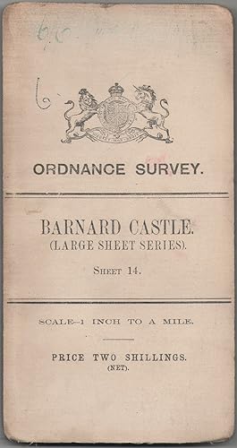
Ordnance Survey Map of England & Wales. Sheet 14. Barnard Castle. Large Sheet Series
Verlag: Ordnance Survey, Southampton, 1907
Anbieter: Anvil Books, Prestatyn, FLINT, Vereinigtes Königreich
Verkäuferbewertung 5 von 5 Sternen
Karte
EUR 14,69
Währung umrechnenEUR 11,89 für den Versand von Vereinigtes Königreich nach DeutschlandAnzahl: 1 verfügbar
In den WarenkorbMap. Zustand: Good. No Jacket. 3rd Edition. Revised in 1904. 1 inch to 1 mile, 28 x 20 inches, 24 panels, mounted on linen, sl wear at folds, sl foxing, inscr on front cover.
-
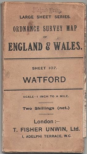
Ordnance Survey Map of England & Wales. Sheet 107. Watford. Large Sheet Series
Verlag: Ordnance Survey, Southampton, 1908
Anbieter: Anvil Books, Prestatyn, FLINT, Vereinigtes Königreich
Verkäuferbewertung 5 von 5 Sternen
Karte
EUR 14,69
Währung umrechnenEUR 11,89 für den Versand von Vereinigtes Königreich nach DeutschlandAnzahl: 1 verfügbar
In den WarenkorbMap. Zustand: Good. No Jacket. 3rd Edition. Revised in 1902, railways revised in May 1912, minor corrections Feb 1910. 1 inch to 1 mile, 30 x 20 inches, 24 panels, mounted on linen, sl wear at folds, sl foxing, stamp on front cover, inscr on rear cover.
-
Large Hand Coloured Geological Ordnance Survey MAP SHEET 12 Basingstoke Hampshire Geological Survey of England & Wales Scale 1 inch to 1 mile.
Verlag: Geological Survey of England & Wales Colonel Colby 1860 Revised 1885, 1885
Anbieter: PROCTOR / THE ANTIQUE MAP & BOOKSHOP, DORCHESTER, Vereinigtes Königreich
Verbandsmitglied: PBFA
Verkäuferbewertung 5 von 5 Sternen
EUR 24,48
Währung umrechnenEUR 13,01 für den Versand von Vereinigtes Königreich nach DeutschlandAnzahl: 1 verfügbar
In den WarenkorbOriginal rolled flat map. Hand-coloured engraving With ORDNANCE SURVEY Blind Stamp top margin. Size 33.5 inches X 26.5 inches. 84cm x 66cm Ordnance survey map showing Basingstoke, Whitchurch, Andover & surrounding areas. In good condition. Some foxing & a little dusty on margins & tear on right hand side of map. A few small nicks top edge. Unfolded. It will be rolled up and posted in a poster tube.
-

LARGE Ordnance Survey MAP Sheet XLIV.6 Trinidad Estate Branksome - Bourne Valley Poole DORSET Scale 1:2500 or 25.344 inches to 1 mile.
Verlag: ORDNANCE SURVEY 1937, 1937
Anbieter: PROCTOR / THE ANTIQUE MAP & BOOKSHOP, DORCHESTER, Vereinigtes Königreich
Verbandsmitglied: PBFA
Verkäuferbewertung 5 von 5 Sternen
EUR 24,48
Währung umrechnenEUR 13,01 für den Versand von Vereinigtes Königreich nach DeutschlandAnzahl: 1 verfügbar
In den WarenkorbOriginal Folded flat map. Approximate size is 100cm x 74cm. Shows areas of Newtown, Trinidad Estate Branksome - Bourne Valley Wallisdown Poole. In good condition. Some light rubbing on edges. Small pin holes in corners. Small nick top & bottom edge. A little creased on corners. With vertical and horizontal folds. It will be rolled up and posted in a poster tube.
-

LARGE Ordnance Survey MAP Sheet XXXV.14 DORSET. Knighton & Canford Magna, Bear Wood. Scale 1:2500 or 25.344 inches to 1 mile.
Verlag: ORDNANCE SURVEY 1934, 1934
Anbieter: PROCTOR / THE ANTIQUE MAP & BOOKSHOP, DORCHESTER, Vereinigtes Königreich
Verbandsmitglied: PBFA
Verkäuferbewertung 5 von 5 Sternen
EUR 24,48
Währung umrechnenEUR 13,01 für den Versand von Vereinigtes Königreich nach DeutschlandAnzahl: 1 verfügbar
In den WarenkorbOriginal Folded flat map. Approximate size is 100cm x 74cm. Shows areas of Knighton & Canford Magna, Bear Wood In good condition. Some light rubbing on edges, with a few small creases lightly tanned. With vertical and horizontal folds. County Borders Changed in 1974 From Hampshire to Dorset It will be rolled up and posted in a poster tube.
-

Large Hand Coloured Geological Ordnance Survey MAP SHEET 47 S.W Essex Geological Survey of England & Wales Scale 1 inch to 1 mile.
Verlag: Geological Survey of England & Wales 1884, 1884
Anbieter: PROCTOR / THE ANTIQUE MAP & BOOKSHOP, DORCHESTER, Vereinigtes Königreich
Verbandsmitglied: PBFA
Verkäuferbewertung 5 von 5 Sternen
EUR 26,93
Währung umrechnenEUR 13,01 für den Versand von Vereinigtes Königreich nach DeutschlandAnzahl: 1 verfügbar
In den WarenkorbOriginal rolled flat map. Hand-coloured engraving With ORDNANCE SURVEY Blind Stamp top margin. Size 40 inches X 26.5 inches. 100cm x 68cm Ordnance survey map showing Saffron Walden, Whitham, Royston & surrounding areas. In generally good condition. Some foxing & a little dusty on margins & right hand side. A few small nicks on edges, a little tatty top left corner. Unfolded. It will be rolled up and posted in a poster tube.
-
Large Hand Coloured Geological Ordnance Survey MAP SHEET 8 Guildford SURREY Geological Survey of England & Wales Scale 1 inch to 1 mile.
Verlag: Geological Survey of England & Wales Colonel Colby 1816 Revised 1891, 1891
Anbieter: PROCTOR / THE ANTIQUE MAP & BOOKSHOP, DORCHESTER, Vereinigtes Königreich
Verbandsmitglied: PBFA
Verkäuferbewertung 5 von 5 Sternen
EUR 34,28
Währung umrechnenEUR 13,01 für den Versand von Vereinigtes Königreich nach DeutschlandAnzahl: 1 verfügbar
In den WarenkorbOriginal rolled flat map. Hand-coloured engraving With ORDNANCE SURVEY Blind Stamp top margin. Size 33.5 inches X 26 inches. 85cm x 66cm Ordnance survey map showing Guildford & surrounding areas. In good condition. Some foxing & a little dusty on margins. Margin has small tear on left, crease down right hand margin, Top edge a little nicked with one tear. MAP not affected by edge nicks etc. Unfolded. It will be rolled up and posted in a poster tube.
-

Large Hand Coloured Geological Ordnance Survey MAP SHEET 12 Basingstoke Hampshire Geological Survey of England & Wales Scale 1 inch to 1 mile.
Verlag: Geological Survey of England & Wales Colonel Colby 1860 Revised 1885, 1885
Anbieter: PROCTOR / THE ANTIQUE MAP & BOOKSHOP, DORCHESTER, Vereinigtes Königreich
Verbandsmitglied: PBFA
Verkäuferbewertung 5 von 5 Sternen
EUR 40,40
Währung umrechnenEUR 13,01 für den Versand von Vereinigtes Königreich nach DeutschlandAnzahl: 1 verfügbar
In den WarenkorbOriginal rolled flat map. Hand-coloured engraving With ORDNANCE SURVEY Blind Stamp top margin. Size 32.5 inches X 27.5 inches. 82cm x 70cm Ordnance survey map showing Basingstoke, Whitchurch, Andover & surrounding areas. In good condition. Some foxing & a little dusty on margins & slightly on right hand side of map. A few small nicks lower edge. Unfolded. It will be rolled up and posted in a poster tube.
-

Large Hand Coloured Geological Ordnance Survey MAP SHEET 7 LONDON including River Thames Middlesex Geological Survey of England & Wales Scale 1 inch to 1 mile.
Verlag: Geological Survey of England & Wales Colonel Colby 1822 Revised 1885, 1885
Anbieter: PROCTOR / THE ANTIQUE MAP & BOOKSHOP, DORCHESTER, Vereinigtes Königreich
Verbandsmitglied: PBFA
Verkäuferbewertung 5 von 5 Sternen
EUR 67,33
Währung umrechnenEUR 13,01 für den Versand von Vereinigtes Königreich nach DeutschlandAnzahl: 1 verfügbar
In den WarenkorbOriginal rolled flat map. Hand-coloured engraving With ORDNANCE SURVEY Blind Stamp top margin. Size 39.5 inches X 27 inches. 100cm x 69cm Ordnance survey map showing Uxbridge, Windsor, Watford Chelsea & surrounding areas. In generally good condition. Some foxing & a little dusty on margins & 2 tears together on top edge of map. A few small nicks on edges. Unfolded. It will be rolled up and posted in a poster tube.
-
Large Hand Coloured Geological Ordnance Survey MAP SHEET 13 OXFORD, OXFORDSHIRE Geological Survey of England & Wales Scale 1 inch to 1 mile.
Verlag: Geological Survey of England & Wales Colonel Colby 1830 Revised 1891, 1891
Anbieter: PROCTOR / THE ANTIQUE MAP & BOOKSHOP, DORCHESTER, Vereinigtes Königreich
Verbandsmitglied: PBFA
Verkäuferbewertung 5 von 5 Sternen
EUR 67,33
Währung umrechnenEUR 13,01 für den Versand von Vereinigtes Königreich nach DeutschlandAnzahl: 1 verfügbar
In den WarenkorbOriginal rolled flat map. Hand-coloured engraving With ORDNANCE SURVEY Blind Stamp top margin. Size 33.5 inches X 26 inches. 85cm x 66cm Ordnance survey map showing areas Abingdon, Oxford, Chilton. In very good condition. Some foxing & a little dusty on margins. Unfolded. It will be rolled up and posted in a poster tube.
-

LARGE Ordnance Survey MAP Sheet LI. 5 DORSET. Brownsea Island (Ferry Side) Sandbanks Scale 1:2500 or 25.344 inches to 1 mile.
Verlag: ORDNANCE SURVEY 1933, 1933
Anbieter: PROCTOR / THE ANTIQUE MAP & BOOKSHOP, DORCHESTER, Vereinigtes Königreich
Verbandsmitglied: PBFA
Verkäuferbewertung 5 von 5 Sternen
EUR 67,33
Währung umrechnenEUR 13,01 für den Versand von Vereinigtes Königreich nach DeutschlandAnzahl: 1 verfügbar
In den WarenkorbOriginal Folded flat map. Approximate size is 100cm x 74cm. Shows areas of Brownsea Island (Ferry Side) Sandbanks, Studland Heath, Poole Bay. In good condition. Some light rubbing on edges, with a few small corner creases & lightly tanned. With a few vertical and horizontal folds. It will be rolled up and posted in a poster tube.