Gesamtpreis (1 Artikel Artikel):
Versandziel:

map paris von society diffusion useful knowledge (3 Ergebnisse)
Direkt zu den wichtigsten Suchergebnissen
Suchfilter
Produktart
- Alle Product Types
- B■cher (Keine weiteren Ergebnisse entsprechen dieser Verfeinerung)
- Magazine & Zeitschriften (Keine weiteren Ergebnisse entsprechen dieser Verfeinerung)
- Comics (Keine weiteren Ergebnisse entsprechen dieser Verfeinerung)
- Noten (Keine weiteren Ergebnisse entsprechen dieser Verfeinerung)
- Kunst, Grafik & Poster (2)
- Fotografien (Keine weiteren Ergebnisse entsprechen dieser Verfeinerung)
- Karten (1)
- Manuskripte & Papierantiquitðten (Keine weiteren Ergebnisse entsprechen dieser Verfeinerung)
Zustand Mehr dazu
- Neu (Keine weiteren Ergebnisse entsprechen dieser Verfeinerung)
- Wie Neu, Sehr Gut oder Gut Bis Sehr Gut (2)
- Gut oder Befriedigend (Keine weiteren Ergebnisse entsprechen dieser Verfeinerung)
- Ausreichend oder Schlecht (Keine weiteren Ergebnisse entsprechen dieser Verfeinerung)
- Wie beschrieben (1)
Einband
- alle Einbðnde
- Hardcover (Keine weiteren Ergebnisse entsprechen dieser Verfeinerung)
- Softcover (1)
Weitere Eigenschaften
- Erstausgabe (1)
- Signiert (Keine weiteren Ergebnisse entsprechen dieser Verfeinerung)
- Schutzumschlag (Keine weiteren Ergebnisse entsprechen dieser Verfeinerung)
- Angebotsfoto (3)
- Keine Print-on-Demand Angebote (3)
Sprache (1)
Preis
- Beliebiger Preis
- Weniger als EUR 20 (Keine weiteren Ergebnisse entsprechen dieser Verfeinerung)
- EUR 20 bis EUR 45 (Keine weiteren Ergebnisse entsprechen dieser Verfeinerung)
- Mehr als EUR 45
Gratisversand
- Kostenloser Versand nach USA (Keine weiteren Ergebnisse entsprechen dieser Verfeinerung)
Land des Verkðufers
Verkðuferbewertung
-
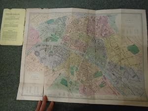
Map of Paris
Verlag: Published by Edward Stanford no date given c1870, London, 1870
Anbieter: Keoghs Books, Skipton, Vereinigtes K—nigreich
Verbandsmitglied: PBFA
Verkðuferbewertung 5 von 5 Sternen

Karte Erstausgabe
EUR 88,89
EUR 32,22 Versand
Versand von Vereinigtes K—nigreich nach USAAnzahl: 1 verf■gbar
In den Warenkorb, fold out coloured map on card of Paris First Edition , spine torn along most of its length, edges of covers very worn with pieces missing, title label rubbed, edges of map worn, folds worn and some split with some loss to map, small split to fold near the bottom of the map, fair condition , card map in card covers , 19 x 12 cm (folded), 43 x 58 cm (open) Paperback ISBN:
-

Map of the Environs of Paris, France
Verlag: London, 1857
Anbieter: Trillium Antique Prints & Rare Books, Franklin, TN, USA
Verkðuferbewertung 4 von 5 Sternen

Kunst / Grafik / Poster
Zustand: Fine. This originally hand-colored engraving is from "The Complete Atlas of Modern, Classical and Celestial Maps, together with Plans of the Principal Cities of the World". The work was published in 1857 by Edward Stanford for the Society for the Diffusion of Useful Knowledge. --- The work is in very good to excellent condition. There may be a few minor imperfections to be expected with age. Please review the image carefully for condition and contact us with any questions. --- Paper Size ~ 14" by 16 7/8".
-

Map of Paris, France (in two sheets)
Verlag: London, 1857
Anbieter: Trillium Antique Prints & Rare Books, Franklin, TN, USA
Verkðuferbewertung 4 von 5 Sternen
Kunst / Grafik / Poster
Zustand: Fine. This originally hand-colored engraving is from "The Complete Atlas of Modern, Classical and Celestial Maps, together with Plans of the Principal Cities of the World". The work was published in 1857 by Edward Stanford for the Society for the Diffusion of Useful Knowledge. --- The work is in very good to excellent condition. There may be a few minor imperfections to be expected with age. Please review the image carefully for condition and contact us with any questions. - The map is to two sheets, both are shown here with one digitally stitched together to show how it can look joined. --- Paper Size ~ 14" by 16 7/8".