
Gesamtpreis (1 Artikel Artikel):
Versandziel:

map vermont von colton j h (5 Ergebnisse)
Direkt zu den wichtigsten Suchergebnissen
Produktart
- Alle Produktarten
- Bücher (4)
- Magazine & Zeitschriften
- Comics
- Noten
- Kunst, Grafik & Poster (1)
- Fotografien
- Karten
-
Manuskripte &
Papierantiquitäten
Zustand
- Alle
- Neu
- Antiquarisch/Gebraucht
Einband
- alle Einbände
- Hardcover
- Softcover (2)
Weitere Eigenschaften
- Erstausgabe (1)
- Signiert
- Schutzumschlag
- Angebotsfoto (4)
- Kein Print-on-Demand
Land des Verkäufers
Verkäuferbewertung
-
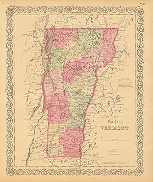
This political map was issued as part of J.H. Coltons's 1860 School Atlas. We consider Colton to be the premier mapmaker in American history. His maps are known for their precision and attention to detail. This map measures 12 inches by 9.75 inches.
-

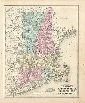
Pamphlet. Zustand: Good. Map is 18.5 x 16 inches, Elaborate border, Hand-WaterColored in Pastels, 1 inch area of extreme upper right corner slightly toned but scarcely visible, else Attractive & Could be Beautifully Framed (Map is dated 1855).
-

MAP: "Johnson's Map of New Hampshire & Vermont (1861)'.from Johnson's New Illustrated (Steel Plate) Family Atlas, 1861
Verlag: Johnson & Browning, Richmond, VA, 1861
Kunst / Grafik / Poster Erstausgabe
Unbound. Zustand: Very Good. Handcolored Map (illustrator). 1st. Plate #23, 24: lovely double page hand-colored map; mid-19th century, decorative strapwGreen Mountains indicated, , railroads and canals as well. Lower right quadrant goes beyond the bordering as shown. Size: 17 x 24.5 Inches.
-
We are pleased to offer this map issued as part of Colton's General Atlas, published in 1865. The Civil War ended April 9, 1865 and this atlas was one of the first post-Civil War atlas' published. Colton continued his tradition of beautiful hand coloring with this atlas. This map measures 16 inches by 13 inches.
-
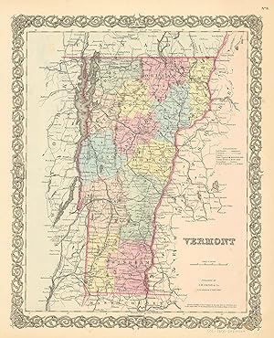
Joseph Hutchins Colton (1800-1893) started one of the premier map publishing firms in the U.S. His first printed map dated 1833, was a reprint of David Burrs map of the state of New York. The Colton firm was one of the primary publishers of guidebooks, immigrant maps, and railroad maps. In 1855 Colton issued his first atlas, "Colton's Atlas of the World." They refused to compromise quality, choosing to compete for sales in the finer quality international market rather than the inexpensive domestic one. Because of this, all maps were engraved by steel plates rather than by wax engraving which was the most common method used at this time. This map is very detailed with identification of provinces and or regions, cities, towns and villages, transportation routes including rail roads, common roads, and canals, rivers and lakes, battle fields, and mountain ranges. Each map has beautiful muted red, green, tan, pink, and yellow hand coloring. Art Source International is proud and excited to offer maps from this very rare atlas. We have been in the antique map business for over forty years and these are the true first edition maps (1855) we have ever offered. Don't wait too long to purchase this piece of American mapping history! This map measures 16 inches by 12.5 inches.
