Gesamtpreis (1 Artikel Artikel):
Versandziel:

maps measurement (12 Ergebnisse)
Direkt zu den wichtigsten Suchergebnissen
Suchfilter
Produktart
- Alle Product Types
- Bücher (10)
- Magazine & Zeitschriften (2)
- Comics (Keine weiteren Ergebnisse entsprechen dieser Verfeinerung)
- Noten (Keine weiteren Ergebnisse entsprechen dieser Verfeinerung)
- Kunst, Grafik & Poster (Keine weiteren Ergebnisse entsprechen dieser Verfeinerung)
- Fotografien (Keine weiteren Ergebnisse entsprechen dieser Verfeinerung)
- Karten (Keine weiteren Ergebnisse entsprechen dieser Verfeinerung)
- Manuskripte & Papierantiquitäten (Keine weiteren Ergebnisse entsprechen dieser Verfeinerung)
Zustand Mehr dazu
- Neu (2)
- Wie Neu, Sehr Gut oder Gut Bis Sehr Gut (1)
- Gut oder Befriedigend (4)
- Ausreichend oder Schlecht (Keine weiteren Ergebnisse entsprechen dieser Verfeinerung)
- Wie beschrieben (5)
Einband
Weitere Eigenschaften
- Erstausgabe (2)
- Signiert (1)
- Schutzumschlag (Keine weiteren Ergebnisse entsprechen dieser Verfeinerung)
- Angebotsfoto (3)
- Keine Print-on-Demand Angebote (12)
Sprache (2)
Gratisversand
Land des Verkäufers
Verkäuferbewertung
-

SPECIAL FEATURE: COGNITION AND PERCEPTION - Scaling Techniques in the Analysis of Environmental Cognition Data + Distance Cognition in Urban Environments + On the Sensitivity of Conclusions About the Bases of Cognitive Distance + The Cognitive Maps of Adolescents: Confusion About Inter-town Distances + Any Place But Here! Mental Health Facilities as Noxious Neighbors + Whose Image of What? A Note on the Measurement of Industrialists' Attitudes and Images
Sprache: Englisch
Verlag: Prof Geog, 1981
Anbieter: Larry W Price Books, Portland, OR, USA
Verkäuferbewertung 5 von 5 Sternen

Magazin / Zeitschrift
Paperback. Zustand: Very Good. Vol 33, No 3, pp. 294-340, Illus, Orig Journal (Entire Issue), VG.
-
ERROR ON CHOROPLETHIC MAPS: DEFINITION, MEASUREMENT, REDUCTION
Verlag: Annals Assoc Amer Geog, 1971
Anbieter: Larry W Price Books, Portland, OR, USA
Verkäuferbewertung 5 von 5 Sternen
Magazin / Zeitschrift
Pamphlet. Zustand: Very Good. Vol 61, No 2, pp. 217-244, Maps, Illus, Extracted from orig vol, then Recased in Orig Journal Covers, name on cover else VG.
-
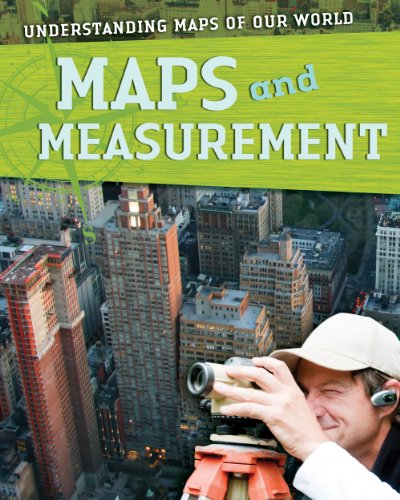
Maps and Measurement
Sprache: Englisch
Verlag: Stevens Publishing LLLP, Gareth, 2010
ISBN 10: 1433935031 ISBN 13: 9781433935039
Anbieter: Better World Books, Mishawaka, IN, USA
Verkäuferbewertung 5 von 5 Sternen
Zustand: Good. Former library copy. Pages intact with minimal writing/highlighting. The binding may be loose and creased. Dust jackets/supplements are not included. Includes library markings. Stock photo provided. Product includes identifying sticker. Better World Books: Buy Books. Do Good.
-
The Contour' Road Book of England, a Series of Elevation Plans ofthe Roads with Measurement and Description Letterpress. With 500 Diagrams & Maps, Extensivelely altered 1912 - 1913
Verlag: Gall & Inglis, London, 1912
Anbieter: Bailgate Books Ltd, Doncaster, Vereinigtes Königreich
Verkäuferbewertung 5 von 5 Sternen
EUR 14,31
EUR 16,79 Versand
Versand von Vereinigtes Königreich nach USAAnzahl: 1 verfügbar
In den WarenkorbHardcover. Zustand: Good. Zustand des Schutzumschlags: No Dust Jacket. Fifteenth Revision. Small volume with dark red leather covers with gilt lettering on the spine and the front. Small split (approx. 3 cm) at top of front internal hinge, and loose thread at top of first gathering. Pages are slightly darkened but are otherwise clean. No dust jacket, as published. Quantity Available: 1. Shipped Weight: under 1 kg. Pictures of this item not already displayed here available upon request. Inventory No: 50024101097. All our books are sent by tracked mail.
-

Humphrey Cole; Mint, Measurement and Maps in Elizabethan England
Anbieter: Hackenberg Booksellers ABAA, El Cerrito, CA, USA
Verkäuferbewertung 5 von 5 Sternen
Signiert
Edited by Silke Ackermann. vi, 106p., colored and b/w illus., original stiff printed wrappers, quarto format. SIGNED by the editor on the titlepage (British Museum occasional paper, 126).
-

Humphrey Cole: Mint, Measurement and Maps in Elizabethan England (Occasional Paper Number 126)
Sprache: Englisch
Verlag: British Museum Press, London, 1998
ISBN 10: 0861591267 ISBN 13: 9780861591268
Anbieter: Trinders' Fine Tools, Clare, Sudbury, Vereinigtes Königreich
Verkäuferbewertung 5 von 5 Sternen
Erstausgabe
EUR 59,62
EUR 12,10 Versand
Versand von Vereinigtes Königreich nach USAAnzahl: 1 verfügbar
In den WarenkorbSoft cover. Zustand: Near Fine. Zustand des Schutzumschlags: None. First Edition. vi, 106 pages, 6 colour plates, 48 black and white figures. Essays on 'Queen Elizabeth's Instrument Makers', 'Mapmaking in Humphrey Cole's England',' Humphrey Cole and the Frobisher Voyages', 'Humphrey Cole at the Mint'; catalogues for The Scientific Instruments, Humphrey Cole's Map of Palestine, Coinage of Elizabeth I, and An English Standard Troy Weight, 1588.
-
Humphrey Cole: Mint, Measurement and Maps in Elizabethan England.
Verlag: London: British Museum, 1998., 1998
ISBN 10: 0861591267 ISBN 13: 9780861591268
Anbieter: Scientia Books, ABAA ILAB, Arlington, MA, USA
Verbandsmitglied: ABAA ILAB SNEAB
Verkäuferbewertung 4 von 5 Sternen

Erstausgabe
v, 106 pp; 48 figs. Folio. Original wrappers. Very Good. First Edition. British Museum, Occasional Paper, number 126.
-
paperback. Zustand: New. Nanjing old film old maps and land division school new measurement Jinling Province Figure 1910 (20125).
-
the Contour' Road Book of England. A Series of Elevation Plans of the Roads, with Measurement and Descriptive Letterpress. With 1630 Maps and Plans.
Anbieter: Antikvariat Faust, Göteborg, Schweden
Verkäuferbewertung 4 von 5 Sternen
Gall and Inglis, London Maps, lxviii, 848, 32, (8) pp. + 1 folding map. Full gren calf, gilt lettering and decoration on front cover and spine, edges gilt. Bookplate (James Keiller), James Keiller's signature. Note that the book were a gift by Lady Sutton, Benham Park, Newbury May 3 1907.
-

paperback. Zustand: New. Ship out in 2 business day, And Fast shipping, Free Tracking number will be provided after the shipment.Paperback. Pub Date :2012-08-01 Pages: 386 Language: Chinese Publisher: Wuhan University Press Information Title: Measurement and Map Price: 48.00 yuan Author : Liu Quan Press: Wuhan University Press Publication Date : 2012 - 8-1ISBN: 9787307095991 words: 593.000 yards : 386 Edition : 1 Binding: Paperback Folio: 16 product identification : no Summary Editor basics Measuring and mapping . introduces measurement and maps . basic theory. technical methods and major applications . the book is div.Four Satisfaction guaranteed,or money back.
-
The Contour' Road Book of England. A Series of Elevation Plans of the Roads, with Measurement and Descriptive Letterpress. With 1612 Maps and Plans.
Verlag: Gall and Inglis, London, 1907
Anbieter: Antiquariat Friederichsen e. K., Hamburg, Deutschland
Verbandsmitglied: BOEV
Verkäuferbewertung 5 von 5 Sternen
Mit LXVIII ( General descriptions ), 848 Seiten, 32 Seiten ( Index ), 4 n.n. Blätter ( Anzeigen ). Mit 1612 schwarz-weißen Plänen und Abbildungen auf Tafeln sowie 1 mehrfach ausfaltbaren Karte. Goldgeprägter Original-Leder mit umlaufendem Goldschnitt und Goldfileten, 8° ( 15,5 x 9 cm ). Der Einband ist etwas berieben mit kleinen Kratzspuren, gering fleckig, Ecken und Kanten teils gering bestoßen. Innen Papier zeitbedingt teils leicht gebräunt, wenige Seiten gering angeknickt. Insgesamt von guter und dekorativer Erhaltung. ( Gewicht 300 Gramm )( Weitere Bilder auf Anfrage ) / Artikel 21005 /// With LXVIII (General Descriptions), 848 pages, 32 pages (Index), 4 n.n. leaves (Advertisements). With 1,612 black-and-white plans and illustrations on plates, and 1 fold-out map. Gold-embossed original leather with gilt edges and gold fillets, 8° (15.5 x 9 cm). The cover is slightly rubbed with small scratches, slightly stained, and some corners and edges are slightly bumped. The interior paper is slightly browned due to wear, and a few pages are slightly creased. Overall, in good and decorative condition. (Weight 300 grams) (More images upon request) / Item 21005.
-
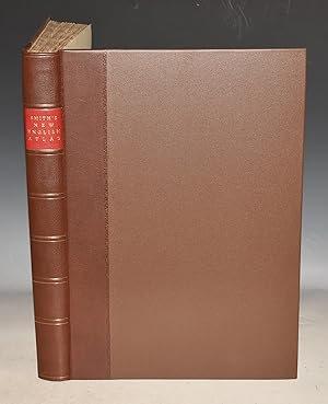
English Atlas Being a Complete Set of County Maps, Divided into Hundreds on which are delineated all the Direct and Cross Roads Part of which are from actual Measurement. Cities, Towns and most considerable Villages, Parks, Gentlemen?s Seats, Rivers and Navigable Canals: Preceded by a General Map of England and Wales on which the principle Roads are carefully described, for the purpose of facilitating the connexion of the respective Maps. The whole accompanied by an Index Villaris, containing upwards of Forty Thousand Names of Places mentioned in the work, with reference to their Situation.
Verlag: Printed for C.Smith, Mapseller. London 1804, 1804
Anbieter: PROCTOR / THE ANTIQUE MAP & BOOKSHOP, DORCHESTER, Vereinigtes Königreich
Verbandsmitglied: PBFA
Verkäuferbewertung 5 von 5 Sternen
EUR 1.639,46
EUR 23,15 Versand
Versand von Vereinigtes Königreich nach USAAnzahl: 1 verfügbar
In den WarenkorbLarge folio. Rebound in Quarter brown leather with decorative tooling spine & raised bands, Unsigned but by Frank Brown, bookbinder of Dorchester, Dorset. New Yellow endpapers. Binding in FINE condition. Inside title page a bit darkened & lightly marked. A number of map edges & corners have been professionally repaired, only effecting margins. One map (Worcester) has small browned hole lower right corner of map. Else generally clean & tight. Size 21.5 x 15.5 inches 42 Maps on 46 Sheets, Original Colouring, Engraved title page, List of contents and 26 sheets of Index to places & list of Subscribers, printed on both sides. Hand coloured Atlas of England and Wales with surprisingly modern looking maps. A good example of the first edition of this atlas of large-scale, detailed county maps of England and Wales. Yorkshire is on four sheets and Wales is shown on two. With index and subscribers list. In spite of outward appearance the maps are clean and clear. Maps Bedfordshire, berkshire, Buckinghamshire, Cambridgeshire, Cheshire, Cornwall, Cumberland, Derbyshire, Devonshire, Dorsetshire, Durham, Essex, Glocestershire, Hampshire, Herfordshire, Hertfordshire, Huntingdonshire, Kent, Lancashire, Leicestershire, Lincolnshire, Middlesex, Monmouthshire, Norfolk, Northamptonshire, Northumberland, Nottinghamshire, Oxfordshire, Rutlandshire, Shropshire, Somersetshire, Staffordshire, Suffolk, Surrey, Sussex, Warwickshire, Westmoreland, Wiltshire, Worcestershire, Yorkshire on 4 sheets, Wales shown on two maps.