Gesamtpreis (1 Artikel Artikel):
Versandziel:

new mexico von rand mcnally (90 Ergebnisse)
Direkt zu den wichtigsten Suchergebnissen
Produktart
- Alle Produktarten
- Bücher (83)
- Magazine & Zeitschriften
- Comics
- Noten
- Kunst, Grafik & Poster (2)
- Fotografien
- Karten (5)
-
Manuskripte &
Papierantiquitäten
Zustand
Einband
Weitere Eigenschaften
- Erstausgabe (2)
- Signiert
- Schutzumschlag
- Angebotsfoto (32)
- Kein Print-on-Demand (89)
Gratisversand
Land des Verkäufers
Verkäuferbewertung
-
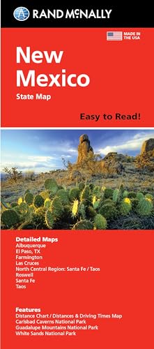
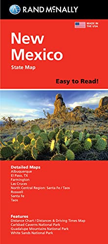
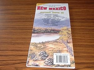
Rand McNally Easy to Read Folded Map: New Mexico State Map
Verlag: Rand McNally (edition ), 2021
ISBN 10: 0528024582ISBN 13: 9780528024580
Buch
Map. Zustand: Very Good. Ship within 24hrs. Satisfaction 100% guaranteed. APO/FPO addresses supported.
-
Easy To Read: New Mexico State Map
Verlag: Rand McNally, 2012
ISBN 10: 0528881876ISBN 13: 9780528881879
Buch
Zustand: Good. Item in good condition. Textbooks may not include supplemental items i.e. CDs, access codes etc.
Mehr Angebote von anderen Verkäufern bei AbeBooks
Neu ab EUR 23,05
Gebraucht ab EUR 8,03
Mehr entdecken Softcover
-
Rand McNally Easy to Read: New Mexico State Map
Verlag: Rand McNally, 2024
ISBN 10: 0528029053ISBN 13: 9780528029059
Buch
Zustand: New.
Mehr Angebote von anderen Verkäufern bei AbeBooks
Neu ab EUR 12,51
-
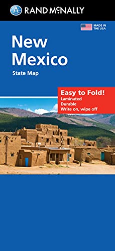
Rand McNally Easy to Fold: New Mexico State Laminated Map (Paperback)
Verlag: Rand McNally, 2024
ISBN 10: 0528028146ISBN 13: 9780528028144
Buch
Paperback. Zustand: new. Paperback. Shipping may be from multiple locations in the US or from the UK, depending on stock availability.
Mehr Angebote von anderen Verkäufern bei AbeBooks
Neu ab EUR 13,54
-
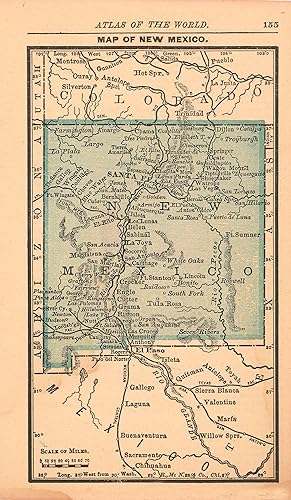
MAP: 'New Mexico'.from Rand McNally's Dollar Atlas of the World
Verlag: Rand McNally & Co., Chicago IL, 1916
Kunst / Grafik / Poster
Unbound. Zustand: Very Good. Colored Map (illustrator). 5.5" x 7'' map, suitable for framing Size: 5.5" x 7''.
-
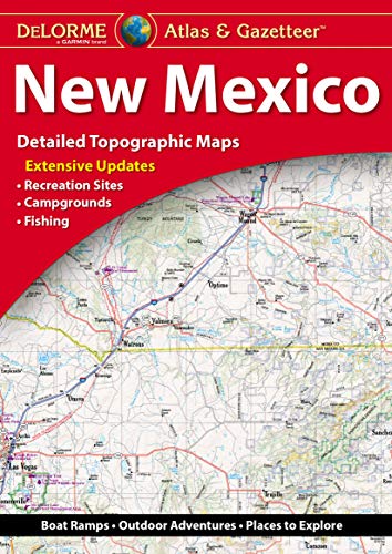
Delorme Atlas & Gazetteer: New Mexico
Verlag: Delorme Mapping Company, 2023
ISBN 10: 1946494666ISBN 13: 9781946494665
Buch
paperback. Zustand: Very Good. Publisher overstock. May have remainder mark / minor shelfwear. 99% of orders arrive in 4-10 days. Discounted shipping on multiple books.
Mehr Angebote von anderen Verkäufern bei AbeBooks
Neu ab EUR 21,61
Gebraucht ab EUR 14,23
Mehr entdecken Softcover
-

Rand McNally Easy To Fold: New Mexico (Laminated Fold Map)
Verlag: Rand McNally, 2012
ISBN 10: 0528998757ISBN 13: 9780528998751
Buch
Zustand: Very Good. Book is in Used-VeryGood condition. Pages and cover are clean and intact. Used items may not include supplementary materials such as CDs or access codes. May show signs of minor shelf wear and contain very limited notes and highlighting.
Mehr Angebote von anderen Verkäufern bei AbeBooks
Neu ab EUR 32,62
Gebraucht ab EUR 19,12
Mehr entdecken Softcover
-
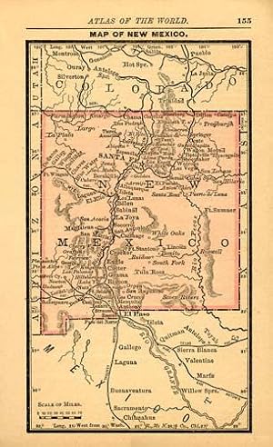
MAP: "Colorado" (New Mexico on reverse).from Atlas of the World
Verlag: Rand McNally & Co, Chicago, IL, 1895
Kunst / Grafik / Poster Erstausgabe
Unbound. Zustand: Very Good. Colored Map (illustrator). 1st. 11" x 14" colored maps; New Mexxico on reverse; either side suitable for framing Size: 11" x 14".
-
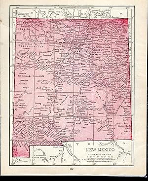
Zustand: Good. New Mexico state map showing counties. RAND MCNALLY 1906 old antique chart. Antique colour (color) atlas map; Rand McNally (1906). 34.0 x 26.5cm, 13.25 x 10.25 inches. Condition: Good. There are images and/or text printed on the reverse side of the picture. In some cases this may be visible on the picture itself or around the margin of the picture.
-

Rand McNally Easy to Fold: New Mexico State Laminated Map
Verlag: Rand McNally, 2021
ISBN 10: 0528024787ISBN 13: 9780528024788
Buch
Zustand: New. Book is in NEW condition.
-
Recreational Map of New Mexico: Full Colour Road Map for Outdoor Enthusiasts (USA city maps - New Mexico)
Verlag: Rand McNally & Co ,U.S., 1992
ISBN 10: 1881262081ISBN 13: 9781881262084
Karte
Soft cover. Zustand: Good. Good fold-out map. Some light creasing and edge wear. --- General information: please email for any more information or condition photos. There may be other minor faults not included here, but this description should include all important points and convey accurately the overall conditon of the book(s). We are happy to give a more detailed description (by volume where applicable) on request. Posted next day (Mon-Fri) from the UK. We normally post by Royal Mail 1st class within the UK, but may use a slower service for books over 1kg or multiple orders or a tracked service for higher value orders. We normally post by Royal Mail Airmail for overseas deliveries, and may request additional postage (at cost) for heavier books or for tracking (buyers always have the option to cancel the order if we do so).
-
![Bild des Verkäufers für Rand McNally & Co.'s indexed pocket map and shippers' guide of Mexico : accompanied by a new and original compilation and ready reference index, showing in detail the entire railroad system, the express company doing business over each road, and accurately locating all states and territories, cities, towns, post offices, railroad stations, villages, islands, lakes, rivers, etc. Volume TEXT (1914) [Leatherbound] zum Verkauf von S N Books World](https://pictures.abebooks.com/inventory/md/md30639188164.jpg)
Rand McNally & Co.'s indexed pocket map and shippers' guide of Mexico : accompanied by a new and original compilation and ready reference index, showing in detail the entire railroad system, the express company doing business over each road, and accurately locating all states and territories, cities, towns, post offices, railroad stations, villages, islands, lakes, rivers, etc. Volume TEXT (1914) [Leatherbound]
Erscheinungsdatum: 2022
Buch Print-on-Demand
Leatherbound. Zustand: NEW. Leatherbound edition. Condition: New. Leather Binding on Spine and Corners with Golden leaf printing on spine. Bound in genuine leather with Satin ribbon page markers and Spine with raised gilt bands. A perfect gift for your loved ones. Reprinted from 1914 edition. NO changes have been made to the original text. This is NOT a retyped or an ocr'd reprint. Illustrations, Index, if any, are included in black and white. Each page is checked manually before printing. As this print on demand book is reprinted from a very old book, there could be some missing or flawed pages, but we always try to make the book as complete as possible. Fold-outs, if any, are not part of the book. If the original book was published in multiple volumes then this reprint is of only one volume, not the whole set. IF YOU WISH TO ORDER PARTICULAR VOLUME OR ALL THE VOLUMES YOU CAN CONTACT US. Resized as per current standards. Sewing binding for longer life, where the book block is actually sewn (smythe sewn/section sewn) with thread before binding which results in a more durable type of binding. Pages: 84 Language: English Volume TEXT Pages: 84 Volume TEXT.
-
With the 19th century innovations of publishing and technology, the world became a smaller place and one which anyone could become acquainted with. As these changes blossomed, the fledgling company of Rand McNally realized the interest in small accessible material, and produced a pocket atlas. These maps carry handy reference information, and were up to date for the period. They include cities, some towns as well as some roads. They have their own charm and would be great for framing, and decorative use. This map measures 5 inches by 3 inches.
-

Rand-McNally indexed pocket map and shippers' guide of New Mexico : railroads, electric lines, post offices, express, telegraph and mail service ; counties, congressional townships, cities, towns, villages, islands, lakes, rivers, creeks, etc. ; population according to the latest official census.
Verlag: Rand McNally and Company., Chicago, New York, 1922
none. Zustand: Very Good. Covers are not present, Booklet and map are seperated.Both in very good condition. Booklet 21 pp. plus advs. Index Map folded.
-
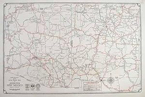
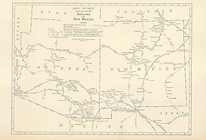
Rand McNally & Company, still a major name in map publishing to this day, began as a small print shop opened in Chicago in 1856 by William H. Rand. The shop originally printed guidebooks and directories. In 1858, Rand hired Andrew McNally who was later to become a partner. Within the next few years, the shop got into the railroad business by starting to print railway tickets and schedules, a key step in the development of the company. The ticket printing led to the publishing of railway guides, and by 1872 Rand McNally and Company had the capacity to publish maps. This map of Arizona and New Mexico came from Rand McNallys Commercial Atlas. A highly successful run of atlases that lasted over a decade. These maps were primarily used by business, because of their accurate listing of railroads in operation as well as tables of statistical information. This map is unique in several ways, their large format makes an impressive display, and offers additional room where many small towns and extra details are included. Additionally a list of every railroad operating in the state in 1932 is included. All railroad routes are shown on the map. This map includes all cities and towns, lakes, rivers, and bodies of water. All topographical features are also included as well as political features such as counties and Native American Indian reservations. This map measures 11 inches by 17 inches.
-
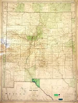
The 1936, sixty-seventh edition of the "Rand McNally Commercial Atlas and Marketing Guide" is unique in its inclusion of informative details concerning population sizes, district uses, the size of counties, and railroad routes. Cities and their populations are listed beside the map. Each map is brightly colored; predominantly in green with blue oceans, lakes and rivers, and brown coloring of high density metropolitan areas. New Mexico is illustrated on this large, double page map. The names of cities, counties, lakes, and rivers are labeled. This map measures 25.5 inches by 19 inches.
-

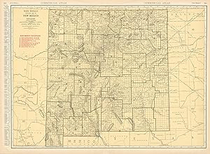
Rand McNally & Company, still a major name in map publishing to this day, began as a small print shop opened in Chicago in 1856 by William H. Rand. The shop originally printed guidebooks and directories. In 1858, Rand hired Andrew McNally who was later to become a partner. Within the next few years, the shop got into the railroad business by starting to print railway tickets and schedules, a key step in the development of the company. The ticket printing led to the publishing of railway guides, and by 1872 Rand McNally and Company had the capacity to publish maps. This map of New Mexico came from Rand McNallys Commercial Atlas. A highly successful run of atlases that lasted over a decade. These maps were primarily used by business, because of their accurate listing of railroads in operation as well as tables of statistical information. This map measures 19 inches by 26 inches.
-
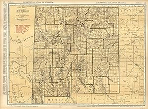
Rand McNally & Company, still a major name in map publishing to this day, began as a small print shop opened in Chicago in 1856 by William H. Rand. The shop originally printed guidebooks and directories. In 1858, Rand hired Andrew McNally who was later to become a partner. Within the next few years, the shop got into the railroad business by starting to print railway tickets and schedules, a key step in the development of the company. The ticket printing led to the publishing of railway guides, and by 1872 Rand McNally and Company had the capacity to publish maps. This map of New Mexico came from Rand McNally's Commercial Atlas, sixty-first Edition dated 1930. A highly successful run of atlases that lasted over a decade. These maps were primarily used by business, because of their accurate listing of railroads in operation as well as tables of statistical information. This map is unique in several ways, their large format makes an impressive display, and offers additional room where many small towns and extra details are included. Additionally a list of every railroad operating in the state in 1930 is included. All railroad routes are shown on the map. This map includes all cities and towns, lakes, rivers, and bodies of water. All topographical features are also included as well as political features such as counties and Native American Indian reservations. This map measures 19 inches by 26 inches.
-

Map New Mexico
Verlag: Rand McNally & Company
ISBN 10: 0528273728ISBN 13: 9780528273728
Anbieter: Wonder Book, Frederick, MD, USA
Bewertung:

Buch
Zustand: Good. Good condition. A copy that has been read but remains intact. May contain markings such as bookplates, stamps, limited notes and highlighting, or a few light stains.
-
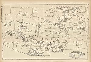
This map of Arizona and New Mexico was produced by Rand McNally and Co. as part of its Commercial Atlas of America. The detail shown on each map is exceptional because of the map size. These maps were intended to be used by business for shipping, etc. Roads, railroads, and rivers are clearly shown. There is more detail on these maps than any others during this time period.The size of the map is 19 x 12.5.
-
This map of New Mexico was produced by Rand McNally and Co. as part of its Commercial Atlas of America. The detail shown on each map is exceptional because of the map size. These maps were intended to be used by business for shipping, etc. Roads, railroads, and rivers are clearly shown. There is more detail on these maps than any others during this time period. This map measures 19 inches by 25.5 inches.
-
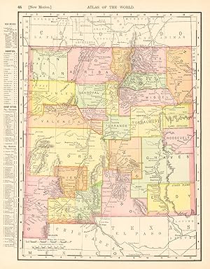
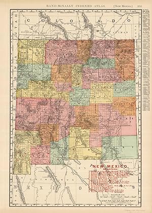
This large format map was published in Rand McNally & Co.s Indexed Atlas of the World, dated 1908. This detailed state map shows, cities and towns, counties, lakes and rivers, and Post Offices. Unique to this map is the information provided on the existing railroad network at the time. Each railroad is shown, along with scheduled stops, and included are a list of the rails roads and the railroad owner. Map also provides capitals, county seats, scale of miles, and a detailed list of towns down the side noting population. A neat glimpse of the nation in the early 20th century. This map measures 19 inches by 12.5 inches.
-
This map was produced by Rand McNally and Co. as part of its 1928 Commercial Atlas of America. These maps are some of our favorite maps because of the large size of each map sheet. The detail shown on each map is exceptional because of the map size. These maps were intended to be used by business for shipping and other uses. Roads, railroads, rivers, and buildings are clearly shown. There is more detail on these maps than any others during this time period. This map measures 20.5 inches by 28 inches.
-
This map was produced by Rand McNally and Co. as part of its 1928 Commercial Atlas of America. These maps are some of our favorite maps because of the large size of each map sheet. The detail shown on each map is exceptional because of the map size. These maps were intended to be used by business for shipping and other uses. Roads, railroads, rivers, and buildings are clearly shown. There is more detail on these maps than any others during this time period. This map measures 8.25 inches by 11 inches.
-
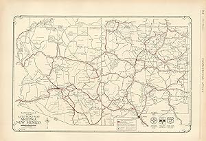
This map was produced by Rand McNally and Co. as part of its 1928 Commercial Atlas of America. These maps are some of our favorite maps because of the large size of each map sheet. The detail shown on each map is exceptional because of the map size. These maps were intended to be used by business for shipping and other uses. Roads, railroads, rivers, and buildings are clearly shown. There is more detail on these maps than any others during this time period. Without a doubt Rand McNally and Co. did the best job showing individual state maps dedicated to auto roads. This map measures 14 inches by 20.5 inches.
-
This map of New Mexico was produced by Rand McNally and Co. as part of its Commercial Atlas of America. These maps are some of our favorite maps because of the large size of each map sheet (25.5â x20.5â ). The detail shown on each map is exceptional because of the map size. These maps were intended to be used by business for shipping and other uses. Roads, railroads, and rivers are clearly shown. There is more detail on these maps than any others during this time period. This map measures 19 inches by 25.5 inches.
-
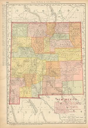
We are proud to offer this wonderful large scale map originally issues as part of Rand, McNally's Enlarged Business Atlas and Shippers Guide, Showing in Detail the Entire Railroad System in 1902. The maps from this atlas were larger than most atlas' published at the time and show many more cities and towns. All railroad lines were drawn in red and numbered with a listing of all railroads operating in the state on each map. William H. Rand founded the company in 1856 and incorporated it in 1873 with his partner Andrew McNally. They published their first atlas, The Business Atlas, in 1877. Rand McNally and Company is the oldest business of its kind in the country. This map measures 19.5 inches by 13.25 inches.
-
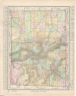
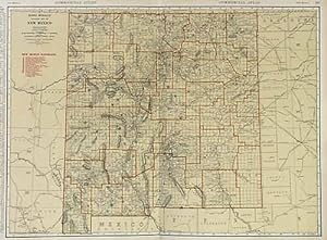
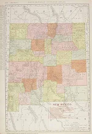
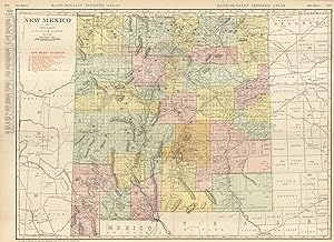
This large scale map came from the 1905 Rand-McNally Indexed Atlas. This multi-colored map of New Mexico shows railroads, roads, counties, cities, towns, Indian reservations and many topographical features. All railroads operating in 1905 are shown on this map, including a detailed list of the railroads in red. Numerous small towns are shown, many of which have now become ghost towns. The back side of the map contains a referenced list of cities and their locations. This map is in very good condition and contains fantastic detailing. This map measures 19 inches by 13 inches.
-
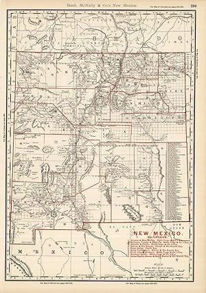
This map is from the 1895 "Rand McNally & Co.s Enlarged Business Atlas and Shipper's Guide, containing large scale maps of all states and territories in the United States, the Dominion of Canada, the Republic of Mexico, Central America, the West Indies, and Cuba, showing in detail the entire railroad system, the different railroads being distinguished by different figures, accompanied by a new and original compilation and ready reference index, giving the express company doing business over each road, and accurately locating all islands, lakes, rivers, mountains, counties, parishes, cities, towns, post offices, railroad stations, villages, etc, together with complete reference maps of all countries, printed from type-lettered plates, producing the clearest typographical effect of any known engraved plates, also guide maps showing the streets, transportation lines, and public buildings of the large cities in the United States". This map measures 19 inches by 13 inches.