Gesamtpreis (1 Artikel Artikel):
Versandziel:

novissima totius terrarum orbis tabula, visscher (2 Ergebnisse)
Direkt zu den wichtigsten Suchergebnissen
Produktart
- Alle Produktarten
- Bücher (2)
- Magazine & Zeitschriften
- Comics
- Noten
- Kunst, Grafik & Poster
- Fotografien
- Karten
-
Manuskripte &
Papierantiquitäten
Zustand
- Alle
- Neu
- Antiquarisch/Gebraucht
Einband
- alle Einbände
- Hardcover
- Softcover
Weitere Eigenschaften
- Erstausgabe
- Signiert
- Schutzumschlag
- Angebotsfoto (1)
- Kein Print-on-Demand
Land des Verkäufers
Verkäuferbewertung
-
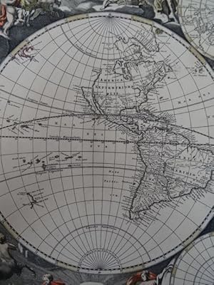
Novissima totius terrarum orbis tabula. Altkolorierte Original-Kupferstichkarte von Nicolaas Visscher. Amsterdam, ca. 1679. 42,5 x 52,5 cm.
Erscheinungsdatum: 1679
Anbieter: Antiquariat Daniel Schramm e.K., Kiel, Deutschland
Bewertung:

Zustand: 0. Prächtige, zart altkolorierte Weltkarte, teils mit winzigen Haarrissen am Altkolorit.- Shirley 486: 'It is not certain when this further world map by Nicolaas Visscher first appeared. It may well have been produced by Nicolaas Visscher II following the death of his father Nicolaas Visscher I in 1679 and this date has been suggested by Koeman.' Sprache: Deutsch Gewicht in Gramm: 500.
-

Single sheet (22 Ľ x 19 ˝) Full margins showing the plate mark. (Very light foxing along margin). An exquisite double hemisphere map by Nicolaes Visscher; taken from the Atlas Minor c. 1690. This map is in near excellent condition, with stunning hand-coloring to emphasize and enhance the gorgeous map. The map was exquisitely exhibits an expert hand-coloring, with preserved light gold detailing, in the style of the celebrated Dutch colorist Dirk Jansz. The most distinctive attractiveness and trait found in many 17th century maps is in their border decorating the maps. Visscher s is absolutely no exception. His artist chose elaborate illustrated scenes featuring various signs of the zodiac, accompanied by cherubs and other heavenly figures. This map is based off of Visscher s first original double hemisphere world map from c.1658. It is considered the forerunner and master example of the numerous Dutch world maps produced during this half of the 16th century. Although it was influenced by Blaeu s 1648 world map, Visscher made no true geographical changes to the European sector. His true innovation lies in his rendering of the New World, where he added small variations to the still widely unknown North American coastline. Visscher's map also includes a set of smaller polar hemispheric projections at the top and bottom of the map. The map we present you with today is a spectacular later edition of this same map. Examples of this map in Visscher atlases usually date back to 1680; however, the inscription "cum privilegio: ordin: geenrak: Belgii Foederati" printed below the map title, suggests it appeared in Van Keulen s atlas, dating from 1690-95. The Atlas Minor is a fine and comprehensive composite atlas, and one of a series of large atlases compiled and sold by the Visscher family of art dealers and cartographers in the 17th century. Founded by Nicholas Visscher, this work is known for the high quality of engraving, exceptionally fine ornament, and accurate geographical information. No two of the Visscher atlases seem to have been identical in content, and most contain, like this one, a selection of maps by the Visschers themselves as well as other cartographers. In this case the majority of the maps are published by Visscher. In addition to the striking world map by Allard with its black background and numerous projections, and found in the "Atlas Major" from about 1705, there are maps of the continents, regional maps of Europe, ten maps of Asia, and seven maps related to America. For more information on this map, or a warm welcome to see other maps and books of our collection at 72nd Street NYC, please contact Natalie Zadrozna.