Gesamtpreis (1 Artikel Artikel):
Versandziel:

official use only field notes (5 Ergebnisse)
Direkt zu den wichtigsten Suchergebnissen
Suchfilter
Produktart
- Alle Product Types
- Bücher (5)
- Magazine & Zeitschriften (Keine weiteren Ergebnisse entsprechen dieser Verfeinerung)
- Comics (Keine weiteren Ergebnisse entsprechen dieser Verfeinerung)
- Noten (Keine weiteren Ergebnisse entsprechen dieser Verfeinerung)
- Kunst, Grafik & Poster (Keine weiteren Ergebnisse entsprechen dieser Verfeinerung)
- Fotografien (Keine weiteren Ergebnisse entsprechen dieser Verfeinerung)
- Karten (Keine weiteren Ergebnisse entsprechen dieser Verfeinerung)
- Manuskripte & Papierantiquitäten (Keine weiteren Ergebnisse entsprechen dieser Verfeinerung)
Zustand Mehr dazu
- Neu (Keine weiteren Ergebnisse entsprechen dieser Verfeinerung)
- Wie Neu, Sehr Gut oder Gut Bis Sehr Gut (Keine weiteren Ergebnisse entsprechen dieser Verfeinerung)
- Gut oder Befriedigend (2)
- Ausreichend oder Schlecht (Keine weiteren Ergebnisse entsprechen dieser Verfeinerung)
- Wie beschrieben (3)
Einband
- alle Einbände
- Hardcover (4)
- Softcover (Keine weiteren Ergebnisse entsprechen dieser Verfeinerung)
Weitere Eigenschaften
- Erstausgabe (2)
- Signiert (Keine weiteren Ergebnisse entsprechen dieser Verfeinerung)
- Schutzumschlag (Keine weiteren Ergebnisse entsprechen dieser Verfeinerung)
- Angebotsfoto (5)
- Keine Print-on-Demand Angebote (5)
Sprache (2)
Preis
- Beliebiger Preis
- Weniger als EUR 20 (Keine weiteren Ergebnisse entsprechen dieser Verfeinerung)
- EUR 20 bis EUR 45 (Keine weiteren Ergebnisse entsprechen dieser Verfeinerung)
- Mehr als EUR 45
Gratisversand
- Kostenloser Versand nach USA (Keine weiteren Ergebnisse entsprechen dieser Verfeinerung)
Land des Verkäufers
Verkäuferbewertung
-
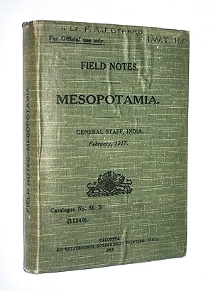
Field Notes Mesopotamia February 1917 (Catalogue No. M.3 (11349) For Official Use Only)
Sprache: Englisch
Verlag: Superintendent Government Printing, India, Calcutta, 1917
Anbieter: Dendera, London, Vereinigtes Königreich
Verkäuferbewertung 5 von 5 Sternen

EUR 1.791,91
EUR 29,00 Versand
Versand von Vereinigtes Königreich nach USAAnzahl: 1 verfügbar
In den WarenkorbHardcover. Zustand: Very Good. Black printed green cloth with flap 14x19cm. (2), 326pp including 3 folding leaves (containing pp274-9), (1)pp, with the Survey of India's colour folding "Lower Mesopotamia" map loose in the front pocket. The separately issued Index booklet is not present. The previous owner has inscribed his details to the front cover, ffep and map verso (Lieutenant F.R.J. Gerard, IWT, RE dated Mespot / 1917). Covers otherwise very good with bubbling to cloth and wear to spine ends, interiors mostly near fine with two archival tape reinforcements to the front hinges, pencil notes to ffep, colour pencil underlines and sidelines to some pages. The map is neatly folded with some marks and closed tears. Frank R.J. Gerard was at this time with Inland Waterways Transport, Royal Engineers. After WW1 he went into business and became an active Theosophist associated with Annie Besant, Charles Webster Leadbetter among others. Often referred to as the 2nd edition (1917), this would technically be the 3rd edition, after those of 1914 and 1915. While predominantly focused on Mesopotamia, it also covers key personalities and events relating to Kuwait, Arabistan, Najd, Al Hasa, Luristan, and elsewhere, including the activities and strength of the Ottoman armed forces, as they impact on Mesopotamia and British interests. Chapters cover History, Geography, Population, Resources, Notes on the Turkish Army, Maritime, and Administration, Communications, and Routes in Mesopotamia (increased to 36 from previous editions). Appendices include Important personages (summaries of their backgrounds, ambitions, and relations with Britain); Distances; Weights, measures, currency, chronology; Notes for Officers proceeding to Mesopotamia (with several of Gerard's underlines and ticks); Glossary; and Index.
-
Field Notes on Lower Mesopotamia - October 1914 (For Official Use Only - Catalogue No. M-2-F.O.U.O.)
Sprache: Englisch
Verlag: Printed at the Government Monotype Press, Simla, 1914
Anbieter: Dendera, London, Vereinigtes Königreich
Verkäuferbewertung 5 von 5 Sternen
EUR 7.764,94
EUR 29,00 Versand
Versand von Vereinigtes Königreich nach USAAnzahl: 1 verfügbar
In den WarenkorbHardcover. Zustand: Very Good. Printed buff cloth with flap, a pocket inside the upper and band inside lower board. v + 85pp + unindexed folding map of Lower Mesopotamia in pocket (1914, heliozincographed at the Survey of India Offices, Dehra Dun, 50x50cm, 1 inch = 32 miles). Covers very good, lightly dusted. Interiors fine. The second part of the sentence "There are many creeks and some marshes, and Abbadan Island is not suitable for the movement of troops" (p6) has been redacted in blue pencil but is still legible (this appears to have been done by the General Staff, as the BL/QDL copy has the same redaction in red pencil). The map is neatly folded with a couple of closed tears. This copy belonged to W. Kenny, X-Rays Operator, RAMC, Military Hospital, Nasiryeh, Iraq, who is named to the ffep and map verso. This looks to be extremely rare, with Worldcat and Jisc recording only the 1915 and 1917 editions (titled "Field Notes Mesopotamia", generally referred to as the first and second editions). Qatar National Library has digitised a copy from British Library India Office Records, which appears to be without the map. This was printed on 6 Oct 1914, in the month before Britain declared war on Turkey and occupied Basra. It is one of the earliest major intelligence documents of the area, prepared to inform operations relating to the Ottomans, regional powers, and local tribes. It builds on findings from the expedition of 1856-7. Thus Chapter I outlines "how a British expedition was sent to Persia to force the Persians to desist from attacking Herat", resulting in "the enemy being worn out and half starved owing to their hasty retreat". Other chapters cover geography (Shatt al Arab, Bahanshir and Karun Rivers, north of Basra, Basra, Zubair, Muhammareh); population; resources (water, supplies, transport, trade); military (nominal and actual war strengths, efficiency, Turkish reinforcements, land defences at various locations, fighting qualities of Arabs, Kuwait forces, camping grounds); maritime (Turkish naval strength, landing facilities at various locations); administration (Basrah, Arabistan, Kuwait, foreign interests), and communications (lines of advance, routes, telegraphs, telephones). Appendices include Notes on Qatar and Doha; Important Personages (Persian royals, Arab Sheikhs, advisors, senior Ottoman personnel); and a glossary. The language is very much to the point, sometimes almost in note form, giving fascinating insights into character, ruling styles etc, and how these might be turned to advantage. Eg the Shaikh of Kuwait's rule "is despotic, personal and absolute. The heads of his departments are mostly slaves. There is no delegation of authority" (p63). Qatar has "a rich and powerful chief" and although he flies the Turkish flag "dislikes his rulers and would be glad to be rid of them" (p79). The Deputy for Basrah is "strong, wilful, utterly unscrupulous, usually in debt. Holds Basrah in the palm of his hand by means of a band of armed men. Has about a dozen murders to his credit". Exploitable divisions and weaknesses are highlighted based on fact, eg, the Chief of the Bani Lam is "lately (1914) engaged in hostilities with the Shaikh of Muhammareh", or on hearsay, eg, Brigadier Hissam ud-Din is "said not to be on good terms with the Vali" of Baghdad. There is also indication of people that might be worked with. Eg, the Vali of Baghdad is strong, energetic and intent on reforms. And there is of course great respect for Ibn Saud, who "stands head and shoulders above other Arab chiefs, and they have implicit faith in him", has approached British political officers on more than one occasion to seek alliance against the Turks, and could raise 5-7000 well armed fighting men (pp82-83).
-
For official use only. Field Notes. Mesopotamia. General staff, India. February 1917. Including: Index to field notes, Mesopotamia, 1917.
Verlag: Calcutta, Superintendent Government Printing, India, 1917., 1917
Anbieter: Antiquariat INLIBRIS Gilhofer Nfg. GmbH, Vienna, A, Österreich
Verbandsmitglied: ILAB VDA VDAO
Verkäuferbewertung 5 von 5 Sternen
Erstausgabe
Small 8vo (175 x 135 mm). [4], 326 (pp. 272f. printed on a single page, pp. 274-279 printed as three folding tables), [1] pp. With large folding map and additional separately printed index in pocket at front. Original green cloth, printed title to spine and upper flap. Ownership inscription of H. W. Leatham, Lieut., RAMC, dated April, 1918. First edition of a field guide to Mesopotamia (Iraq), published on behalf of the General Staff in India for the use of officers serving in the Mesopotamian campaign during the First World War, stating on the binding and title-page "for official use only". The guide is divided into eight chapters, dealing with Iraq's history, geography, population, resources, military strength, maritime power, administration and communication respectively. The fifth and sixth chapter also contain valuable information on the Turkish military and maritime strength. Added to the present guide is many newly acquired information not present in the 1915 guide. For example, the "list of routes" in the present guide contains 36 routes from one city to another, compared to 14 routes in the 1915 guide. The routes are shown on the folding map. With the owner's inscription of H. W. Leatham, Lieutenant in the British Royal Army Medical Corps, on the first flyleaf. A few small spots or stains. Binding only very slightly rubbed. Overall in very good condition.
-
For official use only. Field notes. Mesopotamia. General staff, India. February 1917.Including: Index to field notes, Mesopotamia, 1917.
Verlag: Superintended government printing,, Calcutta,, 1917
Anbieter: Antiquariaat FORUM BV, Houten, Niederlande
Verkäuferbewertung 5 von 5 Sternen
EUR 6.500,00
EUR 25,00 Versand
Versand von Niederlande nach USAAnzahl: 1 verfügbar
In den WarenkorbSecond edition, considerably expanded, of a field guide to Mesopotamia (Iraq), published on behalf of the General Staff in India for the use of officers serving in the Mesopotamian campaign during the First World War, stating on the binding and title-page "for official use only". The guide is divided into eight chapters, dealing with Iraq's history, geography, population, resources, military strength, maritime power, administration and communication respectively. The fifth and sixth chapter also contain valuable information on the Turkish military and maritime strength. The present edition adds much new information that was not included in the 1915 edition. For example, the "list of routes" in the present guide contains 36 routes between, compared to 14 routes in the 1915 guide. The routes are shown on the folding map.With the owner's inscription of H.W. Leatham, Lieutenant in the British Royal Army Medical Corps, on the first flyleaf. A few small spots or stains. Binding only very slightly rubbed. Overall in very good condition. Original green cloth, with title on spine and front. With 1 folding heliozincographed map of "Lower Mesopotamia" (map size 41 x 37 cm), with some routes in red, and three folding letterpress tables. Pages: [3], [1], 326(=325), [1]; [1], [1 blank], XX pp.
-
Field Notes on British East Africa. General Staff, India. Cat. No. A-68. For Official Use Only.
Verlag: Simla: Printed at the Government Monotype Press, 1914, 1914
Anbieter: Peter Harrington. ABA/ ILAB., London, Vereinigtes Königreich
Verbandsmitglied: ABA ILAB PBFA
Verkäuferbewertung 5 von 5 Sternen
Erstausgabe
EUR 1.493,26
EUR 25,52 Versand
Versand von Vereinigtes Königreich nach USAAnzahl: 1 verfügbar
In den WarenkorbFirst edition, otherwise untraced and one of 300 copies only. This intelligence guide was prepared for the recently formed Indian Expeditionary Force B in advance of its disastrous attack on German East Africa. It served as a forerunner to Meinertzhagen's more extensive Intelligence Notes on British & German East Africa (1915 and 1916). After an opening section on the Omani sultanate, chapters cover geography, climate, population, resources, military affairs, and land and maritime communications. Provenance: Humphrey Winterton, the major travel collector, number 549 in Maggs Catalogue 1343, From the Abyssinian Expedition to the Mau Mau Insurrection: The African Library of Humphrey Winterton (2003). Duodecimo. Original light blue card wrappers, front cover printed in black. Housed in black quarter morocco custom box. Wrappers marked and creased, wire stitching rusting, making a few leaves loose,