Gesamtpreis (1 Artikel Artikel):
Versandziel:

planisphĶre colonies ķtablissements franńais 1870 von pollacchi (3 Ergebnisse)
Direkt zu den wichtigsten Suchergebnissen
Suchfilter
Produktart
- Alle Product Types
- B³cher (Keine weiteren Ergebnisse entsprechen dieser Verfeinerung)
- Magazine & Zeitschriften (Keine weiteren Ergebnisse entsprechen dieser Verfeinerung)
- Comics (Keine weiteren Ergebnisse entsprechen dieser Verfeinerung)
- Noten (Keine weiteren Ergebnisse entsprechen dieser Verfeinerung)
- Kunst, Grafik & Poster (Keine weiteren Ergebnisse entsprechen dieser Verfeinerung)
- Fotografien (Keine weiteren Ergebnisse entsprechen dieser Verfeinerung)
- Karten (3)
- Manuskripte & Papierantiquitõten (Keine weiteren Ergebnisse entsprechen dieser Verfeinerung)
Zustand Mehr dazu
- Neu (Keine weiteren Ergebnisse entsprechen dieser Verfeinerung)
- Wie Neu, Sehr Gut oder Gut Bis Sehr Gut (Keine weiteren Ergebnisse entsprechen dieser Verfeinerung)
- Gut oder Befriedigend (3)
- Ausreichend oder Schlecht (Keine weiteren Ergebnisse entsprechen dieser Verfeinerung)
- Wie beschrieben (Keine weiteren Ergebnisse entsprechen dieser Verfeinerung)
Einband
- alle Einbõnde
- Hardcover (Keine weiteren Ergebnisse entsprechen dieser Verfeinerung)
- Softcover (Keine weiteren Ergebnisse entsprechen dieser Verfeinerung)
Weitere Eigenschaften
- Erstausgabe (Keine weiteren Ergebnisse entsprechen dieser Verfeinerung)
- Signiert (Keine weiteren Ergebnisse entsprechen dieser Verfeinerung)
- Schutzumschlag (Keine weiteren Ergebnisse entsprechen dieser Verfeinerung)
- Angebotsfoto (3)
- Keine Print-on-Demand Angebote (3)
Sprache (1)
Preis
- Beliebiger Preis
- Weniger als EUR 20 (Keine weiteren Ergebnisse entsprechen dieser Verfeinerung)
- EUR 20 bis EUR 45
- Mehr als EUR 45 (Keine weiteren Ergebnisse entsprechen dieser Verfeinerung)
Gratisversand
- Kostenloser Versand nach USA (Keine weiteren Ergebnisse entsprechen dieser Verfeinerung)
Land des Verkõufers
Verkõuferbewertung
-
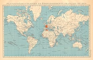
PlanisphĶre - Colonies et ķtablissements Franńais en 1870
Erscheinungsdatum: 1931
Anbieter: Antiqua Print Gallery, London, Vereinigtes K÷nigreich
Verkõuferbewertung 3 von 5 Sternen

Karte
EUR 23,47
EUR 11,39 f³r den Versand von Vereinigtes K÷nigreich nach USAAnzahl: 2 verf³gbar
In den WarenkorbZustand: Good. FRENCH COLONIES & ķtablissements Franńais en 1870. Planisphere 1931 old map. Vintage atlas map; Commandant P. Pollacchi (1931). 23.5 x 36.0cm, 9.25 x 14.25 inches. Condition: Good. The image shown may have been taken from a different example of this map than that which is offered for sale. The map you will receive is in good condition but there may be minor variations in the condition from that shown in the image. There is nothing printed on the reverse side, which is plain.
-

PlanisphĶre - Colonies et ķtablissements Franńais en 1870
Erscheinungsdatum: 1929
Anbieter: Antiqua Print Gallery, London, Vereinigtes K÷nigreich
Verkõuferbewertung 3 von 5 Sternen
Karte
EUR 24,64
EUR 11,39 f³r den Versand von Vereinigtes K÷nigreich nach USAAnzahl: 3 verf³gbar
In den WarenkorbZustand: Good. FRENCH COLONIES & ķtablissements Franńais en 1870. Planisphere 1929 old map. Vintage atlas map; Commandant P. Pollacchi (1929). 23.5 x 36.0cm, 9.25 x 14.25 inches. Condition: Good. The image shown may have been taken from a different example of this map than that which is offered for sale. The map you will receive is in good condition but there may be minor variations in the condition from that shown in the image. There is nothing printed on the reverse side, which is plain.
-
Planisphere - Colonies et ķtablissements Franńais en 1870
Erscheinungsdatum: 1938
Anbieter: Antiqua Print Gallery, London, Vereinigtes K÷nigreich
Verkõuferbewertung 3 von 5 Sternen
Karte
EUR 24,64
EUR 11,39 f³r den Versand von Vereinigtes K÷nigreich nach USAAnzahl: 1 verf³gbar
In den WarenkorbZustand: Good. FRENCH COLONIES & ķtablissements Franńais en 1870. Planisphere 1938 old map. Vintage atlas map; Commandant P. Pollacchi (1938). 23.5 x 36.0cm, 9.25 x 14 inches. Condition: Good. The image shown may have been taken from a different example of this map than that which is offered for sale. The map you will receive is in good condition but there may be minor variations in the condition from that shown in the image. There is nothing printed on the reverse side, which is plain.