Gesamtpreis (1 Artikel Artikel):
Versandziel:

remote british islands isles guernsey von thomson john (3 Ergebnisse)
Direkt zu den wichtigsten Suchergebnissen
Suchfilter
Produktart
- Alle Product Types
- B³cher (Keine weiteren Ergebnisse entsprechen dieser Verfeinerung)
- Magazine & Zeitschriften (Keine weiteren Ergebnisse entsprechen dieser Verfeinerung)
- Comics (Keine weiteren Ergebnisse entsprechen dieser Verfeinerung)
- Noten (Keine weiteren Ergebnisse entsprechen dieser Verfeinerung)
- Kunst, Grafik & Poster (Keine weiteren Ergebnisse entsprechen dieser Verfeinerung)
- Fotografien (Keine weiteren Ergebnisse entsprechen dieser Verfeinerung)
- Karten (3)
- Manuskripte & Papierantiquitõten (Keine weiteren Ergebnisse entsprechen dieser Verfeinerung)
Zustand Mehr dazu
- Neu (Keine weiteren Ergebnisse entsprechen dieser Verfeinerung)
- Wie Neu, Sehr Gut oder Gut Bis Sehr Gut (Keine weiteren Ergebnisse entsprechen dieser Verfeinerung)
- Gut oder Befriedigend (3)
- Ausreichend oder Schlecht (Keine weiteren Ergebnisse entsprechen dieser Verfeinerung)
- Wie beschrieben (Keine weiteren Ergebnisse entsprechen dieser Verfeinerung)
Einband
- alle Einbõnde
- Hardcover (Keine weiteren Ergebnisse entsprechen dieser Verfeinerung)
- Softcover (Keine weiteren Ergebnisse entsprechen dieser Verfeinerung)
Weitere Eigenschaften
- Erstausgabe (Keine weiteren Ergebnisse entsprechen dieser Verfeinerung)
- Signiert (Keine weiteren Ergebnisse entsprechen dieser Verfeinerung)
- Schutzumschlag (Keine weiteren Ergebnisse entsprechen dieser Verfeinerung)
- Angebotsfoto (3)
- Keine Print-on-Demand Angebote (3)
Sprache (1)
Preis
- Beliebiger Preis
- Weniger als EUR 20 (Keine weiteren Ergebnisse entsprechen dieser Verfeinerung)
- EUR 20 bis EUR 45 (Keine weiteren Ergebnisse entsprechen dieser Verfeinerung)
- Mehr als EUR 45
Gratisversand
- Kostenloser Versand nach USA (Keine weiteren Ergebnisse entsprechen dieser Verfeinerung)
Land des Verkõufers
Verkõuferbewertung
-
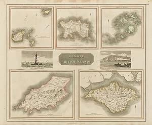
Remote British Islands. Isles of Guernsey, Herm, Sark and Alderney. Isle of Jersey. Isles of Scilly. Isle of Mann. Isle of Wight.
Erscheinungsdatum: 1830
Anbieter: Antiqua Print Gallery, London, Vereinigtes K÷nigreich
Verkõuferbewertung 4 von 5 Sternen

Karte
EUR 99,71
EUR 11,39 shipping
Versand von Vereinigtes K÷nigreich nach USAAnzahl: 1 verf³gbar
In den WarenkorbZustand: Good. "Remote British Islands" Channel & Scilly Isles of Man & Wight. THOMSON 1830 map. Antique early 19th century atlas map with original hand colouring; Drawn & engraved by Nathaniel Robert Hewitt for John Thomson's "New General Atlas" (1830). 52.5 x 63.0cm, 20.5 x 24.75 inches; this is a folding map. Condition: Good. There is nothing printed on the reverse side, which is plain.
-
Remote British Islands. Isles of Guernsey, Herm, Sark and Alderney. Isle of Jersey. Isles of Scilly. Isle of Mann. Isle of Wight.
Erscheinungsdatum: 1817
Anbieter: Antiqua Print Gallery, London, Vereinigtes K÷nigreich
Verkõuferbewertung 4 von 5 Sternen
Karte
EUR 117,31
EUR 11,39 shipping
Versand von Vereinigtes K÷nigreich nach USAAnzahl: 1 verf³gbar
In den WarenkorbZustand: Good. "Remote British Islands" Channel & Scilly Isles of Wight & Man. THOMSON 1817 map. Antique early 19th century atlas map with original hand colouring; Drawn & engraved by Nathaniel Robert Hewitt for John Thomson's "New General Atlas" (Published in 1817. Engraved on 1st January 1817; this date is marked on the map). 53.5 x 65.0cm, 21 x 25.5 inches; this is a folding map. Condition: Good. There is nothing printed on the reverse side, which is plain.
-
Remote British Islands. Isles of Guernsey, Herm, Sark and Alderney. Isle of Jersey. Isles of Scilly. Isle of Mann. Isle of Wight.
Erscheinungsdatum: 1817
Anbieter: Antiqua Print Gallery, London, Vereinigtes K÷nigreich
Verkõuferbewertung 4 von 5 Sternen
Karte
EUR 117,31
EUR 11,39 shipping
Versand von Vereinigtes K÷nigreich nach USAAnzahl: 1 verf³gbar
In den WarenkorbZustand: Good. "Remote British Islands" Channel & Scilly Isles of Man & Wight. THOMSON 1817 map. Antique early 19th century atlas map with original hand colouring; Drawn & engraved by Nathaniel Robert Hewitt for John Thomson's "New General Atlas" (Published in 1817. Engraved on 1st January 1817; this date is marked on the map). 53.5 x 65.0cm, 21 x 25.5 inches; this is a folding map. Condition: Good. Spotting in top margin. There is nothing printed on the reverse side, which is plain.