
Gesamtpreis (1 Artikel Artikel):
Versandziel:

spotsylvania county atlas (2 Ergebnisse)
Direkt zu den wichtigsten Suchergebnissen
Produktart
- Alle Produktarten
- Bücher (2)
- Magazine & Zeitschriften
- Comics
- Noten
- Kunst, Grafik & Poster
- Fotografien
- Karten
-
Manuskripte &
Papierantiquitäten
Zustand
- Alle
- Neu
- Antiquarisch/Gebraucht
Einband
- alle Einbände
- Hardcover
- Softcover (1)
Weitere Eigenschaften
- Erstausgabe
- Signiert
- Schutzumschlag
- Angebotsfoto (1)
- Kein Print-on-Demand
Land des Verkäufers
Verkäuferbewertung
-
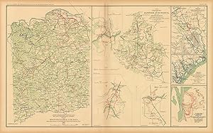
Civil War Atlas; Plate 91; Map of Spotsylvania County; Hanover Junction, Va.; Goldsborough
Erscheinungsdatum: 1893
This plate came from The Atlas to Accompany the Official Records of the Union and Confederate Armies. The Atlas was published between 1891 and 1895 and is the definitive source of Civil War information available. This Plate contains the following map(s). Plate XCI1. Chief Engineers Office D.N.V. Map of Spotsylvania County;2. The Vicinity of Hanover Junction, VA. And its Defenses Campbell;3. Sketch Route Pursued in the Advance to Goldsborough, N.C.;4. Sketch Showing Position of Boyd's Neck, Honey Hill, Devaux's Neck, S.C.;5. Sketch of Spanish Fort Defenses Made During the Siege' This map measures 16.5 inches by 27 inches.
-

Spotsylvania County, Va Atlas
Verlag: Adc the Map People
ISBN 10: 0875300219ISBN 13: 9780875300214
Buch
paperback. Zustand: Very Good. Connecting readers with great books since 1972! Used books may not include companion materials, and may have some shelf wear or limited writing. We ship orders daily and Customer Service is our top priority!.