Gesamtpreis (1 Artikel Artikel):
Versandziel:

uganda map (99 Ergebnisse)
Direkt zu den wichtigsten Suchergebnissen
Suchfilter
Produktart
- Alle Product Types
- Bücher (77)
- Magazine & Zeitschriften (1)
- Comics (Keine weiteren Ergebnisse entsprechen dieser Verfeinerung)
- Noten (Keine weiteren Ergebnisse entsprechen dieser Verfeinerung)
- Kunst, Grafik & Poster (3)
- Fotografien (Keine weiteren Ergebnisse entsprechen dieser Verfeinerung)
- Karten (18)
- Manuskripte & Papierantiquitäten (Keine weiteren Ergebnisse entsprechen dieser Verfeinerung)
Zustand Mehr dazu
Weitere Eigenschaften
- Erstausgabe (5)
- Signiert (Keine weiteren Ergebnisse entsprechen dieser Verfeinerung)
- Schutzumschlag (2)
- Angebotsfoto (76)
- Keine Print-on-Demand Angebote (59)
Sprache (4)
Gratisversand
Land des Verkäufers
Verkäuferbewertung
-
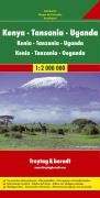
East Africa Road Map (Kenya, Tanzania, Uganda) (German Edition)
Sprache: Englisch
Verlag: Freytag-Berndt (edition ), 2006
ISBN 10: 3850842215 ISBN 13: 9783850842211
Map. Zustand: Fair. The item might be beaten up but readable. May contain markings or highlighting, as well as stains, bent corners, or any other major defect, but the text is not obscured in any way.
-
East Africa Road Map (Kenya, Tanzania, Uganda) (German Edition)
Sprache: Englisch
Verlag: Freytag-Berndt u Artaria, Germany, 2006
ISBN 10: 3850842215 ISBN 13: 9783850842211
Anbieter: Stony Hill Books, Madison, WI, USA
Verkäuferbewertung 4 von 5 Sternen

Map. Zustand: Very Good. Large folding map in glossy pictorial card covers, graphics different than in stock picture, multi-lingual text, appears never opened VG++ condition.
-
East Africa Road Map (Kenya, Tanzania, Uganda) (German Edition)
Anbieter: Blindpig Books, Salt lake city, UT, USA
Verkäuferbewertung 5 von 5 Sternen

Karte
map. Zustand: Used - Good. Some wear. Very readable copy.
-

The lands and peoples of Kenya, Uganda and Tanzania. With fifteen photographs and a map
Verlag: London, Adam & Charles Black, [, 1968
Anbieter: Hammer Mountain Book Halls, ABAA, Schenectady, NY, USA
Verkäuferbewertung 5 von 5 Sternen
Hardcover. Covers faintly dust-soiled; inside margin and pages adjacent to plates slightly foxed; otherwise very good condition in slightly worn, clipped dust jacket. No markings. ]. 96p. Illus.
-
map. Zustand: Very Good. We have 75,000 books to choose from -- Ship within 24 hours -- Satisfaction Guaranteed!
-
East Africa Road Map (Kenya, Tanzania, Uganda) (German Edition)
Anbieter: Bristlecone Books RMABA, Ridgway, CO, USA
Verbandsmitglied: RMABA
Verkäuferbewertung 4 von 5 Sternen
Karte
Soft cover. Zustand: Near Fine. No Jacket. Near fine map, 1:2000000 german edition.
-
Zustand: very good. Gut/Very good: Buch bzw. Schutzumschlag mit wenigen Gebrauchsspuren an Einband, Schutzumschlag oder Seiten. / Describes a book or dust jacket that does show some signs of wear on either the binding, dust jacket or pages.
-
Ayear Book & Guide To East Africa 1951 Including Egypt, Sudan, Eritrea, Somaliland, Kenya, Uganda, Tanganyika, Zanzibar, Nyasaland, Portugese East Africa, The Congo, Mauritius , Madagascar, Reunion Etc Etc. With A Folding Map. Towen Plans And Route Maps
Sprache: Englisch
Verlag: Union Castle Mail Steamship Company. Robert Hale Ltd London, London, 1951
Anbieter: Westside Stories, Hamilton, ON, Kanada
Verkäuferbewertung 5 von 5 Sternen
Hardcover. Zustand: Very Good. No Jacket. First Thus. A Very Solid Book, Slight Aging To Pages Over 100 Pages Of Adverts, 16 Pages Of Maps And A Folded Map In A Front Pocket. Ribbon Marker Still Attached And Tied To An Integral Stand Bank Of South Africa Book Mark. Previous Owners Name On The First Page, Though It Appear The Ffep Has Been Removed. Very Slight Fraying To Edge Of Front Pages . Red Boards Cloth Covered And Very Slightly . Shaken But Holding Very Well. Gilt Title On Front Board And Slightly Faded Gilt Title On Spine. Only Minor Bumping Particularly To Spine Ends.
-
Tanzania, Kenya, Uganda Road Map
Verlag: Freytag & Berndt
Anbieter: Wonder Book, Frederick, MD, USA
Verkäuferbewertung 5 von 5 Sternen
Zustand: Fair. Acceptable condition. No date stated, ca. 1990s. [9783850842211] (East Africa, Road Maps) A readable, intact copy that may have noticeable tears and wear to the spine. All pages of text are present, but they may include extensive notes and highlighting or be heavily stained. Includes reading copy only books.
-

Uganda Travel Reference Map 2024 edi
Anbieter: Majestic Books, Hounslow, Vereinigtes Königreich
Verkäuferbewertung 4 von 5 Sternen
EUR 20,45
EUR 7,49 Versand
Versand von Vereinigtes Königreich nach USAAnzahl: 1 verfügbar
In den WarenkorbZustand: New.
-
Zustand: New.
-
National Geographic Magazine - August, 2020. Stopping Pandemics. With Map Supplement, 'The World', Laid-In. Stopping Pandemics; Metropolis on Lockdown; Life Becomes Quarantine; Dodo's New Look; India's Water Crisis; 100 Years of Suffrage; Uganda Chimpanzees
Sprache: Englisch
Verlag: National Geographic Society, Washington, DC, 2020
Anbieter: Singularity Rare & Fine, Baldwinsville, NY, USA
Verkäuferbewertung 5 von 5 Sternen
Erstausgabe
Soft cover. Zustand: New. 1st Edition. New, and pristine, with Map enclosed; see scans and description. Washington, DC: National Geographic Society, 2019. The August, 2020 issue, 'Stopping Pandemics'. With Map Supplement, 'The World', Laid-In. Quarto, photo-illustrated perfect-bound wraps,138 pp. New, bright, pristine and squeaky clean, removed from shipping bag only for scanning and description, and now in protective storage, on premises, of course. See scans. Feature articles include: Stopping Pandemics; Metropolis on Lockdown; Life Becomes Quarantine; Dodo's New Look; India's Water Crisis; 100 Years of Suffrage; Uganda Chimpanzees . More, as well, as always. Brand New, collectible condition. Ships in a new, sturdy, protective box - not a bag. LNG1.
-

Mount Elgon - Massaba (Kenya Uganda) map and guide
Anbieter: THE SAINT BOOKSTORE, Southport, Vereinigtes Königreich
Verkäuferbewertung 5 von 5 Sternen
EUR 19,11
EUR 13,59 Versand
Versand von Vereinigtes Königreich nach USAAnzahl: 17 verfügbar
In den WarenkorbMap. Zustand: New. New copy - Usually dispatched within 4 working days.
-
The Year Book and Guide to East Africa, 1964 (Kenya, Uganda, Tanganyika, Zanzibar, Portugeuse East Africa, Mauritius, Seychelles, etc. with Atlas, Folding Map and Town Plans
Sprache: Englisch
Verlag: Robert Hale, London, UK, 1964
Anbieter: All Lost Books, Wollaston, Vereinigtes Königreich
Verkäuferbewertung 5 von 5 Sternen
EUR 21,37
EUR 23,28 Versand
Versand von Vereinigtes Königreich nach USAAnzahl: 1 verfügbar
In den WarenkorbHardcover. Zustand: Very Good. Zustand des Schutzumschlags: Good. Includes 13*colour maps (one folding) and many b/w maps and several colour illustrations. xxxiv+352+16pp. DJ rubbed and nicked at edges. 1.5cm closed tear to lower rear DJ edge, Red cloth boards with gilt lettering.
-

National Geographic Magazine - August, 2020. Stopping Pandemics. With Map Supplement, 'The World', Laid-In. Stopping Pandemics; Metropolis on Lockdown; Life Becomes Quarantine; Dodo's New Look; India's Water Crisis; 100 Years of Suffrage; Uganda Chimpanzees
Verlag: National Geographic Society, 2020
Anbieter: Shore Books, London, Vereinigtes Königreich
Verkäuferbewertung 5 von 5 Sternen
Magazin / Zeitschrift
EUR 17,81
EUR 12,68 Versand
Versand von Vereinigtes Königreich nach USAAnzahl: 1 verfügbar
In den WarenkorbSoft cover. Zustand: Very Good. 138 pages. Illustrated.
-

Mount Elgon - Massaba (Kenya Uganda) map and guide
Anbieter: Rarewaves.com USA, London, LONDO, Vereinigtes Königreich
Verkäuferbewertung 5 von 5 Sternen
EUR 39,57
Versand gratis
Versand von Vereinigtes Königreich nach USAAnzahl: 1 verfügbar
In den WarenkorbMap. Zustand: New. 1989th.
-
Map of Central Africa - Eastern Section from the 1920 Times Survey Atlas (Plate 75) including Lake Victoria, Uganda, Kenya Colony, Tanganyika Territory, Belgian Congo (part), Northern Rhodesia (part), Nyasaland Protectorate, etc.
Verlag: The Times, London, 1920
Anbieter: Bailgate Books Ltd, Doncaster, Vereinigtes Königreich
Verkäuferbewertung 5 von 5 Sternen
Karte Erstausgabe
EUR 22,80
EUR 16,71 Versand
Versand von Vereinigtes Königreich nach USAAnzahl: 1 verfügbar
In den WarenkorbSoftcover. Zustand: Very Good. Zustand des Schutzumschlags: No Dust Jacket. First Edition. Disbound single sheet with horizontal centre fold from the 1920 "The Times Survey Atlas of the World". Map is in colour and suitable for framing. Colour on both land and sea according to contour with borders marked in red. Map at scale 1:5,000,000. Map covers; Lake Victoria, Lake Nyasa, Lake Tanganyika, Lake Albert, Uganda, Kenya Colony, Tanganyika Territory, Belgian Congo (part), Northern Rhodesia (part), Nyasaland Protectorate, Portuguese East Africa (part), Zanzibar, Azanian Sea, etc. Slightly darkened edges with occasional light foxing in margins but sheet is otherwise clean and crisp. Item Type: Map. Single sheet map/chart which is suitable for framing and will be shipped rolled and in a cardboard tube. Quantity Available: 1. Shipped Weight: under 1 kg. Pictures of this item not already displayed here available upon request. Inventory No: 45020034032. All our books are sent by tracked mail.
-
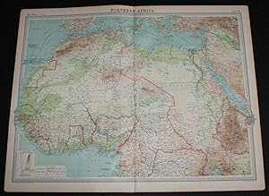
Map of Northern Africa from the 1920 Times Survey Atlas (Plate 69) including Morocco, Algeria, Libya, Egypt, Senegal, French West Africa, Nigeria, Cameroon, Uganda, Red Sea, etc.
Verlag: The Times, London, 1920
Anbieter: Bailgate Books Ltd, Doncaster, Vereinigtes Königreich
Verkäuferbewertung 5 von 5 Sternen
Karte Erstausgabe
EUR 22,80
EUR 16,71 Versand
Versand von Vereinigtes Königreich nach USAAnzahl: 1 verfügbar
In den WarenkorbSoftcover. Zustand: Very Good. Zustand des Schutzumschlags: No Dust Jacket. First Edition. Disbound single sheet with vertical centre fold from the 1920 "The Times Survey Atlas of the World". Map is in colour and suitable for framing. Colour on both land and sea according to contour with borders marked in red. Map at scale 1:12,000,000. Map covers; Morocco, Algeria, Libya, Egypt, Senegal, French West Africa, Nigeria, Cameroon, Uganda, Ivory Coast, Gold Coast, French Guinea, Borku, Chad, Abyssinia (part), Belgian Congo (part), Madeira Islands, Canary Islands, Spain (part), Red Sea, Gulf of Guinea, Mediterranean Sea (part), Arabia (part), etc. Slightly darkened edges with occasional light foxing in margins but sheet is otherwise clean and crisp. Item Type: Map. Single sheet map/chart which is suitable for framing and will be shipped rolled and in a cardboard tube. Quantity Available: 1. Shipped Weight: under 1 kg. Pictures of this item not already displayed here available upon request. Inventory No: 45020034028. All our books are sent by tracked mail.
-

paperback. Zustand: New. Language:Chinese.Paperback. Pub Date: 2023-04 Publisher: Planet Map Press World Geographical Maps - Uganda is published by Planet Map Press.
-
The Year Book and Guide to East Africa. (Including Egypt, Sudan, Eritrea, Somaliland, Kenya, Uganda, Tanganyika, Zanzibar, Nyasaland, Portuguese, East Africa, the Congo, Mauritius, Madagascar, Reunion etc., etc.) with Atlas, Folding Map, Town Plans and Route Maps.
Sprache: Englisch
Verlag: London, A. Gordon-Brown, 1952
Anbieter: Antiquariat Weinek, Salzburg, Österreich
Verkäuferbewertung 4 von 5 Sternen
XXXII + 435 + 16 + 107 S. OLwd. In Englisch. - Mit allen Karten u. Mappe. - Ebd. stärker berieben u. fleckig, sonst leichte Gbrsp.
-

Uganda: NEL.315 (Nelles Map)
Anbieter: Sell Books, Elland, YORKS, Vereinigtes Königreich
Verkäuferbewertung 5 von 5 Sternen
EUR 39,41
EUR 14,00 Versand
Versand von Vereinigtes Königreich nach USAAnzahl: 1 verfügbar
In den Warenkorbmap. Zustand: Acceptable. Please see the condition note after this for details, if this is missing please consider Acceptable to mean poor quality that could include major staining, water damage, writing, missing dustjacket, etc etc. Our books are dispatched from a Yorkshire former cotton mill. We list via barcode/ISBN so please note that the images are stock images and may not be the exact copy you receive, furthermore the details about edition and year might not be accurate as many publishers reuse the same ISBN for multiple editions and as we simply scan a barcode or enter an ISBN we do not check the validity of the edition data when listing. If you're looking for an exact edition please don't order (at least not without checking with us first, although we don't always have time to check). We aim to dispatch prompty, the service used will depend on order value and book size. We can ship to most countries, see our shipping policies. Payment is via Abe only.
-
Some African Highways, A Journey of Two American Women to Uganda and the Transvaal. With An Introduction By Lieutenant-General Baden-Powell. With Illustrations from Photographs and a Map.
Verlag: London: Duckworth & Co., 1908
Anbieter: Westwood Books Sedbergh, Sedbergh, Vereinigtes Königreich
Verbandsmitglied: PBFA
Verkäuferbewertung 5 von 5 Sternen
EUR 23,74
EUR 23,05 Versand
Versand von Vereinigtes Königreich nach USAAnzahl: 1 verfügbar
In den WarenkorbZustand: Good. 8vo: xvi, 345pp. 28 tipped in plates and one folding map. Rubbed orange cloth, faded on spine, without dust wrapper. Black lettering and decor on spine and covers. Former ownership inscription on half title page. Tanned endpapers. Minor tanning from plates on opposing pages.
-
Kenya, Uganda(Double-sides)--World Map by Countries(Chinese Edition)
Verlag: China Cartographic Publishing House, 2000
ISBN 10: 7503129212 ISBN 13: 9787503129216
Soft cover. Zustand: New. Language:Chinese.Author:BEN SHE,YI MING.Binding:Soft Cover.Publisher:China Cartographic Publishing House.
-
Some African highways. A journey of two American women to Uganda and the Transvaal. With an Imtroduction by Lieutenant-General Baden-Powell. With illustartions from photographs and a map.
Verlag: London, Duckworth & Co.,, 1908
Anbieter: Cobnar Books, Deal, Vereinigtes Königreich
Verbandsmitglied: PBFA
Verkäuferbewertung 4 von 5 Sternen
Erstausgabe
EUR 24,57
EUR 24,41 Versand
Versand von Vereinigtes Königreich nach USAAnzahl: 1 verfügbar
In den Warenkorbxvi, 11-345 p. Folded map, illustrations. First edition. 20 cms. Publisher's printed green cloth. Endpapers toned and the rear free enpaper missing but a good solid reading copy.
-
SOUTH UGANDA IN NORTHEAST AFRICA, 1890s WOOD ENGRAVING, ANTIQUE PRINT,HISTORICAL RELIEF MAP CHART SHOWING TERRAIN, TOPOGRAPHY AND ENVIRONS
Verlag: Reclus
Anbieter: Artisans-lane Maps & Prints, Sidney, BC, Kanada
Verkäuferbewertung 4 von 5 Sternen
Kunst / Grafik / Poster
no binding. Zustand: very good. The Republic of Uganda, or Uganda, is a country in East Africa, bordered in the east by Kenya, in the north by Sudan, by the Democratic Republic of Congo in the west, Rwanda in the southwest and Tanzania in the south. The southern part of the country includes a substantial portion of Lake Victoria, within which it shares borders with Kenya and Tanzania. Uganda takes its name from the historical Buganda kingdom, which encompasses a portion of the south of the country, including the capital Kampala. Little is known about the history of the region now covered by Uganda until the arrival of the Arabs and Europeans in the mid 1800s. Humans are known to have lived in the area since at least the first millennium BC. When Arabs and Europeans arrived in the 19th century, they encountered a number of kingdoms in the area. They included Ankole, Buganda, Bunyoro, Busoga, and Toro. The largest of these kingdoms was Buganda, which exists as part of Uganda today. Islam and Christianity were introduced to these kingdoms. The area was placed under the charter of the British East Africa Company in 1888, and was ruled as a protectorate by the United Kingdom from 1894.MAP SHOWS STANLEY ROUTES. Overall Size including borders : 10 1/2 x 7 Ins . CONDITION: Clear and sharp with beautiful detail. As scanned. These beautiful prints would look great matted and framed. Or an art supply store can provide you with a selection of frames for old art treasures. NOTE THE FOLLOWING BEFORE YOU PURCHASE: This is a GENUINE ANTIQUE VINTAGE 1880s PRINT. It is NOT a modern reproduction, ie. a laser scan, photocopy etc. It is the original from the antique or vintage atlas or book publication. This print was published on the date mentioned, or circa of the date mentioned at the top of the page. The print I have for sale, like many antique vintage prints and maps that you see online, originate from an antique vintage book or atlas publication. The publication may not always be known. If you have any questions, emails are welcome.
-

Uganda for a holiday / by Sir Frederick Treves ; with seventy- two illustrations from photographs by the author and a map
Verlag: London : Smith, Elder, 1910
2nd impression. Very good copy in the original gilt-blocked cloth. Top edge gilt. Spine bands and panel edges somewhat dulled and rubbed as with age. Light foxing. Remains quite well-preserved overall. Physical description: xi, 233 p., [41] leaves of plates : ill., fold. map ; 23 cm. Subjects: Uganda Description and travel. Kenya Description and travel. Africa, East ; Handbooks, manuals, etc. 3 Kg.
-
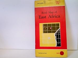
Road Map of East Africa - Section 2 - covering: Tanganyika (Southern Portion), Kenya and Uganda - Maßstab: 1 : 1.000.000
Sprache: Englisch
Verlag: London, Foldex
Anbieter: ABC Versand e.K., Aarbergen, Deutschland
Verkäuferbewertung 5 von 5 Sternen
Karte
Zustand: Gut. 1 Straßenkarte Straßenkarte von Ost-Afrika (Tanganijka, Kenia und Uganda) mit leichten altersbedingten Gebrauchsspuren, ohne Jahresangabe, ca. 1950er-Jahre, Kartendeckel leicht angestaubt, Ecken und Kanten bestoßen, Karte farbig, sehr gut erhalten, Sprache: EN; diese Karte schließt an an Abschnitt 1 der Shell Road Map von Ost-Afrika Ordner9 Sprache: Englisch Gewicht in Gramm: 202.
-
TRAVEL MAP OF UGANDA
Verlag: Tourguide Publications, UGANDA
Anbieter: Richard Sylvanus Williams (Est 1976), WINTERTON, Vereinigtes Königreich
Verkäuferbewertung 5 von 5 Sternen
EUR 6,21
EUR 34,57 Versand
Versand von Vereinigtes Königreich nach USAAnzahl: 1 verfügbar
In den WarenkorbPaperback. Zustand: nrVG. 560 x 80 mm.map folded to 140 x 200mm. In nice condition BUT one or two tears to folds.
-

Uganda for a holiday / by Sir Frederick Treves ; with seventy- two illustrations from photographs by the author and a map
Verlag: London : Smith, Elder, 1910
2nd impression. Very good copy in the original gilt-blocked cloth. Top edge gilt. Spine bands and panel edges somewhat dulled and rubbed as with age. Light foxing. Remains quite well-preserved overall. Physical description: xi, 233 p., [41] leaves of plates : ill., fold. map ; 23 cm. Subjects: Uganda Description and travel. Kenya Description and travel. Africa, East ; Handbooks, manuals, etc. 1 Kg.
-

Uganda map 1.25*0.9 meters. world map with country divisions. folding sleeve.(Chinese Edition)
Sprache: Englisch
ISBN 10: 7547120946 ISBN 13: 9787547120941
paperback. Zustand: New. Language:Chinese.Paperback. Pub Date: 2024-01 Publisher: Planet Map Publishing House.