Gesamtpreis (1 Artikel Artikel):
Versandziel:

united states america von rand mcnally (31 Ergebnisse)
Direkt zu den wichtigsten Suchergebnissen
Produktart
- Alle Produktarten
- Bücher (31)
- Magazine & Zeitschriften
- Comics
- Noten
- Kunst, Grafik & Poster
- Fotografien
- Karten
-
Manuskripte &
Papierantiquitäten
Zustand
Einband
Weitere Eigenschaften
- Erstausgabe (1)
- Signiert
- Schutzumschlag (2)
- Angebotsfoto (11)
- Kein Print-on-Demand
Land des Verkäufers
Verkäuferbewertung
-

America : A Celebration of the United States
Verlag: Rand McNally, 1999
ISBN 10: 0528841742ISBN 13: 9780528841743
Buch
Zustand: Good. Used book that is in clean, average condition without any missing pages.
Mehr Angebote von anderen Verkäufern bei AbeBooks
Neu ab EUR 58,08
Gebraucht ab EUR 5,06
Mehr entdecken Hardcover
-

United States of America (Road Map)
Verlag: Hallwag,Bern
ISBN 10: 3828300472ISBN 13: 9783828300477
Buch
Paperback. Zustand: Used; Good. **SHIPPED FROM UK** We believe you will be completely satisfied with our quick and reliable service. All orders are dispatched as swiftly as possible! Buy with confidence! Greener Books.
-

Soft cover. Zustand: Near Fine. Large folio, about 24" by 12", near fine in blue and yellow pictorial wraps. 40th anniversary edition. Gives several pages on great north American attractions, scenic drives, and vistas across US and Canada. Cover letter from State Farm enclosed. 136 pp. of maps. mileage charts, driving times, index of cities, highways, smaller routes, roadways color delineated. Very thorough Atlas. A great asset if you're planning a road trip. Book.
-
Discover North America (United States, Canda, Mexico) Road Atlas
Verlag: Rand McNally
Anbieter: Wonder Book, Frederick, MD, USA
Bewertung:

Zustand: Good. Good condition. Slightly dampstained. (North America, United States, Map, Atlas).
-

Rand McNally's America: a Traveler's Portrait of the United States
Verlag: Rand McNally, Chicago, 1989, 1989
ISBN 10: 0528833642ISBN 13: 9780528833649
Buch
Zustand: Very Good. Zustand des Schutzumschlags: Unknown. David Muench, Photos (illustrator). Folio, hardcover near fine in white pictorial dj. 224 pages; clean with color illustrations and maps throughout. An exciting atlas with hundreds of photos, maps and illustrations celebrating the USA. covering a spectacular 5000 miles from New England's fog bound coast through the Hearland's prairies, across the Rockies and Southwest's deserts to the Pacific Coast and tropical Hawaii. Book.
-

These States United: Atlas of American History
Verlag: Rand McNally, 1974
ISBN 10: 052817701XISBN 13: 9780528177019
Buch
Zustand: good. Book may contain some writing, highlighting, and or cover damage. Shipped fast and reliably!.
Mehr Angebote von anderen Verkäufern bei AbeBooks
Gebraucht ab EUR 33,92
-

United States of America Map: Country Map
Verlag: Hallwag,Bern, 1988
ISBN 10: 3444004729ISBN 13: 9783444004728
Buch
Map. Zustand: Good. NOT an ex-library book. Clean copy in good condition. Quick dispatch from UK seller.
-
This detailed map was originally published in Rand, McNally & Co.s Universal Atlas of The World. From its beginnings as a small Chicago printing shop in 1856, Rand McNally & Company launched a 146-year continuing journey that has led the company to its place as the world's premier provider of geographic and travel information. This colorful map was published at the turn of the century in 1902. This page shows us the relative heights of various buildings of the world by superimposing images over each other. This map measures 14 inches by 11 inches.
-
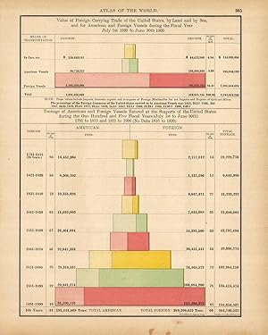
This large scale map came from Rand McNallys Commercial Atlas of America. The Rand McNally Atlas was unusual for its time because it was designed to be used by merchants and shippers. Therefore this map is exceptionally detailed in that it shows every railroad, post office, and small town in existence at that time. Many towns shown in this map have since ceased to exist, or have been swallowed up by larger towns. This map is therefore the definitive reference for how North America looked at the turn of the century. Every railroad is featured in a table in margin of map. This map measures 13 inches by 19 inches.
-
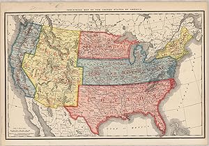
This large format map was published in Rand McNally & Co.s Indexed Atlas of the World, dated 1911. This map details Industry of the United States of America. This map measures 12.5 inches by 19.5 inches.
-
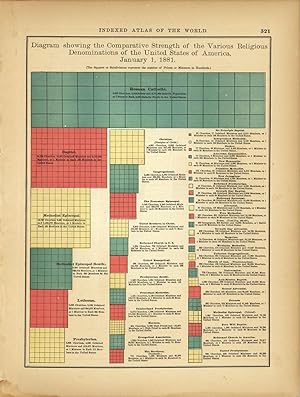
This fourth edition of Rand McNally and Co.s "Indexed Atlas of the World" was produced in 1882. Each very detailed map has light pastel coloring and identifies regions, major sea routes, railroad lines, important cities and land-forms. The atlas also included several special diagrams noting various commerce, religions, agriculture and more. This diagram breaks down all the religious denominations in the United States as of January 1, 1881. The squares represent the number of Priests or Ministers in hundreds. This map measures 12.5 inches by 9 inches.
-
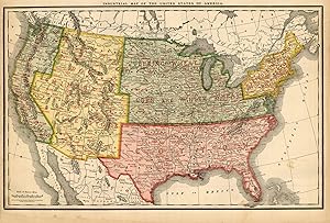
This large format map was published in Rand McNally & Co.s Indexed Atlas of the World, dated 1908. THis maps details Industrial Map of the United States of America' This map measures 12.5 inches by 19 inches.
-
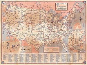
United States Defense Map Detailed overview of American defenses in the midst of 1941.
Erscheinungsdatum: 1941
Anbieter: Curtis Wright Maps, Berwyn, IL, USA
Bewertung:

Zustand: Very Good. This interesting double sided map provides an in-depth look at the defensive capabilities of the Americas as World War II began to ramp up across the globe. The United States Defense Map highlights the various Army, Navy, or Air Force military installations across the country, with main transportation routes highlighted and labeled. An inset map in the lower left broadly illustrates the domestic production of war materials like petroleum, coal, and iron. The verso shows a broader perspective, noting the fortifications, bases, and combat zones across the Western Hemisphere. An inset map provides details on the Pacific Theater, and the bottom of the sheet provides a chronology of events beginning with German aggression in 1935 to the loss of French Indo-China in July of 1941. Published in Chicago by Rand McNally on behalf of Richfield Oil Company. Sheet Width (in) 26.6 Sheet Height (in) 19.75 Condition Description Several areas of moderate discoloration visible on both sides. Creasing along originally issued fold lines, and faint edge wear present.
-
This map was produced by Rand McNally and Company for its "Business Atlas and Shippers Guide" in 1888. These highly detailed maps were acknowledged as the premier business shipping maps with much attention paid to even the smallest of villages. This map measures 13 inches by 19.5 inches.
-
This Industrial Map of the United States of America was produced by Rand McNally and Co. as part of its Commercial Atlas of America. These maps are some of our favorite maps because of the large size of each map. The detail shown on each map is exceptional because of the map size. These maps were intended to be used by business for shipping and other uses. Roads, railroads, rivers, and buildings are clearly shown. There is more detail on these maps than any others during this time period.The map measures 25.5 by 19 inches.
-
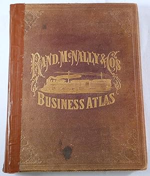
Rand, McNally & Co.'s Business Atlas. Containing Large Scale Maps of Each State and Territory of the United States.; And a Ready Reference Index Showing.Entire Railroad System of North America
Verlag: Rand McNally & Co, Chicago, 1878
Erstausgabe
Hardcover. Zustand: Fair. First Edition. Chicago: Rand McNally & Co, 1878. First edition, 1878. Externally worn but internally very good. Includes maps of all US states and territories at the time, plus the Canadian maritime provinces. Maps are printed in black and white and most with an additional single color, with four of them being large linen-backed folding maps: New York; Illinois; Texas and Indian Territory; California and Nevada. Double page and folding maps are mounted on stubs. Also includes information on towns and cities as well as additional information about railroads, arranged by state. Rail lines are also shown on the maps. Brown cloth over beveled boards lettered and decorated in gilt, all edges tinted red, 14.25" tall, about 11" wide. Spine covering is absent and has been replaced with brown tape, covers additionally worn with some spotting, front hinge cracked, text block sound, pages slightly age-yellowed but clean, maps very good with some foxing to the blank sides of the linen-backed maps which also affect the text pages opposite, modern name and address stamp at top of front pastedown and at bottom of final index pages, original bookseller stamp at lower corner of title page, original Rand McNally ticket a upper corner of rear pastedown. First Edition. Hard Cover. Fair. Folio - 12" - 15" Tall.