Gesamtpreis (1 Artikel Artikel):
Versandziel:

vegetation map south america (10 Ergebnisse)
Direkt zu den wichtigsten Suchergebnissen
Produktart
- Alle Produktarten
- Bücher (8)
- Magazine & Zeitschriften
- Comics
- Noten
- Kunst, Grafik & Poster
- Fotografien
- Karten (2)
-
Manuskripte &
Papierantiquitäten
Zustand
- Alle
- Neu
- Antiquarisch/Gebraucht
Einband
- alle Einbände
- Hardcover
- Softcover (7)
Weitere Eigenschaften
- Erstausgabe (2)
- Signiert
- Schutzumschlag
- Angebotsfoto (3)
- Kein Print-on-Demand
Land des Verkäufers
Verkäuferbewertung
-

Vegetation Maps of Africa, South America and the World (General) International Bibliography of Vegetation Maps, Volume 4
Verlag: University of Kansas Library, 1970
Zustand: Good. *Price HAS BEEN REDUCED by 10% until Monday, April 29 (sale item)* 561 pp., paperback, ex library, else text clean & binding tight. - If you are reading this, this item is actually (physically) in our stock and ready for shipment once ordered. We are not bookjackers. Buyer is responsible for any additional duties, taxes, or fees required by recipient's country.
-
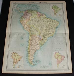
South America (Political & Industrial); Inset map of South America (Mean annual) Rainfall; South America (Vegetation)
Erscheinungsdatum: 1920
Karte
Zustand: Good. SOUTH AMERICA. Political & Industrial; Rainfall Vegetation. HARMSWORTH 1920 map. Vintage colour map; Scale 1:19,000,000; Harmsworth (1920). 44.5 x 35.0cm, 17.5 x 13.75 inches. Condition: Good. This map was originally printed as two separate pages which have been professionally joined to form a single sheet. There are images and/or text printed on the reverse side of the picture. In some cases this may be visible on the picture itself or around the margin of the picture.
-

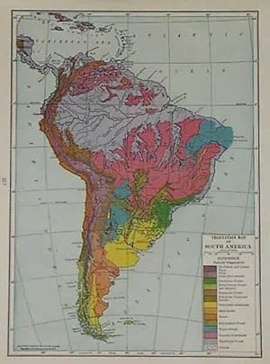
A Vegetation Map of South America: Mapa de la Vegetacion de America del sur: Mapa da Vegetacao da America do sul
Verlag: European Commission, 2002
ISBN 10: 9289444495ISBN 13: 9789289444491
Buch
Zustand: Good. This is an ex-library book and may have the usual library/used-book markings inside.This book has soft covers. In good all round condition. Written in English, Spanish and Brazilian Portuguese. Please note the Image in this listing is a stock photo and may not match the covers of the actual item,300grams, ISBN:9789289444491.
-

Vegetation Map of South America: Explanatory Notes
Verlag: United Nations Educational, 1981
ISBN 10: 923001933XISBN 13: 9789230019334
Buch
Zustand: Good. This is an ex-library book and may have the usual library/used-book markings inside.This book has soft covers. In good all round condition. Written in English, French and Spanish Please note the Image in this listing is a stock photo and may not match the covers of the actual item,600grams, ISBN:923001933X.
-
International Bibliography of Vegetation Maps. Volume 4: Africa, South America and World Maps
Verlag: University of Kansas Libraries,, 1970
Buch
25 x 16. 561 Seiten. OBrosch. Ordnungsgemäß aus einer Universitäts-Bibliothek ausgesondert (Stempel, Rückenschild). Broschureinband mit Randläsuren, sonst guter Zustand. Gewicht über 1 kg. Sprache: Englisch Gewicht in Gramm: 1250.
-
Vegetation Map of South America text in English , Spanish and French
Verlag: UNESCO, Paris, 1981
ISBN 10: 923001933XISBN 13: 9789230019334
Buch Erstausgabe
PAPERBACK. First edition. 189pp maps quarto paper. slight cover wear otherwise very good.
-
This map was made for C.S Hammonds World Atlas in 1936. Machine coloring, primarily in pastels, along with fine detailing and a simple border are among the features of Hammond's maps. Most maps included in this atlas collection illustrate capitals, boundaries, major cities, towns, and transportation details, such as canals, railroads and steam ship routes. Maps from this pre World War II time period are difficult to find. This map measures 10 inches by 7 inches.
-
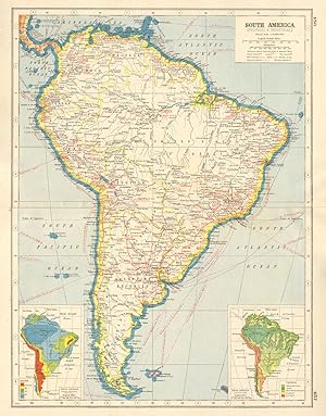
Map of South America from the 1920 Times Survey Atlas (Plate 104 South America - Political) Including Inset Maps for Population Density, Race and Vegetation
Verlag: The Times, London, 1920
Karte Erstausgabe
Softcover. Zustand: Very Good. Zustand des Schutzumschlags: No Dust Jacket. First Edition. Disbound single sheet with horizontal centre fold from the 1920 "The Times Survey Atlas of the World". Map is in colour and suitable for framing. Map scale 1:17,000,000. Map covers the whole of South America including; Colombia, Venezuela, Ecuador, British, Dutch and French Guiana, Peru, Brazil, Bolivia, Paraguay, Chile, Argentina, Uruguay, The Falkland Islands, South Georgia, Juan Fernandez Islands, Central America including Panama, Costa Rica and Nicaragua and part of the West Indies including Jamaica and Haiti, etc. Countries are differentiated using pastel colours. Sheet contains three inset diagram maps with contemporary data for Density of Population in persons per square mile, Races and Prevailing Vegetation. Slightly darkened edges with occasional light foxing in margins but sheet is otherwise clean and crisp. Item Type: Map. Single sheet map/chart which is suitable for framing and will be shipped rolled and in a cardboard tube. Quantity Available: 1. Shipped Weight: under 1 kg. Pictures of this item not already displayed here available upon request. Inventory No: 45020034010. For International tracked shipping please select the Priority shipping service.
-
-
Carte de la vegetation d'Amerique du Sud Notice explicative / Vegetation map of South America Explanatory notes / Mapa de la vegetacion de America del Sur. (Recherches sur les ressources naturelles / Natural resources research / Investigaciones sobre los recursos naturales XVII)
Verlag: UNESCO , c.1981, 1981
ISBN 10: 923001933XISBN 13: 9789230019334
Buch
paperback, Zustand: Very Good, Unesco, c.1981, 8-1/4"x11-3/4", wraps, 189pp., ex-lib- ink stamps, VG- $.