
Gesamtpreis (1 Artikel Artikel):
Versandziel:

arrowsmith and lewis (9 Ergebnisse)
Direkt zu den wichtigsten Suchergebnissen
Produktart
- Alle Produktarten
- Bücher (9)
- Magazine & Zeitschriften
- Comics
- Noten
- Kunst, Grafik & Poster
- Fotografien
- Karten
-
Manuskripte &
Papierantiquitäten
Zustand
- Alle
- Neu
- Antiquarisch/Gebraucht
Einband
- alle Einbände
- Hardcover (3)
- Softcover
Weitere Eigenschaften
- Erstausgabe (1)
- Signiert (2)
- Schutzumschlag
- Angebotsfoto (5)
- Kein Print-on-Demand
Land des Verkäufers
Verkäuferbewertung
-

BATTEAUX That Old Time Boating on the James
Verlag: Arrowsmith and Lewis, 1988
ISBN 10: 0945391498ISBN 13: 9780945391494
Buch Erstausgabe Signiert
Hardcover. Zustand: Very Good+. First American Edition. Signed by author on title page, no inscription. Owner's name on top if inside front cover. ; Square Small 4to 9" - 11" tall; 70 pages; Signed by Author.
-

Batteaux - That old time boating on the James (edited and photographed by David Brown)
Verlag: Virginia, Arrowsmith and Lewis, 1988
ISBN 10: 0945391498ISBN 13: 9780945391494
Anbieter: ACADEMIA Antiquariat an der Universität, Freiburg, Deutschland
Verbandsmitglied: BOEV
Bewertung:

Buch
21,5 x 21,5 cm. Zustand: Gut. 1. 70 Seiten broschierter deckelillustrierter Einband im Oktavformat; sehr gut erhaltenes, schönes Exemplar mit schönen Schwarzweiß-Fotografien Sprache: Englisch Gewicht in Gramm: 1.
-

unknown_binding. Zustand: Fine. Signed. SIGNED BY THE AUTHOR Hardcover. No dust jacket. Minor cover wear. Clean unmarked text. Tight binding. ** WE SHIP DAILY (Mon-Fri) ** Free Tracking Information.
-

West Indie's - The Caribbean during the waning years of the slave trade.
Verlag: Aaron Arrowsmith and Samuel Lewis
Anbieter: Curtis Wright Maps, Berwyn, IL, USA
Bewertung:

"After Columbus's momentous voyage of 1492 in which he claimed to have found India, Europeans began to call his discoveries the "West Indies" to distinguish them from the "East Indies" of southeast Asia. Though the error was made quickly apparent, the toponym would persist in our nomenclature to this day; though the modern conception generally only includes the island nations, and not Central America, Mexico, or the Gulf Coast. This map shows the region in the early 19th century, though it's based on cartography from a decade or so prior. Details are sparse outside of place names, maritime hazards, and geographic features. Designed by Aaron Arrowsmith and Samuel Lewis and engraved by Thomas Marshall. Published in Philadelphia by Joseph Conrad in 1804, as part of A new and elegant general atlas." Sheet Height (in) 8.8 Condition A- Moderate wear, faint soiling, and a ragged lower edge are confined to the margins of the sheet. A bit of discoloration in the image from the plate strike, but overall in near fine condition.
-
New Hampshire.
Verlag: From Arrowsmith and Lewis' A New and Elegant General Atlas. Boston or Philadelphia. 1804 or later., 1804
Anbieter: Bickerstaff's Books, Maps &c., Scarborough, ME, USA
Verbandsmitglied: ABAA ESA ILAB
Bewertung:
Drawn by S. Lewis and engraved by Tanner, this map of New Hampshire identifies five counties: Cheshire, Grafton, Hillsborough, Rockingham and Strafford. The northern border follows hills noted as "Height of Land." Age toned. A few spots of foxing, primarily in the margins. 9 3/4 x 7 7/8.".
-
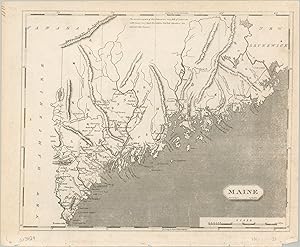
Maine - The District of Maine about fifteen years prior to statehood.
Verlag: Aaron Arrowsmith and Samuel Lewis
Anbieter: Curtis Wright Maps, Berwyn, IL, USA
Bewertung:
"This early 19th-century map shows the lower portions of what would eventually become the state of Maine. At the time of publication, the region was officially designated the District of Maine and was part of the Commonwealth of Massachusetts. Borders with adjacent British Canada were ambiguous at best, as referenced by the annotation near the top of the page, "The northern parts of this District are very full of Lakes, &c. with many very high Mountains, but their situations are not correctly known." Such mountains are shown with topography in hachure, such as the labeled "Height of Land" nearby. Elsewhere, scattered towns and settlements are connected by a rudimentary road network. Distances are shown between points, indicating some level of familiarity with the local geography. Designed by Aaron Arrowsmith and Samuel Lewis and engraved by William Hooker. Published in Philadelphia by Joseph Conrad in 1804, as part of A new and elegant general atlas." Sheet Height (in) 8.75 Condition A- Light wear visible around the outer edges, including faint discoloration and some tiny tears along the botto of the sheet. Some lightening to the image on the right side from the plate strike, but overall in very good condition.
-

South Carolina - South Carolina in the early 19th century.
Verlag: Aaron Arrowsmith and Samuel Lewis
Anbieter: Curtis Wright Maps, Berwyn, IL, USA
Bewertung:
The invention of the cotton gin propelled South Carolina's slave economy to new heights in the late 18th and early 19th centuries. The resulting commercial success is reflected on this map by the extensive settlement of the state, with numerous towns connected by a robust system of roads, trails, and navigable rivers. Distances between various points indicate that the geography of the region was well known at the time of publication. Outlined counties and districts comprised the majority of the land, with only a handful of Native American villages scattered throughout the interior, distinguished with small triangles. Topography is shown pictorially and geographic features like mountains, rivers, and islands are individually labeled. Designed by Aaron Arrowsmith and Samuel Lewis and engraved by D. Fairman. Published in Philadelphia by Joseph Conrad in 1804, as part of A new and elegant general atlas. Sheet Height (in) 8.75 Condition A- Faint spotting visible in the upper right corner of the sheet and a bit of moderate wear visible around the edges, consistent with age. A small hole in the center right of the page just touches the neatline. Very good to near fine overall.
-
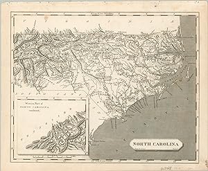
North Carolina - Antebellum North Carolina.
Verlag: Aaron Arrowsmith and Samuel Lewis
Anbieter: Curtis Wright Maps, Berwyn, IL, USA
Bewertung:
Geographic features dominate this early 19th-century map of North Carolina, which shows mountains (topography depicted in hachure), swamps, and rivers covering large portions of the state. An assortment of scattered towns and villages is also presented, connected by a rudimentary network of roads and trails. Distances between points are noted, indicating some level of familiarity with the state's geography. It's also important to note that the primary image presents only the eastern portion of the state. A small inset in the lower-left alludes to the vague western borders with Tennessee and Georgia, which were still very much in question at the time of publication. Designed by Aaron Arrowsmith and Samuel Lewis and engraved by Benjamin Tanner. Published in Philadelphia by Joseph Conrad in 1804, as part of A new and elegant general atlas. Sheet Height (in) 8.6 Condition B+ Moderate wear and light spotting visible along the top of the sheet, with a small spot in the center right near Pamlico Sound. Very good overall.
-
Vermont.
Verlag: From an unknown edition of Arrowsmith & Lewis' A New and Elegant General Atlas. No place. 1804 or later., 1804
Anbieter: Bickerstaff's Books, Maps &c., Scarborough, ME, USA
Verbandsmitglied: ABAA ESA ILAB
Bewertung:
An early 19th century rendition of Vermont with towns, county boundaries and a few roads shown. Credits appearing under the title of the map are "Drawn by S. Lewis." and "Engd by D. Fairman." Cobb: Vermont Maps Prior to 1900: 160, 162 or 187. Staining in left margin and a couple of very small spots in image area; otherwise very good. 9 3/4 x 7 7/8.".
