Gesamtpreis (1 Artikel Artikel):
Versandziel:

dublin ordnance survey office (55 Ergebnisse)
Direkt zu den wichtigsten Suchergebnissen
Suchfilter
Produktart
- Alle Product Types
- Bücher (51)
- Magazine & Zeitschriften (Keine weiteren Ergebnisse entsprechen dieser Verfeinerung)
- Comics (Keine weiteren Ergebnisse entsprechen dieser Verfeinerung)
- Noten (Keine weiteren Ergebnisse entsprechen dieser Verfeinerung)
- Kunst, Grafik & Poster (Keine weiteren Ergebnisse entsprechen dieser Verfeinerung)
- Fotografien (Keine weiteren Ergebnisse entsprechen dieser Verfeinerung)
- Karten (4)
- Manuskripte & Papierantiquitäten (Keine weiteren Ergebnisse entsprechen dieser Verfeinerung)
Zustand
- Alle
- Neu (Keine weiteren Ergebnisse entsprechen dieser Verfeinerung)
- Antiquarisch (55)
Einband
Weitere Eigenschaften
- Erstausgabe (3)
- Signiert (Keine weiteren Ergebnisse entsprechen dieser Verfeinerung)
- Schutzumschlag (Keine weiteren Ergebnisse entsprechen dieser Verfeinerung)
- Angebotsfoto (46)
- Keine Print-on-Demand Angebote (55)
Gratisversand
Verkäuferbewertung
-

Ireland 4 South East [ Folded Map]
Verlag: Ordnance Survey Office, Dublin, 1979
Softcover. Zustand: Very Good-. Zustand des Schutzumschlags: No Dust Jacket. Eighth Edition. Folded map in stiff paper covers. Some creasing. Covers have slight edge creasing.
-
Galway Offaly [ Map 15]
Verlag: Ordnance Survey Office, Government of Ireland, Dublin, 1978
Softcover. Zustand: Very Good. Zustand des Schutzumschlags: No Dust Jacket. Covers have some very slight creasing. ; Large folded map attached to stiff paper covers.
-

Discovery Series. 88, Covering part of county : Cork = rcaigh
Verlag: Dublin: Ordnance Survey Office, 2015
Fifth Edition. Near fine pamphlet copy; edges slightly dulled. Particularly well-preserved overall; tight, bright and clean. Series: Discovery Series / Ordnance Survey of Ireland; 88. Physical description: 1 map: col.; 64 x 84 cm., on sheet 76 x 99 cm., originally folded to 20 x 12 cm. Subjects: Cork (Irlande ; comté). Celtic Sea (Irlande; mer). Irlande. Ireland; Maps. Scale 1:50,000. Genre: Maps. 1 Kg.
-

Clare. Galway./ Ordnance Survey of Ireland
Verlag: Dublin: Ordnance Survey Office, 2008
ISBN 10: 1905511353 ISBN 13: 9781905511358
Fourth Edition. Near fine pamphlet copy; edges slightly dulled. Particularly well-preserved overall; tight, bright and clean. Series: Discovery Series / Ordnance Survey of Ireland; 51. Physical description: 1 map: col.; 64 x 84 cm., on sheet 76 x 99 cm., originally folded to 20 x 12 cm. Subjects: Irlande. Ireland; Maps. Scale 1:50,000. Ireland; Maps, Topographic. Genre: Maps. 1 Kg.
-

Clare = An Clár / compiled, printed and published by the Director at the Ordnance Survey Office
Verlag: Dublin: Ordnance Survey Office, 2008
ISBN 10: 190551137X ISBN 13: 9781905511372
Third Edition. Near fine pamphlet copy; edges slightly dulled. Particularly well-preserved overall; tight, bright and clean. Series: Discovery Series / Ordnance Survey of Ireland; 57. Physical description: 1 map: col.; 64 x 84 cm., on sheet 76 x 99 cm., originally folded to 20 x 12 cm. Subjects: Irlande; mer). Irlande. Ireland; Maps. Scale 1:50,000. Ireland; Maps, Topographic. Genre: Maps. 1 Kg.
-

Fourth Edition. Near fine pamphlet copy; edges slightly dulled. Particularly well-preserved overall; tight, bright and clean. Series: Discovery Series / Ordnance Survey of Ireland; 81. Physical description: 1 map: col.; 64 x 84 cm., on sheet 76 x 99 cm., originally folded to 20 x 12 cm. Subjects: Irlande. Ireland; Maps. Scale 1:50,000. Ireland; Maps, Topographic. Genre: Maps. 1 Kg.
-

Kilkenny Tipperary Laois = Cill Channigh Tiobraid Árann Laois / compiled, printed and published by the Director at the Ordnance Survey Office
Verlag: Dublin: Ordnance Survey Office, 2011
Third Edition. Near fine pamphlet copy; edges slightly dulled. Particularly well-preserved overall; tight, bright and clean. Series: Discovery Series / Ordnance Survey of Ireland; 60. Physical description: 1 map: col.; 64 x 84 cm., on sheet 76 x 99 cm., originally folded to 20 x 12 cm. Subjects: Irlande. Ireland; Maps. Scale 1:50,000. Ireland; Maps, Topographic. Genre: Maps. 1 Kg.
-

Kilkenny Tipperary: Cill Chainnigh Tiobraid Arann / compiled, printed and published by the Director at the Ordnance Survey Office
Verlag: Dublin: Ordnance Survey Office, 2006
ISBN 10: 1905511094 ISBN 13: 9781905511099
Third Edition. Near fine pamphlet copy; edges slightly dulled. Particularly well-preserved overall; tight, bright and clean. Series: Discovery Series / Ordnance Survey of Ireland; 67. Physical description: 1 map: col.; 64 x 84 cm., on sheet 76 x 99 cm., originally folded to 20 x 12 cm. Subjects: Ireland; Maps. Scale 1:50,000. Genre: Maps. 1 Kg.
-

Discovery Series. 48, Offaly; Westmeath
Verlag: Dublin: Ordnance Survey Office, 2015
ISBN 10: 190712215X ISBN 13: 9781907122156
Third Edition. Near fine pamphlet copy; edges slightly dulled. Particularly well-preserved overall; tight, bright and clean. Series: Discovery Series / Ordnance Survey of Ireland; 48. Physical description: 1 map: col.; 64 x 84 cm., on sheet 76 x 99 cm., originally folded to 20 x 12 cm. Subjects: Ireland; Maps. Scale 1:50,000. Genre: Maps. 1 Kg.
-

Leitrim Longford Roscommon Sligo = Liatroim An Longfort Ros Comain Sligeach / compiled, printed and published by the Director at the Ordnance Survey Office
Verlag: Dublin: Ordnance Survey Office, 2011
ISBN 10: 1905511434 ISBN 13: 9781905511433
Third Edition. Near fine pamphlet copy; edges slightly dulled. Particularly well-preserved overall; tight, bright and clean. Series: Discovery Series / Ordnance Survey of Ireland; 33. Physical description: 1 map: col.; 64 x 84 cm., on sheet 76 x 99 cm., originally folded to 20 x 12 cm. Subjects: Irlande. Ireland; Maps. Scale 1:50,000. Ireland; Maps, Topographic. Genre: Maps. 1 Kg.
-

Discovery series. No. 54 covering part of county: Laois Tipperary Offaly = : Laois, Tiobraid Árann, Uíbh Fhailí / compiled and published by Ordnance Survey Ireland
Verlag: Dublin: Ordnance Survey Office, 2011
ISBN 10: 1907122575 ISBN 13: 9781907122576
Third Edition. Near fine pamphlet copy; edges slightly dulled. Particularly well-preserved overall; tight, bright and clean. Series: Discovery Series / Ordnance Survey of Ireland; 54. Physical description: 1 map: col.; 64 x 84 cm., on sheet 76 x 99 cm., originally folded to 20 x 12 cm. Subjects: Irlande. Ireland; Maps. Scale 1:50,000. Ireland; Maps, Topographic. Genre: Maps. 1 Kg.
-

Clare Offaly Galway Tipperary: An Clár Uíbh Fhailí Gaillimh Tiobraid Árann / compiled, printed and published by the Director at the Ordnance Survey Office
Verlag: Dublin: Ordnance Survey Office, 2011
ISBN 10: 1907122567 ISBN 13: 9781907122569
Third Edition. Very good pamphlet copy; wrappers slightly edge-dulled. Pages tanned as with age. Remains particularly well-preserved overall. Physical description: 1 map: col. ; 64 x 84 cm., on sheet 76 x 99 cm., originally folded to 20 x 12 cm. Subjects: Ireland; Maps. Scale 1:50,000. Genre: Map. 1 Kg.
-

Clare, Kerry and Limerick: An Clar, Ciarrai, and Luimneach / compiled, printed and published by the Director at the Ordnance Survey Office
Verlag: Dublin: Ordnance Survey Office, 2006
ISBN 10: 1905511078 ISBN 13: 9781905511075
Third Edition. Near fine pamphlet copy; edges slightly dulled. Particularly well-preserved overall; tight, bright and clean. Series: Discovery Series / Ordnance Survey of Ireland; 64. Physical description: 1 map: col.; 64 x 84 cm., on sheet 76 x 99 cm., originally folded to 20 x 12 cm. Subjects: Irlande; mer). Irlande. Ireland; Maps. Scale 1:50,000. Ireland; Maps, Topographic. Genre: Maps. 1 Kg.
-

Longford, Meath, Westmeath / Ordnance Survey of Ireland
Verlag: Dublin: Ordnance Survey Office, 2010
ISBN 10: 1907122125 ISBN 13: 9781907122125
Third Edition. Near fine pamphlet copy; edges slightly dulled. Particularly well-preserved overall; tight, bright and clean. Series: Discovery Series / Ordnance Survey of Ireland; 41. Physical description: 1 map: col.; 64 x 84 cm., on sheet 76 x 99 cm., originally folded to 20 x 12 cm. Subjects: Irlande. Ireland; Maps. Scale 1:50,000. Ireland; Maps, Topographic. Genre: Maps. 1 Kg.
-

Galway Roscommon Offaly Westmeath: Gaillimh Ros Comáin Uíbh Fhailí An Iarmhí / compiled, printed and published by the Director at the Ordnance Survey Office
Verlag: Dublin: Ordnance Survey Office, 2010
ISBN 10: 190712229X ISBN 13: 9781907122293
Third Edition. Very good pamphlet copy; edges slightly nicked and dust-dulled as with age. Remains particularly well-preserved overall; bright and clean. Physical description: 1 map: col. ; 88 x 68 cm., on sheet 102 x 80 cm., originally folded to 20 x 12 cm. Subjects: Ireland; Maps. Scale 1:50,000. Genre: Map. 1 Kg.
-

Galway Roscommon Longford Westmeath: Gaillimh Ros Comáin An Longfort An Iarmhí / compiled, printed and published by the Director at the Ordnance Survey Office
Verlag: Dublin: Ordnance Survey Office, 2010
ISBN 10: 1907122273 ISBN 13: 9781907122279
Third Edition. Very good pamphlet copy; edges slightly nicked and dust-dulled as with age. Remains particularly well-preserved overall; bright and clean. Physical description: 1 map: col. ; 64 x 84 cm., on sheet 76 x 99 cm., originally folded to 20 x 12 cm. Subjects: Ireland; Maps. Scale 1:50,000. Genre: Map. 1 Kg.
-

Waterford / Ordnance Survey of Ireland
Verlag: Dublin: Ordnance Survey Office, 2011
ISBN 10: 1907122656 ISBN 13: 9781907122651
Third Edition. Near fine pamphlet copy; edges slightly dulled. Particularly well-preserved overall; tight, bright and clean. Series: Discovery Series / Ordnance Survey of Ireland; 82. Physical description: 1 map: col.; 64 x 84 cm., on sheet 76 x 99 cm., originally folded to 20 x 12 cm. Subjects: Irlande. Ireland; Maps. Scale 1:50,000. Ireland; Maps, Topographic. Genre: Maps. 1 Kg.
-

Clare, Kerry = An Clar, Ciarrai / compiled, printed and published by the Director at the Ordnance Survey Office
Verlag: Dublin: Ordnance Survey Office, 2006
ISBN 10: 190551106X ISBN 13: 9781905511068
Third Edition. Near fine pamphlet copy; edges slightly dulled. Particularly well-preserved overall; tight, bright and clean. Series: Discovery Series / Ordnance Survey of Ireland; 63. Physical description: 1 map: col.; 64 x 84 cm., on sheet 76 x 99 cm., originally folded to 20 x 12 cm. Subjects: Irlande; mer). Irlande. Ireland; Maps. Scale 1:50,000. Ireland; Maps, Topographic. Genre: Maps. 1 Kg.
-

Discovery series. 53, covering part of county Clare, Galway, Offaly, Tipperary = Sraith eolais. 53, An Clár, Gaillimh, Uíbh Fhailí, Tiobraid Árann / compiled and published by Ordnance Survey Ireland
Verlag: Dublin: Ordnance Survey Office, 2003
ISBN 10: 1903974321 ISBN 13: 9781903974322
Third Edition. Near fine pamphlet copy; edges slightly dulled. Particularly well-preserved overall; tight, bright and clean. Series: Discovery Series / Ordnance Survey of Ireland; 53. Physical description: 1 map: col.; 64 x 84 cm., on sheet 76 x 99 cm., originally folded to 20 x 12 cm. Subjects: Irlande. Ireland; Maps. Scale 1:50,000. Ireland; Maps, Topographic. Genre: Maps. 1 Kg.
-

Clare Limerick Tipperary: An Clár Luimneach Tiobraid Árann / compiled, printed and published by the Director at the Ordnance Survey Office
Verlag: Dublin: Ordnance Survey Office, 2008
ISBN 10: 1905511469 ISBN 13: 9781905511464
Third Edition. Very good pamphlet copy; edges slightly nicked and dust-dulled as with age. Remains particularly well-preserved overall; bright and clean. Physical description1 map : col. ; 64 x 84 cm., on sheet 76 x 99 cm., originally folded to 20 x 12 cm. SubjectIreland ; Maps.Scale 1:50,000.GenreMap 1 Kg.
-
Carlow.
Verlag: Dublin: Ordnance Survey Office, (). Sheet 19., 1916
Printed in color, 21 inches x 30 inches, folded into cardstock covers. Good; some discolorations and tears along folds. British History, Ireland, Road map, Maps. yslic.
-
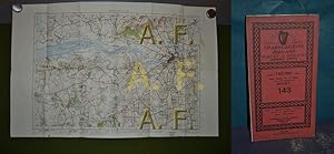
Survey of Ireland (Ordnance Survey), Sheet 143, 1 : 63.360 (ca. 58 x 37 cm)
Verlag: Dublin : Ordnance Survey Office Pheonix Park, 1947
Karte
Landkarte. 1 Bl. (gefaltene Karte) etw. bestaubt G1000c *.* Sprache: Englisch Gewicht in Gramm: 90.
-

Discovery Series. 88, Covering part of county : Cork = rcaigh
Verlag: Dublin: Ordnance Survey Office, 2015
Fifth Edition. Near fine pamphlet copy; edges slightly dulled. Particularly well-preserved overall; tight, bright and clean. Series: Discovery Series / Ordnance Survey of Ireland; 88. Physical description: 1 map: col.; 64 x 84 cm., on sheet 76 x 99 cm., originally folded to 20 x 12 cm. Subjects: Cork (Irlande ; comté). Celtic Sea (Irlande; mer). Irlande. Ireland; Maps. Scale 1:50,000. Genre: Maps. 1 Kg.
-

Fourth Edition. Near fine pamphlet copy; edges slightly dulled. Particularly well-preserved overall; tight, bright and clean. Series: Discovery Series / Ordnance Survey of Ireland; 81. Physical description: 1 map: col.; 64 x 84 cm., on sheet 76 x 99 cm., originally folded to 20 x 12 cm. Subjects: Irlande. Ireland; Maps. Scale 1:50,000. Ireland; Maps, Topographic. Genre: Maps. 1 Kg.
-

Kilkenny Tipperary Laois = Cill Channigh Tiobraid Árann Laois / compiled, printed and published by the Director at the Ordnance Survey Office
Verlag: Dublin: Ordnance Survey Office, 2011
Third Edition. Near fine pamphlet copy; edges slightly dulled. Particularly well-preserved overall; tight, bright and clean. Series: Discovery Series / Ordnance Survey of Ireland; 60. Physical description: 1 map: col.; 64 x 84 cm., on sheet 76 x 99 cm., originally folded to 20 x 12 cm. Subjects: Irlande. Ireland; Maps. Scale 1:50,000. Ireland; Maps, Topographic. Genre: Maps. 1 Kg.
-
Paper, railways revised 1944. Good, with a couple of faint marks to cover.
-
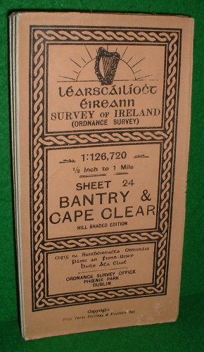
SURVEY OF IRELAND SHEET 24 ORDANCE SURVEY BANTRY & CAPE CLEAR MAP Hill Shaded Edition 1913
Verlag: Ordnance Survey Office / O/S, DUBLIN , Ireland / SOUTHAMPTON, 1913
Paper Back. Zustand: VG. Map Mounted on Linen.Sheet 24, Half inch to one mile. Salmon Covers with black lettering and decs. Map states" issued by OS Southampton 1913" Cover states" Ordnance Survey Office Phoenix Park Dublin". VG ( minor wear and light soiling to rear cover with 75mm approx diagonal crease) Please see our images of the actual map offered for sale. Size: 185x100mm Approx. Book.
-
![Bild des Verkäufers für Ireland [General Ordnance Survey Map of Ireland] zum Verkauf von Joseph Valles - Books](https://pictures.abebooks.com/inventory/md/md12092956057.jpg)
Ireland [General Ordnance Survey Map of Ireland]
Verlag: Dublin : Ordnance Survey Office, Learscailiocht Eireann, 1985, 1985
Soft cover. Zustand: Fine. No Jacket. 1 map ( : col. ; 65x80cm) ; Scale: 1: 575,000. ; LC: G5780 1985 ; OCLC: 264093557 ; fold-out map of Ireland ; FINE. Book.
-
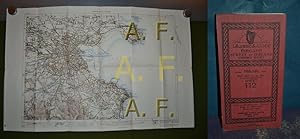
C° Dublin, Survey of Ireland (Ordnance Survey), Sheet 112, 1 : 63.360 (ca. 57 x 37 cm)
Verlag: Dublin : Ordnance Survey Office Pheonix Park, 1948
Karte
Landkarte. 1 Bl. (gefaltene Karte) bestaubt G1000c *.* Sprache: Englisch Gewicht in Gramm: 150.
-
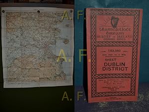
Dublin District, Survey of Ireland (Ordnance Survey), Sheet, 1 : 63.360 (ca. 68,5 x 76 cm)
Verlag: Dublin : Ordnance Survey Office Pheonix Park, 1944
Karte
Landkarte. 1 Bl. (gefaltene Karte) bestaubt u. eingerissen G1000c *.* Sprache: Englisch Gewicht in Gramm: 150.