
Gesamtpreis (1 Artikel Artikel):
Versandziel:

ocean explorer maps (91 Ergebnisse)
Direkt zu den wichtigsten Suchergebnissen
Suchfilter
Produktart
- Alle Product Types
- Bücher (76)
- Magazine & Zeitschriften (Keine weiteren Ergebnisse entsprechen dieser Verfeinerung)
- Comics (Keine weiteren Ergebnisse entsprechen dieser Verfeinerung)
- Noten (Keine weiteren Ergebnisse entsprechen dieser Verfeinerung)
- Kunst, Grafik & Poster (Keine weiteren Ergebnisse entsprechen dieser Verfeinerung)
- Fotografien (Keine weiteren Ergebnisse entsprechen dieser Verfeinerung)
- Karten (15)
- Manuskripte & Papierantiquitäten (Keine weiteren Ergebnisse entsprechen dieser Verfeinerung)
Zustand Mehr dazu
- Neu (81)
- Wie Neu, Sehr Gut oder Gut Bis Sehr Gut (5)
- Gut oder Befriedigend (4)
- Ausreichend oder Schlecht (1)
- Wie beschrieben (Keine weiteren Ergebnisse entsprechen dieser Verfeinerung)
Einband
- alle Einbände
- Hardcover (Keine weiteren Ergebnisse entsprechen dieser Verfeinerung)
- Softcover (5)
Weitere Eigenschaften
- Erstausgabe (Keine weiteren Ergebnisse entsprechen dieser Verfeinerung)
- Signiert (Keine weiteren Ergebnisse entsprechen dieser Verfeinerung)
- Schutzumschlag (Keine weiteren Ergebnisse entsprechen dieser Verfeinerung)
- Angebotsfoto (31)
- Keine Print-on-Demand Angebote (91)
Sprache (1)
Gratisversand
Land des Verkäufers
Verkäuferbewertung
-
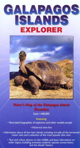
Galapagos Islands : Explorer (Ocean Explorer Maps)
Anbieter: WorldofBooks, Goring-By-Sea, WS, Vereinigtes Königreich
Verkäuferbewertung 5 von 5 Sternen

EUR 9,57
EUR 6,49 Versand
Versand von Vereinigtes Königreich nach USAAnzahl: 1 verfügbar
In den WarenkorbPaperback. Zustand: Very Good. The book has been read, but is in excellent condition. Pages are intact and not marred by notes or highlighting. The spine remains undamaged.
-
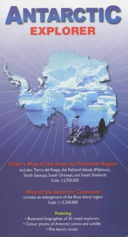
Antarctic Explorer: Visitor's Map of the Antarctic Peninsula Region and Map of the Antarctic Continent (Ocean Explorer Maps)
Anbieter: WorldofBooks, Goring-By-Sea, WS, Vereinigtes Königreich
Verkäuferbewertung 5 von 5 Sternen
EUR 10,39
EUR 6,49 Versand
Versand von Vereinigtes Königreich nach USAAnzahl: 2 verfügbar
In den WarenkorbPaperback. Zustand: Very Good. The book has been read, but is in excellent condition. Pages are intact and not marred by notes or highlighting. The spine remains undamaged.
-

Caribbean Islands Explorer: Visitor's Map of the Caribbean Islands and Map of the Leeward and Windward Islands (Ocean Explorer Maps)
Anbieter: WorldofBooks, Goring-By-Sea, WS, Vereinigtes Königreich
Verkäuferbewertung 5 von 5 Sternen
EUR 12,18
EUR 6,49 Versand
Versand von Vereinigtes Königreich nach USAAnzahl: 1 verfügbar
In den WarenkorbPaperback. Zustand: Good. The book has been read but remains in clean condition. All pages are intact and the cover is intact. Some minor wear to the spine.
-
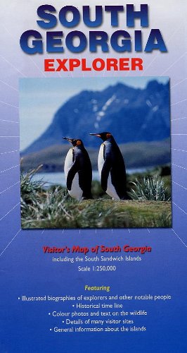
South Georgia Explorer (Folded)
Sprache: Englisch
Verlag: Ocean Explorer Maps, Chichester, 2011
ISBN 10: 0957002807 ISBN 13: 9780957002807
Anbieter: Grand Eagle Retail, Bensenville, IL, USA
Verkäuferbewertung 5 von 5 Sternen
Folded. Zustand: new. Folded. A fold-out visitor's map (scale 1: 250 000), that measures approximately 75 46 cm (W H) when unfolded. Colour photos and text highlight major visitor sites. There are several information boxes giving an overview of the island's history and wildlife, notable people in the island's history and a time line from 1675 to 2010. Shipping may be from multiple locations in the US or from the UK, depending on stock availability.
-
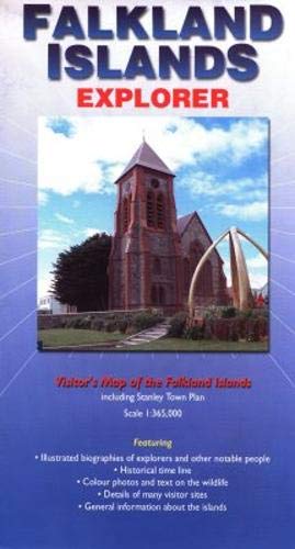
Falkland Islands Explorer (Folded)
Sprache: Englisch
Verlag: Ocean Explorer Maps, Chichester, 2007
ISBN 10: 0954371747 ISBN 13: 9780954371746
Anbieter: Grand Eagle Retail, Bensenville, IL, USA
Verkäuferbewertung 5 von 5 Sternen
Folded. Zustand: new. Folded. A fold-out visitor's map (scale 1 : 365 000), that measures approximately 75 46 cm (W H) when unfolded. Produced in the same format as the previous maps in the series, one side provides a detailed map of the islands with key areas identified, while the other side presents information of the areas wildlife, geography and history, along with providing a town plan to Stanley. Part of the "Ocean Explorer" series, this work covers the Falkland Islands region. It provides a detailed map of the islands with key areas identified. It presents information of the areas wildlife, geography and history, along with providing a town plan to Stanley. Shipping may be from multiple locations in the US or from the UK, depending on stock availability.
-
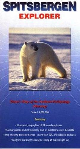
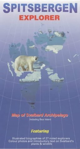
Spitsbergen Explorer (Folded)
Sprache: Englisch
Verlag: Ocean Explorer Maps, Chichester, 2001
ISBN 10: 0953861813 ISBN 13: 9780953861811
Anbieter: Grand Eagle Retail, Bensenville, IL, USA
Verkäuferbewertung 5 von 5 Sternen
Folded. Zustand: new. Folded. This map is designed to appeal to passengers on cruises that visit Svalbard, but it should also be of interest to those who explore the archipelago in other ways. It includes an explanation of why most of the world calls it Spitsbergen, but Norwegians use the name Svalbard. Special features include illustrated biographies of explorers and other historic figures; notes on the history and unique political status of this land far to the north of the Arctic Circle; locations of Svalbard's national parks and nature reserves (representing more than 50 per cent of the land area); and colour photographs and text on the plants and animal life. Though twice the size of Belgium, 60 per cent of Svalbard is covered by snow and glaciers. Because this map primarily addresses the needs of visitors who explore the area on ships, the emphasis is on popular landing places and geographical features that can be seen from the sea or which are near the shore. With this focus, land-based travellers will find little or no information here about shore-side restaurants, hotels and other lodging places, or highways, railroads and airports. Covers the Arctic archipelago (named Spitsbergen when discovered by the Dutch in 1596, but now commonly referred to as Svalbard). This title features a map of the archipelago, with annotations. It includes biographical summaries of 27 explorers as well as descriptions and colour photographs of the common plants, invertebrates, birds and mammals. Shipping may be from multiple locations in the US or from the UK, depending on stock availability.
-
South Georgia Explorer
Anbieter: PBShop.store UK, Fairford, GLOS, Vereinigtes Königreich
Verkäuferbewertung 5 von 5 Sternen
EUR 13,62
EUR 3,81 Versand
Versand von Vereinigtes Königreich nach USAAnzahl: 2 verfügbar
In den WarenkorbUNK. Zustand: New. New Book. Shipped from UK. Established seller since 2000.
-
Spitsbergen Explorer
Anbieter: PBShop.store UK, Fairford, GLOS, Vereinigtes Königreich
Verkäuferbewertung 5 von 5 Sternen
EUR 13,62
EUR 3,81 Versand
Versand von Vereinigtes Königreich nach USAAnzahl: 6 verfügbar
In den WarenkorbUNK. Zustand: New. New Book. Shipped from UK. Established seller since 2000.
-
Galapagos Islands Explorer
Anbieter: PBShop.store UK, Fairford, GLOS, Vereinigtes Königreich
Verkäuferbewertung 5 von 5 Sternen
EUR 15,73
EUR 3,81 Versand
Versand von Vereinigtes Königreich nach USAAnzahl: 14 verfügbar
In den WarenkorbUNK. Zustand: New. New Book. Shipped from UK. Established seller since 2000.
-
Antarctic Explorer
Anbieter: PBShop.store UK, Fairford, GLOS, Vereinigtes Königreich
Verkäuferbewertung 5 von 5 Sternen
EUR 15,73
EUR 3,81 Versand
Versand von Vereinigtes Königreich nach USAAnzahl: 15 verfügbar
In den WarenkorbUNK. Zustand: New. New Book. Shipped from UK. Established seller since 2000.
-
Antarctic Explorer (Folded)
Sprache: Englisch
Verlag: Ocean Explorer Maps, Chichester, 2009
ISBN 10: 0954371763 ISBN 13: 9780954371760
Anbieter: Grand Eagle Retail, Bensenville, IL, USA
Verkäuferbewertung 5 von 5 Sternen
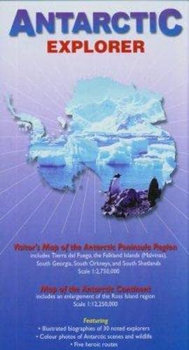
Folded. Zustand: new. Folded. A fold-out visitor's map (scale 1 : 2 750 000 for the Antarctic Peninsula Region and 1 : 12 250 000 for the Antarctic Continent), that measures approximately 100 69 cm (W H) when unfolded. On one side there is a map of the Antarctic continent, around which succinct biographies of Antarctic explorers from William Spiers Bruce to Edward Wilson are shown. On the other side there are many fine colour photographs of seals, penguins and other Antarctic wildlife, together with an inset box summarising the Antarctic Treaty and other information on Antarctic waters, Cape Horn, Tierra del Fuego, the Beagle Channel, the Falkland Islands and South Georgia. Aimed at visitors arriving by sea. A foldout map of Antarctica continent that shows succinct biographies of Antarctic explorers from William Spiers Bruce to Edward Wilson. It is suitable for visitors arriving by sea. Shipping may be from multiple locations in the US or from the UK, depending on stock availability.
-

Galapagos Islands Explorer (Folded)
Sprache: Englisch
Verlag: Ocean Explorer Maps, Chichester, 2009
ISBN 10: 0954371771 ISBN 13: 9780954371777
Anbieter: Grand Eagle Retail, Bensenville, IL, USA
Verkäuferbewertung 5 von 5 Sternen
Folded. Zustand: new. Folded. The young, volcanic, Galapagos Archipelago is made up of over 130 islands and islets, although only five are actually inhabited. A province of Ecuador, they are located on the Equator, about 1,000 km (about 600 miles) to the west of South American mainland. Aside from their natural beauty, and the opportunities for exploration by sea, the Galapagos Islands are intimately associated with scientific research. While this may have begun with Charles Darwin's brief visit in 1835, today the emphasis is on conservation research, and the islands and surrounding marine reserve form a UNESCO Natural World Heritage Site.The Galapagos Islands Explorer is a fold-out visitor's map (scale 1 : 400 000), that measures approximately 100 69 cm (W H) when unfolded. It also has sections on human history, conservation, National Park Rules, the various island names (Ecuadorian and English), a timeline, and biographies of the significant people in Galapagos history. It will complement a trip to the islands, and help you make the most of your time there.Mapping has come a long way since the islands first appeared on Gerardus Mercator's map in 1569, and the Galapagos Islands Explorer is the perfect companion for a visit to the archipelago. As well as the map itself, the Explorer gives a general introduction to the geology, climate, and geography of the islands, plus background background information on the flora and fauna you can expect to see - from Galapagos cotton to the famous iguanas and giant tortoises. There is concise and practical information on each of the main islands as well as the most popular dive sites. The volcanic Galapagos Archipelago is made up of over 130 islands and islets, although only five are actually inhabited. Aside from their natural beauty, and the opportunities for exploration by sea, the Galapagos Islands are intimately associated with scientific research. This title features biographies of explorers and other notable people. Shipping may be from multiple locations in the US or from the UK, depending on stock availability.
-

Galapagos Islands : Explorer (Ocean Explorer Maps)
Anbieter: Solr Books, Lincolnwood, IL, USA
Verkäuferbewertung 5 von 5 Sternen
Zustand: acceptable. This book is in Acceptable condition. All pages are intact, but may have lots of notes, water damage or other issues and be ex library.
-
Spitsbergen Explorer
Anbieter: Majestic Books, Hounslow, Vereinigtes Königreich
Verkäuferbewertung 4 von 5 Sternen

EUR 13,84
EUR 7,53 Versand
Versand von Vereinigtes Königreich nach USAAnzahl: 3 verfügbar
In den WarenkorbZustand: New.
-
Falkland Islands Explorer: Visitors Map of the Falklands.
Anbieter: Majestic Books, Hounslow, Vereinigtes Königreich
Verkäuferbewertung 4 von 5 Sternen
EUR 13,84
EUR 7,53 Versand
Versand von Vereinigtes Königreich nach USAAnzahl: 3 verfügbar
In den WarenkorbZustand: New.
-
Spitsbergen Explorer
Anbieter: Revaluation Books, Exeter, Vereinigtes Königreich
Verkäuferbewertung 5 von 5 Sternen
Karte
EUR 10,63
EUR 11,59 Versand
Versand von Vereinigtes Königreich nach USAAnzahl: 2 verfügbar
In den WarenkorbMap. Zustand: Brand New. 1 pages. 8.98x4.57x0.08 inches. In Stock.
-
South Georgia Explorer: Visitor's Map of South Georgia Including the South Sandwich Islands (Ocean Explorer Maps)
Anbieter: Revaluation Books, Exeter, Vereinigtes Königreich
Verkäuferbewertung 5 von 5 Sternen
Karte
EUR 10,63
EUR 11,59 Versand
Versand von Vereinigtes Königreich nach USAAnzahl: 2 verfügbar
In den WarenkorbMap. Zustand: Brand New. 2nd revised edition edition. 1 pages. 8.58x0.16x4.65 inches. In Stock.
-
Falkland Islands Explorer: Visitors Map of the Falklands Islands Including Stanley Town Plan (Ocean Explorer Maps)
Anbieter: Revaluation Books, Exeter, Vereinigtes Königreich
Verkäuferbewertung 5 von 5 Sternen
Karte
EUR 10,63
EUR 11,59 Versand
Versand von Vereinigtes Königreich nach USAAnzahl: 2 verfügbar
In den WarenkorbMap. Zustand: Brand New. 2 pages. 9.00x5.00x0.20 inches. In Stock.
-
Zustand: New.
-
-
Galapagos Islands Explorer
Anbieter: Majestic Books, Hounslow, Vereinigtes Königreich
Verkäuferbewertung 4 von 5 Sternen
EUR 16,44
EUR 7,53 Versand
Versand von Vereinigtes Königreich nach USAAnzahl: 3 verfügbar
In den WarenkorbZustand: New. Illus.
-
Antarctic Explorer
Anbieter: Majestic Books, Hounslow, Vereinigtes Königreich
Verkäuferbewertung 4 von 5 Sternen
EUR 16,44
EUR 7,53 Versand
Versand von Vereinigtes Königreich nach USAAnzahl: 3 verfügbar
In den WarenkorbZustand: New.
-
Galapagos Islands Explorer: Visitor's Map of the Galapagos Islands
Anbieter: Revaluation Books, Exeter, Vereinigtes Königreich
Verkäuferbewertung 5 von 5 Sternen
Karte
EUR 13,43
EUR 11,59 Versand
Versand von Vereinigtes Königreich nach USAAnzahl: 2 verfügbar
In den WarenkorbMap. Zustand: Brand New. 2nd revised edition edition. 1 pages. 8.90x4.90x0.50 inches. In Stock.
-
Falkland Islands Explorer
Anbieter: Kennys Bookshop and Art Galleries Ltd., Galway, GY, Irland
Verkäuferbewertung 5 von 5 Sternen
Zustand: New. 2007. Map. . . . . .
-
Spitzbergen Explorer
Anbieter: Kennys Bookshop and Art Galleries Ltd., Galway, GY, Irland
Verkäuferbewertung 5 von 5 Sternen
Zustand: New. 2010. Map. Covers the Arctic archipelago (named Spitsbergen when discovered by the Dutch in 1596, but now commonly referred to as Svalbard). This title features a map of the archipelago, with annotations. It includes biographical summaries of 27 explorers as well as descriptions and colour photographs of the common plants, invertebrates, birds and mammals. Editor(s): Sitwell, Nigel; Riffenburgh, Beau; Cruwys, Liz; Carlsson, Olle. Series: Ocean Explorer Maps. Num Pages: Col & B/w photos. BIC Classification: 1MTN; WTRM. Category: (G) General (US: Trade). Dimension: 222 x 102 x 2. Weight in Grams: 40. . . . . .
-
South Georgia Explorer: Visitor's Map of South Georgia Including the South Sandwich Islands (Ocean Explorer Maps)
Anbieter: Revaluation Books, Exeter, Vereinigtes Königreich
Verkäuferbewertung 5 von 5 Sternen
Karte
EUR 14,85
EUR 11,59 Versand
Versand von Vereinigtes Königreich nach USAAnzahl: 1 verfügbar
In den WarenkorbMap. Zustand: Brand New. 2nd revised edition edition. 1 pages. 8.58x0.16x4.65 inches. In Stock.
-
Zustand: New.
-
Zustand: New. 2nd Edition.
-
Spitsbergen Explorer
Anbieter: Biblios, Frankfurt am main, HESSE, Deutschland
Verkäuferbewertung 4 von 5 Sternen
Zustand: New.
-
South Georgia : Explorer (Ocean Explorer Maps)
Anbieter: Kennys Bookshop and Art Galleries Ltd., Galway, GY, Irland
Verkäuferbewertung 5 von 5 Sternen
Zustand: New. 2011. 2nd Revised edition. Map. . . . . .