Beschreibung
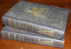
"2 volumes. 12mo., (7 ¾ x 4 7/8 inches). Fine folding engraved "Map of the Indian Territory Northern Texas and New Mexico showing the Great Western Prairies" (professionally repaired tear), full-page engraved "Map of the Interior of Northern Mexico," engraved frontispiece in each volume, 4 engraved plates (some spotting). Original publisher's brown cloth, decorated in gilt and in blind, the smooth spine lettered in gilt with the image of a Native American (rebacked, preserving much of the original spine, a bit rubbed). Provenance: Contemporary manuscript ownership inscription in each volume of Henry Washington Benham (1813-1884) dated June 11, 1848, Saltillo, Mexico. A HISTORICALLY SIGNIFICANT ASSOCIATION COPY First edition, first issue, with New York as the only place of publication. Wheat calls the folding map, which is one of the first to show the Staked Plains of Texas, "a cartographic landmark" (Wheat, Mapping the Transmississippi West II). Lauded as "one of the classics of bedrock Americana" (Dobie, p. 76), "Commerce of the Prairies" details Gregg's journey from Missouri across the prairies, carefully noting the geography and geology of the Southwest as well as important insights into the culture of the Native Americans living in Texas and New Mexico at the time. Henry Washington Benham fought in the Mexican-American War and served as a Union officer in the Civil War. Benham was an author and cartographer in his own right, using his knowledge of geography to help General Taylor win the Battle of Buena Vista. This is a VERY IMPORTANT ASSOCIATION COPY. At the beginning of the Mexican-American War, "the U.S. army did not have a reliable map of northern Mexico" (Saxon, p. 135). In fact, Gregg's map of Northern Texas and the Indian Territory was one of only three maps of the region available at the time. "Benham was placed in charge of the supply trains used to ferry men and supplies from Camargo to Monterrey and ultimately to Taylor's encampment. It took each train a week to make the trip, and the trains each included forty to sixty wagons. Benham brought the last train in before the Battle of Buena Vista. One of Benham's passengers on the final leg of the journey was Josiah Gregg, famous mountain man, author of the popular book 'Commerce of the Prairies,' and eyewitness to the battle that would later occur" (Saxon, pp. 133-134). Gregg greatly assisted Benham in the creation of his important map "Reconnaissance of the Route from Monterey to Saltillo and Mazapil." This copy of Gregg's book is inscribed with the location "Saltillo," dated 1848, only one year after Benham created his influential map. "The latitudes and elevations Benham used on the map were furnished by Josiah Gregg from his notes. Gregg accompanied Benham to the Saltillo area and was an eyewitness to the Battle of Buena Vista…[T]his map had little field application. Rather Benham produced the map to satisfy the chief engineer's and Washington's craving for detailed information on Mexico" (Saxon, p. 146). "A cornerstone of all studies on the Santa Fe Trail in the early period, describing the origin and development of the trade, Gregg's own experiences, and useful statistics for 1822-43" (Rittenhouse). J. Frank Dobie, "Guide to Life and Literature of the Southwest: With a Few Observations." Gerald D. Saxon, "Henry Washington Benham: A U.S. Army Engineer's View of the U.S.-Mexican War," in "Mapping and Empire: Soldier-Engineers on the Southwestern Frontier" (Dennis Reinhartz and Gerald D. Saxon, editors). Wagner- Camp 108:1; Graff 1659; Howes G-401; Rittenhouse 225; Streeter Sale I:378; Streeter, Texas 1502; Sabin 28712.". Bestandsnummer des Verkäufers 72MMS180
Verkäufer kontaktieren
Diesen Artikel melden
![]()

