Beschreibung
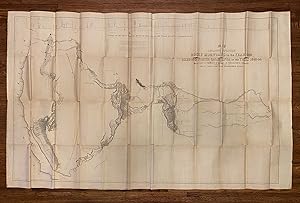
Thick 8vo (23.5 x 16 cm). 693 [1 blank] pp., 5 lithographic maps (list below), 22 lithographed plates (views, fossils, botany), 3 of the maps and 12 of the plates are attributed to Weber in image. Original blindstamped dark brown cloth, spine gilt-lettered (worn at extremities, particularly at head and tail of spine). Interior with moderate foxing and some browning, plates with moderate uniform foxing and browning, generally a good copy in original condition, unsophisticated. The large folding map is preserved in a separate mylar sleeve, good condition without any loss but with multiple characteristic splitting at folds as is always the case with this vastly oversized folding map (SEE IMAGES), original pocket at rear separating from lower board edge. With faults, and priced accordingly. FIRST EDITION OF ONE OF THE MONUMENTAL WORKS OF WESTERN EXPLORATION. This copy belongs to the PREFERRED SENATE ISSUE, containing the astronomical and meteorological observations that were omitted from the House issue and subsequent editions. Our copy is complete with all 22 plates and 5 maps, including the huge and justly famous 50" x 30" map (see below). "John C. Frémont s 'Report of the Exploring Expedition to the Rocky Mountains.and to Oregon and California' can only be described as one of the monumental works of Western exploration. Although preceded by mountain men and immigrants, Frémont opened the West to an entire nation. By accurately describing this vast territory from the Missouri River to the Pacific Ocean, his government report became the vade mecum of Manifest Destiny. Its words, maps, and pictures paved the way for future waves of overlanders culminating in the flood tide of the Gold Rush. Historians from Hubert Howe Bancroft to William H. Goetzmann bestowed upon the "Pathfinder" the highest praise for his accomplishments as a scientific explorer. The celebrated savant, Alexander von Humboldt, congratulated Frémont as a geographer and explorer and Brigham Young, the great Mormon prophet, read with keen interest his description of the Salt Lake Valley and its potential as a new Zion. Frémont, as he readily acknowledged, benefited from a superb supporting cast beginning with his wife and amanuensis, Jesse Benton Frémont; his powerful father-in-law, Senator Thomas Hart Benton; and his courageous and knowledgeable scouts and scientists including Kit Carson, Thomas Fitzpatrick, Alexis Godey, and Charles Preuss. His reports and those of his later expeditions made him a national hero and a charismatic symbol of American expansionism." (Gary Kurutz in Volkmann, Zamorano 80 catalogue). MAPS: 1. [Untitled emigrant route in Bear River Valley]. Sheet size: 49 x 22.5 cm. 2. Beer Springs [lower right] Lith by E Weber & Co. Sheet size: 22.5 x 14.5 cm. 3. The Great Salt-Lake. Sheet size 22.5 x 14.5 cm. 4. [Untitled map of the crossing of the Sierra Nevada by the South Fork of the American River] [lower center] Lith. by E. Weber & Co. Baltimore, Md. Sheet size: 22.5 x 64 cm. 5. Map of an Exploring Expedition to the Rocky Mountains in the Year 1842 and to Oregon & North California in the Years 1843-44 by Brevet Capt. J. C. Frémont of the Corps of Topographical Engineers under the Orders of Col. J. J. Abert, Chief of the Topographical Bureau. Lith. by E. Weber & Co., Baltimore, Md. [profile at top] Profile of the Route from the Mouth of the Kansas to Pacific by Capt. J. C. Fremont in 1843. Neat line to neat line: 78 x 129 cm (30" x 50"). Water courses and lakes highlighted in blue. Rumsey 1833 (House issue): "The large map of the west is one of the most interesting and beautiful government maps of the 1840s. It filled in many of the gaps in cartographic knowledge of the west. Charles Preuss was the cartographer." Wheat, Mapping the Transmississippi West, no. 497: "[Frémont s report and gigantic map] changed the entire picture of the West [and] represented as important a step forward from the earlier western maps of the period as did those of Pike, Bestandsnummer des Verkäufers 3952
Verkäufer kontaktieren
Diesen Artikel melden
![]()


