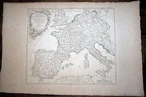
Imperium Caroli Magni. Occidentis Imperatoris / Map
VAUGONDY, D. Robert De
Verkäufer DR Fine Arts, New York, NY, USA
Verkäuferbewertung 5 von 5 Sternen
AbeBooks-Verkäufer seit 8. November 1997
Verkäufer DR Fine Arts, New York, NY, USA
Verkäuferbewertung 5 von 5 Sternen
AbeBooks-Verkäufer seit 8. November 1997
Beschreibung
Dated 1752; covers the Impire of Caroli Magni; some text: "usque Marc Balticum, protenditur"." cum privilegio"'; text in Latin: map show the England, Germany, France, Spain, top of Africa, some of Turkey and more, during Caroli Magni period; folded / attached in the middle and the back it has print the number 12, so apparently this was a print/map from a book; paper size: 33 x 23in, image size: 22 x 19 in; the paper has an invisible water mark in the hand made paper; there is green borders for the Impire, Spain would have been Moslum at the time; a little rubbing and just a little foxing and a tiny spot in margins; just a little normal browning to all the map; overall the map is in GOOD COND. Bestandsnummer des Verkäufers 4407
Bibliografische Details
Titel: Imperium Caroli Magni. Occidentis ...
Verlag: 1752
Erscheinungsdatum: 1752
Einband: No Binding
Zustand: Good
Auflage: 1st Edition
Anbieterinformationen
PAYMENTS: Within the US and for International orders we accept Credit Cards only thru ABEbooks Secure Credit Card System. DEALERS: Absolutely no "Drop/Ship" orders within the USA or Internationally (If this slips by us, the middle person is responsible for informing their client of our return policies and for all returned damaged items). POSTAGE & INSURANCE are not included: tracking & insurance at buyer's cost and on buyer's request. We encourage all International orders over $150 to use Priori...
Mehr InformationShipping costs are based on books weighing 2.2 LB, or 1 KG. If your book order is heavy or oversized, we may contact you to let you know extra shipping is required.
Zahlungsarten
akzeptiert von diesem Verkäufer