Beschreibung
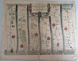
John Ogilby Plate 74: The Road from Ipswich com Suffolk to Norwich and thence to Cromer on the Sea Coast Engraved road map. Plate 74 from John Ogilby Britannia, Volume the First. Or, an Illustration of the Kingdom of England and Dominion of Wales: by a Geographical and Historical Description of the Principal Roads thereof. Probably the first edition of 1675, printed for the author. Copper engraving. Some hand colouring. Plate size: 33 x 44.5 cms, paper size 37.5x48 cms. Good condition, centre and later folds, no offsetting, light browning, reasonable margins, slight scuffing at the edges. This beautiful road map is from John Ogilvy's Britannia, which was the first account of the roads of England and Wales. It was also the first graphic delineation of roads which established the practice of representing the road as a straight line, divided here into vertical strips. This plate 74 shows the route from Ipswich to Norwich. The six strips show each, village, town, wood brook and other geographical features, as well as milestone. Each section has a compass rose showing North. At the top is a large decorated cartouche at the centre with the royal cypher. The engraving is partially coloured, that is the decorative swags round the cartouche, the compasses, roads, towns and sea have been painted in watercolour, probably quite early. Paper defect beyond the plate mark middle bottom, 5x10 mm. Bestandsnummer des Verkäufers soas.jk.03
Verkäufer kontaktieren
Diesen Artikel melden
![]()
