Beschreibung
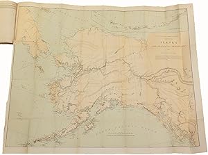
8vo., (9 ¼ x 6 1/8 inches). 4 fine folding lithographed maps (short tear near mount of Map 4). Modern quarter brown morocco, marbled boards. Provenance: From the distinguished library of Warren Heckrotte, his sale part III, PBA Galleries sale 581, March 10, 2016, Lot 7. First edition, Senate issue. Important report from President Cleveland on the continuing efforts to survey and delineate an accurate boundary between Alaska and British Columbia (Canada). After Alaska was ceded from Russia to the United States in 1867, there was great uncertainty as to the exact border between the Alaska territory and Canada. The report requests a preliminary survey of the boundary line in order to gather the necessary information to create a treaty between the U.S. and Great Britain, appropriating $100,000 for this purpose. The maps include: 1) U.S. Coast and Geodetic Survey…Alaska and Adjoining Territory 1884; 2) A Chart shewing part of the Coast of N.W. America; 3) Portland Canal and Observatory Inlet 1880; and 4) Revilla Gigedo Channel S. E. Alaska 1885. Falk, 1884-10 (Map 1). Falk, 1880-12 (Map 3). Falk, 1885-7 (Map 4). Bestandsnummer des Verkäufers 72MMS372
Verkäufer kontaktieren
Diesen Artikel melden
![]()


