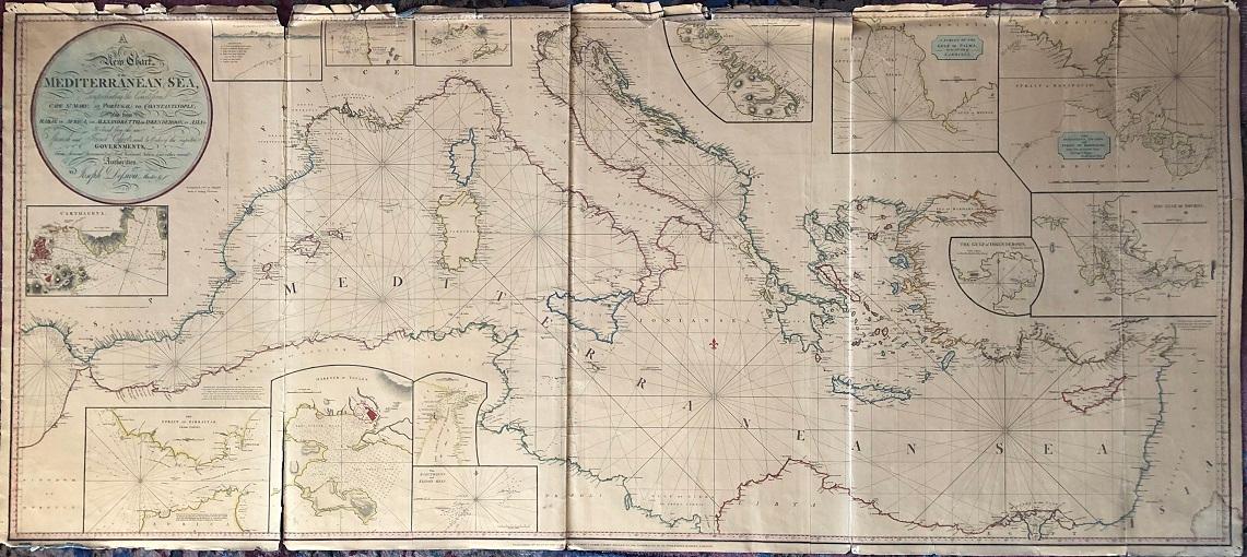
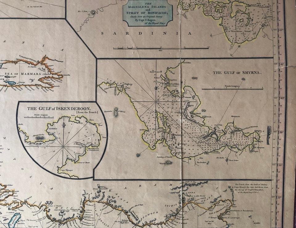
Beschreibung
A large copper engraved "blueback" map on paper, backed with the usual blue manila paper. Large coloured circular-bordered title in upper left, lettered in script. Entire map with contemporary colouring in outline. Thirteen small inset maps. Imprint at bottom: Published 2nd August, 1819, by Richard Holmes Laurie, Chart Seller to the Admiralty, &c.&c. No. 53, Fleet Street, London. Image size is 173cm x 76cm, on a sheet measuring 175cm x 78cm. The map is in five sections, four the same size and one smaller. Some splitting at folds, fraying to upper edge but very little loss, very good condition generally. Beneath the title is a note on the map: "Accompanied with an enlarged Book of Sailing Directions". WorldCat lists an edition of Laurie's book of directions [not present here]: "Laurie and Whittle's New Sailing Directions for the Mediterranean Sea . Written to accompany the New Chart of the Mediterranean Sea, and compiled from the best Authorities, aided by several original and valuable Manuscripts of the late Horatio, Lord Viscount Nelson . of Capt. G.F. Ryves, of the Royal Navy ; and of Joseph Dessiou, author of the Chart. The Second Edition, greatly enlarged and improved. [With a note on the pirated issue of the First Edition, published by Robert Blachford, of the Minories, London]. London : Robert Laurie and James Whittle, 1811. 112 pages. The only copy of this book cited is in the British Library, whose entry says: "Missing the chart". This 1819 edition of the chart is not cited by Hughes & Wall in their comprehensive work on Joseph Dessiou's publications, but they do cite an 1811 edition held by McMaster University, upon which it is based: [Dessioul4, McM: Laurie and Whittle's New Chart of the Mediterranean Sea Comprehending the Coast from Cape St. Mary, (in Portugal) to Constantinople, and from Rabat, in Africa, to Alexandretto, or Scanderoon in Asia. Joseph Dessiou, Master Mariner, Laurie and Whittle, 1811]. This 1811 edition has some variations from the 1819 edition in the title (Nelson is mentioned in both, but named differently), only ten inset maps (this 1819 edition has 13 insets), some different names (Skanderoon; this 1819 edition says Iskenderoon), and refers to itself beneath the title as "An Improved Edition, With Additions, 1811". This same chart is the basis of the [c.1826] edition which added information from the surveys of William Henry Smyth. The 1826 edition is the same size, contains more details and inset maps (19 insets), and some corrections ('Maddalena Islands' instead of 'Magdalena Islands'). All editions are very rare; the 1811 edition is known to us in two copies (McMaster University and University of Amsterdam); this copy of the 1819 edition is the only one we are able to locate; the 1826 edition is known in only one copy (Ruderman/Boston Rare Maps). Bestandsnummer des Verkäufers 55999
Verkäufer kontaktieren
Diesen Artikel melden