Beschreibung
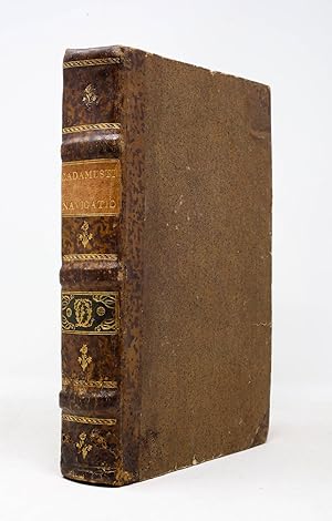
THE FIRST MAP TO SHOW THE EARTH REVOLVING ON ITS AXIS. First edition, map state A (Harrisse). Basel: Io[hannes] Hervagius, 1532. Pot folio in 6s (11 1/16" x 7 7/16", 231mm x 189mm). [Full collation available.] With a folding woodcut map (Harrisse A) of the world (inserted before p. 1). Bound in somewhat later half speckled calf over sprinkled boards. On the spine, three raised bands. In the panels, gilt floral central ornaments. Title (CADAMUSTI NAVIGATIO) gilt to a beige morocco label in the upper portion of the second panel. In the second panel, a gilt cipher (L O) in acanthus scrolls to a green morocco label. Marbled end-papers. All edges of the text-block stained red. Worming to the lower quarter of the spine, wrapping around to the front board. Some wear to the boards overall. Map with a repaired closed tear and with some small tears at the folds and margins. Internally, as so often, certain quires have tanned, but most are lovely and bright; generally quite good, with occasional foxing. Small round ex-libris label of "a.r.s." on the front paste-down. Violet inkstamps of the Collegio S. Carlo library and of "M.D" on the title-page. Although the map (rightly) has a nearly electromagnetic pull, being the first to indicate Copernicus' model of the revolving world (predating his 1543 De revolutionibus by 11 years), the book in which it was published is monumental in its own right: the first collection of voyages. The work -- indeed, both works contained in the present volume -- emerges from the humanistic forge of the German-speaking Protestant world. Johann Huttich (Huttichius, 1490-1544) was part of the embassy that led Charles V to Madrid to announce his election as Holy Roman Emperor. While there he gained access to the accounts of Spanish and Portuguese (or Iberian-funded) explorers of the Americas (Cadamosto (whence the title-label), Columbus, Niño, Pinzón, Vespucci, Peter Martyr d'Anghiera) in addition to a great many voyages elsewhere (including Marco Polo) in Eurasia. While most of these had been printed elsewhere, their union in a single edited work is the first time we can discern the genre of voyages. Simon Grynaeus (Griner, 1493-1541) was a student of Melanchthon's at Pforzheim, and is perhaps best known for finding and editing the first five books of Livy's history of Rome (1531) that would be published by Erasmus. His role, Harrisse and others argue, was principally as prefator. Sebastian Münster (1488-1552), whose principal job was professor of Hebrew, would nevertheless go on in 1544 to publish the Cosmographia, the first description of the world in German. Shirley attributes the map to him, and indeed his twelve-page description of the map and its use suggests at the very least a deep involvement in its production. The final name attached to the work is that of Hans Holbein (The Younger, 1497-1543), who cut the fanciful border of the map with its cannibals and elephant hunt. In short, the Novus Orbus is the collective effort of some of the great humane minds of the Protestant Reformation. The map is Harrisse A ("we are inclined to consider as the genuine map;" Shirley is agnostic about precedence), distinguished by the large "ASIA". As such it is the first visual representation of the revolutionary model of the world: it revolves around a notional axis, and it is that action that accounts for daily and seasonal change. Münster (or Holbein) depicts this with angels at the North and South Poles powering the revolution via crank. The Collegio S. Carlo (Milan? Modena) library stamp and the mysterious M.D within a beveled rectangle (as well as the "ex libris a.r.s.") do not yield much by way of ownership; they must nevertheless have taken rather good care of it for it to have survived so well to the present. Adams G-1334, Alden & Landis 532/17, Harrisse 171, John Carter Brown Library I, p. 104 (JCB I:101), Sabin 34100, Shirley 67. Bestandsnummer des Verkäufers 6JLR0080
Verkäufer kontaktieren
Diesen Artikel melden
![]()


