Beschreibung
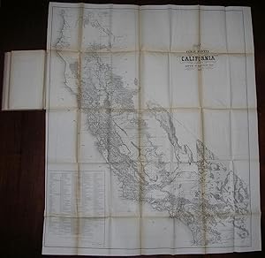
8vo., (9 x 6 inches). 10 fine folding lithographed maps (one or two short tears, uneven browning). Original purple publisher's cloth decorated in blind (spine faded to tan). Provenance: Manuscript ownership inscription to title page: "Wm P. Vails Feb. 4, 1864," and annotations to the versos of some maps. First edition. Includes ten large folding maps of new American territories: Washington, New Mexico, Dakota, Wisconsin and Minnesota, Colorado, Iowa and Dacota, Oregon, Kansas and Nebraska, California, and Minnesota, with some of the titles in a contemporary hand to verso. With regard to California, the "surveyor general recommends the subdivision of certain townships situated east and west of the bay of San Francisco, the valley of Sacramento river, in Big valley, west of Clear lake, in Anderson's valley, and along the rivers Noya, Big Albion, Navarro, and Garcia, in Mendocino county, and also a number of townships in the northeastern portion of the State; in the Pitt river valley, heretofore occupied, by roving, warlike Indians, who have been removed. That region is represented as being rapidly filled up with settlers, the lands as devoid of minerals, and well adapted for agricultural and grazing purposes." In Kansas and Nebraska, "one settlement ("Drywood") alone is represented as containing three or four hundred settlers, who have made valuable improvements. As it is understood that the Cherokee Indians are inclined to dispose of these neutral lands, the surveyor general recommends that the Indian title be extinguished as early as compatible with the public interest. Settlements also are reported on the Osage Indian lands embraced within a strip along the northern boundary eight miles wide. This tribe also, it is understood, are willing to dispose of the eastern portion of their lands." A fascinating look at Manifest Destiny in action. Bestandsnummer des Verk�ufers 72MMS33
Verk�ufer kontaktieren
Diesen Artikel melden

