Beschreibung
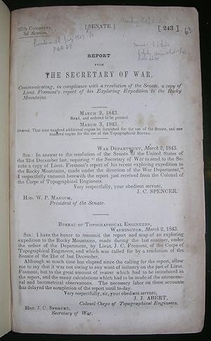
8vo., (8 7/8 x 5 4/8 inches). Single leaf: "Report from the Secretary of War." Tinted lithographic frontispiece and five plates, some tinted (some heavy spotting). Fine large folding map ".to illustrate an exploration of the Country, lying between the Missouri River and the Rocky Mountains, on the line of the Nebraska or Platte River" waterways hand-colored in blue (closed tear near mount). Modern green cloth; blue cloth slipcase and chemise. Provenance: Penciled note on the verso of the first blank stating that this is "Streeter's Copy"; bookplate of Josiah Kirby Lilly (1893-1966), bibliophile and member of the Lilly pharmaceutical dynasty on front paste-down. First edition, issue from the compilation of the Senate documents for the 27th Congress, 3rd Session, with a single leaf (page 243) "Report from the Secretary of War, communicating, in compliance with a resolution of the Senate, a copy of Lieut. Fremont's report of his Exploring Expedition to the Rocky Mountains" outlining the history of the report's reading to the Senate on March 2nd, 1843 and ordering the number of copies to be printed: ". that nine hundred additional copies be furnished for the use of the Senate, and one hundred copies for the use of the Topographical Bureau". "When emigration to the Oregon County became important in 1842, Fremont was sent to survey the route beyond the Mississippi as far as South Pass Wyoming. This route became famous as the "Oregon Trail". Fremont later led two expeditions into Alta California, and he played a major role in the American annexation of California in 1847 and was named governor there. He also led two later overland railroad surveys. In 1850, he became senator from California, and he ran for President as a Republican in 1856. After having served the Union in the Civil War, he was involved in the Southern Pacific Railway scandal, but later served as governor of the Arizona Territory. The text of this report appears in some edition of Fremont's "Report of the exploring expedition to the Rocky Mountains in the year 1842." (Hill). "The expedition was designed by Senator Benton and the expansionist group in Congress to publicize the first main division of the route to Oregon, for though this was well known to the fur traders, the region west of the Missouri was still terra incognita to the general public" (Streeter Sale 3130, describing his copy in original printed wrappers); Graff 1437 (printed wrappers, lacking first leaf); Grolier American Hundred #49: "Made clear the first half of the route to Oregon through the South Pass and cast doubts on the prevailing myth of a great American desert between the Missouri and the Rockies;" Hill 639; Howes F371; Sabin 25843; Wagner-Camp 95. Bestandsnummer des Verkäufers 001429
Verkäufer kontaktieren
Diesen Artikel melden
![]()


