Beschreibung
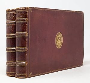
EUROPEAN DIPLOMATIC NETWORKS and CARTOGRAPHIC ESPIONAGE. Two volumes. Paris: Chez Sebastien Cramoisy, 1634. First edition. Oblong quarto (6 3/16" x 9 3/8", 157mm x 239mm). [Full collation available.] With 18 engraved part-titles, 18 engraved tables of contents, 409 engraved plates and 3 folding engraved plates (448 in total). Bound in contemporary chestnut morocco. On the boards, a double gilt fillet border with gilt corner rosettes and corner gilt fleurons. At the center of each board, the oval supralibros of van Wicquefort gilt. On the spine, six raised bands with a gilt fillet, flanked by double gilt fillets. Title gilt to the first panel. Number gilt to the second panel. Some scuffs and superficial cracking. A little loss to the head and tail of each volume. Generally a little tanned and a few passages of mild foxing. Shelfmarking (?) in ink manuscript to the top of the text-block and to the front paste-down of each volume. Vol. I: pen-trials to the front paste down. Purchase note ("Theophile Belin â ¤160 francs â ¤5.8.0/ April 8 1886") ink manuscript to the upper edge of the recto of the first free end-paper. Armorial bookplate of Mr. G. Chartener on the verso of the second free end-paper. Presentation inscription in ink manuscript: "Amico dignissimo dono misi/ Constantinus Hugerius./ 1635" on the title-page. Cancelled shelfmarking to the lower edge of the title-page. Vol. II: Cancelled shelfmarking to the lower edge of the title-page. Christophe (sometimes known as Nicolas) Tassin (d. 1660) became geographer and engineer to the king (Louis XIII) around 1630. The post came with publication privileges for a decade, during which he published atlases in this oblong quarto format with which he is closely associated. Tassin's Plans et Profils allowed the grandeur of France's cities in particular (in distinction to Braun & Hogenberg's catholic approach) to be shown to the world. Maps, plans and views work together to form the very best record of France flourishing under the ministry of Cardinal Richelieu. As early as 1628 Tassin acted as an architectural consultant to Frederik Hendrik, Prince of Orange. It was in this capacity that Tassin came to correspond with Constantijn Huygens, diplomat, composer, poet and secretary to the Prince of Orange. Their correspondence continued into the 1640's, and so it is likely that this was an author's presentation copy. Huygens did not, however, keep the volume. The dedication notes that he sent it to his "amico dignissimo" (worthiest friend), but does not name the friend. A letter (no. 1070), surviving only in a copy, clarifies: "Ook zend ik u de nieuwe werken van Tassin, waarin de plans van al de belangrijkste Fransche vestingen. Ultimo (31) Jan. 1635." (I am also sending to you the new works of Tassin, in which are the plans of all the most important French fortresses. On the last day of January 1635.). The supralibros matches those of the recipient of the letter: Joachim van Wicquefort (1600-1670). Wicquefort was also a Dutch diplomat, the agent of the Duke of Weimar. Huygens's letter makes clear that the volumes were more than aesthetic; they were tactical. Indeed, Peter Barber, former head of maps for the British Library, has described the place that gifts such as the present item had in early modern espionage. We can carry the route of this set further. After some time in the possession of the Wicquefort family, the volumes returned to France; the bookplate places them in the collection of the bibliophile Gustave Chartener of Metz (1813-1884), whose collection was sold by Hôtel Drouot 4-9 May 1885 and by Labitte 9-27 May 1885. It was probably acquired by Théophile Belin, the Paris bookseller, at that sale. Belin sold the books to an English client in 1886. They returned once again to France, entering the collection of the Musée de la Citadelle Vauban on Belle Île, off the south coast of Brittany. The set was purchased from their sale (Piasa, 16 July 2010). Bestandsnummer des Verkäufers JLR0200
Verkäufer kontaktieren
Diesen Artikel melden
![]()


